Planning a ghost town road trip to Lenado starts with driving roughly 16 miles from Aspen via Highway 82 and Woody Creek Road to reach this abandoned mining settlement at 8,540 feet. You’ll find remnants of a lead and zinc mining era that once supported nearly 300 residents, plus traces of a 1960s logging revival. Visit in summer or early fall for the best road conditions. There’s far more to uncover before you go.
Key Takeaways
- Lenado sits 16 miles from Aspen at 8,540 feet, accessible via Woody Creek Road and Highway 82 through rugged mountain terrain.
- Visit during July–August for the most accessible roads, peak wildflowers, and maximum daylight to explore the ghost town.
- Pack water, sun protection, layered clothing, a first aid kit, and vehicle emergency supplies for remote high-elevation travel.
- Lenado’s history spans late 19th-century lead and zinc mining, a wartime zinc revival in 1917, and a 1960s logging era.
- Nearby Ashcroft and Independence ghost towns, plus trails like Hunter Creek Trail, offer additional exploration opportunities during your visit.
The Mining Ruins and Isolation That Make Lenado Worth the Drive
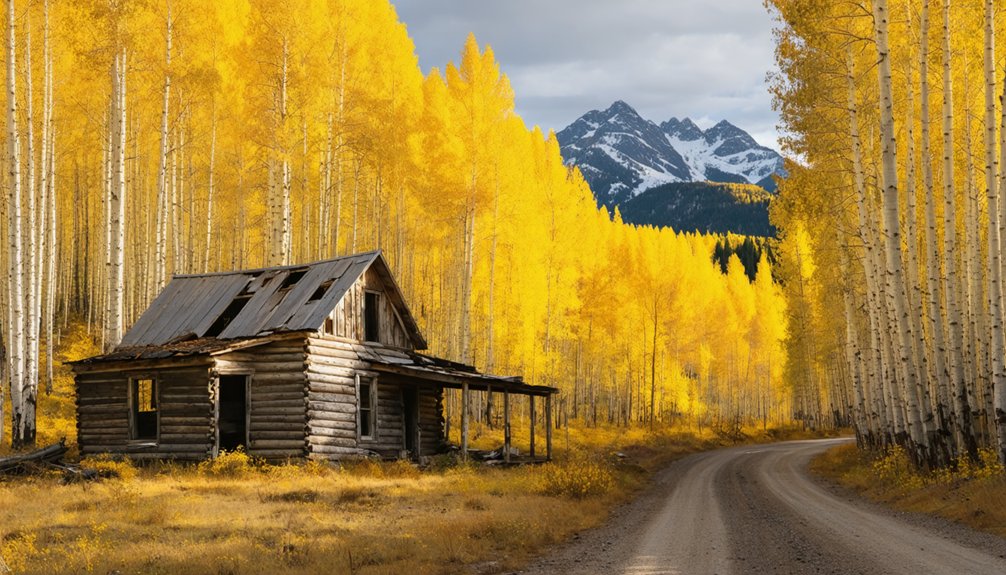
Perched at 8,540 feet in Pitkin County’s remote mountain terrain, Lenado isn’t your typical roadside ghost town — it earned its abandonment the hard way. Its mining history runs deep, built on lead and zinc deposits that once supported nearly 300 residents during peak years.
At 8,540 feet, Lenado earned its abandonment the hard way — built on lead, zinc, and hard luck.
When lead prices collapsed, so did the town.
What you’ll find today rewards the effort of getting here. The scenic isolation feels intentional — no crowds, no gift shops, just mountain silence and remnants of lives built around hard rock and harder luck.
A brief revival came after 1917 when wartime zinc demand spiked, but it didn’t last. Later, loggers returned in the 1960s, running a mill for 15 years before the land reclaimed its quiet again.
That layered past is exactly what makes Lenado compelling.
Where Is Lenado, Colorado? Elevation, Location, and Getting Your Bearings
Lenado sits at 8,540 feet in Pitkin County, tucked near Woody Creek along Woody Creek Road — roughly 16 miles from Aspen. That elevation isn’t just a number; it shapes everything about this place, from the thin air you’ll breathe to the rugged terrain you’ll navigate getting there.
Understanding Lenado geography helps you appreciate why this settlement thrived and ultimately faded. Remote mountain terrain meant isolation, and isolation meant vulnerability to economic shifts. When lead prices collapsed after peak mining years, residents simply left.
You’ll find the site by heading east out of Aspen, then following Woody Creek Road into the hills.
Ghost town history runs deep here, layered beneath decades of silence. Knowing where you’re headed makes the drive feel intentional — not just adventurous, but meaningful.
Lenado’s Mining Past: Lead, Zinc, and Why the Town Was Abandoned
Once you understand where Lenado sits, its mining history starts to make sense. The remote mountain terrain that makes the area feel so isolated today is exactly what drew miners here during the late 19th century. They came for lead and zinc deposits, working the surrounding hills with mining techniques suited to high-altitude extraction.
At its peak, roughly 300 people called Lenado home. But economic fluctuations hit hard when lead market prices collapsed, forcing residents to abandon the town entirely.
The place got a brief second wind after 1917, when World War I created urgent demand for zinc, temporarily reviving operations.
That surge didn’t last. When the wartime need disappeared, so did the town’s purpose, leaving Lenado quiet again among the pines.
How the Logging Era Gave Lenado a Second Life in the 1960s
When you think Lenado’s story ended with the mining bust, you’d be wrong—the mid-1960s brought the town roaring back to life as a logging site and lumber mill operation.
You can picture roughly 100 workers and their families settling in, transforming the abandoned landscape into a buzzing forest industry hub.
That second chapter lasted about 15 years before the community once again went quiet, leaving behind the layered history you’ll find when you visit today.
Lumber Mill Operations Begin
Decades after the mines fell silent, Lenado got a second wind in the mid-1960s when a lumber mill operation breathed new life into the abandoned settlement.
Workers arrived, tools rang out across the valley, and the forest industry transformed this quiet ghost town into a functioning community once again.
At its peak, around 100 people lived and worked onsite, writing a fresh chapter into Lenado’s logging history.
The lumber mill hummed for roughly 15 years before eventually closing, leaving behind another layer of historical significance for curious visitors like you to explore.
When you walk through the site today, you’re standing in a place that reinvented itself twice — first through mining, then through timber — making it a genuinely compelling stop on any Colorado ghost town road trip.
A 15-Year Logging Community
By the mid-1960s, Lenado had reinvented itself as a living, breathing logging community, drawing roughly 100 workers and their families back into this once-silent valley.
This economic revival lasted 15 years, proving that Lenado’s story wasn’t finished after the mines went quiet.
Here’s what defined this remarkable second chapter:
- Workforce: Approximately 100 people lived and worked onsite, creating a tight-knit mountain community.
- Purpose: A functioning lumber mill drove daily operations, replacing silver and zinc as the economic engine.
- Duration: The logging community sustained itself from the mid-1960s through the early 1970s before eventually closing.
- Legacy: This era bridged Lenado’s mining past with its current ghost town status.
You’re fundamentally visiting a place that reinvented itself twice.
Driving to Lenado From Aspen via Highway 82

Heading east out of Aspen on Highway 82 toward Independence Pass, you’ll wind through some of Colorado’s most dramatic mountain scenery before reaching the turnoff that sets you on course for Lenado.
The scenic views along these mountain roads rival anything you’ll find in the Rockies, so don’t rush the drive.
Once past Independence Pass, turn north on Highway 24 toward Leadville. From there, take the Turquoise Lake turnoff, passing the lake on its west side before continuing over Hagerman Pass.
This route covers roughly 16 miles from Aspen but demands your full attention — the terrain is rugged, and the roads aren’t forgiving. A capable vehicle isn’t optional here; it’s essential.
Stay sharp, follow your map closely, and you’ll reach Lenado’s historic site without trouble.
The Woody Creek Tavern Approach and the Turn Most Visitors Miss
If you’re approaching Lenado from the Woody Creek side, the Woody Creek Tavern serves as your key landmark before the road gets serious.
From there, you’ll drive roughly 10 miles before hitting the turn most visitors blow past entirely.
Don’t miss these four critical checkpoints:
- Note your mileage the moment you pass the Woody Creek Tavern
- Watch for the sharp right turn approximately 10 miles ahead — it sneaks up fast
- Slow your speed considerably as the terrain tightens and the road roughens
- Confirm your vehicle handles rugged mountain conditions before committing to the final approach
That sharp right turn separates casual drivers from those who actually reach Lenado.
Miss it, and you’ll find yourself backtracking through unfamiliar mountain terrain.
What Survives at the Lenado Ghost Town Site Today
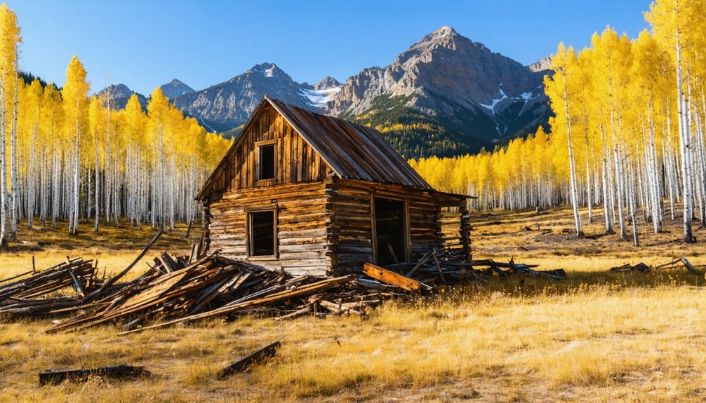
Once you’ve navigated that sharp right turn and pushed through the final stretch of rough mountain road, Lenado rewards you with something more tangible than most ghost towns offer.
Scattered remnants from both the mining and logging eras give the site genuine historical significance you can actually see and feel.
Lenado doesn’t just hint at its past — it lets you touch it, walk through it, and read it with your own hands.
You’ll find structural remains from the mid-1960s lumber mill operation alongside older evidence of the original lead and zinc mining community.
Unlike ghost towns stripped bare by souvenir hunters, Lenado retains enough physical character to spark real curiosity.
The surrounding mountain terrain and Turkey Creek trails add natural ghost town attractions beyond the ruins themselves.
You’re standing at 8,540 feet, reading a landscape that once supported 300 residents and then quietly emptied.
That silence tells its own story.
The Best Season to Visit Lenado Without Getting Stranded
Timing your visit to Lenado matters more than most ghost town trips because that rough mountain road doesn’t forgive poor planning.
Seasonal considerations directly affect your safety and access at 8,540 feet. The best time to explore sits within a narrow window.
- Summer (July–August): Roads are most accessible, wildflowers peak, and daylight gives you maximum exploration time.
- Early Fall (September): Crowds thin, aspen trees turn golden, and conditions remain manageable before early snowfall arrives.
- Late Spring (May–June): Snowmelt creates muddy, unstable roads — proceed only with four-wheel drive and local knowledge.
- Winter (November–April): Snow closes access entirely; attempting this route risks getting stranded miles from help.
Choose your window wisely, pack emergency supplies, and respect the mountain’s terms.
What to Pack for a High-Elevation Ghost Town Road Trip

Packing for Lenado isn’t like tossing gear into a bag for a casual day hike — you’re heading to 8,540 feet on rough mountain roads, miles from reliable help.
These high altitude essentials keep your trip moving forward: extra water, sun protection, layers for fast-changing mountain weather, and a basic first aid kit. Don’t underestimate how quickly altitude drains your energy.
Your packing tips should also cover the practical side of remote road travel. Bring a spare tire, tow strap, and jumper cables — nobody’s coming quickly if your vehicle quits.
Pack enough food for an extra day in case conditions shift unexpectedly. A paper map helps when your phone signal disappears, which it will.
Prepare smart, and Lenado rewards you with raw, unfiltered mountain history.
Nearby Ghost Towns and Trails Worth Pairing With Lenado
Lenado is worth the drive on its own, but the surrounding Pitkin County backcountry rewards explorers who push a little further.
Pair your visit with these standout destinations:
- Ashcroft Ghost Town – Just south of Aspen, this well-preserved site features abandoned structures from the 1880s silver boom, offering some of the region’s most photogenic ruins.
- Independence Ghost Town – Perched near Independence Pass, it delivers dramatic scenic viewpoints alongside crumbling cabins frozen in time.
- Hunter Creek Trail – A rugged path connecting mountain terrain with solitude and sweeping valley views.
- Hagerman Pass Road – This historic route traces old railroad grades through alpine landscape, linking Lenado’s era to Leadville’s mining legacy.
Each stop deepens the story you started at Lenado.
Frequently Asked Questions
Are There Any Entrance Fees to Visit the Lenado Ghost Town Site?
You won’t pay any entrance fees to explore Lenado’s historical significance! Just take your safety precautions seriously, respect the remote terrain, and you’re free to discover this enchanting Colorado ghost town on your own terms.
Is Camping Permitted Overnight Near the Lenado Ghost Town Area?
Don’t put the cart before the horse — check camping regulations before you pitch a tent! The knowledge base doesn’t confirm overnight permissions, so you’ll want to research nearby campsites independently for your Lenado adventure.
Can Visitors Legally Collect Artifacts or Souvenirs From the Lenado Site?
You shouldn’t collect artifacts from Lenado, as artifact preservation laws protect the site’s historical significance. Leave everything you find so future explorers can experience the same authentic connection to this fascinating ghost town’s rich past.
Are Pets Allowed on Trails Surrounding the Lenado Ghost Town?
The knowledge base doesn’t specify pet policies, but you’ll want to prioritize pet safety and trail etiquette by keeping your furry companion leashed on Lenado’s rugged mountain trails, respecting wildlife, and packing out all waste.
Does Cell Phone Service Exist Along the Road Leading to Lenado?
At 8,540 feet, cell service reliability drops dramatically. You’ll experience significant signal strength variations along Woody Creek Road’s remote terrain. Don’t count on consistent coverage—embrace the disconnected freedom this rugged mountain adventure naturally offers you.
References
- https://www.fs.usda.gov/Internet/FSE_DOCUMENTS/stelprdb5187032.pdf
- https://tranquiltrekker.com/central-colorado-ghost-towns-independence-pass/
- https://www.4x4explore.com/dest/dest_ghst.htm
- https://www.nationalgeographic.com/travel/article/ghost-towns-colorado-road-trip
- https://www.onlyinyourstate.com/trip-ideas/colorado/co-ghost-town-road-trip
- https://www.mirrorservice.org/sites/ftp.ibiblio.org/pub/docs/books/gutenberg/5/1/6/7/51678/51678-h/51678-h.htm
- https://www.facebook.com/groups/CoMinesHistory/posts/1139956723350416/
- https://en.wikipedia.org/wiki/List_of_ghost_towns_in_Colorado
- https://www.youtube.com/watch?v=PEZASHxQoTg
- https://999thepoint.com/the-ultimate-ghost-town-road-trip-through-colorado/


