
You’ll find Adamson’s haunting remnants along Hartshorne-Adamson Road in Pittsburg County, where about ten weathered homes still stand north of the old main street. Look for sunken ground and elongated ponds marking where Mine No. 1 collapsed in 1914, entombing fourteen miners forever. Anthony Benedict’s memorial monument honors his lost brothers on nearby farmland. Bring a camera and GPS device, as commercial businesses have vanished and only rusted warning signs guide your way. The full story of this coal boomtown’s tragic descent reveals even more forgotten landmarks worth discovering.
Key Takeaways
- Adamson is located in Pittsburg County, Oklahoma, with about 10 small homes remaining north of the old main street.
- Visit the 1914 mine disaster monument built by Anthony Benedict to honor fourteen miners entombed when Mine No. 1 collapsed.
- Observe ground subsidence of 8-10 feet that created elongated ponds and permanently altered the landscape after the mining collapse.
- Combine your trip with visits to nearby McAlester mining memorials, including Chadick Park’s mass grave for 59 miners.
- Explore Eufaula Lake’s submerged Creek Indian historical sites by boat, including North Fork Town and Standing Rock underwater.
The Rise and Fall of a Coal Mining Boomtown
When Peter Adamson sank his first mine shaft into the rich Choctaw Nation coalfields at the turn of the 20th century, he couldn’t have imagined the boomtown that would bear his name. By 1913, you’d find 3,500 souls packed into this thriving camp, where fifteen underground mines carved wealth from beneath Oklahoma’s red earth.
Rock Island and Katy railroad spurs snaked through town, hauling black gold to fuel locomotives across the frontier. Foreign miners—British, European, Mexican, and African American—built a diverse community around the shafts.
Then everything changed. Coal production declines gutted Adamson after 1920. By 1964, the shift to strip mining yielded a pathetic 448 tons countywide. Two years later, Pittsburg County disappeared from production reports entirely. The boomtown died.
The Tragic 1914 Mine Disaster That Changed Everything
At 3:30 p.m. on September 4, 1914, a cracking sound echoed through Mine No. 1—the kind of groan that makes every man underground freeze mid-swing. Foremen screamed evacuation orders, but fourteen miners working the bottom level never made it out. The ground swallowed them whole, sinking eight to ten feet and permanently entombing bodies that remain there still.
Anthony Benedict escaped as the last man, later building a monument on his farm to honor those lost brothers. The long term regional impact devastated Adamson—the town withered, production collapsed, and eventually the lake swallowed what remained. This disaster exposed the failures in the role of mine safety regulations, proving inspections alone couldn’t protect men choosing dangerous freedom over poverty’s chains.
What Remains of Adamson Today
A century after the disaster, Adamson barely clings to existence as a whisper of its former self. You’ll find about ten small homes still standing north of old main street, where remaining residents—mostly retirees and descendants of original mining families—quietly persist. The 2014 reports showed an active church flourishing among these survivors, though the post office and both grocery stores had already shuttered.
South of the main corridor, you’ll witness nature’s eerie reclamation: the ground has settled 8-10 feet between mine pillars, creating elongated ponds that scar the landscape. All fifteen flooded mines now leach highly mineralized water into nearby streams, creating severe water contamination issues that kill fish by the thousands. No commercial businesses survive here—just memories and warning signs of what unchecked industry leaves behind.
How to Find the Submerged Town Site at Eufaula Lake
Unlike Adamson’s visible decay above ground, North Fork Town requires you to look beneath the shimmering surface of Lake Eufaula—Oklahoma’s largest lake—where Creek Indian history dissolved into 102,200 acres of water.
Head east of the lake’s southernmost arm, where the Canadian and North Canadian Rivers once converged. During drought years, submerged town visibility improves dramatically as water levels drop, exposing foundations and forgotten roadways.
Contact the lake operations manager before your visit—they’ll pinpoint historical sites using old survey maps and historical investigation techniques passed down from pre-1964 flooding records. You’ll need a boat to explore properly, since North Fork Town rests underwater near where Belle Starr once rode.
Even Standing Rock, that 63-foot landmark from Spanish expedition days, sleeps 25 feet below surface.
Exploring the Visible Remnants and Landmarks
The skeletal remains of Adamson cling to Oklahoma’s red earth like a fading photograph, offering just enough substance to sketch its tragic past. You’ll find ten weathered homes north of the old main street, sheltering retired souls who’ve chosen to stay.
Stone foundations peek through prairie grass, marking where mining infrastructure decay claimed everything else. The thriving Adamson Baptist Church stands defiant—proof that community endures beyond commerce.
Anthony Benedict’s monument, erected on his farm off Hartshorne-Adamson Road, marks where fourteen miners remain entombed beneath sunken earth. Walk through Adamson Cemetery, where headstones reveal family connections stretching back to coal boom days.
Original mining families still reside nearby, their presence breathing life into this half-forgotten place. The mineralized water seeping from abandoned mines tells stories the living won’t forget.
The Historic WPA Schoolhouse and Its Current Use
Just beyond Adamson’s crumbling foundations, another architectural survivor tells a different story—one of federal hope during America’s darkest economic hours. The 1939 WPA schoolhouse in nearby Grayhorse stands as a monument to Depression-era resilience, its quarried sandstone and native field stone walls framing arched entryways that once welcomed Osage children.
The historical significance of the schoolhouse extends beyond its striking architecture—it represents the government’s attempt to provide rural educational access when communities were collapsing. After serving students until 1962, the abandoned building now anchors what’s become sacred ground.
The current use of the former schoolhouse has shifted entirely: Grayhorse transformed from dying town to ceremonial center where Osage people gather annually for traditional dances, the old school watching over cultural preservation instead of multiplication tables.
Finding the Memorial Monument Off Hartshorne-Adamson Road
As you wind along Hartshorne-Adamson Road through the rolling Oklahoma hills, watch for the turnoff that leads to Adamson Cemetery‘s 298 memorial records tucked among the lush greenery.
The weathered headstones tell stories of mining families who once called this ghost town home, with monuments marking both the final resting places and the boundaries of former farmsteads that have long since returned to prairie grass.
You’ll need to navigate carefully off the main road, but the cemetery’s position near the old town site makes it an essential stop for understanding who built—and ultimately abandoned—this community.
Monument Location and Access
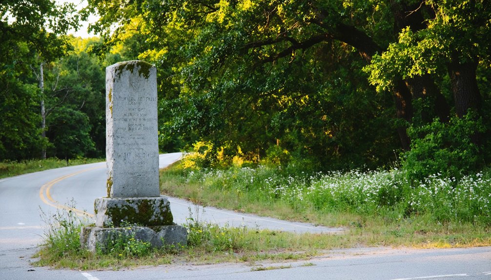
Finding Adamson’s memorial monument requires traversing a network of rural roads where the ghost town once thrived between McAlester and Wilburton. You’ll discover it on the Benedict Family property, just off Hartshorne-Adamson Road, standing as a record to the community’s coal mining heritage. The monument sits approximately 150 yards from where Mine No. 1’s entrance once operated, near Joe Benedict’s home.
Access this historical marker by heading east on Highway 31 from McAlester, then exiting onto Adamson Road. Monument photographs capture the weathered tribute to Peter Adamson and the 3,500 residents who once called this place home. While monument restoration efforts haven’t matched other ghost town sites, the marker remains visible among the rural landscape that Lake Eufaula’s extensions haven’t claimed.
Anthony Benedict’s Tribute Details
When you stand before the granite memorial marker off Hartshorne-Adamson Road, you’re witnessing a tribute born from one family’s determination to preserve a tragedy that claimed fourteen lives in 1914. Anthony Benedict‘s lasting impact echoes through generations—he escaped Mine No. 1 as the last man alive, watching his fellow miners’ hard hat lights extinguish one by one beneath collapsing earth. He left fourteen men 800 feet underground, their names now etched in donated granite.
Anthony Benedict’s familial connections sustained the memory: his son Joe welcomed visitors here for decades, retelling his father’s harrowing account until his death in 2011. The marker stands because Oklahoma’s chief mine inspector discovered no memorial existed in the 1960s, prompting locals to finally honor those Italian immigrant coal miners who’d been forgotten.
Former Farm Site Markers
The monument sits where corn once grew, tucked along a gravel stretch of Hartshorne-Adamson Road where prairie grass now reclaims what mining families left behind. You’ll spot the abandoned farmstead ruins about two miles past Hartshorne’s Orthodox cathedral—look for crumbling limestone foundations where immigrant miners grew vegetables between shifts underground. This historic agricultural landscape tells Oklahoma’s rawer truth: families carved out autonomy here before coal money changed everything.
Park at the roadside turnout where wild blackberries tangle through old fence posts. The memorial stone honors those who worked both farm and mine, refusing to depend solely on company scrip. Their self-sufficiency survives in these weathered markers. Bring boots—Oklahoma mud respects no monument visitor, and you’ll want traction exploring beyond the maintained path.
Best Times to Visit and What to Bring

Planning your ghost town adventure to Adamson requires consideration of Oklahoma’s temperamental weather and the unique challenges of exploring abandoned sites. While ideal visiting seasons lean toward spring and fall when temperatures hover between 60-75°F, you’ll need to prepare for whatever nature throws your way.
Essential packing recommendations for your exploration:
- Sturdy hiking boots – Navigate crumbling foundations and overgrown terrain near Eufaula Lake’s shoreline
- Weather-appropriate layers – Oklahoma’s climate shifts rapidly; pack rain gear and sun protection
- Navigation tools – GPS device and physical maps since cell service proves unreliable
- Emergency supplies – First aid kit, plenty of water, and flashlight for investigating deteriorated structures
Combining Your Trip With Nearby Ghost Towns
You can transform your Adamson visit into a proper Oklahoma mining heritage trail by mapping a route through Pittsburg County’s coal country, where Arpelar’s semi-abandoned remnants still cling to the hillsides just miles away. The Hartshorne-Adamson Road connects these sites naturally, letting you trace the rise and fall of the region’s extraction economy in a single afternoon.
Consider timing your trip when Eufaula Lake’s water levels drop in late summer—you’ll spot foundations and railroad grades that vanish beneath the surface during wetter months.
Oklahoma Ghost Town Circuit
Since Adamson sits within a region rich with abandoned settlements, your ghost town adventure can easily expand into a multi-day circuit through Oklahoma’s eeriest landscapes. You’ll discover Oklahoma’s hidden coal mine sites connecting perfectly with Adamson’s architectural ruins as your starting point.
Circuit Route Highlights:
- Osage County Loop – Navigate from Adamson northwest to Blackland (12 miles from Pawhuska), then push to Carter Nine (22 miles northwest) for windswept prairie vistas and crumbling foundations.
- Northern Corridor – Explore Kaw City’s submerged remains beneath Kaw Reservoir and Osage’s 1906 church structure still defying time.
- Central Triangle – Visit Keokuk Falls’ 1891 structures, Orlando’s ghost community, and Park Hill’s historic cemeteries dating to 1836.
- Southern Extension – End at Lake Texoma where Woodville vanished beneath the waters in the early 1940s.
Mining Heritage Trail Route
Oklahoma’s mining legacy transforms your ghost town expedition into a journey through the state’s gritty industrial past, where zinc and lead operations once fueled entire communities before leaving skeletal remains in their wake.
You’ll trace Route 66 from Quapaw—just four miles from Kansas—through Commerce and Miami to Vinita, following remnants of mining infrastructure that made fortunes in the early 1900s. Commerce’s population of 2,401 still celebrates Mickey Mantle’s boyhood, while Miami’s Spanish Revival Coleman Theater showcases wealth extracted from beneath red Oklahoma soil.
Mining town archives reveal how this hardscrabble region harbored 1920s gangsters seeking refuge. The Million Dollar Elm Tree once shaded oil baron Frank Phillips, representing northeastern Oklahoma’s boom-to-bust narrative. You’re free to explore these unguarded histories without entrance fees or restrictions.
Eufaula Lake Historical Sites
Where else can you explore a submerged ghost town while standing on the shoreline of Oklahoma’s largest lake? Lake Eufaula’s 600-mile shoreline conceals North Fork Town, a former Creek Nation crossroads that vanished beneath the waters when the dam flooded the valley in 1964.
Your historical trek around the lake reveals authentic freedom stories:
- Honey Springs Battlefield – Walk grounds where 9,000 troops clashed in Indian Territory’s largest Civil War engagement
- Eufaula Area Museum – Browse Muscogee (Creek) Nation sites artifacts and eufaula lake dam history exhibits (Saturdays 10-2, free)
- Choate Cabin – Meet pre-statehood leadership legacy in Indianola (call ahead: 773-844-1804)
- Three Rivers Museum – Explore Muskogee’s restored railroad depot connecting regional settlement patterns
Each stop connects you to vanished worlds worth remembering.
Other Historical Mining Attractions in Pittsburg County
The coal seams beneath Pittsburg County soaked the earth with blood long before Adamson’s final collapse. You’ll find memorials scattered across McAlester’s landscape—Chadick Park holds a mass grave for fifty-nine miners killed when methane ignited at Old Town Mine in 1929.
Savanna’s 1887 explosion claimed eighteen lives, while McCurtain’s 1912 blast killed seventy-three in a fifty-foot eruption of flame. The Wilburton disaster took ninety-one souls in 1926.
These catastrophes reveal why rehabilitation efforts for mining disaster sites remain minimal—there’s little funding when the impact on local economy from industry decline devastated entire communities. You’re free to explore these forgotten grounds where warning signs went unheeded and ventilation systems failed. The earth remembers what progress forgot.
Frequently Asked Questions
Are There Any Guided Tours Available for Adamson Ghost Town?
No guided tours are available for Adamson ghost town due to private property restrictions. You’ll need to explore independently, respecting boundaries and seeking permission from landowners. The freedom of self-discovery makes your adventure uniquely rewarding and personal.
Can You Scuba Dive to See Submerged Structures Under Eufaula Lake?
While North Fork Town sleeps beneath the waves, you won’t find guided scuba access to its structures. Diving conditions and underwater visibility at Eufaula Lake make exploring these submerged ruins impractical—they’re only visible during extreme low-water events.
Is Camping Allowed Near the Adamson Town Site?
No designated camping exists at Adamson itself, but you’ll find rustic campsites available at nearby state parks and Wildlife Management Areas. Primitive camping options require checking local regulations—Oklahoma’s 14-day limits and designated-site rules apply throughout the region.
Are There Any Safety Concerns When Exploring the Remaining Structures?
Absolutely—you’ll face unstable structures ready to collapse, toxic contamination in every surface, and potential sinkholes from mine subsidence. Trespassing concerns exist on private property, plus those spray-painted warnings aren’t decoration. Your freedom shouldn’t cost your life.
What Photography Restrictions Exist at the Cemetery and Memorial Monument?
You’ll find cemetery photography walks a tightrope between preservation and respect. Rules regarding photography typically prohibit commercial use without permission, while accessibility of off-limits areas remains restricted. Always check locally, avoid flash, and never disturb graves during your exploration.


