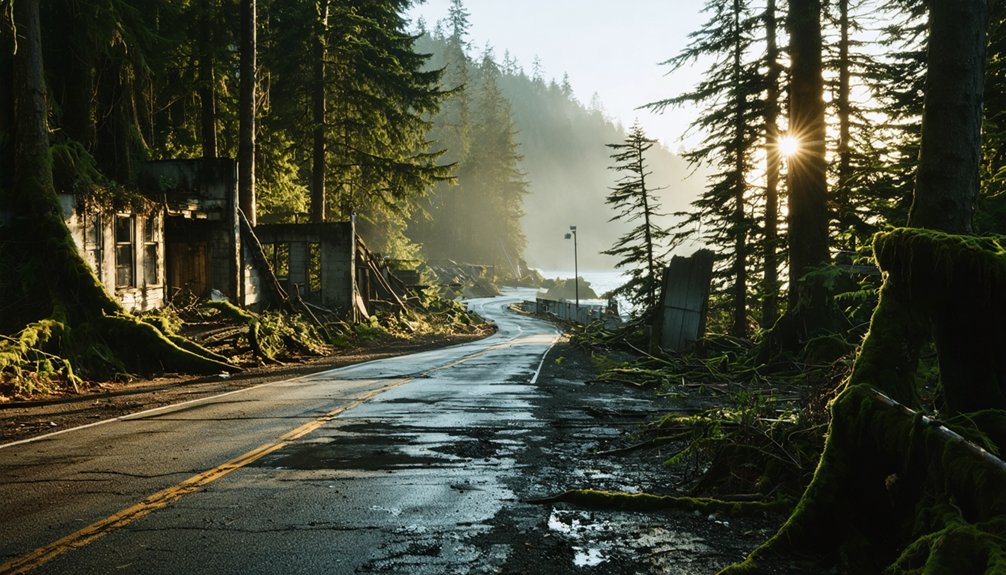
Planning a ghost town road trip to Bayocean, Oregon starts in Tillamook, just four miles from the peninsula. You’ll walk four miles of uncrowded Pacific shoreline where a 1,000-seat theater and grand natatorium once stood before coastal erosion swallowed them whole. Bring sturdy shoes, pack water, and stop at Tillamook Creamery before heading out. Nearby, Cape Meares Lighthouse and the Three Capes Scenic Route add even more to your adventure — and there’s a fascinating, cautionary story waiting to unfold.
Key Takeaways
- Bayocean Peninsula is located 4 miles from Tillamook, Oregon, at coordinates 45°31′39″N, 123°57′08″W, requiring no complex navigation.
- Start your trip at Tillamook Creamery for breakfast before exploring the former ghost town’s four miles of Pacific shoreline.
- No buildings, foundations, or streets remain, but the peninsula offers sweeping views of Tillamook Bay and the Pacific Ocean.
- Bring sturdy shoes and water, and walk the former ridgeline for historical perspectives of the ocean and bay.
- Combine your visit with nearby attractions, including Cape Meares Lighthouse and the Three Capes Scenic Route.
What Was Bayocean, Oregon’s Lost Resort Town?
Once dubbed the “Atlantic City of the West,” Bayocean was an ambitious resort town built on a 600-acre peninsula along Oregon’s Tillamook Bay, founded in 1906 by Thomas Benton Potter and his family.
This remarkable chapter in Bayocean history began with Potter aggressively marketing his vision across the Pacific Northwest, selling 600 lots by 1914 and attracting a population of 2,000 residents.
The resort development was genuinely impressive — you’d have found a 1,000-seat theater, a massive indoor natatorium, paved roads, a private railroad, and even electricity.
Potter promoted it as Oregon’s premier destination, and for a time, it delivered.
Unfortunately, financial troubles sent the venture into receivership by 1915, foreshadowing a far more dramatic collapse that nature itself would eventually deliver.
What Destroyed Bayocean and Sank It Into the Sea?
Although Bayocean’s financial troubles arrived first, it was nature — amplified by human engineering — that delivered the killing blow.
Jetty construction at Tillamook Bay’s north entrance, begun in 1914, fundamentally altered wave patterns along the spit. The erosion impact was immediate and devastating — storms in 1932, 1939, 1942, and 1948 systematically dismantled everything the Potters had built. The grand natatorium collapsed into the surf during the 1932 storm.
Jetty construction didn’t just reshape the coastline — it signed Bayocean’s death warrant, one devastating storm at a time.
A jetty extension in 1933 accelerated the spit’s deterioration further, breaching it entirely. By 1952, Bayocean had become an island. Desperate dike-building efforts in 1956 couldn’t reverse decades of destruction.
The last house surrendered to the ocean on February 15, 1960. What ambitious developers once proclaimed the “Queen of Oregon Resorts” had literally disappeared beneath the waves.
What’s Left to See at the Bayocean Ghost Town?
Despite the ocean’s thorough erasure of Bayocean’s built world, the peninsula itself survives — and it’s worth making the trip. Coastal erosion claimed every abandoned structure, leaving no buildings, foundations, or streets behind.
What you’ll find instead is raw, windswept beauty: four miles of uncrowded Pacific shoreline, sweeping views across Tillamook Bay, and the quiet ridgeline where a thriving resort town once stood.
Walk the trail to the peninsula’s edge and you’ll feel the history beneath your feet. The land itself tells the story — the reshaped beach, the formed Meares Lake, the embankment rebuilt after the reclamation effort.
Nature reclaimed everything here completely and unapologetically. For travelers craving open space and a genuinely haunting sense of place, Bayocean delivers something no preserved ghost town can replicate.
How Do You Get to Bayocean Peninsula?
Getting to Bayocean Peninsula is straightforward, though the drive itself sets the mood perfectly. From Tillamook, you’ll follow a 4-mile road that winds toward the peninsula, gradually trading town life for wild coastal scenery.
The access routes are simple — no complex navigation required, just open road leading to a place most travelers never discover.
No complex navigation, no crowds — just open road leading somewhere most travelers never think to look.
Once you arrive, you’ll park and continue on foot toward the site’s edge, where the former 140-foot ridgeline still offers sweeping views of both Tillamook Bay and the Pacific Ocean.
Keep these travel tips in mind: wear sturdy shoes, bring water, and check weather conditions before heading out.
The peninsula sits at 45°31′39″N, 123°57′08″W in Tillamook County — remote enough to feel like a genuine escape.
How Do You Plan a Trip to Bayocean Peninsula?
Once you know how to get there, planning the full trip pulls everything together.
Build your trip itinerary around Tillamook’s local attractions to maximize your time on the Oregon Coast. Start at the Tillamook Creamery for a hearty breakfast before driving the 4-mile road out to Bayocean Peninsula.
Walk the former ridgeline where a thriving resort town once stood, scanning both the ocean and bay from the same vantage point. Bring sturdy shoes, water, and a curiosity for layered history.
Nearby, the Cape Meares Lighthouse and Three Capes Scenic Route offer stunning coastal detours worth adding.
Whether you’re chasing ghost town history or open-air freedom, Bayocean delivers a rare combination of natural beauty and fascinating, forgotten American ambition.
Frequently Asked Questions
Who Were the First Lot Buyers at Bayocean in 1907?
Francis Drake Mitchell claimed the title of Bayocean’s first historic investors, purchasing lots in 1907. You’d be stepping into coastal development history by exploring where these pioneering buyers helped shape Oregon’s once-thriving resort destination.
What Native Traditions Exist About Bayocean Spit’s Geological History?
Like shifting sand beneath restless tides, Native legends warned you that Bayocean Spit’s geological significance shouldn’t be ignored—they’d always known this unstable ground had previously existed as an island, forever shaped by nature’s untameable, boundless forces.
When Did Bayocean Officially Go Into Financial Receivership?
You’ll find that Bayocean’s financial decline hit hard in 1915, when it officially entered receivership. The economic impact was devastating, crushing dreams of the “Queen of Oregon Resorts” and leaving this once-thriving community financially broken and abandoned.
What Happened to Bayocean’s Elementary School Students After 1947?
The world turned upside down for those kids! After 1947, you’d witness a massive student relocation, as the elementary school moved to Cape Meares, creating an unforgettable educational impact on Bayocean’s shrinking, erosion-battered community.
How Did the 1956 Dike Project Reshape the Surrounding Landscape?
You’ll find that the 1956 dike project dramatically reversed coastal erosion through bold land reclamation efforts—crews bulldozed, burned, and buried buildings, rebuilt the peninsula east of its original site, and formed scenic Meares Lake between the new beach and breakwater.
References
- https://en.wikipedia.org/wiki/Bayocean
- https://www.oregonencyclopedia.org/articles/bayocean/
- https://www.opb.org/news/article/oregon-bayocean-ghost-town-resort-tillamook-bay/
- https://www.bayocean.net/p/the-bayocean-story-in-brief.html
- https://www.youtube.com/watch?v=dl4MeF5pTOw
- https://www.youtube.com/watch?v=MMKOg2IWES4


