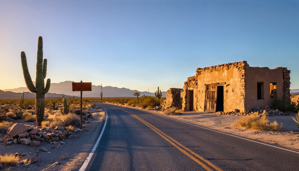
Planning a ghost town road trip to Ehrenberg, Arizona means stepping back into a Colorado River boomtown that thrived for nearly 50 years before fading into silence by 1915. You’ll explore weathered graves at Pioneer Cemetery, crumbling adobe ruins, and a historic steamboat landing—all on open BLM land with no admission fees or crowds. It’s an easy stop just off I-10, close to the California border, and there’s far more history waiting ahead.
Key Takeaways
- Ehrenberg, Arizona, a ghost town since 1915, offers history buffs adobe ruins, a pioneer cemetery, and Colorado River views worth exploring.
- Access Ehrenberg easily via I-10, near the Arizona-California border, using the Flying J truck stop exit as your landmark.
- Explore the Pioneer Cemetery, old steamboat landing, adobe ruins, and historic ferry crossing site without admission fees or crowds.
- Free dispersed BLM camping and the Ehrenberg/Parker KOA provide convenient overnight options for road trippers visiting the area.
- Extend your ghost town road trip by visiting nearby Vulture City and Congress, both rich in Arizona’s mining history.
Ehrenberg’s 50-Year Rise From Gold Rush Crossroads to Ghost Town
When Herman Ehrenberg staked his claim on the Colorado River desert in 1863, he wasn’t just founding a town — he was planting a crossroads at the edge of the American frontier. Born from the La Paz gold rush, this mud-house pueblo quickly became something bigger than a mining camp.
Steamboats docked here. Stagecoaches rolled through. U.S. Army soldiers, Cocopah traders, California freighters, and desert prospectors all passed through its dusty streets. For nearly 50 years, Ehrenberg served as Northwestern Arizona’s beating commercial heart.
Then the 1907 Laguna Dam silenced the river traffic overnight, and the town’s historical significance faded with it. By 1915, Ehrenberg was abandoned — a ghost town swallowed by desert brush, its remarkable run largely forgotten.
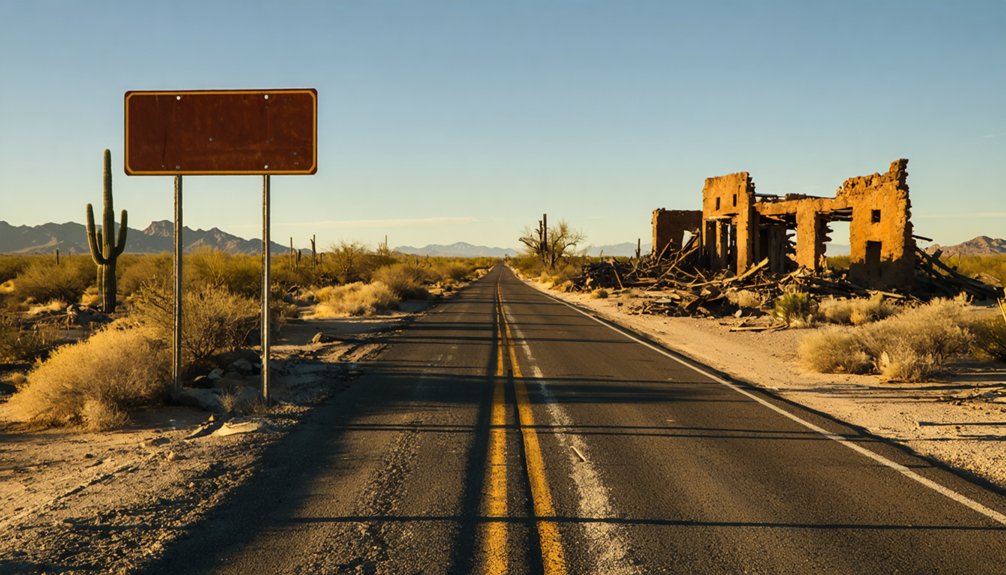
What Draws Road Trippers to Ehrenberg’s Colorado River Ruins Today
Despite Ehrenberg’s quiet collapse more than a century ago, something about its ruins still pulls road trippers off I-10 today.
The ghost town allure is real — stone-covered graves in the Pioneer Cemetery, crumbling adobe walls, and tangled Colorado River underbrush hiding what was once a thriving Southwest crossroads.
Stone-covered graves, crumbling adobe, and river underbrush hiding the bones of a forgotten Southwest crossroads.
You can explore freely here. Bring a drone and capture sweeping river views.
Walk the same desert ground where Cocopah and Mohave traders once bartered hides and gold nuggets. Stand near the old steamboat landing and feel the weight of Ehrenberg history beneath your boots.
There’s no admission gate, no crowds, no schedule. Just open BLM land, a forgotten town, and the kind of raw, unfiltered American history that makes detours worth taking.
How to Get to Ehrenberg, Arizona
Getting to Ehrenberg is straightforward if you’re coming from the east on I-10—take the exit near the Arizona-California state line, where you’ll spot a Flying J truck stop and a 76 gas station marking your turn.
You’ll find yourself just 10 miles from the California border, with BLM camping and state trust land flanking the route as you head toward the Colorado River.
Once you’ve passed the RV resorts and the tiny farming community remnants, you’re standing at the same desert crossroads where the Bradshaw Trail, the La Paz-Wickenburg Road, and the Mojave Road once converged.
Driving Routes And Access
Tucked along the Colorado River near the California border, Ehrenberg sits just off I-10, making it a straightforward detour whether you’re cutting through the desert Southwest or hunting ghost towns along the river corridor.
From Quartzsite, head west on I-10 and watch for the Ehrenberg exit — you’ll spot the Flying J truck stop and a 76 station signaling your turn.
Among driving tips worth knowing: the roads flatten into open desert stretches that reward slow travel and scanning the horizon.
For scenic routes, the La Paz-Wickenburg Road offers raw Sonoran Desert character if you’re coming from the east.
California sits roughly ten miles beyond, so you can easily pair this stop with cross-border wandering along the lower Colorado corridor.
Nearby Landmarks And Exits
Finding Ehrenberg is straightforward once you know what to look for along I-10. Heading west from Quartzsite, watch for the Ehrenberg exit near the California state line, roughly 10 miles out. You’ll spot a Flying J truck stop and a 76 gas station — practical pit stops before you explore.
The exit drops you into a tiny farming community hugging the Colorado River, where nearby attractions include BLM camping grounds and sprawling RV resorts that make extended stays easy.
The landmark history here runs deep — this stretch of desert once connected Bradshaw Trail, the Mojave Road, and the La Paz-Wickenburg Road into a single crucial crossroads. Those same dusty routes that freighters and prospectors traveled are now your gateway into Ehrenberg’s forgotten past.
What to See at the Ehrenberg Pioneer Cemetery
One of Ehrenberg’s most compelling stops is the Pioneer Cemetery, where stone-covered graves dot the sun-baked desert floor like a scene lifted straight from an Old West film set.
The cemetery history stretches back to 1862, and the grave markers tell silent stories of miners, traders, and frontier survivors.
Here’s what you’ll find when you explore:
- Weathered grave markers half-swallowed by desert brush
- Stone-covered burial mounds preserved by dry desert air
- Remnants of iron fencing marking family plots
- Inscriptions honoring miners lost during the La Paz gold rush
- Sweeping Colorado River views framing the entire site
Walk slowly, read what’s legible, and let the weight of the place settle in.
This ground holds real Arizona history, completely unfiltered and entirely free to explore.
Steamboat Landing, Adobe Ruins, and What Survives Along the River
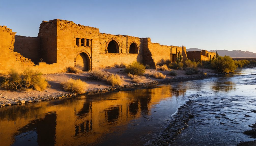
Beyond the cemetery, the Colorado River quietly erases what the desert hasn’t already claimed.
You’ll find scattered adobe ruins where merchants, soldiers, and prospectors once built their lives along this stretch of water. The steamboat history here runs deep — sternwheel boats once docked regularly, ferrying supplies and fortune-seekers until the 1907 Laguna Dam ended river navigation for good.
What survives is fragmentary but powerful. Crumbling adobe architecture hints at the town’s mud-brick construction, typical of Colorado River desert settlements.
The old ferry crossing site sits somewhere beneath the overgrowth, reclaimed by brush and time. You’re walking ground where Cocopah and Mohave traders, California freighters, and Arizona-bound settlers all converged.
Bring water, wear sturdy boots, and let the ruins tell you what the history books only partially capture.
Where to Camp and Stay Near Ehrenberg
Camping options around Ehrenberg run the spectrum from full-hookup RV resorts to raw BLM desert, so you can tailor the stay to your setup. RV parks line the highway with amenities, while open land lets you drop anchor on your terms.
- Ehrenberg/Parker KOA – Full hookups, showers, Wi-Fi close to the I-10 exit
- BLM desert land – Free dispersed camping on state trust land west of town
- Colorado River sites – Primitive spots with direct water access and wide skies
- Flying J/truck stop area – Overnight parking for those passing through quickly
- Parker Strip (15 miles north) – Developed campgrounds with river recreation if you want neighbors
Pick your comfort level and claim your patch of Sonoran desert.
Arizona Ghost Towns Worth Combining With an Ehrenberg Visit
With your base camp sorted, it’s worth knowing that Ehrenberg sits at the edge of some genuinely rich ghost town country — and a few hours of driving puts you inside Arizona’s most compelling abandoned settlements.
Vulture City near Wickenburg rewards serious ghost town photography with intact structures and brutal mining history stretching back to the 1860s.
Vulture City delivers intact ruins and gritty 1860s mining history that serious ghost town photographers won’t want to miss.
Congress, another mining ruin northwest of Phoenix, offers crumbling headframes and quiet desert solitude.
Fairbank, down near Tombstone, preserves adobe ruins along the San Pedro River with BLM oversight similar to Ehrenberg’s situation.
Each stop deepens your understanding of how Arizona’s mining history shaped the entire Southwest.
String these towns together deliberately, and you’ve built a road trip that actually means something beyond scenery.
Frequently Asked Questions
Is Ehrenberg, Arizona Open to Visitors Year-Round?
You can visit Ehrenberg year-round! Explore its rich Ehrenberg history anytime, from the pioneer cemetery to Colorado River ruins. For visitor tips, pack water, embrace the open desert freedom, and enjoy drone-friendly skies above this untamed ghost town.
Are Drones Legally Permitted to Fly Over Ehrenberg’s Ghost Town Ruins?
You’ll capture a million breathtaking shots with drone regulations being fairly friendly here! The site’s drone-friendly terrain lets you soar freely, making ghost town photography an absolute dream over Ehrenberg’s hauntingly beautiful Colorado River ruins.
Who Was Herman Ehrenberg Before Founding This Arizona Ghost Town?
Before founding this Arizona town, you’ll discover Herman Ehrenberg’s Ehrenberg history as a roving mining engineer and Texas independence hero — a fearless freedom-seeker whose mining legacy helped shape the untamed Southwest frontier.
Is There an Entrance Fee to Explore the Ehrenberg Ghost Town?
You don’t need to pay an entrance fee to explore Ehrenberg’s ghost town history! You’re free to wander the Ehrenberg attractions, discovering pioneer graves and steamboat remnants along the Colorado River’s hauntingly beautiful, untamed desert landscape.
What Native American Tribes Historically Traded in Ehrenberg’s Stores?
Once a bustling crossroads, now silent ruins — you’ll discover the Cocopah, Mohave, and Yuma tribes drove Ehrenberg’s trading practices, bringing hides, mesquite beans, and placer nuggets, creating rich cultural exchanges within its storefronts and saloons.
References
- https://www.arizonahighways.com/archive/issues/chapter/Doc.101.Chapter.3
- https://www.atlasobscura.com/things-to-do/arizona/ghost-towns
- https://www.youtube.com/watch?v=bqEvmUNaCog
- https://southernarizonaguide.com/three-days-touring-se-az-fantastic-country/
- https://www.youtube.com/watch?v=8Md93NQUJxc
- https://en.wikipedia.org/wiki/List_of_ghost_towns_in_Arizona


