Plan your Bighorn ghost town road trip between late April and October when routes remain passable and temperatures hover comfortably between 57-88°F. You’ll navigate 60-70 mile stretches without services, so fuel up in Lovell before exploring Ewing Ghost Ranch‘s 1890s homestead or venturing toward Elkhorn’s preserved silver boom structures. Pack navigation tools, layered clothing for temperature swings, and emergency water supplies—cell service vanishes in Montana’s backcountry. The region’s abandoned settlements, from failed gold rush camps to frontier ranches, reward those who prepare properly for remote exploration.
Key Takeaways
- Visit during summer (82-88°F) or fall (59°F) for optimal conditions; winter’s 45 inches of snow closes most routes.
- Bring printed coordinates, satellite communicator, and offline maps since cell service is nonexistent in Elkhorn Mountains backcountry.
- Pack one gallon of water per person daily, purification tablets, and 72-hour emergency reserves for remote areas.
- Plan for 60-70 mile stretches without services along U.S. 20/287; fuel up and prepare for wildlife encounters.
- Stay on established trails, photograph without touching structures, and pack out all trash to preserve sites.
Understanding the Bighorn Canyon National Recreation Area
The Bighorn Canyon National Recreation Area sprawls across 120,000 acres where the Montana-Wyoming border cuts through some of the West’s most dramatic terrain. You’ll find yourself standing at the edge of cliffs plunging 2,500 feet into Bighorn Lake, a 71-mile ribbon of water carved by the Yellowtail Dam.
The geography and geology here tell 10,000 years of human history through pictographs and petroglyphs etched into canyon walls, while Upper Jurassic fossils emerge from ancient rock layers.
The regional plant and animal life thrives across desert shrubland, juniper woodland, and sagebrush steppe. Wild horses roam freely alongside bighorn sheep, while over 200 bird species—including bald eagles and pelicans—patrol the skies. You’re entering country where mountain lions still hunt and bears still wander. The area serves as critical wildlife migration corridors connecting ecosystems across the northern Rockies.
The recreation area offers various recreational activities including hiking trails that wind through the canyon, fishing in Bighorn Lake’s pristine waters, and boating opportunities along the reservoir’s extensive shoreline.
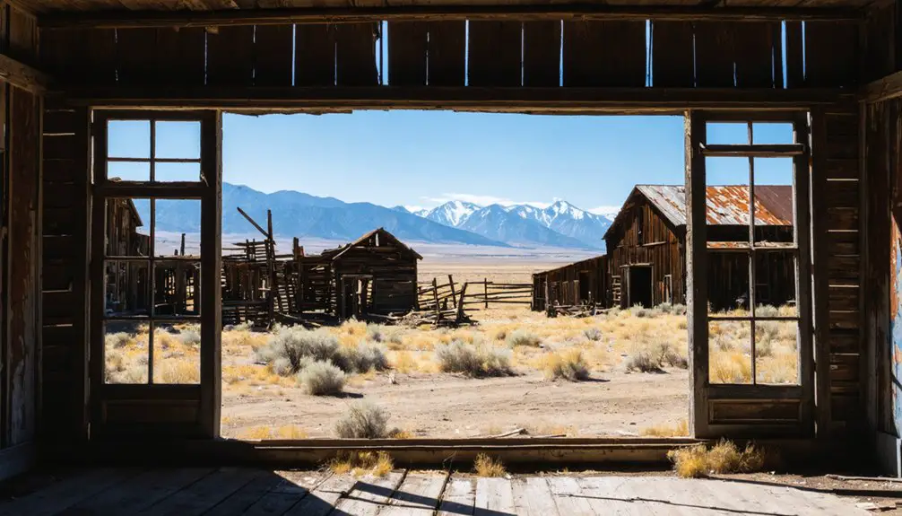
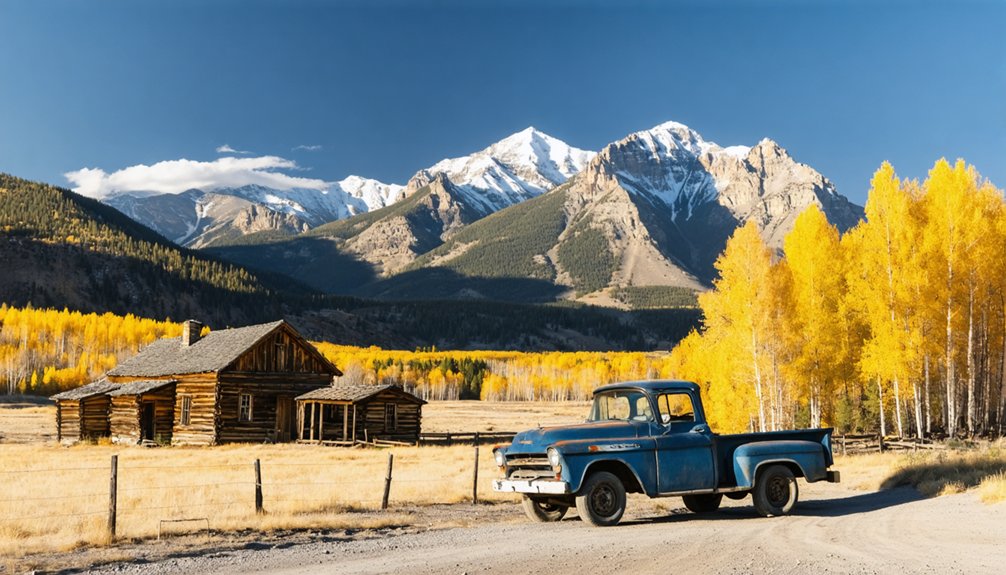
Ewing Ghost Ranch: A Preserved Frontier Homestead
North of Lovell, Wyoming, where Layout Creek threads through Dryhead Country, you’ll discover the Ewing Ghost Ranch clinging to a bench above the Bighorn Canyon‘s western wall. Erastus T. Ewing staked his claim here between 1896 and 1898, trading gold dreams for irrigation ditches and survival. His one-story hipped-roof house still stands, remodeled as seasonal ranger quarters but closed to interpretation—preserved ranch artifacts remain visible throughout the property.
The stables, outbuildings, and old Dryhead School building create an authentic frontier tableau against the Pryor Mountains. This area holds ancestral native significance long predating Ewing’s arrival during Montana’s gold rush. The property operated as Ewing, Montana post office from 1898 to 1906, serving the isolated ranching community. Listed on the National Register since 1977, the ranch offers parking, trails, and vault restrooms. His grave rests a quarter-mile north—a solitary marker in unforgiving country.
The U.S. Government acquired the property in 1968 for inclusion in the Bighorn Canyon National Recreation Area, ending decades of private ownership by the Snell family who had lived there the longest.
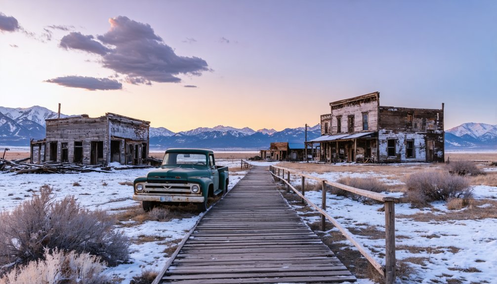
Hillsboro: The Failed Gold Rush Settlement
When Granville and James Stuart struck gold at Gold Creek in spring 1858—east of present-day Drummond in western Montana’s rugged terrain—they ignited Montana’s first significant gold rush and inadvertently planted seeds for countless failed settlements like Hillsboro. Though the Stuarts’ publicity letter sparked nationwide migration, settlement patterns proved brutally unforgiving.
Hillsboro exemplified the transient population phenomenon:
- Miners staked claims rapidly, erected crude shelters, then vanished when richer strikes emerged at Grasshopper Creek in 1862
- Back-breaking placer mining demanded moving massive dirt piles through creek beds for diminishing returns
- By late 1870s, 500 gulches hosted temporary camps—most died within years
Montana’s boom-and-bust cycle left ghost towns scattered across western valleys. As copper mining gained prominence towards the end of the 19th century, gold took a backseat and accelerated the abandonment of struggling settlements. These rough camps gradually added schools, churches, and theaters before their eventual decline. You’ll find little remaining of Hillsboro today—just another forgotten chapter in Montana’s treasure-hunting legacy.
Big Horn Medicine Wheel: Sacred Ancient Site
Perched at 9,642 feet on Medicine Mountain’s windswept ridge, the Big Horn Medicine Wheel sprawls across limestone bedrock like an ancient cosmic map etched in stone. You’ll find 28 radial spokes connecting a central cairn to an 82-foot circle rimmed with white limestone—one of North America’s largest sacred wheels.
The Crow call it Annáshisee, “Large campsite,” and multiple nations still conduct ceremonies here. Archaeological preservation efforts protect this 4,080-acre landmark, where trails used for 10,000 years converge at 9,642 feet elevation. Astronomer John Eddy discovered the wheel’s alignments with summer solstice sunrise and sunset, along with the rising points of significant stars. If you encounter a private ceremony in progress, observe quietly from a distance and refrain from taking photographs.
Access runs mid-June through mid-September from Lovell (25 miles west) or Sheridan (46 miles east). Winter snows seal the site eight months yearly, preserving its Native American significance and remote sanctity. Come prepared—altitude and isolation demand respect.
Elkhorn Ghost Town: Montana’s Silver Mining Legacy
While sacred sites mark spiritual journeys across Montana’s peaks, the state’s ghost towns tell earthier stories of fortune and loss.
Elkhorn’s silver boom began when Peter Wys discovered galena ore in 1870. By the 1890s, you’d have found 2,500 residents building lives around mining operations that extracted $14 million in silver. The town thrived until 1893’s silver crash triggered a catastrophic town population decline—75% vanished within two months.
Today, you’ll discover:
- Fraternity Hall and Gillian Hall, stabilized remnants of frontier prosperity
- Elkhorn State Park preserving silver-era architecture
- Evidence of 800-foot mine shafts that once produced 8.9 million ounces of silver
- A family-oriented ghost town atmosphere, rare among Western mining camps
Summer cottage residents still maintain this haunting landscape where fortune-seekers once chased freedom underground. The Northern Pacific Railroad built a spur line to Elkhorn in 1889, which proved vital for ore transportation and helped sustain the town even after silver prices collapsed. Anton M. Holter established the Holter Lode in 1875, creating the first silver mine that transformed Elkhorn from a prospector’s claim into a legitimate mining town.
Essential Route Planning and Road Conditions
Traversing Montana’s ghost town circuit requires strategic planning—these weathered settlements don’t cluster conveniently along interstate corridors. Bannack demands a 21-mile westward detour from I-15 via Montana Highway 278, while Garnet sits 11 miles north of Highway 200 on Garnet Range Road. You’ll navigate gravel stretches and seasonal closures, particularly on mountain passes requiring verification through Montana’s transportation department.
Fog frequently obscures visibility at higher elevations, and those 60-70 mile no-services routes along U.S. 20/287 demand advance fuel planning at Island Park. Parking lot conditions vary from maintained gravel to rutted dirt—expect the primitive.
Wildlife encounters intensify your adventure: Pryor Mountain’s wild horses roam near Bighorn Canyon, while elk and deer cross backcountry roads without warning. Winter transforms accessible routes into impassable snowfields.
Best Times to Visit the Bighorn Region
Timing your Bighorn ghost town expedition transforms weather from adversary to ally. Summer delivers 82-88°F days with minimal rainfall and 206 sunny days annually—perfect for extended exploration along dusty mining roads. Yet shoulder season visitation in spring and fall offers compelling advantages you shouldn’t overlook.
Summer’s 206 sunny days invite exploration, but spring and fall’s moderate temperatures offer ghost town adventurers distinct strategic advantages worth serious consideration.
Consider these seasonal opportunities:
- Late April-June: Snowmelt swells rivers while 57°F temperatures prevent heat exhaustion on remote trails
- September-October: Ideal hiking conditions with 59°F highs, vibrant foliage, and post-summer solitude
- July-August: Maximum daylight hours for photography, though temperatures can spike above 100°F
- Winter access: Expect 45 inches of snow and frequent road closures limiting ghost town access
The region’s semi-arid climate means you’ll encounter minimal precipitation interference—just 14 inches annually compared to the national 38-inch average.
What to Bring for Remote Ghost Town Exploration
The isolation of Bighorn demands self-sufficiency—you’ll need detailed topographic maps and a GPS device loaded with offline data, since cell service vanishes miles before you reach the townsite.
Montana’s high-altitude weather shifts violently, so pack base layers, an insulated jacket, and rain gear even during summer months.
Your emergency kit should include at least two liters of water per person, an extensive first-aid supply, and enough food to outlast an unexpected overnight stay if vehicle trouble strands you.
Traversing Montana’s ghost towns demands old-school preparedness—digital tools fail when you’re eleven miles up a gravel switchback with no cell signal. Pack detailed maps like the Southwest Montana Ghost Towns printable showing Bear Gulch Road’s steep ascent to Garnet at 6,000 feet. Digital trail guides work until they don’t—download offline versions before leaving Boulder or Drummond.
Your navigation arsenal should include:
- Printed coordinates: Elkhorn (46.27514/-111.94619), Coloma (46°50′35″N 113°22′50″W)
- Satellite communicator: Cell towers vanish in Elkhorn Mountains backcountry
- Park entrance maps: Elkhorn State Park distributes free guides at 812 Elkhorn St
- Compass and backup battery pack: When GPS quits on Garnet Range Road’s 13-mile loop
Trust paper when technology abandons you in Montana’s remote mining districts.
Weather-Appropriate Clothing Layers
Montana’s ghost towns punish wardrobe mistakes—hundred-degree July afternoons at Bighorn Canyon plummet to fifty-degree nights that’ll leave you shivering beside a campfire if you’ve packed wrong.
Start with moisture wicking fabrics against your skin: merino wool or synthetics that regulate temperature when you’re scrambling through abandoned buildings. Layer a fleece mid-weight over that, something you can shed when exploring sun-baked structures. Your outer shell needs windproof protection—those 20 mph gusts cut through everything else.
Pack adjustable insulation layers you can strip down or pile on. January visits demand serious gear when temperatures drop below zero, but September’s eighty-degree days collapse to thirties overnight. Toss in a waterproof jacket for Montana’s unpredictable weather. The desert rain shadow won’t soak you often, but when storms hit these canyons, you’ll need protection fast.
Emergency Supplies and Water
When did you last check your water supply before heading into abandoned territory where the nearest gas station sits forty miles behind locked gates? Bighorn’s crumbling structures won’t offer hydration—you’ll need one gallon per person daily, minimum. Pack collapsible containers and hydration bladders that won’t consume precious cargo space.
Essential water purification methods for self-reliant exploration:
- Ferrocerium rod and stainless pot for boiling questionable creek water
- Purification tablets that neutralize bacteria in minutes
- Portable filtration system for treating discovered springs
- Collapsible jerrycans for storing extra drinking water
Your 72-hour reserve isn’t paranoia—it’s survival arithmetic. Those weathered storefronts and silent streets demand respect through preparation.
Fire-starting tools double as purification backup when filters fail. Freedom means carrying responsibility in measured gallons.
Combining Multiple Sites Into One Loop Trip
A well-planned loop through south-central Montana stitches together four distinct ghost sites within a manageable 100-150 mile circuit, creating a full day’s exploration that maximizes your windshield time. Start at Bighorn’s mining remnants, then push eastward into Bighorn Canyon National Recreation Area where Hillsboro’s eight preserved dude ranch structures await documentation.
Coordinating site visitation efficiently means hitting Ewing’s ghost ranch while you’re already within the recreation area—don’t backtrack unnecessarily. From there, diversifying route options takes you northwest through Carbon County to Junction City’s elevated mining coordinates, then southward via Sheep Mountain Road to complete the circuit.
You’ll traverse gravel stretches requiring high-clearance vehicles, but that’s the price of accessing Montana’s authentic backcountry. Budget four to six hours driving, plus exploration stops.
Photography and Preservation Guidelines at Historic Sites
You’ll want to capture Bighorn’s weathered facades and rusty remnants, but remember these structures survive only through visitor restraint. Set up your tripod carefully to avoid disturbing loose boards or crumbling walls, and resist the urge to “improve” a shot by moving artifacts or climbing on fragile buildings.
Leave everything exactly as you found it—the next photographer deserves the same authentic scene you discovered.
Respectful Photography at Ruins
Before you raise your camera to capture Bighorn’s weathered structures, understand that photographing these ruins demands both technical skill and archival responsibility.
Your non flash photography techniques honor both the fragile materials and the site’s integrity. Use natural light and yellow filters to clarify architectural details through Montana’s haze. Cultural sensitivity awareness means documenting, not exploiting—these remnants represent real lives and lost communities.
Essential practices for capturing Bighorn:
- Handle equipment with clean hands; support cameras with both hands to prevent damage
- Include scale references in shots to convey the true dimensions of collapsing structures
- Document all visible elevations and architectural features systematically
- Store images properly at 30-50% humidity, away from direct sunlight
You’re creating historical records, not just vacation snapshots. Photograph responsibly.
Leave No Trace Principles
Capturing Bighorn’s crumbling facades on camera is only half your responsibility—the other half happens when you lower the lens and walk among the ruins. You’ll preserve this ghost town by keeping your hands off weathered timber and sun-bleached artifacts. Your skin’s oils accelerate decay on irreplaceable materials, so let your eyes do the exploring.
Pack out everything you brought in—every wrapper, every scrap. Stick to established paths threading between structures, even when mud tempts you to sidestep. These Leave No Trace principles parallel wildlife conservation efforts: minimal human interference protects what’s irreplaceable.
Historical preservation depends on visitors like you choosing documentation over collection, observation over interaction. The freedom to explore these abandoned places comes with the duty to leave them undisturbed for whoever follows your tracks tomorrow.
Protecting Fragile Historic Structures
Every click of your camera shutter at Bighorn carries weight beyond the photograph itself—it’s documentation that could one day help restore what time and weather are slowly erasing. Your photographic choices directly impact preservation efforts.
Smart documentation practices include:
- Obtaining landowner permission before photographing structures on private property
- Avoiding flash photography inside deteriorated buildings where light can damage fragile materials
- Staying outside roofless or partially demolished structures to prevent accelerating their collapse
- Never touching boarded-up walls or abandoned frameworks that might crumble under pressure
Your restraint matters here. Those weathered timbers and sagging doorframes survived a century of Montana winters—they’ll endure longer if you respect their boundaries. Document from respectful distances, leaving locked buildings undisturbed and posted warnings heeded.
Frequently Asked Questions
Are There Any Lodging or Camping Options Near the Ghost Town Sites?
You’ll find nearby bed and breakfasts and lodge rooms starting around $80 per night near Bighorn’s ghost town sites. Check seasonal campsite openings for more rustic stays. Several options offer that independent spirit you’re craving while exploring Montana’s forgotten places.
Do I Need Permits to Visit These Historic Locations?
You’re in luck—no permits needed for most ghost town visits. However, watch for private land ownership signs and access restrictions that could limit your exploration. Always respect posted boundaries while discovering Montana’s authentic, untamed frontier history freely.
Are These Ghost Towns Suitable for Children and Families?
Yes, these ghost towns offer family friendly activities perfect for all ages. You’ll discover schoolhouses, saloons, and dance halls where kids explore historical significance firsthand. Wide trails, picnic areas, and interpretive displays make learning adventures accessible and memorable for everyone.
What Wildlife Might I Encounter in the Bighorn Region?
You’ll discover over 40 mammal species roaming free here. Expect sightings of bighorn sheep traversing canyon walls and the presence of pronghorn antelope sprinting across open plains at 55 mph—pure wilderness awaits your exploration.
Are Guided Tours Available for Any of These Sites?
You’ll find guided tours offered by local historical societies throughout Montana’s ghost towns, plus self-guided walking tours around the ghost town sites. Apsaalooke Tours and Crow tribal guides provide authentic perspectives, though availability varies seasonally across different locations.
References
- https://www.legendsofamerica.com/ewing-montana/
- https://www.youtube.com/watch?v=J38tAc_Z5rw
- https://www.montanaoutdoor.com/2024/12/montanas-tiny-ghost-town-with-big-history/
- https://newprairiepress.org/cgi/viewcontent.cgi?article=1368&context=oz
- https://photoseek.com/2011/usa-montana-ghost-towns-history/
- https://glaciermt.com/ghost-towns
- https://www.distinctlymontana.com/curious-afterlife-montanas-ghost-towns
- https://www.nps.gov/bica/learn/historyculture/hillsboro.htm
- https://www.nps.gov/bica/learn/management/statistics.htm
- https://storymaps.arcgis.com/stories/e485867eee5b4c6687ceb9dfdb4e7c82