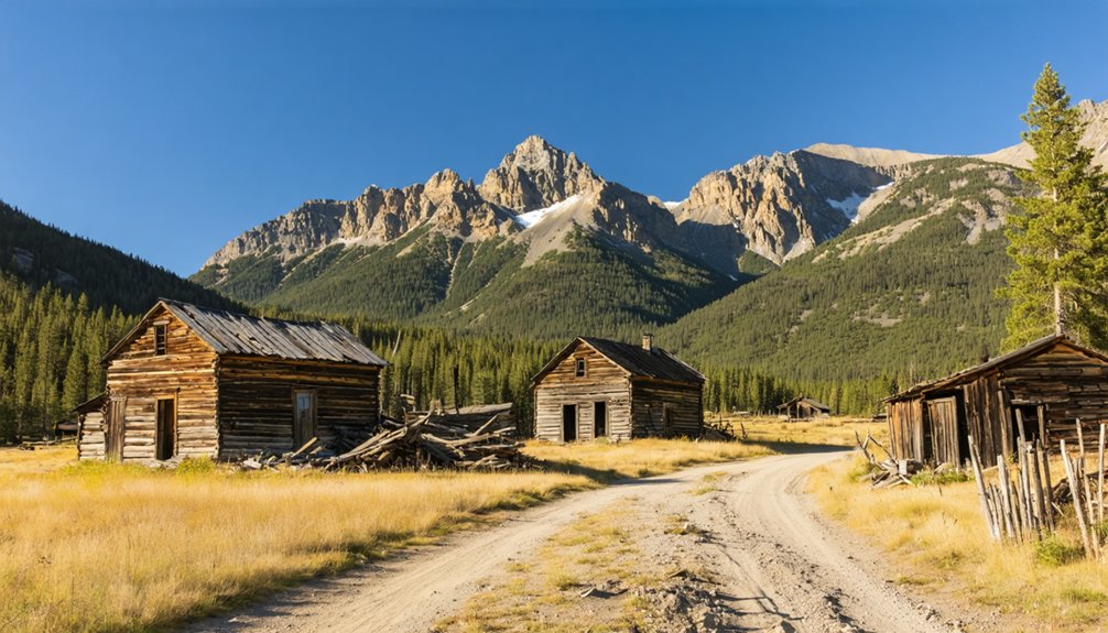
You’ll find Boreas Ghost Town perched at 11,481 feet on Colorado’s Continental Divide, accessible via Boreas Pass Road during summer months. This 1882 railroad settlement anchors a cluster of four high-altitude ghost towns—Argentine, Farnham, Farnham Spur, and Dwyer—all connected by the historic Denver South Park & Pacific Railroad route. You can explore restored structures including North America’s highest narrow-gauge station and even rent the section house for overnight stays. The road transforms into backcountry skiing terrain come winter, while summer visitors discover phenomenal wildflowers and mining remnants scattered across these remote peaks.
Key Takeaways
- Boreas sits at 11,481 feet on the Continental Divide, established in 1882 as one of Colorado’s highest ghost towns.
- Visit four ghost towns along Boreas Pass: Argentine, Farnham, Farnham Spur, and Dwyer, each with unique historic remnants.
- Must-see attractions include the highest narrow-gauge railroad station, restored Baker water tank, and aerial tramway skeleton.
- Boreas Pass Road is open during summer for cars and bikes, closed in winter for snowshoeing and backcountry skiing.
- The route follows the historic Denver South Park & Pacific Railroad, which crossed the Continental Divide twice.
Boreas Ghost Town: Colorado’s Sky-High Railroad Settlement
Perched at 11,481 feet on Colorado’s Continental Divide, Boreas stands as one of the highest ghost towns you’ll ever visit—a windswept memorial to the audacity of railroad workers who carved civilization into these unforgiving mountains. The Union Pacific Railroad pushed tracks through here in 1882, transforming an ancient indigenous migration route into the nation’s highest narrow-gauge railway.
Colorado’s 19th century economy demanded such engineering feats—mining operations required reliable supply lines, and Boreas delivered. At its peak, 150 souls weathered brutal winters in this purpose-built settlement, complete with post offices and a massive 57-by-155-foot engine house. Severe winters in 1898-99 stopped trains from running for months at a time, demonstrating the extreme conditions railroad workers endured.
Frontier era town planning meant simple practicality: structures designed purely for survival and railroad maintenance. The post office closed in 1905, marking the beginning of the settlement’s gradual decline. Today, you’ll find restored buildings along a gravel road that’s yours to explore each summer.
The Historic Denver South Park & Pacific Railroad Route
When the Denver South Park & Pacific Railroad punched its first tracks westward in July 1873, it launched what would become Colorado’s most vertically ambitious railroad venture—a iron-and-timber assault on geography that defied every reasonable engineering constraint.
You’ll trace a route that conquered Kenosha Pass by 1879, then clawed its way to Como through Platte Canyon’s granite walls. The route geography demanded crossing the Continental Divide twice—first at Boreas Pass (11,481 feet, America’s highest rail station) and again entering Summit County. Engineering challenges multiplied as crews blasted through Alpine Tunnel and scaled Trout Creek Pass. The Alpine Tunnel, at an elevation of 11,612 feet, became the highest railroad tunnel in North America during its operation. The narrow gauge railway operated for nearly six decades before the final passenger train ran in 1937.
Four Ghost Towns Along Boreas Pass Worth Exploring
The railroad’s ambitious climb over Boreas Pass left behind more than rusted rails and rotting ties—it scattered four ghost towns across the mountainside, each one frozen at a different stage of decay. You’ll find Argentine at 11,197 feet, where 18 buildings once housed miners and their only burial ground.
Farnham offers easiest access along Boreas Pass Road, with snow fence remnants and W.H. Farnham‘s 16-room “respiratory health” resort foundations. The real prize sits at Farnham Spur—a mile-long aerial tramway skeleton from Mt. Baldy, plus one intact outhouse hiding 200 feet into the trees.
Dwyer rounds out your exploration at 11,104 feet, where a population fluctuating between 20-40 people worked primarily in copper production. Mining infrastructure repurposing never happened here; remnant sites preservation depends entirely on Colorado’s brutal winters and your respectful footsteps. The pass reaches its highest point at 11,481 feet, marking where you’ll stand directly atop the Continental Divide.
Must-See Historic Structures and Remnants
At 11,481 feet, Boreas Pass Summit Station commands your attention before you even kill the engine—this weathered collection of wooden buildings once held the title of highest narrow-gauge railroad station in the nation and second highest in the world when Union Pacific crews hammered the last spike in 1884.
The restored section house, built in 1881, stands open for exploration and winter rental by backcountry skiers. Stone engine house foundations and original narrow-gauge track sections sprawl across the summit.
Head downslope to Farnham Spur, where aerial tramway remains mark the mile-long ore route from Mt. Baldy. The 480-foot railroad spur once served as a company mining camp with seven buildings, including a two-story nerve center for the 740 Mine. Four miles down from the summit, the restored red wooden water tank named Baker tank stands as a reminder of how steam engines consumed massive quantities of water, fed by gravity from natural streams above. At Argentine, beaten-up cabins cluster near two historic mine sites, while blacksmith shop foundations reveal where workers once shoed pack animals hauling copper down treacherous mountain trails.
Getting There: Seasonal Access and Road Conditions
You’ll find Boreas Pass Road most accessible during summer months when Forest Service Road 33’s gravel surface accommodates two-wheel drive vehicles in dry conditions, though high-clearance SUVs handle the bumpy sections with greater ease.
The 22-mile route closes completely in winter as snow buries the pass, transforming it into terrain for snowshoers and backcountry skiers when avalanche conditions permit.
Your passenger car can make the journey from US-285 to the 11,481-foot summit during peak season, but expect variable traction and plan your visit between late spring and early fall. The pass also serves as a popular round trip route for bicyclists departing from Breckenridge. Spring and autumn bring phenomenal wildflowers and fall colors that enhance the scenic experience along the route.
Summer-Only Gravel Route
Getting to Boreas means committing to a summer-only adventure—this high-altitude gravel route from Breckenridge to Como opens for just a few precious months each year. You’ll find pavement through mile 14, then switch to packed gravel that grows progressively rougher as you climb. Expect potholes, embedded rocks, and washboard sections near the summit—bumpy but totally navigable in any vehicle with decent clearance.
Summer traffic patterns stay surprisingly light on weekdays, though peak weekend delays can stretch 30 minutes. The gravel surface conditions demand attention through narrow one-lane stretches and blind curves where uphill traffic gets right-of-way. Light car traffic means you’ll mostly have these sweeping alpine views to yourself, especially if you roll through before 9 AM.
Vehicle Requirements and Conditions
Boreas Pass doesn’t demand a monster truck, but your cherry-red Corvette should probably sit this one out. A small SUV or AWD vehicle handles the 20-mile gauntlet beautifully—high clearance gives you breathing room over potholes and rocky patches that’d scrape a sedan’s undercarriage.
Vehicle preparedness means more than just four wheels; you’ll tackle steep dirt climbs, negotiate cliff-edge narrowness, and dodge obstacles requiring quick maneuvers.
When dry, passenger cars survive, though rough terrain chews standard tires mercilessly. Road hazard mitigation starts before departure: check COTrip.org for conditions, because post-rain mud transforms those initial steep miles into slippery chaos.
Pack fuel and essentials—zero services exist between Como and Breckenridge. Your freedom ride requires smart preparation, not necessarily expensive machinery.
Winter Closure Limitations
While summer visitors cruise through Boreas Pass with relative ease, winter slams the door shut with authority. The road typically closes the first Monday of November and doesn’t reopen until late May—sometimes stretching into June depending on snow depth at 11,481 feet.
You can’t drive there, but you’re not entirely locked out. Park at the first lot and skin, snowshoe, or ski toward the ghost town if avalanche risks allow it. The Section House even serves as a backcountry hut for winter adventurers.
Before you attempt winter access, check COTrip.org for current conditions and avalanche forecasts. Cell service is spotty throughout, so plan accordingly. Summit County makes the final call on closures, prioritizing safety over access.
Best Time to Visit and What to Bring
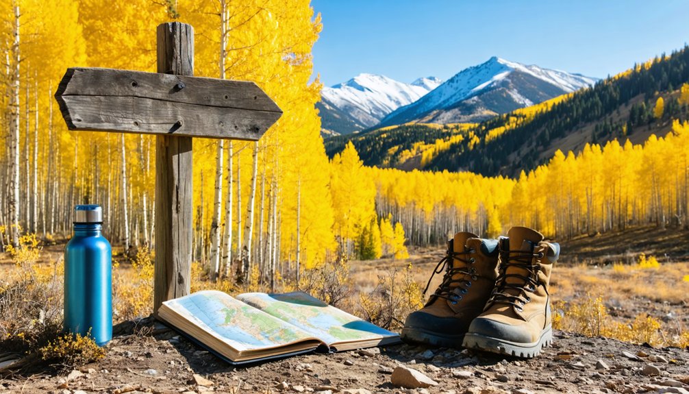
Timing your Boreas adventure can make the difference between traversing passable dirt roads under clear skies and facing muddy ruts in an afternoon thunderstorm. Mid-September through early October delivers explosive fall colors—perfect for autumn photography tips that capture aspen groves ablaze against weathered mining ruins.
Launch morning drives to beat daily lightning triggers above treeline, and pack altitude acclimation recommendations like extra water for the 11,482-foot elevation.
Your vehicle needs high clearance for narrow single-lane stretches, while you’ll want layered clothing and a rain jacket for rapid weather shifts. Bring navigation tools since ghost town pullouts lack markers, plus food provisions—this 22-mile route offers zero services. Midweek visits dodge weekend crowds when you’re chasing unobstructed freedom through Colorado’s mining past.
Where to Stay: The Restored Section House Experience
You can sleep where railroad workers once huddled against mountain storms by booking the restored Boreas Section House, a rare piece of living history perched at 11,482 feet on the Continental Divide. The building nearly collapsed in 1993 before a massive restoration effort transformed it into a fully-equipped backcountry hut that sleeps 12 guests on memory foam mattresses.
During winter months (November through May), you’ll ski or snowshoe in with your gear, fire up the wood stove, and spend the night in what was once the highest narrow gauge railroad station in America.
Historic Section House Rentals
Perched at 11,500 feet on the Continental Divide‘s windswept summit, the Boreas Section House offers one of Colorado’s most unusual overnight experiences—sleeping in a restored 1882 railroad workers’ cabin where winter storms rattle the windows and avalanche terrain begins just beyond your door.
The Summit Huts Association operates this twelve-person cabin as a winter-only rental at just $30 per night through summithuts.org. You’ll cook on propane burners, melt snow for water, and heat the space with a wood-burning stove—just like those railway workers did 140 years ago. The seasonal reservation process runs December through spring, with off season availability non-existent since summer access remains closed. Weekend slots disappear fast, so book early.
Solar lights illuminate your evenings, though gas lanterns provide backup when mountain weather blocks the sun.
Winter Skiing Accommodations
Beyond the historic section house, modern ski cabin rentals dot the hillsides surrounding Boreas Pass, offering creature comforts those 1880s railroad workers could only dream about. You’ll find retro A-frames just 3.5 miles from Peak 9 lifts, complete with hot tubs and fire pits for post-slope relaxation.
Ski cabin amenities have evolved beyond basic shelter—think Tesla charging stations, Starlink WiFi, and modern kitchens stocked with everything you need.
Eco friendly cabin features blend seamlessly with mountain living here. Solar-powered heating warms these elevated retreats while floor-to-ceiling windows frame Ten Mile Range vistas without excess energy waste. Most properties sit steps from free shuttle buses, eliminating vehicle dependency.
Whether you’re crashing in a cozy aspen grove hideaway or a three-story chalet, you’re positioned perfectly for dawn patrol runs and ghost town exploration.
Finding your way to Boreas Pass starts from the heart of Breckenridge, where Main Street becomes CO-9 South. After three miles, you’ll hang a left onto CO-10 East—Boreas Pass Road—and begin your climb through aspen groves toward 11,481 feet. The coordinates 39°24′37″N 105°58′05″W mark the summit on the Continental Divide.
For essential driving tips, remember this 21-mile gravel route follows an old railroad bed with gentle 3% grades—perfectly manageable in a 2WD vehicle during dry conditions. Seasonal access limitations kick in by November 1, when snow closes the pass to automobiles.
Dyersville Ghost Town sits six miles south of Breckenridge at 39°25′14″N 105°59′02″W, accessible via Forest Service Road 593. That final half-mile requires high-clearance 4WD, so plan accordingly.
Frequently Asked Questions
Are Pets Allowed When Visiting the Ghost Towns Along Boreas Pass?
Yes, you’ll find dog-friendly policies along Boreas Pass ghost towns. While there aren’t on-site pet accommodations, you can bring leashed dogs on the scenic drive and trails. Service animals join guided tours exploring abandoned mining settlements.
What Photography Restrictions Exist at the Historic Structures and Burial Sites?
You’ll find no explicit permit requirements for photography at Boreas Pass structures, but visitor etiquette demands you don’t climb displays, damage artifacts, or use drones. Keep groups under five people to maintain your shooting freedom without bureaucratic hassles.
Can Visitors Enter the Old Mine Shafts Near the Ghost Towns?
No, you can’t enter the mine shafts—they’re deliberately filled for mine shaft safety precautions. While exploring abandoned structures like cabins and tramway remnants is possible, sealed shafts and federal regulations prevent underground access near these ghost towns.
Are There Guided Tours Available for the Boreas Pass Ghost Towns?
You’ll find multi-day guided tours for particular ghost towns across Boreas Pass, with groups capped at just four adventurers. Expert guides customize explorations to your interests, though you’ll want to check seasonal hours for ghost town visits beforehand.
The best seasons for Colorado ghost towns are typically spring and fall, when the weather is mild and the scenery is at its most vibrant. During these times, you’ll experience the rich history and haunting beauty of these abandoned places, free from the summer tourist crowds. Be sure to pack accordingly, as temperatures can fluctuate dramatically in the mountains.
As you wander through the abandoned structures in Boreas, Colorado, be prepared to encounter remnants of the past that tell a story of a once-thriving community. Each dilapidated building offers a glimpse into the lives of those who inhabited these mountainous lands, evoking a sense of both nostalgia and intrigue. Capture the eerie stillness of the surroundings, as you immerse yourself in the ghostly atmosphere that surrounds these historical sites.
What Emergency Services Are Available if Problems Occur at This Elevation?
Emergency services are extremely limited at Boreas Pass’s elevation. You’ll find minimal ambulance service availability due to distance and terrain. Medical air evacuation services become your primary rescue option, though weather conditions can delay helicopter response considerably.
References
- http://sites.rootsweb.com/~cosummtp/boreasghost.html
- https://www.4x4explore.com/rds/b_rds/boreas_ps.html
- https://historyplaces.wordpress.com/2015/07/10/history-high-in-the-rockies/
- https://www.youtube.com/watch?v=GXQzNfqakQY
- https://www.uncovercolorado.com/ghost-towns/dyersville/
- https://www.riverridgerentals.com/blog/activites/mysterious-and-spooky-history-summit-county
- https://blog.walkingmountains.org/curious-nature/2016/10/boreas-pass-thats-left-road
- https://www.wedgewoodlodge.com/post/boreas
- https://www.american-rails.com/dssp.html
- https://southparkheritage.org/railroad/


