
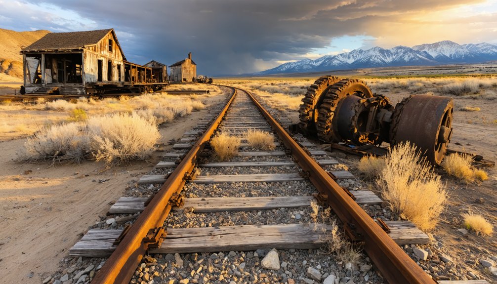
You’ll start your journey twelve miles north of Grand Junction along 27¼ Road, where washboarded dirt climbs through slot canyons toward the Bookcliffs. Pack recovery gear and bring a high-clearance vehicle—spring runoff and summer storms can make passages treacherous. At 5,808 feet, scattered sandstone foundations mark where Carpenter once thrived, while underground coal fires still smolder through hillside cracks, their smoke drifting across a landscape where nature’s reclaimed what miners abandoned, and there’s far more to discover about this haunting site.
Key Takeaways
- Start from Grand Junction and take 27¼ Road north toward the Bookcliffs; high-clearance vehicles recommended for twelve-mile graded dirt trail.
- Visit the Museum of Western Colorado first to view preserved artifacts, mining tools, and Little Book Cliff Railway boxcar.
- Expect scattered sandstone foundations, old railroad grades, and a memorial plaque at the 5,808-foot elevation ghost town site.
- Witness the coal seam fire smoldering since 1923, with smoke vents, steam plumes, and ground reaching 1,000°F temperatures.
- Avoid travel during spring runoff and summer thunderstorms when passages become impassable; dispersed camping available along route.
The Rise and Fall of a Mining Town
In the early 1890s, William Thomas Carpenter had a vision that stretched far beyond the coal seams hidden beneath Mesa County’s rugged terrain. This banker-turned-coal-baron built a mining camp 12 miles northeast of Grand Junction, constructing shacks and family homes that housed fewer than 50 souls.
He didn’t stop there—Carpenter laid 10 miles of narrow-gauge railway, rebranded his settlement as “Poland Springs” to evoke East Coast luxury, and hauled trainloads of well-dressed visitors to his makeshift resort.
The fascinating town history took a sharp turn when the 1893 market crash crushed Carpenter’s ambitions. By 1897, he’d lost everything. The local entrepreneurship challenges proved insurmountable—ownership changed hands twice before Princeton University sealed the mine after a 1924 fire, abandoning the town entirely by 1925.
Getting to the Ghost Town Site
You’ll start your journey north from Grand Junction, following the stretch of 27¼ Road that hugs the desert floor before climbing toward the Bookcliffs. Look for the OHV area near the airport—it’s your gateway to Carpenter Canyon, where the old railroad grade becomes your guide through rust-colored badlands.
The trail itself follows the path miners once took daily, a twelve-mile ribbon of packed earth that any stock vehicle can handle on a clear day.
Directions via 27 1/4 Road
Mesa County Road 27 1/4 serves as your gateway to Carpenter’s remnants, winding through high desert terrain where sagebrush gives way to pinyon-juniper woodland. This backcountry route demands attention—it’s raw Colorado at its finest.
Key navigation points:
- Starting point: Head east from Grand Junction, following the road as it climbs steadily into ghost town territory
- Surface conditions: Expect graded dirt with occasional washboard sections; high-clearance vehicles recommended
- Alternate road route options: Multiple dispersed camping spurs branch off, offering exploration opportunities
- Road condition details: Spring runoff and summer thunderstorms can temporarily render passages impassable
You’ll find excellent OHV access throughout, making this perfect for those who refuse conventional tourist traps. No barriers, no fees—just you and forgotten history waiting along Colorado’s unmarked paths.
Landmarks Near the Airport
Before you even leave Grand Junction Regional Airport, the Bookcliffs dominate your northern horizon—a rust-and-tan fortress where Carpenter’s ruins wait at 5,808 feet. Despite airport facility improvements over the years, this terminal remains modestly small—you’ll grab your pack and hit the road within minutes.
Airport transportation options include rentals perfect for the rough 27 1/4 Road ahead; choose something with clearance. I always stop at the Museum of Western Colorado first to see that weathered Little Book Cliff Railway boxcar, a fragment of the narrow-gauge line that once fed Carpenter’s coal boom. It’s a five-minute detour that grounds the journey in context.
Then you’re northbound, tracing those old railway grades toward smoldering badlands where ghost town silence waits.
Trail Access Points
The old Book Cliff Railroad grade becomes your highway into history, a rust-colored scar carved through sage and shale that’s held its shape for over a century. You’ll find the trailhead where 27¼ Road surrenders to wilderness, twelve miles northeast of Grand Junction at 5,808 feet elevation.
Four access essentials:
- Primary approach follows the historic railway from 1st Street in Grand Junction
- Stock vehicles handle this mild-difficulty route without special modifications
- Unmarked trail turnoffs demand careful navigation through desert badlands
- Pedestrian access difficulties increase near Carpenter Canyon’s mine entrances
The railroad grade that once hauled coal to Grand Junction’s furnaces now guides you past stone foundations and that haunting memorial plaque. Watch for the smoldering earth—that 1923 coal fire still burns underneath your wheels.
What Remains of Carpenter Today
Venture twelve miles northeast of Grand Junction along the extension of 27¼ Road, and you’ll find yourself scanning barren desert badlands for a town that’s nearly vanished. At 5,808 feet elevation, Carpenter’s remnants challenge even determined explorers.
You’ll discover scattered Book Cliff sandstone foundations and fragments of stone embankment—ghostly footprints of structures dismantled by 1925. Visiting town’s plaque memorial honors three teens who died here in 1989 from toxic gases, a sobering reminder of dangers lurking beneath.
Smoke still seeps from the coal seam fire that’s smoldered since 1923, drifting across shifting sands. Old railroad grades trace faint lines through the landscape, while witnessing natural spring obscurity reveals how completely nature reclaims abandoned places. What remains demands your attention to detail.
The Little Book Cliff Railway Legacy
From 1889 to 1925, narrow gauge tracks carved an ambitious twelve-mile path between Grand Junction’s 1st Street and the coal-rich heights of Carpenter, creating what locals knew as the Little Book Cliff Railway. This short line’s historical importance extended beyond industrial necessity—it served as the town’s entertainment lifeline, ferrying wildflower-gatherers on Memorial Day and thrill-seekers aboard the infamous “Go-Devil” gravity car.
More than mere coal transport, this twelve-mile narrow gauge lifeline doubled as Grand Junction’s weekend escape to mountain wildflowers and gravity-powered thrills.
Today, you’ll find scattered remnants marking its environmental impacts:
- Double horseshoe curves visible in the OHV area off 27 1/4 Road
- Little Bookcliff Drive following the original right-of-way
- The preserved Go-Devil at Cross Orchards Historic Site
- A persistent coal seam fire still burning beneath Carpenter since 1923
The railway’s ghost still haunts these desert corridors.
Exploring the Surrounding Desert Badlands
Beyond Carpenter’s crumbling structures, the Book Cliffs badlands stretch across ancient floodplains where gray Chadron claystone and rusty Nasamto caprocks form otherworldly hoodoos and sharp-ribbed gullies. You’ll find OHV trails winding through this eroding landscape—watch for the telltale sulfur smell and heat-cracked earth marking underground coal seams that have smoldered for decades.
The terrain shifts dramatically from flat northern expanses dotted with saltbush to the southern end’s serpentine canyons, where loose clayey soil becomes treacherous slick during rainstorms.
Bookcliffs Base Terrain Features
The desert badlands stretching beneath the Book Cliffs reveal themselves as a masterclass in geological storytelling—layer upon layer of ancient seabed turned to stone, now carved into otherworldly shapes by millions of years of wind and water. You’ll witness eroded escarpment features that expose 5,000 feet of Mancos Shale, each stratum holding fossils of squid, clams, and sharks from when this land rested beneath waves.
Navigate this terrain by recognizing:
- Layered sandstone formations capping soft shale bases—perfect for scrambling
- Steep gorges cutting through badlands parallel to the main escarpment
- Sagebrush and rabbitbrush marking stable paths through unstable terrain
- Wild mustangs roaming rough valleys across 30,000 acres
Your camera won’t do justice to textures found here, but you’ll try anyway.
OHV Trail Adventures
Strap into your OHV and let those geological wonders become your playground. Beyond Carpenter’s ghost town shell, remote desert terrain sprawls with extreme off road routes that’ll test your rig’s limits.
You’ll navigate slot canyons where towering walls close in tight, requiring precise spotting through deep sandy stretches. Sandstone passages demand high clearance and oversized tires as you tackle steep drops into washes carved by ancient floods.
Stock 4WD rigs handle moderate trails, but technical sections need recovery gear and nerve. I’ve watched sunrise paint badlands formations gold from overlooks you can only reach on four wheels.
Watch for rattlesnakes coiled in shade and bighorn sheep scaling impossible cliffs. Pack water—there’s none out here—and prepare for isolation that feels like pure freedom.
Underground Coal Fire Signs
While most ghost towns fade quietly into history, Carpenter’s surrounding badlands tell a more volatile story through centuries-old coal fires that still smolder beneath your boots.
Your thermal vent observations might reveal these telltale signs:
- Smoke wisps rising from hillside cracks, particularly dramatic against winter’s cold air
- Ground temperatures reaching 1,000°F near active vents—hot enough to scorch vegetation
- Steam plumes hissing from fissures where underground fires meet moisture
- Cracked, subsided earth marking where ash voids collapsed beneath the surface
Despite fire suppression techniques involving dirt blankets, gravel fills, and excavation efforts since 1982, these abandoned mine fires prove nearly impossible to extinguish completely. Colorado’s 38 active coal fire sites continue burning for decades, transforming ordinary desert exploration into something remarkably primal.
Where to See Carpenter Artifacts and Learn More
Few places preserve the story of Carpenter better than the Museum of Western Colorado in Grand Junction, where you’ll find artifacts salvaged before vandals picked the site clean in the late 1960s. You’ll discover mining tools, company store ledgers, and photographs documenting the preserved mineral water springs that developers hoped would rival European resorts.
The historical tourism infrastructure—including plans for the Go Devil carnival railway—never materialized beyond sketches and promotional materials now displayed behind glass. Ike Rakiecki’s documentation photos from his desert hikes hang nearby, showing what remained before teenagers discovered the ruins.
The narrow-gauge railway artifacts connect Carpenter’s coal-powered dreams to Grand Junction’s furnaces. It’s your last chance to understand this ghost town before desert winds erase its memory completely.
Frequently Asked Questions
Is It Safe to Visit the Area With the Underground Coal Fire Still Burning?
You can visit, but stay alert to potential health risks from venting fumes and environmental impact near ground holes. Keep your distance from smoke vents, avoid prolonged exposure, and you’ll safely explore Carpenter’s haunting, abandoned streets.
Are There Any Entrance Fees or Permits Required to Access the Site?
No entrance fees or permits are required—you’ll find free access to Carpenter’s ruins. Parking availability is limited along the roadside, and nearby amenities are nonexistent, so pack everything you need for this remote adventure into Colorado’s past.
What Is the Best Time of Year to Visit Carpenter Ghost Town?
You’ll find the autumn months ideal for exploring Carpenter’s weathered structures. With low tourist crowds and crisp mountain air, you’re free to wander undisturbed through history. The golden aspens create stunning backdrops for photography and quiet reflection.
Can You Camp Overnight Near the Carpenter Ghost Town Location?
You’ll find your basecamp paradise at Carpenter Campground’s developed camping facilities, managed by the National Park Service with paid sites. For true freedom seekers, local accommodation options include dispersed spots along nearby forest roads where adventure beckons beyond regulations.
Are Guided Tours Available for the Carpenter Area and Railway Remnants?
You’ll find self-guided tours through Carpenter’s rugged terrain via ADAC’s UTV adventures, letting you explore the railway remnants’ historical significance at your own pace. No formal walking tours exist—just pure freedom across Western Colorado’s dusty badlands.


