To plan your Cedar Creek ghost town road trip, head 54 miles northwest of Tremonton, Utah, via I-15N and Highway 30 near the Utah-Idaho state line. Visit between late spring and early fall for the best conditions. Pack layered clothing, water, offline maps, and a first-aid kit — you’ll need them at 5,161 feet. This forgotten farming settlement tells a raw, unfiltered story of frontier resilience, and there’s far more to uncover ahead.
Key Takeaways
- Cedar Creek Ghost Town is located 54 miles northwest of Tremonton, Utah, accessible via I-15N and Highway 30 near the Utah-Idaho border.
- Visit between late spring and early fall for mild temperatures, wildflower blooms, and optimal road trip and photography conditions.
- Pack layered clothing, sturdy boots, a windbreaker, water, snacks, a first-aid kit, and offline navigation tools for this remote destination.
- Nearby ghost towns like Strevell, Idaho, Snowville, and Park Valley make Cedar Creek an ideal anchor for a multi-site road trip.
- Guided tours offered by local heritage organizations provide expert context and affordable multi-site itineraries connecting Cedar Creek’s agricultural and frontier history.
What Makes Cedar Creek Ghost Town Worth the Drive?
Though it’s easy to overlook Cedar Creek on a map, this forgotten farming settlement in Box Elder County, Utah, rewards curious travelers with a rare, unfiltered glimpse into the struggles of 19th-century frontier life.
Cedar Creek history stretches back to the 1860s, when determined families carved out a farming community near the Utah-Idaho border, only to abandon it by the late 1920s after harsh winters and scarce water defeated their efforts.
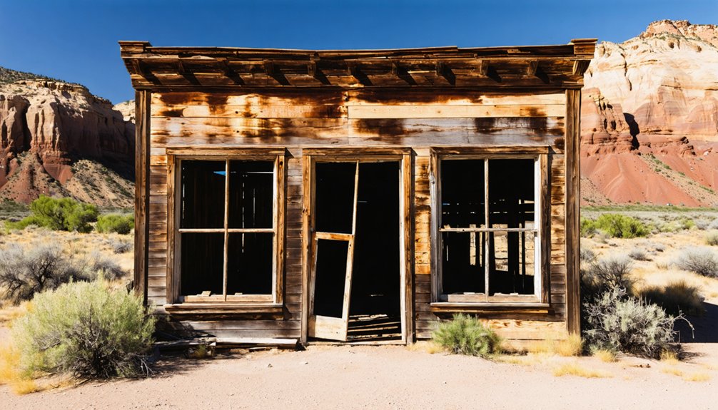
What you’ll find today are weathered remnants that speak louder than any museum exhibit.
Ghost town preservation here isn’t polished or curated — it’s raw, honest, and completely authentic.
There are no glass cases here, no tidy labels — just weathered truth standing exactly where history left it.
You’re standing where real people built real lives and ultimately surrendered them. That unvarnished truth is exactly what makes Cedar Creek worth every mile.
How to Get to Cedar Creek Ghost Town
To reach Cedar Creek Ghost Town, you’ll head northwest from Tremonton on I-15N for approximately 54 miles before picking up Highway 30 near the Utah/Idaho state line.
From there, it’s just 3 miles south of Strevell, making the final approach a quiet stretch of high desert road that sets the mood for what awaits.
Nearby Snowville and Park Valley serve as useful waypoints, each connected by the same interstate corridor that once carried settlers into this rugged corner of Box Elder County.
Starting Point and Route
Reaching Cedar Creek is half the adventure—54 miles northwest of Tremonton, Utah, this forgotten farming settlement sits quietly near the Utah-Idaho state line, just 3 miles south of Strevell along Highway 30.
Jump onto I-15 North and follow it through Snowville, where the landscape opens into stark, windswept terrain that hints at Cedar Creek history’s rugged realities.
From there, Highway 30 carries you directly toward the site, elevation climbing to 5,161 feet as you approach.
The drive itself feels like ghost town exploration before you’ve even arrived—sparse settlements, wide skies, and a palpable sense of distance from modern life.
Keep your tank full and your windbreaker handy; this high-elevation stretch rewards the self-reliant traveler who embraces the open road on their own terms.
Nearby Landmarks and Highways
Once you’re rolling northwest on I-15 and the town of Snowville appears in your rearview mirror, the landscape itself becomes your most reliable landmark—flat, unbroken high desert stretching toward the Utah-Idaho state line.
Highway 30 carries you north toward Strevell, and Cedar Creek sits roughly three miles south of that border crossing. The local geology shifts noticeably here—sage-covered flats giving way to cedar-dotted terrain that inspired the town’s name.
You’ll find wildlife viewing opportunities along these scenic routes, where pronghorn frequently cross open ground. The cultural heritage and historical significance of this corridor run deep, and photography opportunities are genuinely exceptional at golden hour.
Watch for community events hosted by regional heritage organizations—they’ll connect you to nearby attractions that round out your entire ghost town itinerary.
Best Time of Year to Visit Cedar Creek Ghost Town
Timing your visit to Cedar Creek makes all the difference between a rewarding historical expedition and a frustrating ordeal. The best visiting season runs from late spring through early fall, when ideal weather conditions let you explore freely at this 5,161-foot elevation.
Pack accordingly and plan smart:
- Late Spring (May-June): Wildflowers frame abandoned structures, temperatures stay mild, and daylight hours maximize exploration time.
- Summer (July-August): Peak conditions for photography and multi-site road trips connecting nearby ghost towns.
- Early Fall (September-October): Cooler air, stunning light, and thinner crowds reward independent travelers seeking authentic discovery.
Winter visits aren’t recommended—the same harsh weather that ultimately drove settlers away still dominates this remote northwestern Utah landscape.
What to Pack for a Cedar Creek Ghost Town Visit
When you step into Cedar Creek’s wind-swept remnants at 5,161 feet, you’ll want layered clothing, sturdy boots, and a windbreaker to combat the elevation’s unpredictable chill.
Pack a compass, topographic map, or GPS device, since reliable cell service can’t be counted on in this remote corner of Box Elder County.
A charged power bank, first-aid kit, and extra water will round out your gear, keeping you self-sufficient as you walk the same ground those 20 to 30 farming families once called home.
Essential Clothing And Gear
Exploring Cedar Creek’s windswept ruins at 5,161 feet means you’ll want to dress and pack smart before heading out. The elevation brings cooler temperatures and unpredictable gusts, so these clothing essentials and gear recommendations will keep you comfortable and focused on discovery:
- Windbreaker or layered jacket — Cedar Creek’s exposed terrain channels strong winds, making a packable windbreaker your most valuable clothing essential.
- Sturdy, closed-toe hiking boots — Crumbling foundations and uneven ground demand solid ankle support and reliable grip.
- Daypack with water and snacks — Remote access means no nearby services, so carry your own supplies.
With the right gear, you’ll move freely through Cedar Creek’s abandoned structures, connecting authentically with the farming families who once weathered these same relentless conditions.
Three essential navigational tools will keep you oriented across Cedar Creek’s remote, unmarked terrain: a downloaded offline map of Box Elder County, a reliable GPS device, and a traditional paper map as a backup.
Technology fails in isolated high-desert corridors, so don’t rely solely on navigational apps when you’re 54 miles northwest of Tremonton on I-15N.
Add local maps and GPS devices to your travel checklists before departure.
Route planning should account for Highway 30‘s approach near Strevell, where signage becomes sparse. Download offline navigational apps while you’re still in Tremonton or Snowville, where connectivity exists.
Cedar Creek’s elevation of 5,161 feet and surrounding backcountry demand road trip essentials that work without cell towers.
Come prepared, and the ghost town’s forgotten roads will reveal themselves.
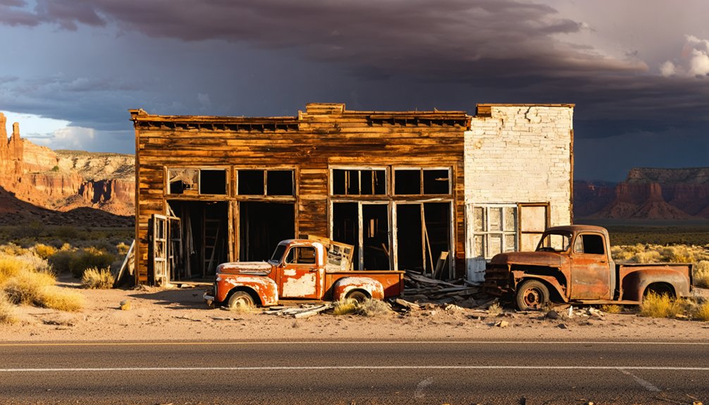
What’s Left Standing in Cedar Creek Today?
Though time and harsh winters have claimed much of Cedar Creek, a few structures still stand as silent witnesses to the farming families who once called this remote corner of Box Elder County home.
These remaining structures carry deep historical significance, connecting you directly to the 1860s settlers who carved life from this unforgiving landscape.
When you walk the site, watch for:
- Abandoned residential buildings — skeletal frames revealing how 20-30 families once weathered brutal Utah winters
- The original general store remnants — where John Jenson supplied an entire isolated community
- Deteriorating outbuildings — quiet evidence of agricultural ambitions that ultimately surrendered to insufficient water and relentless weather
Each crumbling wall tells a story worth discovering on your own terms.
The Farming Community That Couldn’t Survive
Cedar Creek’s story is one of stubborn hope colliding with an indifferent landscape. Settlers arrived during the 1860s-1870s, carving out a farming community at 5,161 feet elevation near the Utah-Idaho border.
At peak population, 20 to 30 families demonstrated remarkable community resilience, building schools, stores, and homes against considerable odds.
At its height, Cedar Creek’s 20 to 30 families built schools, stores, and homes against remarkable odds.
But the land fought back. Farming challenges mounted relentlessly — brutal winters, scarce water, and unforgiving terrain slowly strangled agricultural productivity.
You can almost feel the quiet desperation as families packed their belongings one by one throughout the late 1920s, leaving behind everything they’d built.
Ghost Towns Near Cedar Creek Worth Adding to Your Route
Once you’ve walked Cedar Creek’s silent streets, you won’t want the journey to end — and fortunately, Box Elder County rewards the curious traveler with several ghost towns clustered near the Utah-Idaho border.
Each site carries its own abandoned structures and distinct historical significance, deepening your understanding of frontier resilience.
Consider adding these stops to your route:
- Strevell, Idaho — Just 3 miles north, this border settlement offers hauntingly preserved remnants worth exploring.
- Snowville, Utah — A nearby community where history lingers along Highway 30’s windswept corridor.
- Park Valley, Utah — An isolated valley settlement revealing agricultural struggles mirroring Cedar Creek’s own story.
Travel Highway 30 freely, connect these sites, and let the landscape tell its unfiltered story.
How to Build a Box Elder County Ghost Town Road Trip Around Cedar Creek
Building a Box Elder County ghost town road trip around Cedar Creek gives you a natural anchor point — a historically-grounded site that’s accessible via I-15N, positioned roughly 54 miles northwest of Tremonton, and sitting just 3 miles south of the Utah-Idaho border on Highway 30.
From here, you can fan outward, connecting nearby abandoned settlements into a single, purposeful route. Cedar Creek’s ghost town history — rooted in 1860s farming ambitions that ultimately collapsed under harsh winters and scarce water — sets the tone for understanding why so many communities across this high desert landscape share similar fates.
Use Snowville and Park Valley as practical waypoints. You’re not just driving between ruins; you’re tracing the fragile arc of human settlement across northern Utah’s unforgiving terrain.
Can You Join an Organized Cedar Creek Ghost Town Tour?
Whether you prefer the structure of a guided experience or the freedom of solo exploration, organized tours do exist for Cedar Creek and the broader Box Elder County ghost town circuit.
Local heritage organizations arrange Cedar Creek tours and organized events that connect you directly to the region’s agricultural past.
Here’s what these experiences typically offer:
- Expert-led context — Guides interpret the abandoned structures, explaining why harsh winters and water scarcity emptied this once-thriving farming community.
- Multi-site itineraries — Organized events often bundle Cedar Creek with nearby ghost towns, maximizing your road trip efficiently.
- Low-cost access — Most tours remain free or affordable, keeping your exploration budget intact.
Check local Box Elder County historical societies for current scheduling before you head out.
Frequently Asked Questions
Is Cedar Creek Ghost Town Located on Private or Public Land?
The knowledge doesn’t specify whether Cedar Creek’s land is private or public. Before you chase Cedar Creek history and ghost town legends, you’ll want to verify land ownership status with Box Elder County authorities to guarantee lawful access.
Are There Any Restroom Facilities Available at Cedar Creek Ghost Town?
Don’t expect restroom accessibility or visitor amenities at Cedar Creek’s weathered ruins — this untamed ghost town offers raw, unfiltered freedom. Plan accordingly, pack your own supplies, and embrace the rugged, pioneering spirit that once defined this historic settlement.
Can Visitors Take Photographs or Video Inside Cedar Creek’s Remaining Structures?
No specific photography guidelines exist for Cedar Creek, so you’re free to capture its historical significance! Document these weathered remnants, letting your lens honor the resilient farming families who once called this evocative, abandoned Utah frontier community home.
Is Cedar Creek Ghost Town Suitable for Young Children to Visit?
“Curiosity killed the cat!” Cedar Creek’s crumbling structures demand careful safety precautions with young children. You’ll find limited child-friendly activities here, but exploring this historically-rich ghost town together sparks priceless wonder and freedom you won’t forget.
Are Pets Allowed When Visiting Cedar Creek Ghost Town?
The knowledge doesn’t specify pet policies for Cedar Creek. However, if you’re bringing a furry companion, practice good ghost town etiquette — keep them leashed, respect the historic remnants, and let freedom ring responsibly.
References
- https://en.wikipedia.org/wiki/Cedar_Creek
- https://kids.kiddle.co/Cedar_Creek
- https://www.houseofhighways.com/usa/west/utah/cedar-creek
- https://www.discoverheritagehub.com/articles/cedar-creek-ut/
- https://en.wikipedia.org/wiki/List_of_ghost_towns_in_Utah
- https://www.youtube.com/watch?v=eLGiwso6oZI
- https://www.visitutah.com/things-to-do/history-culture/ghost-towns
- https://vp-mi.com/news/2024/aug/21/history-tour-explores-cedar-creek-ghost-town/
- https://en.wikipedia.org/wiki/Mohrland
- https://ecprogress.etvnews.com/index.php/2017/06/30/tour-of-mohrland-ghost-town-mining-town/


