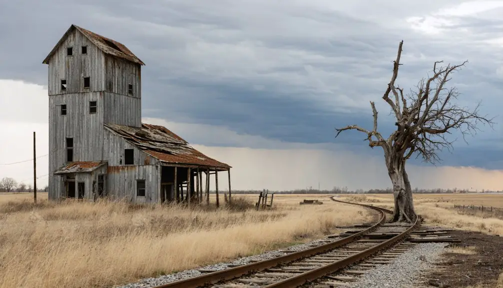
You’ll find Dale along U.S. Highway 10 between Fargo and Moorhead, though you’ll need GPS coordinates (46°54’17″N 96°13’12″W) since signage is nonexistent. The ghost town features a standing grain elevator and general store beside active BNSF tracks where Amtrak’s Empire Builder still passes through. Visit during summer months for favorable road conditions, and bring offline maps as cell service is unreliable. Pack sturdy footwear, water, and camera gear for this remote location. Planning ahead guarantees you’ll maximize your exploration of this forgotten railroad settlement.
Key Takeaways
- Access Dale via U.S. Highway 10 from Fargo or Moorhead, then follow county roads toward Hitterdal using GPS coordinates 46°54’17″N 96°13’12″W.
- Download offline maps before departure since cell service is unreliable and signage is nonexistent in the area.
- Visit between spring and fall for optimal road conditions; winter snow frequently blocks unmarked township routes.
- Bring sturdy footwear, water, and camera gear to explore the grain elevator, general store, and decaying foundations.
- Park cautiously at roadside gravel pull-offs and watch for active railroad tracks including Amtrak’s Empire Builder route.
Reaching Dale requires careful planning, as this Clay County ghost town sits tucked away in section 34 of Highland Grove Township, roughly 25 miles east of the Fargo-Moorhead area. You’ll navigate primarily via U.S. Highway 10 from either Fargo or Moorhead, then shift to county roads leading north toward Hitterdal.
GPS coordinates 46°54’17″N 96°13’12″W pinpoint the exact location, essential since signage is nonexistent. Download offline maps beforehand—cell service proves unreliable here.
Spring through fall offers ideal road conditions; winter snow often blocks unmarked township routes. Parking options are limited to roadside pull-offs along gravel stretches. Watch for potential hazards including soft shoulders, agricultural equipment, and private property boundaries.
The site’s remoteness means zero services nearby, so fuel up beforehand and bring supplies.
What Remains: Exploring the Ghost Town Landscape
When you arrive in Dale, you’ll find the grain elevator and general store still standing as silent sentinels of the past.
The active railroad tracks cut through the landscape, with Amtrak’s Empire Builder and other trains regularly rumbling past these weathered remnants.
Surrounding farmland stretches beyond the sparse structures, creating a stark contrast between the working agricultural present and the abandoned village’s quiet history.
Historic Building Foundations Today
Although Dale’s bustling streets and storefronts have vanished, subtle traces of the town’s architectural past still mark the landscape. You’ll discover decaying foundations scattered across the site—remnants of the town hall, jail, grain elevator, and private homes that once formed this community’s backbone.
Stone and brick materials from original structures remain identifiable, with building outlines still visible through foundation impressions. The thick brick walls occasionally persist, though weather and neglect have compromised their integrity over decades.
Soil composition impacts how well these remnants survive. Moisture levels and seasonal cycles accelerate deterioration of exposed materials, while vegetation both obscures and stabilizes remaining foundations. You’re free to explore these tangible connections to Dale’s past, traversing paths that reveal early 20th-century construction methods frozen in time.
Railroad Tracks Still Active
Unlike the crumbling foundations scattered across Dale’s former townsite, the railroad tracks that once breathed economic life into this community continue their purpose today. You’ll discover these steel ribbons still serving western Minnesota’s agricultural shippers, defying the ghost town’s fate. Route ownership changes have shifted control between major carriers over decades, yet freight operations persist.
Current activity along these historic corridors includes:
- Single daily trains supporting freight shippers in nearby communities
- Major carriers implementing capacity expansion plans with double-track projects
- Investment in relaying main track sections between active shipping points
- Short lines leasing trackage to maintain agricultural commerce connections
Minnesota’s Rail Viewer application lets you track these active routes, revealing how Dale’s transportation lifeline survived while the town itself faded into memory.
Rural Farmland Surroundings
This wide-open landscape offers unobstructed views and profound isolation, letting you experience the dramatic transformation from community hub to agricultural frontier.
Historical Landmarks and Points of Interest
When you arrive at Historic Forestville, you’ll step into a remarkably preserved slice of 1850s frontier life along the Root River in southeastern Minnesota. The Minnesota Historical Society maintains this authentic settlement where you’ll discover:
- The Meighen General Store – Still stocked with 1890s merchandise exactly as customers would’ve found it
- Original Family Homestead – The Meighen house and barn showcase frontier architecture
- Forestville Bridge – A stunning example of 19th-century engineering spanning the Root River
- Mystery Cave – Minnesota’s longest cave system with spectacular underground formations
Town demise reasons become clear when you learn the railroad bypassed Forestville, strangling commerce and triggering population collapse from a thriving community to just 55 residents.
Agricultural development impacts shifted as the Meighen family eventually owned everything, operating until 1910 before abandonment.
Best Times to Visit and What to Bring

Planning your Dale ghost town adventure requires strategic timing since the remote Clay County location experiences dramatic seasonal shifts that’ll noticeably impact your exploration experience. Understanding temporal visitation patterns helps you maximize comfort—summer months (June-August) deliver warm conditions perfect for extended wandering between the grain elevator and general store ruins.
Winter demands respect, with December-February snow requiring heavy layers and insulated boots. Spring and fall transitions offer ideal mild weather with minimal crowds.
Appropriate packing strategies center on essentials: sturdy footwear for traversing deteriorating structures, water for the isolated location between Hawley and Lake Park, and camera gear to capture architectural details. Sun protection matters during warmer months, while winter visitors need comprehensive cold-weather apparel. Your two-wheel-drive vehicle handles the route fine—just bring navigation tools for precise positioning.
Nearby Amenities and Lodging Options
Dale’s isolated Clay County location means you’ll need to venture beyond the ghost town itself for creature comforts—the nearest substantial amenities cluster around Hawley (approximately 12 miles southeast) and Lake Park (roughly 10 miles northwest).
For overnight stays, consider these distinctive Minnesota options:
- Dale’s on Lake of the Woods Lodging provides pet friendly accommodations with sleeper fish house rentals featuring drop-down beds that stay warm even during -30°F windchills
- Palmer House Hotel in Sauk Centre delivers authentic haunted hotel ambiance—built in 1901, it’s notorious for Room 17’s ghostly encounters and unexplained phenomena
- Water Street Inn along Stillwater’s St. Croix River combines 1890s architecture with reports of phantom footsteps and self-operating doors
- Regional camping options near Lanesboro include Amish-built cabins with full amenities and vacation rentals sleeping groups up to 25
Photography Opportunities Along the BNSF Tracks
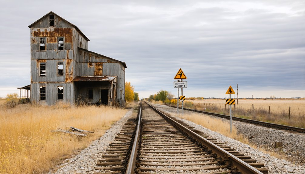
You’ll find excellent vantage points along the BNSF tracks near Dale to photograph Amtrak’s Empire Builder as it speeds through Minnesota’s rural landscape. The area’s historic railroad infrastructure—including weathered trestles and vintage signals—provides compelling foregrounds against the ghost town’s backdrop.
Position yourself safely off railroad property during golden hour to capture dramatic lighting on passing locomotives framed by Dale’s abandoned buildings and surrounding farmland.
Capturing Passing Empire Builder
Where can you position yourself for that perfect shot of the Empire Builder slicing through Minnesota’s rural landscape? Chasing the train becomes an adventure when you know the ideal spotting locations along BNSF’s mainline near Dale.
Prime photography positions include:
- Staples Amtrak Station offers unobstructed trackside views as the daily eastbound service passes through afternoon hours
- Rural stretches between St. Cloud and Staples provide open farmland backdrops with ghost town authenticity
- Summer’s extended daylight maximizes your shooting window, while winter delivers dramatic snow-covered contrasts
- Roadside pullouts along BNSF corridors near Detroit Lakes capture freight-mixed operations
The Empire Builder’s predictable daily schedule—running approximately 46 hours from Seattle to Chicago—positions Minnesota passages during suitable afternoon-evening light. Real-time tracking apps help you anticipate arrivals within 3-5 minute windows, ensuring you’re ready when 2,200 miles of journey thunders past your viewfinder.
Historic Railroad Infrastructure Shots
The railroad infrastructure threading through Minnesota’s landscape tells stories spanning 160 years, offering photographers dramatic compositions where engineering meets abandonment. You’ll find compelling shots at Northtown Yard’s hump yard classification tracks, where 105 miles of rails spread across 250 acres between Minneapolis and Fridley. The elevated 21.5-foot hump provides unique vantage points, especially when capturing snow melter equipped switches during winter operations.
Historic depot remnants near Brainerd sit hauntingly between Hubert and Upper Fishtrap lakes, their 1911 construction now weathered and photogenic. Along the Mississippi River corridor from Savanna to St. Paul, exposed trackage reveals where Northern Pacific extended lines in 1886. Robbinsdale’s Great Northern crossing at Rockford Road showcases platform remnants and modified station roofs from the 1950s—perfect for documenting rail heritage’s decay.
Combining Your Visit With Detroit Lakes Area Attractions
While Dale itself offers a fascinating glimpse into Minnesota’s vanished settlements, the nearby Detroit Lakes area transforms your ghost town visit into a full-fledged adventure. You’ll discover over 400 lakes within 25 miles, perfect for exploring by kayak or pontoon rental from J and K Marine.
Essential Detroit Lakes Experiences:
- Hunt for six giant Thomas Dambo troll sculptures scattered throughout the region, starting at City Park with clues leading to a golden rabbit
- Explore 43,000-acre Tamarac National Wildlife Refuge, home to wolves, bears, and 250+ bird species
- Browse Shady Hollow Flea Market’s 100+ vendors for vintage treasures on summer weekends
- Sample local cuisine offerings at restaurants near the historic Holmes Theatre
Seasonal tourism considerations matter here—visit during Polar Fest for winter adventures or Festival of Birds for spring migrations.
Frequently Asked Questions
Is It Legal to Explore Dale’s Abandoned Structures and Private Property?
No, you can’t legally explore Dale’s structures without permission. You’ll need to obtain necessary permissions from property owners and respect private property rights. Trespassing risks criminal charges and fines, even in seemingly abandoned ghost towns.
What Caused Dale’s Population to Completely Disappear as a Town?
Dale’s population vanished when diesel trains stopped making water stops, triggering economic decline. You’ll find that dwindling opportunities forced residents elsewhere—businesses closed, the post office shuttered in 1971, and the community simply faded away.
Are There Any Local Legends or Ghost Stories Associated With Dale?
Dale doesn’t have widely documented haunting folklore or eerie occurrences like Minnesota’s other legendary sites. However, abandoned towns often inspire local whispers and unexplained experiences. You’re free to explore and create your own ghostly discoveries in this forgotten settlement.
Can You Still See Foundation Remains of Andrew Jelsing’s Original Saloon?
No visible foundation remains of Andrew Jelsing’s saloon exist today. Despite the historical significance of Jelsing’s establishment as Dale’s village core, buildings have vanished. Saloon foundation visibility is zero—the site’s completely cleared, leaving only railroad tracks cutting through empty prairie.
Do BNSF Railway or Amtrak Allow Pedestrian Access Near the Tracks?
No, pedestrian access isn’t allowed near active BNSF tracks except at designated crossings. You’ll need to avoid trespassing on active rail lines and seek landowner permission to explore private property when visiting Dale’s remnants.