You’ll find Donnan’s ghost town site at coordinates 42°53’46″N 91°52’41″W in central Fayette County, approximately 7 miles southwest of West Union at the intersection of New Donnan Road and Woodard Street. This former railroad junction, Iowa’s smallest incorporated city before its 1991 disincorporation, now features only commemorative markers where two major railroads once crossed. The Fayette County Museum in West Union maintains a dedicated Donnan room with artifacts documenting the settlement’s 1878-1991 existence, and the guide below reveals essential visiting strategies and historical context.
Key Takeaways
- Donnan is located 7 miles southwest of West Union at the intersection of New Donnan Road and Woodard Street in Fayette County.
- The site features a commemorative monument and plaque marking where two major railroad lines once crossed this agricultural hub.
- Minimal physical structures remain; the depot, grain elevator, and businesses vanished after the town disincorporated with just 7 residents.
- Visit the Fayette County Museum in West Union to see the dedicated Donnan room with artifacts from 1878-1991.
- The ghost town is approximately 2 miles north of Randalia, making it easy to visit multiple historical sites.
The Rise and Fall of Iowa’s Smallest Incorporated City
On July 10, 1874, federal authorities established a post office in what would become Donnan, Iowa, marking the settlement’s first official recognition.
You’ll discover a community that embodied small town resilience through its 1922 incorporation, when residents built infrastructure including schools, shops, and a railroad depot serving fifty residents across one square mile. The settlement was named after pioneer lawyer and Civil War officer William Donnan. By the time of disincorporation, the population had dwindled to just 7 residents, making it Iowa’s smallest town.
Understanding Donnan’s Strategic Railroad Junction Location
You’ll find Donnan’s location made perfect geographic sense in 1878—positioned where the Chicago, Milwaukee, St. Paul and Pacific Railroad intersected the Chicago, Rock Island and Pacific Railroad, southwest of West Union. The junction sat along an open prairie route between Independence and West Union, with stations at Long Grove (Maynard), Hazelton, Oelwein, and Randalia establishing a vital agricultural corridor.
What’s remarkable is how planners envisioned extending the Volga Branch westward from Lima through Spring Valley, requiring rock cuts near Fayette village and two miles west under Highway 93, though they ultimately abandoned this route for a spur to West Union instead. The settlement’s name appears on various related articles that help distinguish between different places and features sharing similar designations in Iowa’s railroad history. The region’s extremely fertile prairie soil, created by ancient glacial action, made these agricultural corridors economically viable for the expanding railroad networks.
Two Major Railroad Lines
When surveyor’s stakes marked Donnan Junction in 1878, the community’s founding hinged entirely on the convergence of two major rail lines: the Chicago, Milwaukee, St. Paul and Pacific Railroad intersecting with the Chicago, Rock Island and Pacific Railroad. You’ll find these diagonal tracks carved through the town layout, splitting blocks 1, 4, and 5 in ways that defied conventional grid patterns.
The Milwaukee Road and Rock Island partnership created the infrastructure for depot operations and grain elevator services that defined the settlement’s purpose. Farmhouses fronted these intersecting rails, their residents betting everything on sustained traffic through this crossroads.
Regional Agricultural Hub Role
The railroad convergence that brought Donnan into existence demanded immediate agricultural infrastructure to justify its location. You’ll find documentation of a grain elevator, stock yards, implement company, and hardware store—all clustered where Rock Island and Great Western tracks met. This wasn’t coincidental.
Northeast Iowa’s corn-livestock economy required assembly points where farmers could ship hogs and cattle while securing machinery for their operations. Regional tile drainage projects transformed wet prairie into productive cropland after 1904, with cooperative districts installing larger drainage systems that enhanced grain yield impacts across Fayette County. Tile kilns and factories popped up across the state to meet the growing demand for drainage tiles as farmers recognized underground drainage technology was essential for making Iowa’s swamps and sloughs farmable. The implement company likely stocked steel plows and reapers that solved earlier problems of prairie soil sticking to wooden equipment, enabling farmers to break the tough sod more efficiently.
The town’s population peaked at fifty during the 1940s, when these facilities processed maximum throughput. By 1977, the abandoned elevator stood as evidence of Donnan’s former role channeling agricultural output toward national markets.
How to Find the Former Townsite in Fayette County
You’ll find Donnan‘s former townsite at coordinates 42°53′46″N 91°52′41″W in central Fayette County, approximately two miles north of Randalia along the former Rock Island railroad corridor.
The platted area encompassed five blocks bounded by Maple, Logan, and Sumner streets running north-south, intersected by Woodard Street and Washburn Avenue.
New Donnan Road now marks the site with a monument, while the Fayette County Museum in West Union maintains a dedicated Donnan room documenting the settlement’s 1878-1991 existence. A Donnan Junction Sign marks the location of this former railroad community. The town incorporated in the 1920s so that a school could be built, serving the needs of the small community before its eventual decline.
Exact Location and Coordinates
Locating Donnan’s former townsite requires traversing to the intersection where New Donnan Road meets Woodard Street in southwestern Fayette County, approximately seven miles southwest of West Union’s city center.
While exact coordinates aren’t formally published, the intersection layout positions you at the historical junction where two major railroads once crossed. Woodard Street’s convergence with Maple Street marks another remnant corridor.
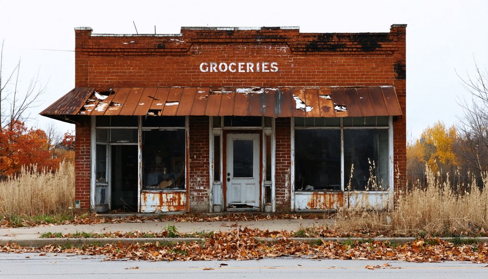
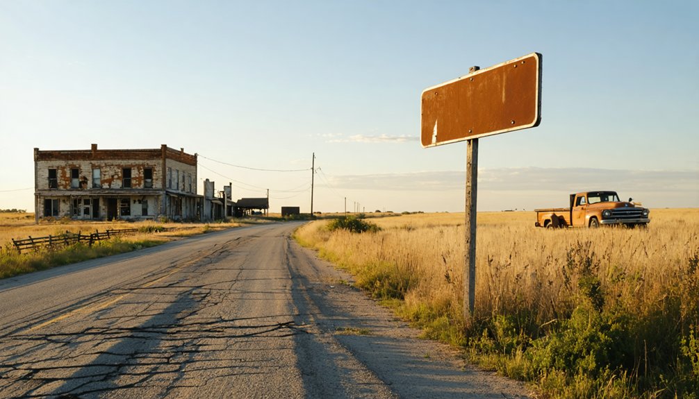
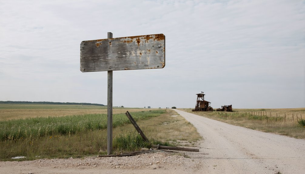
You’ll find minimal physical evidence—just a commemorative sign and plaque documenting the settlement’s 1874 founding and 1991 dissolution. The railroad depot that once anchored this community has vanished, along with the grain elevator and supporting businesses. Donnan represents one of over 3,800 ghost towns that have been researched across the country, contributing to Iowa’s own collection of abandoned settlements. Like other vanished municipalities such as Fort Madison and Iowa City that have transformed over time, Donnan shares the fate of Iowa’s changing landscape.
Navigate via county roads to reach this unobstructed site, where historical markers stand as sole witnesses to Iowa’s smallest incorporated city.
Nearby Landmarks and Directions
Finding Donnan requires using West Union as your primary navigation reference point, positioned seven miles northeast of the ghost town site. Navigate to the intersection of New Donnan Road and Woodard Street, where you’ll discover the town’s primary remnants.
The town layout followed a simple grid with Maple, Logan, and Sumner streets running north-south through the former community. A memorial sign and plaque mark the exact townsite location, while a roadside monument on New Donnan Road pays tribute to this vanished railroad junction.
Two miles south, you’ll find Randalia, Donnan’s nearly empty sister community that lost its post office in 2007. The Fayette County Museum in West Union maintains a dedicated Donnan room displaying artifacts from the farming operations that once sustained this small settlement.
What You’ll Actually See at the Donnan Site Today
At the intersection of New Donnan Road and Woodard Street (42°53′46″N 91°52′41″W), a solitary monument marks what remains of this extinguished community southwest of West Union. You’ll find a roadside sign and commemorative plaque documenting Donnan’s disincorporation—tangible proof of governmental erasure.
The landscape reveals scattered collapsing structures across overgrown farmland, with foundations and pottery shards accessible to persistent explorers. The eerie atmosphere intensifies as you trace the walkable old railroad right-of-way where two major lines once intersected.
Local lore and legends preserve stories the physical site can’t tell. For deeper context, visit the dedicated Donnan room at Fayette County Museum in West Union, where plat maps and artifacts archive this vanished rail junction’s complete history before rural depopulation claimed another Corn Belt casualty.
The Historic 1991 Disincorporation Vote That Made Headlines

You’ll find no dramatic political debates in this story—just seven exhausted residents choosing freedom from bureaucratic burden. Six voted for disincorporation; only Elwood Gage opposed. His wife Margaret sided with the majority, though no marital dispute followed.
Resident perspectives were unanimous about administrative fatigue: they’d grown tired of rotating City Council positions and managing municipal paperwork.
The decision transferred street maintenance to Fayette County and left the state to settle final bills. Iowa’s smallest town simply walked away from itself, effective 1991.
Best Time of Year to Visit This Northeastern Iowa Ghost Town
While Donnan’s remnants remain accessible year-round, autumn emerges as the decisive season for ghost town exploration in northeastern Iowa. Summer’s dense vegetation obscures abandoned structures, but fall’s die-back reveals hidden foundations and forgotten artifacts. You’ll find optimal visibility during off season conditions, when cleared sightlines document what summer foliage conceals.
September through October delivers ideal fall foliage viewing alongside practical exploration benefits—temperatures ranging between comfortable highs and crisp evenings eliminate winter’s harsh 17°F conditions and summer’s oppressive heat. The frost-free period’s conclusion transforms overgrown sites into archaeological landscapes. Indian Summer’s mild, dry Pacific air masses create stable documentation weather, while autumn’s reduced precipitation (compared to summer’s convective thunderstorms) guarantees accessible terrain.
Eastern Iowa’s 37-inch annual precipitation concentrates summer months, making fall’s drier conditions strategically advantageous for unrestricted ghost town investigation.
Nearby Attractions and Towns to Include in Your Trip

You’ll find West Union serving as your practical base camp, positioned southwest of Donnan at the New Donnan Road and Woodard Street junction. The county seat houses Fayette County’s courthouse and historical society, where museum collections document the region’s vanished settlements through photographs, land records, and artifacts from Donnan Junction’s railroad era.
This infrastructure allows you to anchor a systematic exploration of northeastern Iowa’s ghost town circuit, connecting preserved remnants with archival evidence at the historical society.
West Union Historic Sites
West Union, the Fayette County seat located approximately 12 miles northeast of Donnan, anchors your regional exploration with five distinct historic and recreational sites. The town’s preserved West Union architecture centers on the 1903 Fayette County Historical Center at 100 N Walnut St, where three levels document military, agricultural, and genealogical records.
West Union recreation venues extend beyond the 40-acre Recreation Complex to Echo Valley State Park‘s CCC-era structures and 100 acres of trails.
- Fayette County Historical Center: Three-story brick building housing surname files, census records, and local military exhibits (free admission, Mon-Fri 10am-3pm)
- Echo Valley State Park: 100 acres featuring CCC dam remains, keystone archway, lime kiln, and primitive camping
- Greene Streetscape Pilot Project: Award-winning permeable pavers and rain gardens demonstration
- Historic Courthouse Square: Preserved downtown district with period storefronts
- Recreation Complex: 40-acre facility with fishing ponds and wildflower gardens
Fayette County Museum Collections
Since its 1979 opening in a restored 1867 Presbyterian Church, the Fayette County Historical Center at 100 N Walnut St has catalogued approximately 9,000 donated artifacts across three accessible levels. You’ll discover artifact preservation techniques applied to cornhusk dolls by Joyce Grimes (featured in Midwest Living 1990), the ‘Tupper’ Red Cross quilt commemorating Lloyd Tupper’s 1918 death, and political memorabilia spanning county history.
Collection management challenges include maintaining temperature-controlled environments for textile artifacts like military jackets and agricultural exhibits featuring the Holstein cow from Humphry Dairy Restaurant. The museum operates Monday-Friday 10 a.m.-3 p.m., offering free admission with research rooms available by appointment. Historical Vandalia Inc.’s documentation emphasizes Vandalia’s 1819-1839 capital years and Abraham Lincoln’s 1830s presence, ensuring you’ll access authentic historical records independently.
Regional Ghost Town Routes
Beyond Donnan’s remaining sign and plaque at New Donnan Road’s intersection with Woodard Street, Fayette County’s ghost town network extends through three distinct regional routes spanning 50 to 126 miles from your starting point.
- Bryantsburg Circuit (126 miles northwest): This unincorporated settlement preserves abandoned buildings from its 1920s banking era, now surrounded by Amish farmsteads offering regional connections to agricultural heritage.
- Conover Loop via Highway 150: Journey northward to Winneshiek County’s 32-saloon town, abandoned after 1860s railroad relocation to Calmar, featuring eerie structural remnants.
- Buckhorn Route (Highway 20/64 southwest): Jackson County’s most intact site includes abandoned church and creamery with occasional owner-guided property tours.
- Iowaville Extension (95 miles): Archaeological site documenting Ioway and Sauk Indian history near Des Moines River.
- Suggested 50-mile circuit: Donnan-Bryantsburg-Conover county road loop.
Capturing the Perfect Photos at Donnan’s Memorial Markers
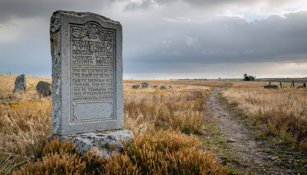
Standing at the intersection of New Donnan Road and Woodard Street, you’ll find Iowa’s most poignant roadside memorial—a modest sign and plaque marking what was once America’s smallest incorporated city. Your camera lens should capture the visual cues of abandonment: empty building foundations, ghost streets named Maple and Logan, and farmland reclaiming five former city blocks.
Golden hour lighting transforms this memorial into powerful documentation. Position yourself low to emphasize isolation against the flat Iowan Surface terrain. Wide-angle shots reveal the railroad junction where two lines once intersected, driving Donnan’s brief prosperity. Overcast conditions provide evocative framing without harsh shadows.
Complement your shoot by documenting the nearby Stone Man glacial erratic—another monument to forces that shaped and ultimately erased this landscape.
Local Museums and Historical Resources to Enhance Your Visit
Before departing Donnan’s windswept memorial site, plan your stop at the Fayette County Historical Center Museum in West Union, fifteen miles northeast. This repository preserves the tangible record of communities that chose independence, then vanished. The dedicated Donnan Room houses museum exhibits documenting your destination’s complete arc—from 1874 railroad junction to ghost town monument.
These archives hold the complete story of settlements that claimed autonomy before disappearing into Iowa’s prairie landscape.
Operating Monday through Friday, 10 a.m. to 3 p.m., the facility maintains community archives including:
- Diorama of John Walker General Store showing commercial operations
- Town plat revealing five blocks bisected by diagonal railroad tracks
- Military Room displaying historical uniforms and equipment
- Library containing yearbooks, telephone directories, and school records
- Lima Village display featuring early postal boxes and church architecture
Schedule appointments for unrestricted access to primary sources documenting Fayette County’s vanished settlements.
Essential Road Trip Tips for Exploring Rural Iowa Ghost Towns
When approaching Donnan’s memorial site at the intersection of New Donnan Road and Woodard Street, you’ll navigate rural Fayette County terrain that demands logistical preparation urban visitors often overlook. Transportation challenges include limited fuel stations and services—stock essentials in West Union before departure. Your vehicle requires proper maintenance for unpaved rural roads where emergency response times extend considerably.
Seasonal accessibility concerns intensify during Iowa winters when snow and ice compromise road conditions. Plan visits between May and October for ideal navigation and photography opportunities. Respect all private property boundaries surrounding the memorial markers; trespassing restrictions apply throughout the area.
Document your journey systematically: photograph commemorative plaques, surrounding landscape, and remaining structural evidence from appropriate public vantage points. This methodical approach captures Donnan’s historical significance while maintaining legal compliance.
Frequently Asked Questions
Are There Any Remaining Residents Living Near the Former Donnan Townsite?
No confirmed residents remain at Donnan’s townsite. You’ll find abandoned farmsteads scattered across empty prairie where 100+ souls once gathered. Local folklore preserves memories, but documentation reveals no current population—only windswept fields reclaiming this forgotten settlement’s coordinates.
Can Visitors Access Private Property Where Original Buildings Once Stood?
You cannot access private property without explicit landowner permission due to trespassing laws. Permitted photography from public roadways captures the memorial site effectively. Research local landowner policies beforehand, and always respect property boundaries to maintain your exploration freedom.
What Facilities Are Available for Restrooms and Food Near Donnan?
You’ll find no restroom availability or local dining options at Donnan’s remote site. Plan ahead—West Union, five miles northeast, provides public facilities at the museum and cafes. Pack provisions for your independent exploration of this vanished settlement.
Is Cell Phone Service Reliable in This Rural Area?
Cell phone coverage reliability becomes a digital desert in Donnan’s remote location. You’ll face spotty service from most carriers in Iowa’s rural northwestern region. Available connectivity options remain limited—plan accordingly by downloading offline maps and emergency contact information beforehand.
Are There Guided Tours or Organized Events About Donnan’s History?
No guided tours or historical reenactments exist for Donnan. You’re free to explore independently using the roadside marker and plaque. Self-guided walking tours let you discover this ghost town’s remnants at your own pace without restrictions.
References
- https://www.onlyinyourstate.com/trip-ideas/iowa/ghost-town-ia
- https://b100quadcities.com/six-ghost-towns-in-iowa/
- https://everafterinthewoods.com/these-deserted-ghost-towns-in-iowa-still-tell-the-story-of-the-heartland/
- https://kids.kiddle.co/Donnan
- https://www.geotab.com/ghost-towns/
- https://en.wikipedia.org/wiki/List_of_ghost_towns_in_Iowa
- https://www.latimes.com/archives/la-xpm-1991-01-09-mn-7082-story.html
- https://khak.com/tiny-iowa-we-have-two-towns-with-under-15-residents/
- https://en.wikipedia.org/wiki/Donnan
- http://www.iowaz.info/fayette/butmentbridge.htm