The gravel crunches under your tires as you turn off Highway 939 onto North Doris Avenue, where a whitewashed church and crumbling creamery mark all that’s left of a town that once shipped butter across the Midwest. You’ll find Doris at coordinates 42°28’19″N 91°50’21″W in northeastern Buchanan County, just a short drive from Independence. Three weathered structures still stand guard over empty fields where 700 creamery patrons once gathered, and there’s much more to discover about this railroad town‘s fascinating past.
Key Takeaways
- Doris is located at Highway 939 and North Doris Avenue in northeastern Buchanan County at coordinates 42°28’19″N 91°50’21″W.
- Three historic structures remain: a whitewashed church, a crumbling creamery shell, and Buckhorn Cemetery with tilted headstones.
- All structures are on private property; visitors can view architectural features from public roads only.
- Use Independence, the county seat, as your reference point for navigating to this remote ghost town site.
- Combine your visit with nearby Jackson County ghost town remnants off Highway 64 for a fuller experience.
The Rise and Fall of Doris: A Brief Timeline
The whisper of progress arrived in Buchanan County in September 1902, when James Duffy carved up parcels of prairie and sold them to hopeful settlers who’d follow the freshly laid railroad tracks. You’d have found a new station and stockyards rising from nothing—small business opportunities sprouting wherever iron rails touched soil.
Through the 1910s and ’20s, Doris hummed with farming reports and freight traffic, its local architectural styles reflecting simple railroad-town pragmatism. That vigor peaked when a 1922 train wreck made regional headlines, but by 1925 only twelve souls remained. The Depression era drained even those diehards. By 1940, ten residents clung to fading hope. Improved transportation methods eventually allowed residents to shop in larger towns, accelerating the gradual slowdown in business. Rural-to-urban migration emptied both Doris and neighboring Bethel, erasing buildings and leaving only agricultural fields where dreamers once staked their claims. During World War I, the United States Navy commissioned patrol boats like Doris B. III that served from 1917 to 1918, reflecting the era’s military mobilization that drew young men away from small towns across the Midwest.
Where to Find Doris in Buchanan County
When you set out to locate where Doris once stood, you’ll aim for the crossroads of Highway 939 and North Doris Avenue in northeastern Buchanan County—coordinates that hover near 42°28′19″N 91°50′21″W. You’re traveling just north of that highway intersection, where the old gravel road once connected Winthrop to Independence.
The former town site layout has vanished into farmland, but archived community records confirm this junction marked Doris’s heart. Less than a mile westward, you’ll find Bethel’s equally ghosted remains near Nathan Bethel Avenue. Both settlements emerged as Chicago and North Western Railway stops, their fates intertwined with steel tracks that no longer exist. When the railroad changed routes, these small communities lost their economic lifeline and gradually emptied of residents. Independence, the county seat, serves as your reference point for navigation through this landscape of forgotten communities. Buchanan County itself may have been named for James Buchanan, the 15th President of the United States.
What Remains at the Doris Site Today
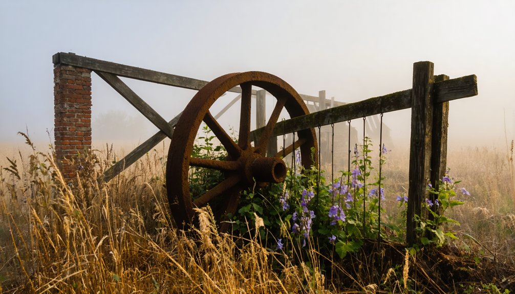
Pulling up to the Doris site today, you’ll find three weathered sentinels standing guard over what once thrived as a railway community—a shuttered whitewashed church, the crumbling shell of a creamery, and Buckhorn Cemetery’s tilted headstones.
These hauntingly preserved structures tell their stories without historical plaques or interpretive signs, leaving you free to wander and imagine what was. Shadrach Burleson donated the church land back in 1836, while the creamery recalls days when milk cans clinked in wagons and 2,000 folks gathered for annual picnics. At its peak, the creamery operated with 700 patrons served by 11 haulers covering 17 routes.
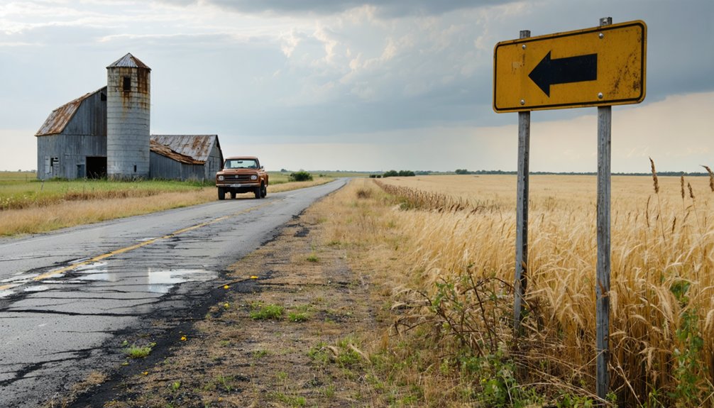
You can explore the weathered architectural features from outside—the structures remain private property—but that’s enough. Off Highway 64 in Jackson County, these creaking remains whisper louder than any marker could. Like many Iowa settlements, Doris faded when it was bypassed by railroads, a fate shared by other ghost towns across the state.
Notable Events From Doris’s Past
Few railway whistle-stops can claim the drama that unfolded along Doris’s brief stretch of track. In 1917, you’d have witnessed unexpected law enforcement activities when two thieves fleeing Independence chose this quiet hamlet as their hideout—only to be apprehended by pursuing lawmen. The Waterloo Times-Tribune documented every detail of the chase.
But nothing matched the tragic collision of September 30, 1922, when dramatic rail accidents forever marked Doris’s history. A train from Masonville rear-ended another at the siding, derailing both engines and killing one conductor while injuring two others. For a community that never exceeded twelve souls, these moments of chaos disrupted the peaceful rhythm of farming life along the Chicago and North Western Railway’s iron spine through Buchanan County. While Doris faded into obscurity, nearby Buckhorn thrived around a large creamery that became one of the Midwest’s leading butter producers. Similarly, Knowlton in Ringgold County once flourished as a railroad hub with around 450 residents before declining when a second rail line altered transportation patterns.
Understanding Why Doris Became a Ghost Town
You’ll notice Doris’s fate was sealed the moment its railroad lifeline could no longer sustain a one-industry town. After 1939, farming activities dwindled with alarming regularity, and the young folks who’d grown up alongside those stockyards started eyeing opportunities in Des Moines and Cedar Rapids.
What began as a trickle of families leaving for city jobs became an unstoppable tide, pulling residents away from the depot platform until no one remained to watch the trains pass through. Like Texola, which was established to accommodate railway expansion, Doris depended entirely on transportation infrastructure that eventually bypassed these small communities. Today, Iowa’s haunted landscape includes numerous structures with long histories—from old inns to asylums—that draw visitors fascinated by the blend of history and supernatural phenomena that defines the state’s ghost lore.
Railroad Dependency and Growth
The story of Doris’s rise and fall mirrors that of countless Iowa prairie towns that bet their entire future on the iron horse.
You’ll find that Doris flourished when trains stopped regularly, bringing passengers who needed meals, supplies, and lodging. Local businesses thrived on this steady traffic, creating jobs and prosperity throughout the community.
But railroad consolidation changed everything. When competing lines merged and streamlined operations, smaller depots became expendable. The Rock Island’s 1975 bankruptcy accelerated transportation infrastructure decline across rural Iowa.
Without those daily trains, Doris lost its economic lifeblood. Shops closed, families moved away, and the town that once buzzed with activity gradually emptied. You’re witnessing what happens when a community’s entire existence depends on rails that eventually bypass them.
Agricultural Decline After 1939
Standing in what remains of Doris today, it’s hard to imagine that agriculture—the very foundation of this prairie settlement—turned from prosperity to catastrophe in less than a decade.
After 1939, Jefferson County farmers faced a cruel paradox: surpluses and price drops devastated profits even as yields increased. Corn that averaged 39 cents per bushel couldn’t sustain family operations. The government’s response—paying farmers not to plant—contradicted everything these independent souls believed about working the land.
Meanwhile, mechanization and technological shifts transformed farming from a community endeavor into an industrial enterprise. Hybrid seeds and tractors replaced neighbors helping neighbors. Those who couldn’t afford the new equipment or survive the recurring price collapses simply walked away, leaving Doris without the farming families it desperately needed.
Rural Migration Patterns
Infrastructure changes sealed Doris’s fate. While larger towns got paved highways and modern services, Doris sat on a gravel road intersection that led nowhere important.
With Bethel just a mile west competing for the same dwindling resources, neither settlement stood a chance. From twelve residents in 1925 to complete abandonment by the 1990s, Doris represents freedom’s harsh reality—sometimes you’ve got to leave to survive.
Exploring Bethel: Doris’s Twin Town

Just down the road from where Doris once stood, Bethel emerged as its quieter twin, settling into Section 31 of Byron Township less than a mile to the west. You’ll find the two settlements were connected by more than Highway 939—they shared the same fate when rural migration emptied these communities after the early 20th century.
Unlike Doris, where every building’s been razed for cropland, Bethel still offers tangible remnants of frontier life. The old church cemetery remains your most significant landmark, standing as evidence, proof, or symbol to the congregation that gathered here from 1855 until 1939. Today, scattered farmhouses mark what’s left of this settlement, giving you something more than empty fields to contemplate during your visit westward along Nathan Bethel Avenue.
Other Ghost Towns to Visit Nearby
While Doris and Bethel offer compelling glimpses into Iowa’s vanished settlements, you’ll find the surrounding region riddled with similar ghost towns that tell their own stories of frontier ambition and inevitable decline.
Northeast Iowa’s unique regional landscapes hide several worthwhile stops:
- Donnan in Fayette County exists only as a memorial sign—a complete vanishing act that’ll make you ponder what else disappeared from these hills.
- Elkport in Clayton County offers minimal remains but authentic abandonment alongside Littleport and Motor.
- Buckhorn in Jackson County preserves historical buildings including a church, creamery, and cemetery from Shadrach Burleson’s 1836 founding.
- Rockville features a creepy Civil War-era cemetery and old mill ruins where eastern Iowa’s forgotten dreams still echo.
Each site rewards the curious traveler willing to venture down unmarked roads.
Best Routes and Directions for Your Visit
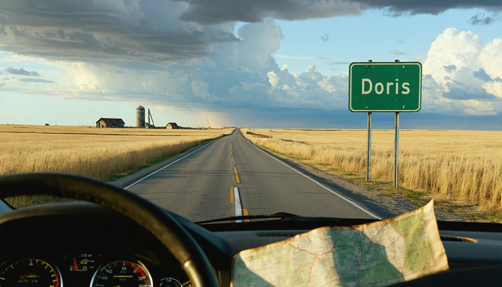
You’ll find Doris where Highway 939 crosses North Doris Avenue in central Buchanan County, though there’s precious little left to mark the spot except open farmland.
The beauty of visiting this ghost town lies in how easily you can pair it with Bethel, just a mile west on the same highway, making for a quick double feature of Iowa’s vanished whistle-stops.
In addition, exploring ghost town attractions in Donnan offers a unique glimpse into the past, allowing visitors to understand the stories behind abandoned buildings and faded streets. As you walk through the remnants of these once-thriving communities, you’ll uncover fascinating histories that often go untold. Don’t miss the chance to immerse yourself in the rich narrative of the area’s development and decline.
In contrast, exploring ghost towns in Wisconsin history reveals an entirely different chapter of America’s past. These sites serve as time capsules, preserving tales of pioneers and settlers who shaped the landscape. Each visit provides an opportunity to reflect on the resilience and challenges faced by those who once called these places home.
From Independence, head north on 939 until you reach the gravel road intersection—that’s Doris—then continue west to catch Bethel before the prairie swallowed it whole.
Accessing Highway 939 Crossing
Finding Doris requires traversing Buchanan County’s rural grid, where Highway 939 extends east-west through central Iowa farmland between the larger towns of Independence and Winthrop. You’ll discover the ghost town’s remnants at the intersection where North Doris Avenue crosses Highway 939, marked only by memory and landscape.
Navigating the crossing demands attention to gravel road conditions:
- North Doris Avenue remains an unimproved gravel stretch connecting the two communities
- The crossing sits just north of Highway 939 at coordinates 42°28′49″N 91°48′52″W
- You’ll find Bethel’s former site less than one mile westward near Nathan Bethel Avenue
- Three-fourths mile separates these abandoned railway whistle-stops
Watch for loose gravel and washboard ruts where century-old train passengers once disembarked into prairie wind.
Combining Nearby Ghost Towns
The gravel roads radiating from Doris’s crossroads create natural corridors to a constellation of vanished communities, each whistle-stop and forgotten townsite preserving fragments of Iowa’s railway-era settlement patterns. You’ll find Bryantsburg and Shady Grove within Buchanan County itself, while Donnan in adjacent Fayette County marks its existence with a solitary memorial sign.
Head northeast toward Clayton County’s floodplain cluster—Elkport, Littleport, and Motor—where mapping historical shifts reveals how the 2004 floods accelerated abandonment. Alternatively, venture southeast to Sunbury’s 1901 bank building and Buckhorn’s weathered creamery off Highway 64. These 100-200 mile loops connect communities that shared county courthouses and Friday night dances, tracing social dynamics through cemetery stones and crumbling foundations that railways once promised would become tomorrow’s thriving centers.
What to Expect When You Arrive
When your vehicle rolls to a stop at the intersection of Highway 939 and North Doris Avenue, you’ll find yourself surrounded by nothing but wind-swept farmland where Doris once stood. The complete absence of structures tells Doris’s story more powerfully than any historical markers or local preservation efforts could convey.
The endless farm fields stretching across the former town site where twelve souls once called home.
Silent gravel roads connecting to neighboring ghost town Bethel, barely a mile westward.
Scattered farmhouses dotting the distant landscape, survivors of the rural exodus.
Unobstructed prairie skies offering that rare solitude city-dwellers crave.
You’re free to wander this forgotten crossroads where Iowa’s agricultural heartland reclaimed its own.
Frequently Asked Questions
Are There Any Restrooms or Facilities Available Near the Doris Site?
No facilities exist at Doris—basic amenities lacking entirely at this forgotten prairie outpost. You’ll need portable toilets available in Waukon, fifteen miles away, where civilization still remembers modern conveniences. Plan accordingly before venturing into Iowa’s vanished past.
What Is the Best Time of Year to Visit Doris?
Visit Doris during fall when ideal weather conditions create perfect exploration temperatures and vibrant foliage frames abandoned structures. You’ll enjoy fewer seasonal tourist crowds than summer, giving you freedom to wander these forgotten prairie remnants at your own pace.
Do I Need Permission to Access the Former Doris Townsite?
Like wanderers respecting sacred ground, you’ll need to honor private property ownership here. Check local government regulations before exploring, as landowners’ rights matter. Most ghost town remnants sit on someone’s land—always ask permission first. Freedom means respecting boundaries.
Are There Any Hotels or Camping Options Near Doris?
You’ll find 54 lodging options within 30 miles of Doris, from cozy B&Bs to chain hotels. Nearby towns offer dining opportunities that’ll fuel your ghost town adventure. It’s the freedom of exploration with comfortable amenities close by.
Can I Find Any Original Artifacts or Relics at the Site?
You’ll find few visible artifacts today, though unexcavated historical foundations hide beneath prairie grass. Possible rare antique items occasionally surface after heavy rains, but most relics have vanished into private collections over decades of treasure hunters roaming freely through these forgotten homesteads.
References
- https://kids.kiddle.co/Doris
- https://www.youtube.com/watch?v=1J0Qx64ZrwI
- https://kids.kiddle.co/List_of_ghost_towns_in_Iowa
- https://www.crawfordcounty.iowa.gov/about/forgotten_towns/
- https://reformedjournal.com/2019/07/05/ghost-town-legacy/
- http://iagenweb.org/boone/land/towns-townships/towns_aban_towns.html
- https://en.wikipedia.org/wiki/Doris
- https://freepages.history.rootsweb.com/~gtusa/usa/ia.htm
- https://pubs.lib.uiowa.edu/annals-of-iowa/article/id/13329/download/pdf/
- https://genealogytrails.com/iowa/wayne/abandoned_towns.htm