Planning a ghost town road trip to Duncan, Colorado means committing to an adventure that starts in Silverton and winds 15 miles north into the San Juan Mountains. You’ll need a four-wheel-drive vehicle, offline GPS maps, and the right supplies before tackling the rugged final stretch to 10,400 feet. Visit between July and September for the best road conditions. From historic mining relics to the standing Duncan House, there’s far more waiting for those who dig deeper.
Key Takeaways
- Start your trip in Silverton, 15 miles south of Duncan, to fuel up, gather supplies, and rent necessary gear.
- A four-wheel-drive vehicle or ATV is required for the rugged 3.5-mile final stretch to Duncan.
- Download offline maps and GPS coordinates (37.8954 N, 107.6221 W) before leaving, as cell service is unavailable in the backcountry.
- Visit between July and September for the most reliable road conditions and safest mountain access.
- Explore the Duncan House, original mill pads, mining relics, and a nearby restored jailhouse during your visit.
What Makes Duncan, Colorado Worth the Drive?
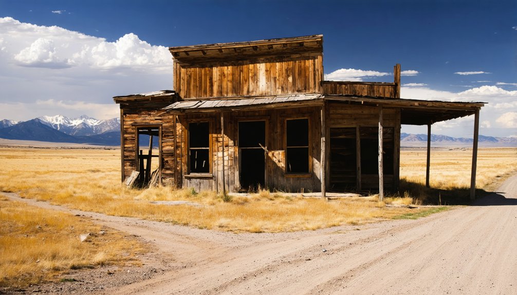
Duncan, Colorado isn’t your typical ghost town pull-off—it demands a real commitment, rewarding you with raw, 10,400-foot mountain scenery, preserved 19th-century wooden architecture, and scattered mining relics that most tourists never bother to seek out.
Duncan history stretches back to the late 1870s silver boom, when pioneer families carved a working settlement into these rugged San Juan peaks. That mining legacy still breathes through rusty equipment, original mill pads, and the standing Duncan House—a rare survivor from an era when silver ruled this valley.
You’ll share the landscape with marmots, pika, and wildflower meadows while standing where thousands once chased fortune. If you crave destinations that trade crowds for authenticity and easy pavement for something earned, Duncan delivers exactly that.
How to Get to Duncan From Silverton?
Your journey to Duncan begins in Silverton, a charming mountain town about 15 miles south of the site that serves as your last chance to fuel up, grab supplies, and rent any gear you’ll need.
From there, you’ll head north on US Highway 550 before turning onto County Road 2, where GPS navigation becomes essential since cell service vanishes quickly in the backcountry.
The final 3.5-mile stretch of unpaved road throws steep grades and loose rock at you, so you’ll want a four-wheel-drive vehicle or ATV to make it safely to the site.
Starting Point In Silverton
Nestled in the heart of the San Juan Mountains, Silverton serves as your launching pad for the drive to Duncan. Before hitting the road, take time to soak in Silverton history — this rugged mining town thrived during the same 1870s silver boom that built Duncan. Its preserved Victorian storefronts and mining-era museums set the mood perfectly for what’s ahead.
Stock up on supplies here, since you won’t find services once you leave town. Grab extra water, food, and a first-aid kit from local shops before you go.
From Silverton, head north on US Highway 550, where scenic landscapes of towering peaks and glacial valleys unfold immediately. You’ll then turn onto County Road 2, marking the true beginning of your backcountry adventure toward Duncan.
Once you turn onto County Road 2, the pavement quickly disappears beneath your tires, replaced by roughly 3.5 miles of steep grades and loose rock that demand full attention.
Road conditions here aren’t forgiving — ruts, exposed boulders, and narrow switchbacks test both your nerves and your rig.
Vehicle requirements aren’t suggestions; you’ll need a four-wheel-drive vehicle or ATV to safely navigate the climb. A standard sedan will leave you stranded before you get close.
Cell service vanishes completely, so download offline maps and load GPS coordinates (37.8954 N, 107.6221 W) before leaving Silverton.
Pack extra water, food, and a first-aid kit — there’s nothing out here if something goes wrong.
Stick to summer or early autumn, when snow isn’t blocking your path to Duncan.
Final Unpaved Road Stretch
As the rocky terrain of County Road 2 gives way to the final stretch toward Duncan, you’ll feel the mountain asserting itself — loose shale shifts beneath your tires, steep grades push your engine hard, and narrow passages leave little room for error.
This 3.5-mile unpaved challenges section demands your full attention and a capable four-wheel-drive vehicle.
But the scenic rewards arrive quickly. Talus slopes rise dramatically on either side, wildflower meadows spill across open benches, and the remnants of an 1880s mining world slowly come into view.
Keep your speed controlled, your eyes forward, and your windows down — the crisp alpine air at 10,400 feet reminds you exactly why you traded pavement for freedom.
Duncan doesn’t come easy, but it absolutely comes worth it.
When Is Duncan Accessible and What Closes the Road?
Timing your visit to Duncan is everything, because winter conditions can shut the road down entirely for months at a stretch. Snow and ice make the steep, rocky approach impassable from late autumn through late spring, so you’ll want to plan around summer and early autumn for the best seasonal access.
July through September typically offers the most reliable road conditions, with drier weather and longer daylight hours giving you more freedom to explore at your own pace.
July through September brings the driest roads and longest days, giving you the most flexibility to explore.
Even then, afternoon thunderstorms can roll in fast at 10,400 feet, turning loose rock into slick hazards.
Before heading out, check with Silverton locals or the San Juan National Forest office for current conditions. That quick call could save you a frustrating turnaround miles from your destination.
What You’ll See at the Duncan House and Mining Site?
When you finally pull up to the Duncan site, the Duncan House immediately commands your attention as the most intact structure from the original 19th-century mining era. Its preserved wooden frame stands as a rare survivor of the silver boom that once drove thousands into these mountains.
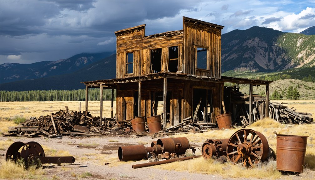
Beyond the house, you’ll notice the original mill pads sitting adjacent to the structure, their stone foundations still remarkably defined. Scattered across the grounds, mining relics from the 1880s operations rust quietly in the thin alpine air, telling stories without a single word.
A short footpath leads you toward a restored jailhouse nearby. Talus slopes frame the entire scene, where marmots dart between rocks. Every corner of this site rewards the curious explorer who appreciates raw, unfiltered history.
What to Pack for the Road Up to Duncan?
The 3.5-mile unpaved climb to Duncan demands that you pack smart before you leave Silverton behind. Steep grades, loose rock, and zero nearby services mean your packing essentials can make or break the trip. Toss extra water, food, and a first-aid kit into your vehicle without negotiating.
Weather considerations deserve equal attention. At 10,400 feet, afternoon thunderstorms roll in fast, so layer up and bring waterproof gear even on sunny mornings. Temperatures can drop sharply once clouds build over the San Juans.
At 10,400 feet, storms build fast—layer up and pack waterproof gear, even when mornings look clear.
Since cell service is nonexistent, download offline maps and carry a GPS device. Also pack tools for a basic roadside repair, because a flat tire on that backcountry road isn’t the adventure you planned.
Prepare thoroughly, and the drive rewards you completely.
Which Ghost Towns and Scenic Stops Pair Well With Duncan?
Once you’ve explored Duncan, you’re already within striking distance of Animas Forks, a public ghost town just 1.5 miles away where you can walk through a restored saloon and hotel.
The Alpine Loop Scenic Byway then extends your adventure with a 12-mile off-road route that winds through the broader San Juan valley, connecting several historic mining sites.
Pairing these stops with your Duncan visit turns a single-site trip into a full day of high-altitude exploration without adding significant mileage.
Nearby Ghost Town Visits
Pairing your Duncan visit with nearby ghost towns turns a single stop into a full-day backcountry adventure. You’ll find rich ghost town experiences just miles away, each carrying its own historical significance and untamed mountain character.
- Animas Forks sits 1.5 miles away, offering public access to a restored saloon and hotel you can actually explore.
- Alpine Loop Scenic Byway delivers a 12-mile off-road route connecting multiple abandoned mining sites across the valley.
- Crater Lake rests three miles north of Duncan via dirt road, rewarding drivers with stunning high-altitude scenery.
- Silverton anchors your trip 15 miles south, providing museums, gear rentals, and dining before you head into the backcountry.
Stack these stops strategically, and you’ll maximize every mile of your mountain adventure.
Scenic Byway Side Trips
Stretching your Duncan visit into a full scenic byway adventure means trading a single ghost town stop for a connected chain of high-altitude history and raw mountain beauty.
The Alpine Loop Scenic Byway delivers 12 miles of off-road terrain packed with scenic viewpoints overlooking valley floors carved by glaciers and mining ambition. You’ll move freely between historic landmarks, connecting Duncan with Animas Forks and pushing further toward Engineer Pass if your vehicle handles it.
Crater Lake sits three miles north, rewarding drivers with glassy alpine reflections framed by jagged peaks. Silverton anchors the southern end, offering fuel, food, and museum stops before you head back into the backcountry.
String these destinations together, and you’ve built a road trip that earns every mile.
What Are You and Aren’t You Allowed to Do at Duncan?
Before you explore Duncan, it’s worth knowing the rules that keep both visitors and the site safe. Respecting Duncan etiquette and practicing wildlife awareness guarantees this fragile historical site stays accessible for future adventurers.
- Stay on designated paths to avoid unstable terrain and structural hazards.
- Leave your camping gear at home — no overnight stays are permitted on private property.
- Keep dogs leashed, since marmots and pika inhabit the surrounding talus slopes.
- Fly drones no lower than 100 feet above ruins and wildlife.
You’re welcome to photograph everything you discover, but tread carefully around aging wooden structures.
The freedom to explore places like Duncan depends entirely on how responsibly you treat them. Carry out everything you bring in, and leave the site exactly as you found it.
Frequently Asked Questions
Is There Any Entrance Fee to Visit the Duncan Site?
You won’t pay an entrance fee to explore Duncan’s historical significance, but remember it’s private property. Respect accessibility options by staying on designated paths, embracing your freedom responsibly while discovering this remarkable 19th-century mining heritage.
Are Restroom Facilities Available Near the Duncan House Parking Area?
You won’t find restroom facilities or visitor amenities near the Duncan House parking area, so plan accordingly! There’s no restroom maintenance out here — pack out what you bring and embrace the wild, untamed freedom of Colorado’s backcountry.
How Long Does a Typical Visit to Duncan Usually Take?
You’ll typically spend one to two hours exploring Duncan’s history — and it’s no coincidence that’s just enough time to soak it all in. Follow these travel tips: arrive early, stay curious, and you won’t regret it.
Can Children Safely Visit Duncan Given the Terrain and Elevation?
Yes, children can visit Duncan if you’re prepared! Assess your child’s readiness for 10,400-foot elevation and rugged terrain. Follow safety measures like staying on paths, carrying water, and keeping little explorers close throughout your adventure.
Is Duncan Visible From the Main Road Without Hiking to It?
You won’t spot Duncan’s ghost town visibility from the main road without venturing closer. Your road trip accessibility improves once you navigate the 3.5-mile unpaved route, revealing the preserved Duncan House tucked among stunning mountain terrain.
References
- https://k99.com/haunted-road-trip-10-ghost-towns-you-can-drive-to-in-colorado/
- https://999thepoint.com/the-ultimate-ghost-town-road-trip-through-colorado/
- https://www.colorado.com/articles/colorado-ghost-towns
- https://www.youtube.com/watch?v=JfBPNW1fb7U
- https://www.4x4explore.com/dest/dest_ghst.htm
- https://www.nationalgeographic.com/travel/article/ghost-towns-colorado-road-trip
- https://www.facebook.com/groups/coloradodaytrips/posts/3430829967047006/
- https://www.onlyinyourstate.com/trip-ideas/colorado/co-ghost-town-road-trip
- https://www.reddit.com/r/Colorado/comments/1eux9o/looking_for_ghost_towns/
- https://jwdurango.com/unlock-eureka-road-easy-access-ghost-town-tips-epic-photos/


