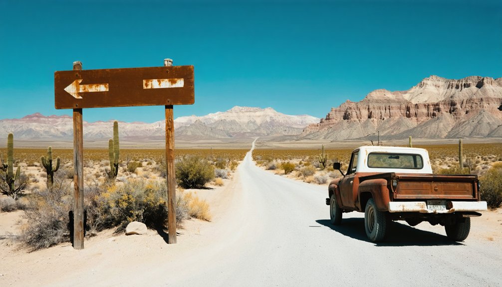
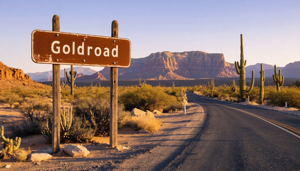
You’ll find Goldroad clinging to Arizona’s Black Mountains along a white-knuckle eight-mile stretch of original Route 66, where 191 curves snake past crumbling stone houses and rusted mining equipment. Keep your speed under 15 mph on the hairpin turns—this narrow, shoulderless route isn’t forgiving, and wild burros still wander the pavement. Plan 90 minutes from Oatman to Kingman, and watch for century-old mine shafts pockmarking the landscape where $7.3 million in gold once emerged from the hills beneath your wheels.
Key Takeaways
- Goldroad sits on an eight-mile stretch of historic Route 66 between Cool Springs and Oatman, featuring 191 curves and hairpin turns.
- Navigate the narrow, shoulderless road at speeds under 15 mph and use vehicles under 25 feet for safety on steep grades.
- Allow 90 minutes for the drive from Oatman to Kingman and watch for wild burros wandering the pavement.
- Explore crumbling remnants including the Onetto and Patterson houses, Gold Road Garage skeleton, and weathered mining equipment throughout the canyon.
- A working gold mine still operates 275 feet beneath Route 66, with century-old mine shafts dotting the surrounding landscape.
The Discovery That Started It All: Jose Jerez and His Lost Burro
While chasing a wandering burro through the Black Mountains in spring 1900, Mexican prospector Jose Jerez literally stumbled over a gold-bearing quartz ledge near Sitgreaves Pass that would transform the Arizona desert.
Jose Jerez’s grubstake arrangement was modest—just $16 from Kingman store owner Henry Lovin funded his search for that wayward pack animal. The burro’s role in the gold discovery proved invaluable; without tracking its trail, Jerez never would’ve found the rich vein assaying at 40 ounces of gold per ton.
You’ll appreciate the prospector’s resourcefulness. After digging a 15-foot shaft, he packed ore samples to town and sold his claims for $50,000 in 1901. The claims changed hands again when investors purchased them for $275,000 to another group. That lost burro created fortunes for California investors while Jerez, tragically, drank away his wealth in Lovin’s Gold Road Club saloon. His discovery sparked a mining boom that dotted the area near Kingman with thriving mining towns throughout the early 20th century.
From Boomtown to Ghost Town: A Timeline of Goldroad’s Rise and Fall
Jerez’s windfall sparked a frenzy that transformed this remote desert outpost from a single 15-foot shaft into Arizona’s richest gold camp within five years. By 1905, 180 miners were pulling $2 million in gold annually from these hills, processing 150 tons of ore daily through cyanide mills. The company town boasted a post office, hundreds of residents, and even piped water from distant springs—no small feat in this unforgiving landscape.
But boom turned to bust when rich veins depleted by 1907. The mine limped along intermittently until 1931, then sporadically revived when gold prices climbed. WWII’s federal moratorium delivered the final blow in 1942, creating the ghost town you’ll explore today. Over its lifetime, the operation extracted over 750,000 ounces of gold from the surrounding mountains. Despite enduring mining challenges and several modern revival attempts, Goldroad’s lasting community impact remains frozen in time along Route 66. In 1992, Addwest Minerals purchased the Gold Road Mine and reopened its shafts with a newly built mill for extracting gold.
The eight-mile stretch of old Route 66 between Cool Springs and Oatman doesn’t just test your nerves—it earns its nickname as the “Arizona Sidewinder” with 191 curves snaking through the Black Mountains. You’ll climb 2,100 feet through high elevation switchbacks to Sitgreaves Pass at 3,550 feet, where scenic overlooks reveal the serpentine road you’ve conquered below.
Keep your speed under 15 mph on hairpin turns—this narrow, shoulderless route isn’t forgiving. In the 1930s, Model T drivers actually reversed up Gold Hill Grade because their fuel systems couldn’t handle the steep grades forward. Plan 90 minutes from Oatman to Kingman, and stick to vehicles under 25 feet. Watch for wild burros wandering the pavement and century-old mine shafts dotting the landscape. Along this challenging stretch, you’ll pass recently reactivated gold mine workings that hint at the area’s mining legacy. This route once served as the main east-west thoroughfare through the region before Interstate 40 replaced it.
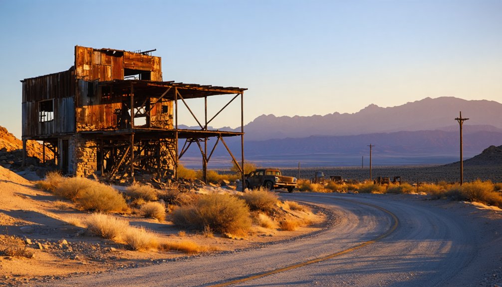
What You’ll Find: Exploring the Ruins and Remnants
After conquering those hairpin turns, you’ll need sharp eyes to spot Goldroad’s remains—these native stone ruins camouflage perfectly against the rocky gulches clinging to the hillside. Scan carefully and you’ll discover prominent architectural remains: crumbling walls from the Onetto and Patterson houses, cement stairs leading nowhere, and the roofless Gold Road Garage skeleton. The Summit Gas Station’s foundation sits charred from its 1967 blaze.
Venture into the surrounding hills for weathered mining equipment and old shafts pockmarking the landscape. For $5, you can tour a working gold mine that tunnels 275 feet beneath Route 66 itself. Rock retaining walls terrace the canyon slopes where this 1903 boomtown once thrived. This company town housed miners, support personnel, and their families who worked the multiple gold mines scattered throughout the area. The mines petered out and the town died just after World War II, leaving behind these weathered remnants. Everything feels raw and untamed—exactly what you’re seeking beyond civilization’s grip.
The Gold Road Mine: $7.3 Million in Treasure
Fortune smiled on Jose Jerez in 1900 when a chunk of quartz he’d chipped from these hills assayed at 40 ounces of gold per ton—an astonishing strike that would transform this desolate stretch of Arizona into one of the richest mining districts in the Southwest.
A single quartz sample yielding 40 ounces per ton launched Arizona’s transformation into a Southwest mining powerhouse.
The mine’s legendary production tells the story:
- Tourist boom years (1904-1907) saw the Vivian Mining Company extract over $3 million using cutting-edge mining innovations
- Peak output reached 140,625 ounces worth $2,250,000 by 1907
- Total haul topped $7.3 million when operations ceased in 1937, with nearly 750,000 ounces pulled from the earth
United States Smelting & Refining bought the operation for $1.6 million in 1911. The mine had already produced $6,654,050 in gold by 1915, showcasing the extraordinary wealth of this deposit. Modern miners extracted another 92,500 ounces during the 1990s revival, proving there’s still gold in these hills. When Addwest Minerals took control in 1992, they ramped up production to 40,000 ounces in 1996 before low gold prices forced a temporary shutdown in 1998.
Wild West Justice: The Violent Events of 1905
While fortunes were being pulled from the earth in 1905, Goldroad’s streets ran red with violence. You’ll discover the notorious Bad Lands district housed laborers in core Goldroad, where Jennie Bauters operated gambling establishments.
That September, Clement C. Leigh—posing as her husband—arrived demanding money, sparking a deadly chase. He shot Bauters twice, paralyzing then killing her before turning his gun on himself. He survived.
Wild mining camp unrest exploded with two murders within ten days that fall. Frontier lawlessness in Goldroad peaked alongside record production—ironically, the same year they built a grammar school and hospital. The company even produced Arizona Territory’s second-largest gold bar: 243 pounds worth $50,000.
Progress and chaos coexisted in this furious, violent boomtown where justice came swift and brutal.
Hollywood History: Goldroad’s Cameo in The Grapes of Wrath
Standing where John Ford’s camera crew captured the Joad family’s desperate westward journey, you’re witnessing a slice of cinema history that transformed Goldroad’s treacherous switchbacks into an icon of Depression-era migration. Cinematographer Gregg Toland filmed these location highlights during October 1939, capturing the Grade’s 3,523-foot summit as Tom Joad crossed Arizona toward California’s promised land.
What makes these scenic filming locations legendary:
- The hairpin turns you’ll navigate are identical to those in the 1940 film’s final cut
- Route 66’s original narrow corridor remained unchanged until 1952, preserving Ford’s authentic vision
- The Colorado River crossing at Topock completed Arizona’s filming sequence before Interstate 40 replaced this freedom road
You’re driving the same “road of hope” that defined America’s greatest migration story.
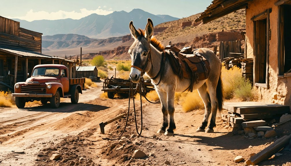
Combining Your Visit: Pairing Goldroad With Oatman
After exploring where Hollywood immortalized Route 66’s dusty promise, you’ll find Goldroad’s real treasure lies just two miles west—the living ghost town of Oatman. This pairing transforms a quick roadside stop into genuine road trip highlights worth the canyon drive.
You’ll experience the contrast: Goldroad’s lonely water tanks and crumbling mine shafts whisper secrets to sagebrush, while Oatman thrives with 500,000 annual visitors feeding burros on wooden boardwalks.
Start at Goldroad’s ruins where you’ll have the desert to yourself, then roll into Oatman’s visitor foot traffic for cold drinks and the Gold Mine Museum’s authentic shaft entrance.
The two-mile stretch captures Arizona’s complete gold rush story—from abandoned dreams rusting in silence to boomtown swagger that refused to die.
Photography and Viewpoints: Capturing Desert Vistas
Goldroad’s rugged terrain rewards photographers who time their visits for golden hour, when low-angle sunlight transforms weathered adobe ruins into glowing amber subjects against the Black Mountains’ dark volcanic backdrop.
Position yourself at the upper east end of town to frame hollow stone shells and mine tailings, then shift to Sitgreaves Pass viewpoints where Thimble Butte punctures the eastern horizon like a natural obelisk.
The narrow roadway itself becomes your foreground element—capture hairpin turns plunging toward desert valleys, or shoot through rock openings where seeping water creates unexpected pockets of green algae against sun-baked stone.
Best Overlook Photography Spots
The summit of Sitgreaves Pass at 3,550 feet delivers the money shot that’ll make your photography buddies jealous—a sweeping westward panorama across the Colorado River valley from a cliff edge that drops away in dramatic fashion. Turn around and you’ll frame Thimble Butte’s sharp profile rising against the eastern sky.
Three can’t-miss vantage points:
- Hairpin turns before Cool Springs – These switchbacks create natural frames with picturesque mountain vistas layering into the distance
- Terraced ruins above Route 66 – Goldroad’s ghost town remnants offer elevated perspectives over the mining district
- Roadside pull-offs near seeping rock pools – Algae-covered stones add unexpected foreground interest to dramatic cliff overlooks
The narrow blacktop’s lack of shoulders means you’ll need to time your stops carefully between traffic on this 1926-vintage stretch.
Golden Hour Lighting Tips
When Route 66 carves through Goldroad’s sun-scorched terrain, you’ll want to time your camera work for the hour after sunrise or before sunset—those magical windows when horizontal light rakes across the desert floor like honey dripping over stone. Position yourself for frontlit compositions by keeping the sun at your back, illuminating abandoned structures in warm amber tones that reveal every weathered plank and rusted bolt.
Alternatively, experiment with backlighting techniques by shooting directly into the sun, silhouetting crumbling buildings against blazing skies while creating dramatic depth through shadow play. Pack your tripod and dial in settings around f/14, ISO 100, and 1/20 second to nail proper exposures. Those long shadows stretching across sandy washes? They’re not obstacles—they’re your compositional anchors.
Historic Ruins Camera Angles
Beyond the ghost town’s crumbling walls, your widest lens becomes essential for capturing the full sweep of California’s distant mountains from Goldroad Canyon’s vantage points. Position yourself along Route 66’s hairpin turns where roofless structures create dramatic silhouettes against desert skies.
Three angles that’ll transform your ruins photography:
- Frame Thimble Butte’s sharp peak behind Cool Springs’ reconstructed rock buildings for compelling building composition with natural depth
- Shoot from elevated hairpin curves looking down at water tanks and cement stairs blending into canyon terrain
- Enter dark building interiors with a tripod, using window light to illuminate crumbling walls and mining artifacts
The schoolhouse museum permits tripods, but pack light—these hills demand mobility. Slow down approaching old mining shafts; they’re your gateway to authentic close-up perspectives.
Safety Tips for Exploring Abandoned Mine Shafts and Structures
Although Goldroad’s weathered buildings and silent mining equipment beckon curious explorers, you need to understand that these remnants represent genuine life-threatening hazards, not nostalgic photo opportunities. Effects of weathering on structural integrity have transformed once-solid timbers into crumbling traps, while vertical shafts hidden beneath rotting boards can plunge you hundreds of feet.
I’ve watched mine rescue team safety protocols in action—these experts risk their lives because adventurers ignored the dangers. Stay outside fenced areas, never test wooden structures with your weight, and keep children within arm’s reach. Oxygen-deficient gases accumulate silently in unventilated spaces beyond 100 feet deep. Water-filled pits conceal deadly drop-offs beneath deceptively calm surfaces.
Photograph Goldroad’s history from safe distances—your freedom means nothing if you’re trapped underground awaiting recovery teams.
Frequently Asked Questions
What Amenities Are Available Near Goldroad for Food, Gas, and Lodging?
You’ll find nearby dining options in Oatman’s quirky cafes, while Kingman offers full services 30 miles away. Available camping sites exist in surrounding areas, though you’ll need to pack provisions for true ghost town exploring freedom.
Is There an Entrance Fee to Visit Goldroad Ghost Town?
You’ll discover Goldroad stands open like an old prospector’s welcome—no entrance fee chains your exploration. Check seasonal visitor hours before venturing out, though no permit requirements bind you. Free admission lets you wander this desert relic at will.
What Is the Best Time of Year to Visit Goldroad?
Visit Goldroad during winter months (December-February) for ideal weather conditions and the ideal tourist season. You’ll enjoy comfortable 66-71°F highs perfect for exploring ruins, while summer’s brutal 106°F heat makes outdoor adventures dangerously uncomfortable.
Are Pets Allowed When Exploring the Goldroad Site?
You’ll find Goldroad’s pet-friendly policies welcome leashed dogs throughout outdoor areas. While on-site pet accommodations are limited, you’re free to explore dusty streets with your furry companion. Just avoid indoor buildings and bring water for desert adventures.
How Long Should I Plan to Spend Exploring Goldroad?
Plan 2-3 hours minimum for Goldroad exploration. Your walking speed will slow considerably given rugged site conditions—steep gulches and camouflaged ruins demand careful navigation. Budget extra time; you’ll want freedom to discover hidden foundations at your own pace.
References
- https://www.legendsofamerica.com/az-goldroad/
- https://www.arizonahighways.com/article/arizona-ghost-towns
- https://www.cornerstone-environmental.com/publications/item/goldroad-and-the-oatman-mining-district
- https://www.apcrp.org/GOLDROAD/1000 Goldroad Rev.htm
- https://desertwondertours.com/oatman-arizona-where-gold-built-a-legend-in-the-black-mountains/
- http://freepages.rootsweb.com/~gtusa/history/usa/az/goldroad.htm
- https://www.deseret.com/2000/1/23/19487244/oatman-goes-from-mining-town-to-tourist-lure/
- https://www.hmdb.org/m.asp?m=50762
- https://www.theroute-66.com/oatman.html
- https://www.latimes.com/travel/la-tr-escape27oct27-story.html


