To reach Hale’s abandoned coal mining site in Delaware County, you’ll navigate Highway 412 through Chouteau, then follow winding county roads into dense oak forests where crumbling foundations and toxic chat piles mark this once-thriving boomtown. Bring a high-clearance vehicle for rough dirt paths, and stop at Colcord’s gas station for directions since GPS often fails here. The Quapaw Tribe now controls this contaminated landscape dotted with 14,000 abandoned mine shafts, so understanding the indispensable safety precautions and historical context becomes critical before you venture into Oklahoma’s most hazardous ghost town.
Key Takeaways
- Access Hale via Highway 412 through Chouteau, then winding county roads requiring a high-clearance vehicle for rough terrain.
- The site contains 14,000 abandoned mine shafts and contaminated landscape now controlled by the Quapaw Tribe undergoing restoration.
- Avoid toxic chat piles and mine seepage; ground subsidence poses cave-in risks throughout the former coal mining area.
- No services exist at the ghost town; bring sufficient fuel, food, water, and emergency supplies for your visit.
- Nearby abandoned towns include Picher, Gray Horse, Sparks, Centralia, and Blackburn for additional exploration opportunities.
Getting to Hale: Your Route From Tulsa
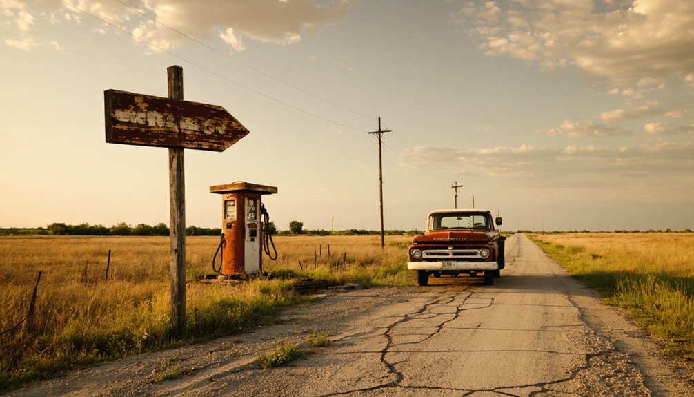
Although Hale doesn’t appear on modern GPS systems, you’ll find this forgotten settlement about 90 miles northeast of Tulsa, tucked into the wooded hills where Delaware and Mayes counties meet. Take Highway 412 east through Chouteau, then navigate the winding county roads that slice through dense oak forests. You’ll need to rely on old paper maps and local lore to pinpoint the exact location—ask at the nearest gas station in Colcord for directions.
The journey itself becomes part of the adventure. Watch for crumbling stone foundations and weathered fence posts marking long-abandoned homesteads. What remains of Hale’s historic buildings hides behind overgrown vegetation, accessible only by rough dirt paths. Bring a high-clearance vehicle and prepare for an authentic backcountry exploration.
The Rise and Fall of a Coal Mining Boomtown
Long before Hale became a name whispered among ghost town enthusiasts, French explorer Bernard de La Harpe spotted something remarkable along Coal Creek in 1719—black rock jutting from the red Oklahoma soil. That coal would fuel empires and enslave generations.
When the Katy Railroad punched through in 1872, everything changed. Coal barons built fenced camps where miners—often inexperienced immigrants—received scrip instead of cash, trapping them in debt. “Bob-tail” checks became routine when deductions exceeded earnings.
The environmental impact stretched across 32,000 surface acres and 40,000 underground.
The 1903 watershed agreement cracked their feudalistic grip. Statehood in 1907 finished it. By the Depression, these once-thriving camps stood empty—monuments to exploitation disguised as opportunity.
What Remains at the Hale Ghost Town Site Today
When you roll into Hale today, the silence hits first—no grinding machinery, no shouting miners, just wind pushing through skeletal structures and knee-high weeds claiming the street grid. A handful of buildings still stand amid orange-tinted chat piles that tower over what’s left.
The Quapaw Tribe now controls much of this contaminated landscape, coordinating environmental restoration efforts where children once played with lead in their bloodstreams. You’ll spot water quality monitoring stations scattered throughout—silent sentinels tracking heavy metals still leaching from 14,000 abandoned mine shafts below your feet.
The ground itself remains hollow, utilities long terminated, foundations constantly threatened by cave-ins. Stay on public roads, keep your windows up, and whatever you do, don’t wander into those debris fields.
Exploring Other Abandoned Towns in the Region
The chat piles don’t stop at Hale’s borders—they ripple across northeastern Oklahoma like rust-colored monuments to extraction, marking ghost towns that share Hale’s toxic legacy. Picher’s federal evacuation stands as the most dramatic example—thousands bought out, structures bulldozed, lead poisoning finally acknowledged.
You’ll find quieter abandonments nearby: Gray Horse preserves the hidden history of Osage County through its cemetery and weathered buildings, while Sparks showcases cultural remnants of Sac and Fox Reservation lands dissolved in 1890. Centralia’s prairie ruins sit on Blue Mound’s elevation, and Blackburn recalls the Cherokee Outlet land run chaos. Each stop tells the same story—boom, extraction, collapse—visible in sagging rooflines and empty main streets that nobody bothered to reclaim.
Essential Safety and Planning Advice for Your Visit
Before you drive into Hale’s skeletal remains, understand that visiting this ghost town isn’t like touring sanitized historical sites with gift shops and guardrails. Reducing environmental exposure risks means avoiding contact with chat piles and staying upwind of toxic dust. Addressing ground subsidence concerns requires sticking to main routes—some roads have literally swallowed vehicles into underground mine shafts.
Critical preparations:
- Navigate defensively: Heavy trucks are banned here for good reason. Those innocent-looking roads hide hollow caverns that’ve collapsed houses overnight.
- Pack emergency supplies: No services exist. Commerce or Miami are your nearest resources for fuel, food, and help.
- Respect contamination zones: That orange-stained water isn’t rust—it’s toxic mine seepage that once turned children’s hair orange.
You’re exploring America’s most contaminated ghost town. Plan accordingly.
Frequently Asked Questions
Are There Any Guided Tours Available for Hale Ghost Town?
No guided experiences available exist for Hale itself, but you’ll find freedom exploring independently. Nearby Guthrie offers private tours offered through ghost walks, while self-guided apps let you roam Creek County’s abandoned sites on your own terms.
What Photography Equipment Works Best for Documenting Ghost Town Ruins?
You’ll want a wide-angle lens (16-35mm) for cramped interiors and a sturdy tripod for low-light shots. My lens selection captures doorways perfectly, while tripod recommendations guarantee sharp exposures in Hale’s dim buildings without lugging excessive gear.
Can I Camp Overnight Near the Hale Site?
You’ll need camping permits for overnight accommodations near Hale, but options are limited. Your closest bet is Optima NWR’s ghost campground, 150 miles northwest, offering concrete pads for dispersed camping without amenities—perfect for off-grid freedom seekers.
Are There Any Local Museums With Hale Artifacts or Historical Displays?
You won’t find dedicated Hale ghost town artifacts in museums, but Oklahoma’s Federal Judicial Learning Center displays Osage Reign of Terror exhibits. Check local history archives and oral history interviews for deeper connections to this vanished community’s past.
What Cell Phone Coverage Can I Expect in the Area?
Unlike telegraph lines of yesteryear, you’ll find decent coverage from major carriers near Yale. However, expect spotty signal strength as you venture toward Hale’s ruins. Watch for roaming limitations if you’re exploring remote backroads beyond civilization’s reach.


