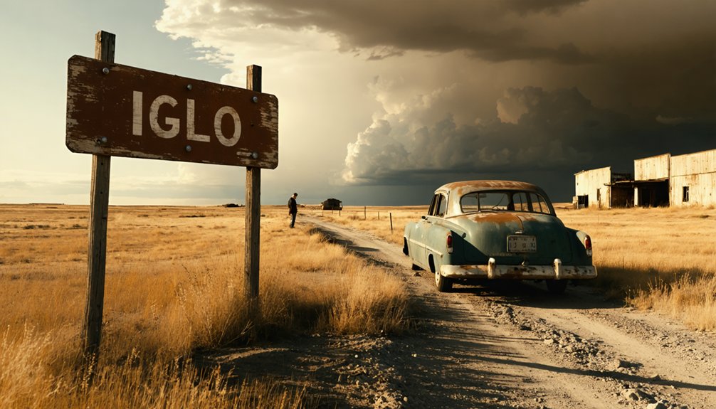
Planning a ghost town road trip to Igloo, South Dakota, starts eight miles south of Edgemont, where 801 earth-covered bunkers sprawl across 33 square miles of rolling plains. This former World War II munitions depot stored everything from conventional explosives to chemical weapons before closing in 1967. You can explore freely year-round, though spring and fall offer the most comfortable conditions. Pair it with Wind Cave, Custer State Park, and the Mammoth Site in Hot Springs for a full Black Hills adventure worth uncovering.
Key Takeaways
- Igloo, South Dakota, is a ghost town eight miles south of Edgemont, featuring 801 earth-covered bunkers from a 1942 military depot.
- Visit during late spring through early fall for comfortable temperatures, ideal lighting, and easier navigation across the 33-square-mile site.
- Plan one to two hours on-site, combining the visit with nearby attractions like Wind Cave, Custer State Park, and the Mammoth Site.
- Some areas are privately leased by Vivos xPoint survival community, so stay on accessible roads and maintain awareness of armed residents.
- Pack sturdy shoes, water, sun protection, a flashlight, and a fully charged phone with a paper map as backup.
What Is Igloo, South Dakota?
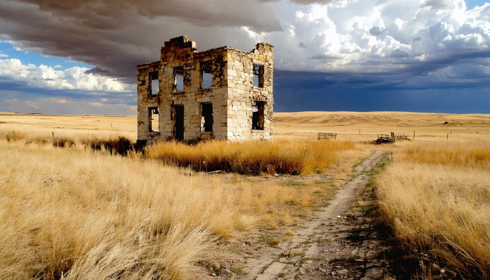
Tucked into the remote plains of Fall River County in southwestern South Dakota, Igloo is a ghost town unlike any other — a former military community built around 801 igloo-shaped concrete bunkers that once stored some of the most dangerous munitions of the 20th century.
Established in 1942 as the Black Hills Ordnance Depot, it housed up to 6,000 workers and soldiers at its peak. The town earned its name from those distinctive earth-covered bunkers, and Igloo Legends surrounding its secretive past still fuel curiosity today.
Community Myths about what was stored here — conventional explosives, mustard gas, and sarin agent — aren’t myths at all.
After closure in 1967, the town was abandoned and razed, leaving behind a haunting landscape that you can still explore today.
The Explosive History Behind Igloo’s 801 Bunkers
When you stand among Igloo’s 801 earth-covered bunkers, it’s easy to forget you’re looking at one of World War II’s most critical — and dangerous — infrastructure projects. Established in 1942 as the Black Hills Ordnance Depot, this remote South Dakota site stored conventional explosives, mustard gas, and sarin agent — materials that demanded serious bunker architecture to contain safely.
Built in 1942 to store mustard gas and explosives, these 801 bunkers were engineered for one purpose: controlled danger.
The igloo-shaped concrete structures, sealed with steel doors and blanketed in sod, weren’t just functional — they were engineered for isolation and temperature control.
At peak operation, 6,000 workers and soldiers called this place home.
After closure in 1967, nature and silence reclaimed the land.
Today, that same rugged self-sufficiency draws devotees of survivalist culture, who see these Cold War relics as ready-made refuges for an uncertain future.
Where Is Igloo, South Dakota, and How Do You Get There?
Finding Igloo isn’t exactly a GPS-friendly adventure — it sits in Fall River County, deep in southwestern South Dakota, eight miles south of the small town of Edgemont at coordinates 43.3833, -103.8333.
This remote Igloo geography is no accident; military planners deliberately chose isolation for maximum munitions security.
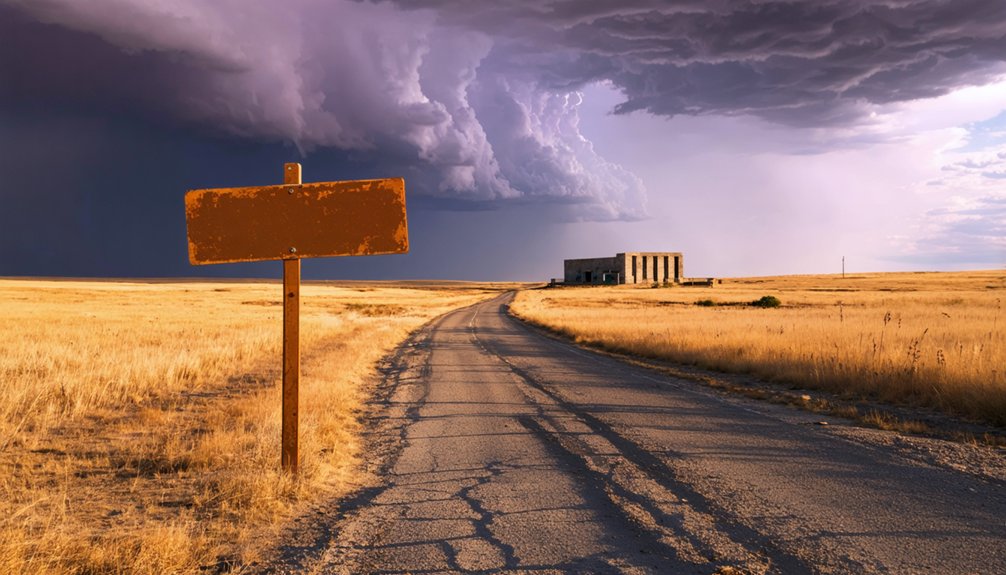
To reach it, you’ll want to map your travel routes through Edgemont first, then head south. The site covers 33 square miles of rolling, sloping plains, so you’ll have plenty of ground to explore once you arrive.
Year-round access makes scheduling flexible, and the terrain rates as easy difficulty. Budget one to two hours to drive through the complex, taking in the bunkers and fox-holes at your own pace — no guided tours, no restrictions, just open road and raw history.
The Bunkers, Fox-Holes, and Ghost Town Streets Still Standing at Igloo
Once you pull off the road and into the complex, the scale of what you’re looking at hits fast. The bunker architecture alone is worth the drive — 801 earth-covered concrete mounds stretching across 33 square miles, each sealed with heavy steel doors that’ve held their ground for decades.
Here’s what you’ll encounter exploring the site:
- Bunkers maintaining steady interior temperatures year-round thanks to thick sod coverings
- Fox-holes — concrete shelters scattered strategically between the bunkers
- Community remnants — intact streets mapping out where over 1,000 people once lived, worked, and built real lives
You’re walking through a fully functioning town frozen in time. The roads still run straight. The layout still makes sense. Only the people are gone.
What Happened When Preppers Took Over the Bunkers?
Vivos xPoint moved in around 2016, marketing the bunkers as the world’s largest survival community — a self-sustainable refuge for preppers and survivalists looking to ride out societal collapse in style.
Over 200 bunkers were leased to individuals drawn to the bunker lifestyle, enthusiastic to put their survival strategies into practice far from government oversight and urban chaos.
Over 200 bunkers leased to survivalists eager to escape government oversight and build life on their own terms.
But reality hit hard. Residents reported unfulfilled promises on amenities, security failures, and safety complaints. Lawsuits and evictions followed, and an FBI inquiry raised eyebrows.
Despite the turbulence, many residents still carry handguns and maintain their ground, committed to building something independent on their own terms.
It’s a messy, unpolished experiment in freedom — exactly the kind of raw, unfiltered living that draws certain people to places like Igloo.
Is It Safe To Visit Igloo Today?
Visiting Igloo today is straightforward, but it’s worth knowing what you’re walking into. The site isn’t government-controlled, and Vivos xPoint residents carry handguns openly. Visitor experiences vary, so approach with awareness and respect the private community boundaries.
Key safety precautions to keep in mind:
- Stay on accessible roads — bunkers are scattered across 33 square miles, and some areas are privately leased.
- Expect armed residents — preppers living on-site value their privacy and security.
- Watch for hazards — decades of abandonment mean uneven terrain and deteriorating structures.
You’re free to drive through, photograph bunkers, and explore remnants of this remarkable Cold War ghost town.
Plan for one to two hours, go during daylight, and bring your own supplies.
How Long Should You Spend at Igloo?
You’ll want to set aside one to two hours to drive through the complex, take in the rows of earth-covered bunkers, and explore the remnants of what was once a thriving community.
Prioritize the igloo-shaped bunkers with their original steel doors, the fox-hole shelters scattered among them, and the ghostly street grid that hints at the town’s former life.
Igloo is accessible year-round, but visiting in late spring or early fall gives you the most comfortable weather for stepping out of your vehicle to get a closer look.
Recommended Visit Duration
Though Igloo doesn’t demand a full day, you’ll want to budget at least one to two hours to take in the eerie expanse of bunkers, crumbling streets, and fox-holes that stretch across the site’s 33 square miles.
These visit duration travel tips help you make the most of your time:
- Drive the full complex to grasp the sheer scale of 801 earth-covered bunkers standing in silent rows.
- Step out at fox-holes to examine the concrete shelters up close and photograph the steel-doored entrances.
- Arrive with daylight to spare, since the remote location offers no lighting once the sun drops.
You’re free to explore at your own pace — no gates, no ticket booths, no guided tours required.
Key Stops To Prioritize
Igloo rewards those who wander deliberately rather than rush.
Focus first on the bunker fields, where 801 earth-covered concrete structures stretch across the plains in striking formation. Their steel doors and sod-blanketed roofs tell the story of wartime urgency and Cold War anxiety better than any museum exhibit could.
Next, explore the fox-holes scattered among the abandoned structures, concrete reminders of the security measures once deemed essential here.
Walk the old street grid where a hospital, theater, and bowling alley once served thousands.
Finally, pause at the historical significance embedded in the landscape itself — mustard gas, sarin, and conventional explosives once rested beneath this quiet terrain.
Let that weight settle before you drive out. You’ll leave understanding exactly why Igloo endures in memory.
Best Time To Visit
The site’s open plains mean weather directly impacts your experience:
- Spring and fall offer mild temperatures, soft light, and fewer crowds — ideal for absorbing the historical significance without battling heat or ice.
- Summer delivers long daylight hours, giving you maximum time to drive through the bunker complex and photograph fox-holes.
- Winter creates an eerie, isolated atmosphere that amplifies the ghost town’s haunting character, though roads can be unpredictable.
Plan for one to two hours on-site.
You’re driving through open terrain, not touring a museum, so you move at your own pace — freely, deliberately, on your terms.
When Is the Best Time of Year To Visit Igloo?
When should you plan your visit to Igloo, South Dakota? Late spring through early fall offers the most comfortable conditions for exploring this remote ghost town.
Summer months deliver warm, dry weather that’s ideal for driving through the complex and examining the bunkers up close. Keep weather considerations in mind, though — South Dakota summers can bring intense heat and sudden thunderstorms, so pack accordingly.
Summer brings warm, dry days perfect for exploring Igloo’s bunkers — but pack for heat and sudden storms.
Fall rewards visitors with cooler temperatures and stunning prairie landscapes, making it perfect for photography and extended exploration.
If you’re drawn to seasonal activities, winter visits are possible but challenging, as snow and icy roads can make navigation difficult across the site’s 33 square miles.
Whatever season you choose, this abandoned Cold War relic delivers a haunting, unforgettable experience year-round.
How To Combine Igloo With a Black Hills Day Trip
Igloo sits just eight miles south of Edgemont, putting you within easy striking distance of the Black Hills’ most iconic stops, including Mount Rushmore, Crazy Horse Memorial, and Custer State Park.
You can structure your day trip by heading north through Edgemont toward Wind Cave National Park, then looping through Custer and Hill City before catching Igloo on your return south.
This route lets you mix the region’s natural wonders and historical landmarks with Igloo’s eerie, bunker-dotted landscape for a well-rounded and unforgettable day.
Black Hills Nearby Attractions
Since Igloo sits just eight miles south of Edgemont in southwestern South Dakota, it’s perfectly positioned as a starting point for a broader Black Hills day trip.
After exploring the bunkers, head north and discover what this rugged region offers:
- Wind Cave National Park – Encounter thriving Black Hills Wildlife, including bison, elk, and pronghorn roaming freely across open prairies.
- Needles Highway – One of South Dakota’s most breathtaking Scenic Drives, weaving through towering granite spires and dense pine forests.
- Custer State Park – A vast wilderness offering wildlife loops, hiking trails, and sweeping landscapes that reward independent explorers.
You’ll cover significant ground without backtracking, making this entire corridor an efficient, rewarding route through some of America’s most untamed countryside.
Suggested Day Trip Routes
Knowing which nearby attractions to visit is only half the battle — stringing them together into a seamless route makes all the difference.
Start your morning in Custer State Park, where scenic viewpoints and local wildlife greet you early before crowds arrive. Head west through Wind Cave National Park, then push south toward Edgemont by midday.
From there, it’s just eight miles to Igloo, where you’ll spend an hour or two exploring bunkers and fox-holes before the afternoon light fades.
On your return, swing through Hot Springs for a meal and a quick stop at Mammoth Site.
This loop keeps driving efficient, rewards you with diverse landscapes, and lets you experience both natural wonder and Cold War-era history in a single, uninterrupted day.
Best Stops Along The Way
Pairing Igloo with the broader Black Hills means you can turn a quirky detour into a full day of layered history and striking scenery.
Start in Edgemont, just eight miles north, then head south for ghost town exploration and bunker exploration among Igloo’s earth-covered concrete vaults.
Round out your route with these standout stops:
- Wind Cave National Park – Explore one of the world’s longest cave systems, just an hour northeast.
- Custer State Park – Drive the Wildlife Loop Road for bison sightings and open prairie freedom.
- Hot Springs Mammoth Site – Walk an active paleontological dig preserving real mammoth bones.
Each stop adds a distinct chapter to your day, making the drive feel purposeful rather than merely passing through.
What To Pack for a Visit to an Abandoned Munitions Depot
Packing a few key items will make your visit to Igloo’s abandoned munitions depot safer and more enjoyable. Your packing essentials should include sturdy footwear, water, snacks, and a fully charged phone for navigation across the remote 33-square-mile site.
Sun protection is non-negotiable on South Dakota’s open plains.
Safety gear matters here. The site’s history with mustard gas and sarin means you’ll want to stay on established paths and avoid entering deteriorating structures.
Bring a flashlight if you’re exploring bunker exteriors after dusk. Since residents openly carry handguns and the community operates outside typical oversight, situational awareness is your best tool.
A paper map serves as reliable backup when cell service gets unpredictable this far into Fall River County’s isolated terrain.
Frequently Asked Questions
Are There Any Guided Tours Available at Igloo, South Dakota?
There aren’t formal guided tours, but you can drive through independently, embracing guided exploration at your own pace. Igloo’s historical significance unfolds as you discover abandoned bunkers and remnants of this fascinating WWII munitions community yourself.
Can You Legally Enter or Explore the Bunkers at Igloo?
You can’t freely explore Igloo’s bunkers since Vivos xPoint now controls them privately. Respecting both bunker safety and historical significance, you’ll need permission before entering these remarkable, earth-covered structures that once safeguarded America’s most critical wartime munitions.
Is There Cell Phone Service or Wi-Fi Available at Igloo?
Like a ghost itself, cell coverage and internet access are virtually nonexistent at Igloo. You’re truly off the grid here, embracing raw freedom in this remote South Dakota wilderness where modern connectivity simply can’t reach you.
Are Pets Allowed When Visiting the Igloo Bunker Complex?
The available information doesn’t specify pet policies or visitor guidelines for Igloo’s bunker complex. You’ll want to contact Vivos xPoint directly before your visit to confirm you’re following current rules for bringing your furry companions along.
Is There an Admission Fee or Permit Required to Visit Igloo?
“The best things in life are free!” You don’t need an admission fee or permit to explore Igloo’s historical significance. Simply drive through, discover local attractions like bunkers and fox-holes, and embrace your freedom to roam!
References
- https://ghost-towns.close-to-me.com/states/south-dakota/igloo-sd/
- https://www.coldwartourist.com/black-hills-ordnance-depot
- https://www.sdnewswatch.org/igloo-south-dakota-prepper-bunker-vivos-xpoint
- https://virtualglobetrotting.com/map/igloo-south-dakota/
- https://en.wikipedia.org/wiki/Black_Hills_Ordnance_Depot


