Planning a ghost town road trip to Joe’s Pond starts in Barre, winding north on Route 14 through Plainfield and into the quiet hill towns near Danville. You’ll find Joe’s Pond sitting at 1,551 feet, offering swimming, boating, and a carriage road leading to an abandoned settlement with 62+ headstones. The area’s Revolutionary War history ties back to Indian Joe himself. Stick around, and Vermont’s buried past reveals far more than you’d expect.
Key Takeaways
- Start your road trip in Barre, heading north on Route 14 through Plainfield toward West Danville, where roads transition to rugged dirt paths.
- Joe’s Pond sits at 1,551 feet elevation, offering swimming, boating, and fishing as a base between ghost town explorations.
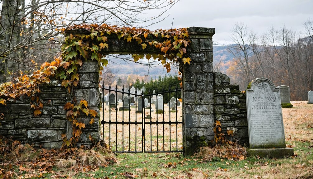
- The ghost town features scattered farm ruins and an abandoned graveyard with 62+ headstones, accessible via a carriage road off Main Street.
- Reaching the cemetery requires a rugged rock scramble; wear grippy shoes and bring trekking poles for safe navigation.
- Stay at Injun Joe Court, a rustic cabin and RV park named after Revolutionary War scout Indian Joe, near historic Bailey-Hazen Road.
How to Get Here: The Best Route Through Barre, Plainfield, and Danville
Starting your journey in Barre, head north on Route 14 through Plainfield, where the road winds past brooks and springs before climbing into the quieter hill towns.
You’ll pass through landscapes largely unchanged since settlers first carved out lives here in the early 1800s — a reminder of the region’s deep historical significance.
Continue northeast toward Danville, keeping an eye out for West Danville, where Joe’s Pond sits at 1,551 feet elevation.
For exploration tips, note that several roads along this route shift from maintained surfaces to rugged dirt paths. When pavement gives way to gravel, consider parking and hiking instead.
The freedom of this backcountry drive rewards those willing to move at their own pace.
Who Was Indian Joe and Why Does He Matter Here?
Before you reach Joe’s Pond, you’ll likely wonder how it got its name — and the answer connects this quiet Vermont lake to one of the region’s most remarkable figures.
Indian Joe, a St. Francis Indian of the Coosuck tribe, hunted and fished these waters for years, spending summers here with his companion Molly. His cultural significance extends far beyond the shoreline — he served as a scout and guide for Generals Jacob Bayley and John Hazen during the 1775-1776 Canadian campaign.
Vermont’s Legislature recognized Indian Joe‘s legacy by awarding him a pension for his military contributions. When you explore this area, you’re traveling through land shaped by his presence, and that history deserves more than a passing glance.
What Makes Joe’s Pond a Perfect Ghost Town Base Camp?
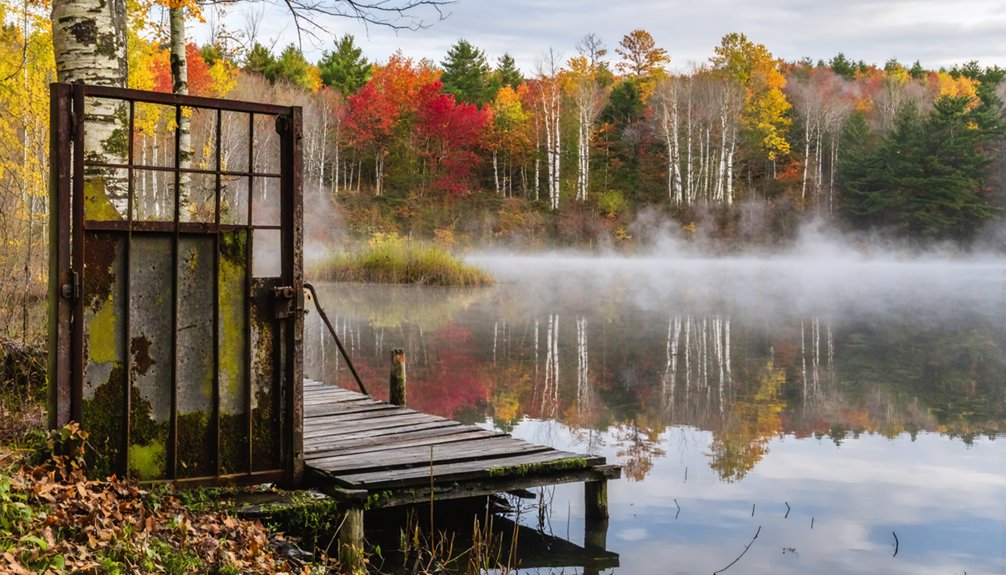
When you’re ready to explore the ghost town ruins two miles above Starksboro, Joe’s Pond gives you an ideal staging ground at 1,551 feet elevation, covering 393 scenic acres with crystal-clear waters perfect for swimming, boating, and fishing between your mountain excursions.
You’ll find the abandoned settlement accessible via carriage road from Main Street, putting history within easy striking distance of your base camp.
The surrounding landscape of brooks, springs, and nearby ponds like Cole’s and Lyford’s in Walden rounds out the experience, ensuring you’ve got plenty to do when you’re not scrambling over farm ruins and cemetery grounds.
Scenic Base Camp Location
Nestled at 1,551 feet elevation, Joe’s Pond stretches three miles long and spans nearly three-quarters of a mile wide, covering roughly 393 acres of clear, swimmable water — and it’s exactly the kind of scenic retreat that makes a ghost town road trip feel less like roughing it and more like an adventure with a comfortable home base.
You’ll find scenic viewpoints around every bend, whether you’re out on the water or exploring the surrounding hills. Wildlife encounters are practically guaranteed, giving you that raw, untamed Vermont experience between your historical explorations.
At roughly 100 feet deep, the pond supports boating and fishing, so your downtime stays as active as your adventures. It’s your launchpad — invigorating, beautiful, and perfectly positioned for everything the region offers.
Nearby Ghost Town Access
Just two miles above Starksboro, a forgotten mountain community waits — and Joe’s Pond puts you close enough to reach it without sacrificing comfort. This abandoned settlement dates to the early 1800s, when over 62 residents carved lives from these Vermont hills before eventually disappearing into ghost town legends.
You’ll access the site via a carriage road off Main Street, following an unmaintained dirt path that eventually evolves into a rock scramble.
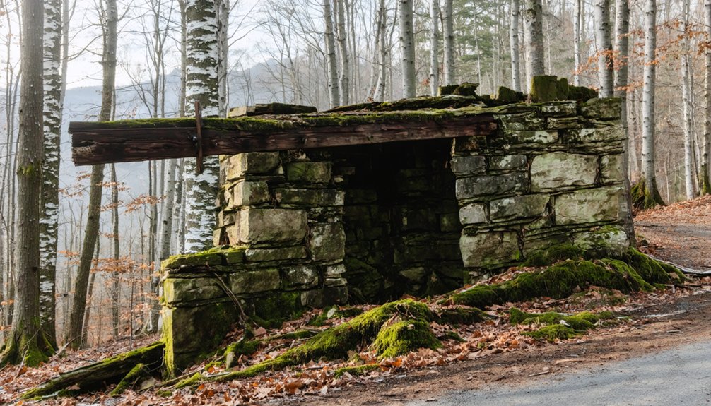
Farm ruins and an abandoned cemetery still mark the landscape, frozen in time and worthy of historical preservation efforts now protecting the area as a nature preserve.
When the road becomes too rough for your vehicle, simply park and hike in. The terrain rewards the curious traveler willing to push a little further into Vermont’s forgotten past.
Outdoor Recreation Opportunities
Between ghost town hikes, Joe’s Pond delivers 393 acres of clear water and three miles of shoreline to reset your legs and recharge your spirit.
You’ll find the pond stretches three-quarters of a mile wide and plunges 100 feet deep, making it ideal for swimming, boating, and fishing.
Nature exploration here isn’t limited to abandoned ruins and overgrown cemeteries. The surrounding brooks and springs invite you to slow down and breathe.
Nearby Cole’s Pond and Lyford’s Pond in Walden expand your outdoor activities beyond a single destination.
Whether you’re casting a line at dawn or paddling across glassy water at dusk, Joe’s Pond rewards explorers who move freely between wilderness adventure and quiet waterfront recovery.
This region doesn’t fence you in.
The Forgotten Village Hidden Two Miles Above Starksboro
Two miles above Starksboro, hidden deep in the mountains, lies a ghost village that most Vermonters have never heard of. Dating back to the early 1800s, this forgotten farming community once housed over 62 residents before time swallowed it whole.
Today, you’ll find scattered farm ruins, an abandoned graveyard, and the quiet weight of village legends few people ever chase down.
Scattered ruins, an abandoned graveyard, and village legends few people ever think to chase down.
You can reach the site via a carriage road off Main Street, though the path eventually shifts from dirt to rock scramble terrain. When driving becomes unsafe, lace up your boots and hike in.
The cemetery even appears on Google Maps, making navigation straightforward. Forgotten histories don’t always stay buried — sometimes they’re just waiting for someone curious enough to find them.
How to Drive the Carriage Road Into the Mountains
You’ll find the carriage road’s starting point right off Main Street, where it winds up into the hills toward the abandoned settlement.
The road begins as an unmaintained dirt track, but as you climb higher, it shifts into rocky terrain that’ll challenge even a capable vehicle.
When the path becomes too rough to drive safely, park and continue on foot — the hike rewards you with scattered farm ruins and an old cemetery waiting quietly among the trees.
Carriage Road Starting Point
Starting from Main Street in Starksboro, the carriage road winds roughly two miles up into the mountains, leading you straight into the heart of this abandoned 19th-century settlement.
The carriage road features an unmaintained dirt surface that gradually shifts into rocky terrain, so you’ll want to park your vehicle once the path becomes too rough to navigate safely.
From there, it’s a hike on foot through land steeped in historical significance — once home to over 62 residents who farmed these hills in the early 1800s.
The surrounding brooks and springs make the approach genuinely scenic, rewarding your effort before you even reach the ruins.
Think of this road as your gateway between the modern world and a forgotten Vermont past.
When To Hike Instead
Once the carriage road shifts from packed dirt to jagged rock scramble, driving further isn’t just impractical — it’s a signal to lace up your boots and continue on foot.
Park your vehicle where the terrain changes and embrace the hike. Hiking safety here means wearing sturdy footwear and carrying water, since no maintained trail infrastructure exists beyond that point.
Seasonal considerations matter too — spring mud season makes the lower road slippery and unpredictable, while late autumn leaf cover can disguise uneven footing near the ruins.
Summer and early fall offer the most reliable conditions for reaching the abandoned cemetery and scattered farm remnants.
The scramble rewards patience, delivering you to a settlement frozen in the early 1800s, completely on your own terms.
What to Expect at the Abandoned Cemetery and Farm Ruins
As the carriage road shifts from packed dirt to a rugged rock scramble, you’ll know you’re getting close to what remains of this early 1800s farming community.
Cemetery exploration here means wandering through an unmaintained graveyard where headstones mark the lives of 62+ residents who once called these Vermont mountains home. Google Maps actually lists the cemetery, making it easier to pinpoint before you arrive.
Scattered across the surrounding landscape, farm architecture tells its own story through crumbling foundations, stone walls, and structural remnants reclaimed by decades of forest growth.
Crumbling foundations and stone walls emerge from the forest, quietly reclaiming what settlers once built.
This isn’t a manicured historic site — it’s raw, untouched history sitting quietly in a nature preserve.
Come prepared to pick your own path and discover what these mountain settlers left behind.
When the Road Ends and the Rock Scramble Begins
The carriage road doesn’t end gently — it simply stops cooperating. One moment you’re traversing rutted dirt, and the next, you’re staring down rocky terrain that demands your full attention. This is where you leave the vehicle behind and commit to the scramble.
Pick your footing carefully. The rocks shift unexpectedly, and loose gravel hides beneath leaf cover. A few solid hiking tips worth remembering: wear grippy trail shoes, bring trekking poles if balance concerns you, and never rush the ascent.
The reward justifies the effort. Beyond the scramble, the remnants of this early 1800s settlement reveal themselves quietly — stone foundations, forgotten fence lines, wilderness reclaiming what settlers once cleared.
You’re not just hiking here. You’re walking through layers of Vermont’s buried history.
What Swimmers and Boaters Need to Know About Joe’s Pond
Joe’s Pond sits at 1,551 feet of elevation, stretching three miles long and nearly three-quarters of a mile wide — and it’s exactly the kind of place that rewards anyone willing to make the drive out to Danville.
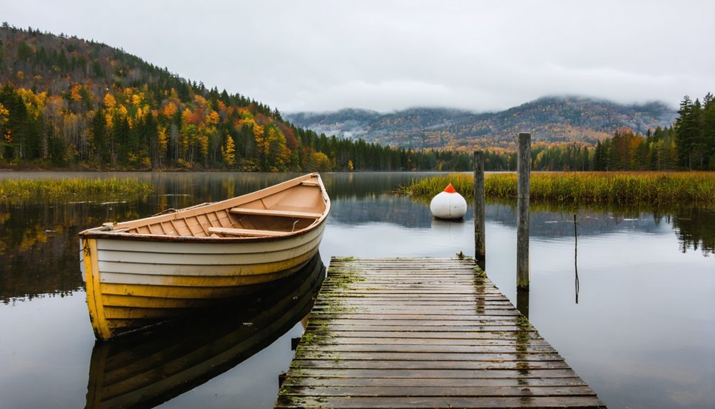
Covering roughly 393 acres with depths reaching 100 feet, the water stays clear and inviting throughout summer. You’ll find solid opportunities for swimming, boating, and fishing without the overcrowded chaos of more popular lakes.
Follow standard swimming safety practices — never swim alone, and know the depth before you dive. Boating regulations apply here, so check Vermont Fish & Wildlife guidelines before launching anything motorized.
Whether you’re paddling quietly across the surface or casting a line near the shallows, Joe’s Pond delivers a genuinely freeing outdoor experience.
Cole’s Pond, Lyford’s Pond, and Other Stops Worth Adding
While Joe’s Pond deserves its place as the main attraction, Walden’s Cole’s Pond and Lyford’s Pond are worth folding into your itinerary if you’ve got time to wander.
Both offer clear waters ideal for swimming, boating, and fishing, plus scenic views that reward anyone willing to slow down. The surrounding brooks and springs add natural character to the landscape, making the drive itself feel purposeful rather than a mere passage.
If you’re craving more solitude, look for hidden trails branching off the backroads connecting these smaller ponds. You’ll also find Route 14 through Barre to Plainfield a practical connector for stringing these stops together efficiently.
Keep your schedule loose — Vermont’s backroads have a way of revealing something worth pausing for when you least expect it.
Where to Stay: Injun Joe Court in West Danville
After a long day of exploring ghost towns and backcountry roads, you’ll want a place to rest that matches the historic spirit of your journey—and Injun Joe Court in West Danville delivers exactly that.
Named after the Revolutionary War-era scout Indian Joe, this property offers rustic tourist cabin rentals and RV park accommodations that carry a genuine sense of the past.
You’ll appreciate how the management actively works to preserve the site’s historic charm rather than trading it away for modern conveniences.
Historic Cabin Rentals Available
Nestled in West Danville, Injun Joe Court offers a collection of historic tourist cabins that carry the spirit of the Revolutionary War era straight into your vacation.
Named after Indian Joe, the St. Francis scout who guided Revolutionary generals through these very hills, the property’s historic architecture connects you directly to Vermont’s rugged past.
Here’s what you’ll find during your stay:
- Summer cabin rentals steeped in authentic New England character
- RV park hookups for travelers who prefer their own accommodations
- Historic cabin amenities balancing old-world charm with modern comfort
- Proximity to Bailey-Hazen Road, a protected landmark tied to the property’s own history
You’re not just renting a cabin — you’re sleeping inside a living piece of American history.
RV Park Accommodations
For RV travelers, Injun Joe Court delivers more than just a place to park — it drops you right into the heart of West Danville’s Revolutionary War heritage.
The property sits along the historic Bailey-Hazen Road corridor, connecting you directly to ghost town history while offering solid RV amenities for summer stays.
You’ll appreciate the rustic charm here — this isn’t a sterile corporate campground. Management intentionally preserves the property’s historic character, keeping the atmosphere genuine and grounded.
Nature engagement comes naturally when Joe’s Pond sits nearby, offering swimming, boating, and fishing just minutes from your site.
Park your rig, walk the surrounding landscape, and let the region’s layered past sink in.
Injun Joe Court earns its name by keeping history alive around every corner.
Preserving Revolutionary War Charm
Injun Joe Court doesn’t just reference Revolutionary War history — it lives inside it. Named after Indian Joe, the St. Francis scout who guided generals through Canada, this West Danville property honors authentic historic preservation without sacrificing comfort.
You’ll find yourself camping where real history unfolded.
What makes Injun Joe Court worth your stay:
- Direct connection to the Bailey-Hazen Road, a Revolutionary War military route
- Summer cabin rentals retaining original historic character
- RV hookups for travelers preferring modern flexibility
- Authentic atmosphere shaped by deliberate historic preservation efforts
Management actively maintains the property’s heritage identity rather than modernizing it away.
You’re not just renting a spot — you’re occupying a living piece of Vermont’s Revolutionary War legacy.
Frequently Asked Questions
Are Pets Allowed on the Carriage Road Trail to the Ghost Village?
The knowledge doesn’t specify pet-friendly policies for the carriage road trail. You’ll want to check with local authorities before heading out. Practicing good trail etiquette means always being prepared with leash rules and cleanup essentials.
What Is the Best Time of Year to Visit Joe’s Pond?
Summer’s your best bet for Joe’s Pond! You’ll enjoy ideal weather considerations for swimming, boating, and fishing across its 393 acres. Spring and fall offer stunning seasonal activities, but winter’s cold limits your freedom to fully explore.
Is There a Fee to Access the Nature Preserve Near Starksboro?
The knowledge doesn’t specify any fees for Starksboro access, but you’ll want to check current nature preserve rules before heading out — regulations can change, and it’s always smart to confirm before you explore!
Are Campfires Permitted Anywhere Along the Hiking Trails?
The provided knowledge doesn’t specify campfire regulations for these trails. You’ll want to check with local authorities before lighting any flames—fire safety’s essential, so don’t assume campfires are permitted without confirming current rules first!
What Wildlife Might Visitors Encounter Throughout the Surrounding Mountain Areas?
Ironically, you’ll share these mountain trails with locals who never pay admission! Expect wildlife sightings of deer, black bears, and foxes, where animal behavior ranges from shy retreats to curious glances as you explore freely.
References
- https://www.instagram.com/reel/DBqvoTHO7Ck/
- https://www.joespondvermont.com/a-history-of-joes-pond.html
- https://www.vermonter.com/beautiful-danville-vermont/
- https://www.youtube.com/watch?v=ScW-H7A8yL8
- https://preservationinpink.wordpress.com/2018/06/13/tourist-cabins-injunjoe-court-west-danville-vt/
- https://www.northstarmonthly.com/features/joes-pond-islands-indian-joes-refuge-and-historical-tale/article_7b6a2e6a-8541-57cc-8aec-168785d063bf.html
- https://www.facebook.com/groups/739731312877597/posts/1199924466858277/
- https://www.youtube.com/watch?v=9jxivOfRH7I
- https://www.reddit.com/r/vermont/comments/16a2v37/most_unsettling_places_in_vermont/
- https://jpacurrentnews.blogspot.com/2024/11/road-trips-weather.html


