
You’ll find Juno in north central Val Verde County, accessible via State Highway 163 and Farm Road 189. This sun-scorched ghost town earned its quirky name from café owner Henry Stein’s accent—when asked about his menu, he’d reply “Ju know.” Once a thriving ranching supply center with 80 residents, Juno declined after a devastating 1954 flood and the 1975 post office closure. Today, it’s privately owned land with fascinating historical markers dotting the surrounding highway, revealing stories of frontier battles and stagecoach routes.
Key Takeaways
- Access Juno via State Highway 163 and Farm Road 189 in north central Val Verde County using GPS coordinates and geological survey maps.
- Visit historical markers along Highway 163, including Comstock Stage Stand, Hood’s Devil River Fight, and Camp Hudson commemorative sites.
- Explore nearby Seminole Canyon State Historical Park to view prehistoric rock art and experience the region’s natural Devils River landscape.
- Juno is on private land; the last business closed in 1984, so respect property boundaries when viewing the ghost town.
- Peak population reached 80 in the 1960s before decline; the post office operated from 1885 to 1975 during ranching prosperity.
Getting to Juno: Directions and Highway Access
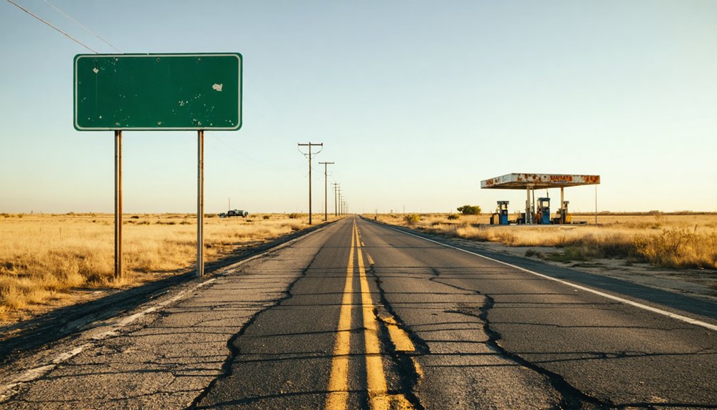
Tucked into the sun-scorched rangeland of north central Val Verde County, Juno beckons ghost town enthusiasts willing to venture deep into West Texas’s unforgiving terrain. You’ll find this vanished settlement at coordinates 30.151944, -101.115278, accessible via State Highway 163 and Farm Road 189. These ribbons of asphalt cut through rugged landscape where civilization surrendered to harsh reality decades ago.
Your journey follows regional drives that reveal West Texas’s raw character—mesquite-dotted flats stretching toward distant mesas, with the Devils River carving its ancient path nearby. Located half a mile southwest of Cully Draw, Juno’s remains blend into terrain features that tell stories of ambition and abandonment. Navigate using the Juno U.S. Geological Survey Map, letting GPS coordinates guide you where signposts have long since disappeared into dust.
The Fascinating Story Behind the Town’s Unusual Name
Long before you arrive at those GPS coordinates, you’ll wonder how this windswept outpost earned a name that sounds like a Roman goddess wandered into West Texas. The truth’s far better: Henry Stein’s colorful character shaped everything.
Operating a bare-bones café in the 1880s, Stein served only beans and beer. When travelers asked about other menu options, he’d answer with his thick accent: “Ju know.” That simple phrase captured Juno’s early pioneer spirit perfectly—practical, humorous, stripped of pretense.
When residents applied for a post office in 1885, they added “Juno” to the application, cementing the café legend into official records. The name stuck until the post office closed in 1975, proof that frontier humor outlasts empires. No goddess here—just one man’s accent creating identity from nothing.
From Frontier Outpost to Ranching Supply Center
As you trace Juno’s evolution, you’ll discover its transformation began in 1849, when troops arrived at Beaver Lake to guard the San Antonio-El Paso stage line from Comanche and Apache raids. The soldiers camped beneath steep canyon walls along Devil’s River, drawn to the same cool waters and natural shade that Native Americans had enjoyed for centuries before them.
Military Protection at Beaver Lake
On July 20, 1857, Lt. John Bell Hood’s Company G faced a brutal ambush just two miles from Beaver Lake. Outnumbered against 100 Comanche and Lipan Apache warriors, his cavalrymen fought through brush fires while two soldiers fell.
The skirmish marked the shift from open frontier to military-protected territory, transforming this once-contested ground into secure ranching infrastructure.
Henry Stein’s Famous Café
When travelers asked about the menu at Henry Stein’s café in 1880s Juno, they received the same terse reply every time: “Ju know.” The German immigrant’s thick accent transformed this dismissive phrase into the town’s eventual namesake, but his establishment offered nothing more elaborate than its linguistic legacy—just frijoles and beer, day after day.
This frontier culinary simplicity wasn’t laziness—it was survival economics in a ranching outpost where supply wagons arrived sporadically. Stein’s legendary menu response became shorthand for the no-frills existence you’d find throughout West Texas, where pretension died alongside weaker enterprises. His café anchored Juno’s brief prominence as a supply center, serving cowboys and stage passengers who didn’t expect white tablecloths.
Eventually, Stein faced bankruptcy in Forty-fifth District court, another casualty of boom-and-bust frontier commerce.
1880s Ranching Supply Hub
By the 1880s, Juno had shed its rough frontier origins to become the county’s second oldest settlement and a specialized nerve center for West Texas ranching operations. You’ll discover how its natural lake and strategic positioning along cattle drive route connectivity transformed this outpost into something far more valuable—a consolidated supply depot serving sprawling ranching empires across the region.
Local merchants secured lucrative supply contracts, providing everything from saddles and barbed wire to provisions and livestock equipment. The town’s prosperity hinged entirely on the ranching sector’s health, with traders capitalizing on constant demand from cattle operations. That natural landmark made coordination simple, drawing business consolidation that created sustained commercial activity.
Juno’s economic model worked brilliantly—until shifting ranching patterns eventually rendered the specialized hub obsolete, leaving behind the ghost town you’ll explore today.
Notable Landmarks Along Highway 163
Highway 163 threads through some of Texas’s most historically significant and geologically dramatic terrain, where weathered markers and natural landmarks chronicle centuries of frontier life. You’ll encounter the Comstock Stage Stand marker 19 miles south of Ozona, commemorating essential stagecoach stops that connected isolated settlements.
Further south, Hood’s Devil River Fight marker recalls a Civil War skirmish near Pecos Crossing, while the Camp Hudson marker stands 20.3 miles north of U.S. 90, marking one of Texas’s indispensable frontier army posts from 1861.
The Devils River itself flows alongside the highway south of Juno, cutting through ranch country with untamed beauty. East of the route, Seminole Canyon State Historical Park preserves prehistoric rock art, offering hiking trails that lead you through thousands of years of human history.
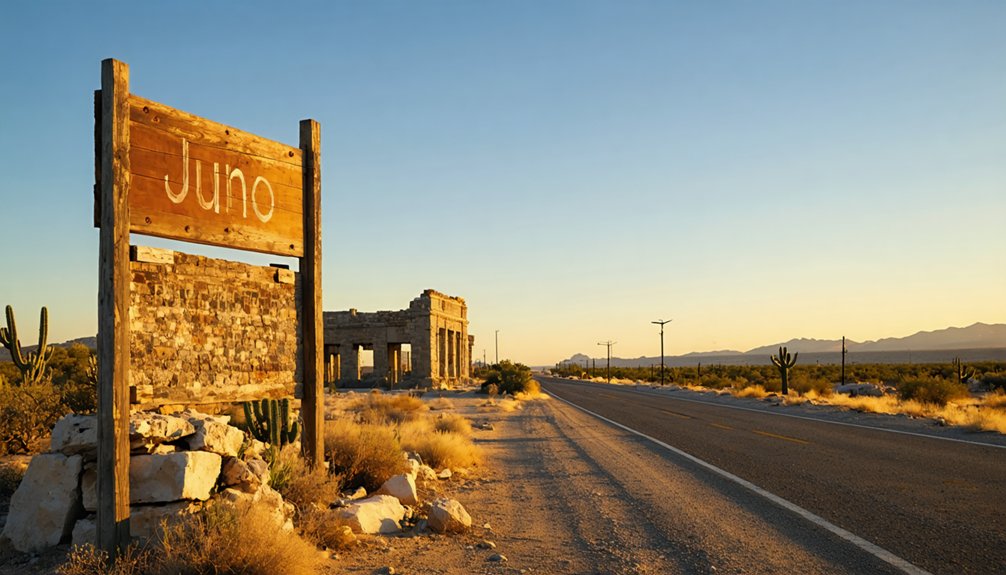
What Remains of Juno Today
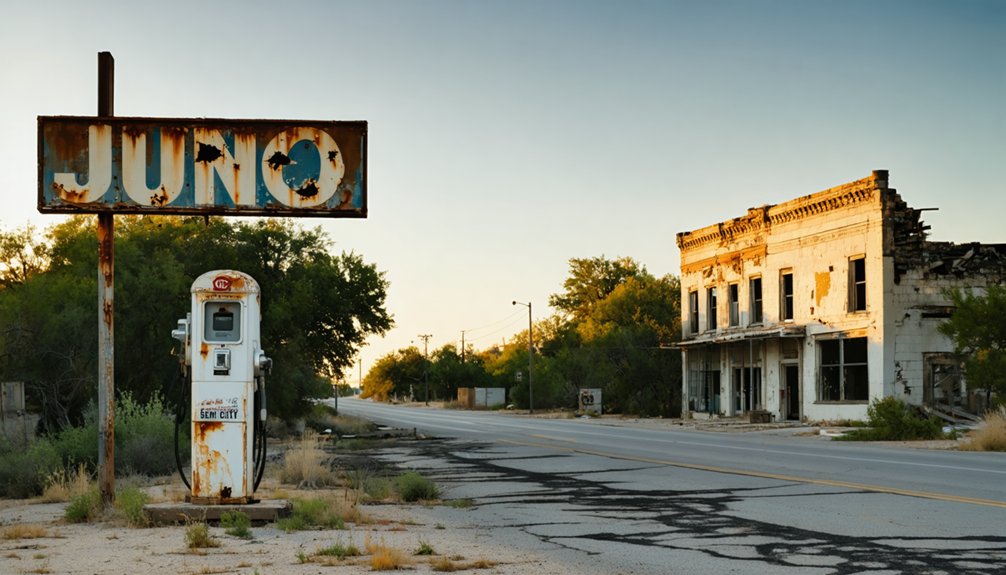
The ghost town of Juno sits at coordinates 30°09′07″N 101°06′55″W, 48 miles north-northwest of Del Rio in Val Verde County’s remote ranch country. By 2013, only a lone ranch operations remained on what’s now private land, marking the final chapter of a settlement that shuttered its last business in 1984.
You’ll find wide streets and former building sites scattered across the property, though nothing remains of the general store, café, school, or land office that once served residents. The remnant structures and land sites rest three miles from Devil’s River’s steep canyon walls near Beaver Lake. Access requires permission from landowners who maintain this isolated corner of Texas, where a population that peaked at 80 dwindled to near-total abandonment.
Understanding Juno’s Decline: From 1960s to Ghost Town Status
The vibrant ranching hub that sustained 75 residents for four decades crumbled with startling speed—from 80 people in 1964 to just 10 by 1968. This collapse wasn’t triggered by a single catastrophe but by a perfect storm of forces: the devastating 1954 flood that preceded the decline, the post office’s 1975 closure that severed Juno’s administrative lifeline, and the relentless pull of progress that drained rural Texas towns throughout the 1960s.
You’ll find that understanding Juno’s transformation into a ghost town requires examining how these converging pressures dismantled a community that had endured since the 1880s.
Population Collapse 1964-1968
Between 1964 and 1968, Juno experienced a demographic shift that transformed it from a struggling settlement into an abandoned outpost, though the precise population figures from this critical period remain lost to incomplete record-keeping.
What you’ll discover when researching this remote Val Verde County location is frustrating gaps in documented history. The reasons for population decline likely mirrored broader rural Texas patterns—young people abandoning isolated communities for urban opportunities.
Farming challenges in the region, including unpredictable rainfall and harsh terrain, made sustaining livelihoods increasingly difficult. Without concrete census data or local newspapers from these pivotal years, you’re left piecing together Juno’s story from fragments. To uncover authentic details about this ghost town’s collapse, you’ll need to dig into county archives and historical commission records yourself.
Post Office Closure Impact
While scattered population losses marked Juno’s initial decline, its 1975 post office closure delivered a fatal blow to the struggling settlement. You’ll find this marked the severance of the town’s crucial mail and communication lifeline, creating irreversible isolation for remaining residents. The closure preceded the final business shutdown by nine years, accelerating Juno’s transformation into a ghost town.
Without postal service, diminished communication channels left the ranching community disconnected from essential supply networks and social ties. The single business that’d operated since 1931 couldn’t sustain itself in this isolated environment, finally shuttering in 1984. By then, the population had plummeted to just ten souls. Today, you’ll discover only a lone ranch where a once-thriving supply center served seventy-five residents and bustling ranching operations.
1954 Flood Devastation
Catastrophic flooding struck Central Texas on July 4, 2025, when stalled thunderstorms discharged four months’ worth of rain in mere hours across the Hill Country. The Guadalupe River surged 26 feet in just 45 minutes, cresting at a record 37.52 feet near Hunt.
Flash flood emergencies ravaged Kerr County starting at 4:03 a.m., with volunteer rescue coordination mobilizing immediately as buildings collapsed along the river. By July 8, the death toll reached 111, with over 172 people missing and 440 rescued.
Aid poured in from Louisiana, Colorado, Ohio, Minnesota, Mexico, and NASA as flood shelter logistics strained under demand. This disaster forever altered the region’s landscape, leaving communities like nearby Juno even more isolated and abandoned.
The Lost Natural Wonder: Beaver Lake’s Disappearance

Yet this natural wonder has vanished from modern records, leaving only folklore and faded historical accounts.
The lake that once anchored Juno’s survival now exists solely in ghost town lore—a phantom landscape as elusive as the wolf-raised child rumored born on its banks, disappearing alongside the community it sustained.
Important Access Restrictions and Private Property Boundaries
Nearly every acre of Texas—97% of the state—belongs to private landowners who guard their property with fierce determination. When you venture to Juno, understand that stepping off Ranch Road 189 transforms you from explorer to trespasser instantly. The few remaining structures from this 1880s settlement stand entirely on private ranches, making prohibited entry a serious legal matter rather than a casual transgression.
The ghost town exists only as roadside glimpses during your drive along Ranch Road 189 near Devil’s River. No buildings welcome visitors, no paths invite exploration. Your freedom here means respecting boundaries—staying on public roadways while this haunting landscape unfolds through your windshield, untouchable yet unforgettable.
as the journey continues, one might find themselves imagining ghost towns near Dodge City, where remnants of the past cling to the windswept plains. Each abandoned structure tells a story of dreams once bright, now faded into the horizon, invoking a sense of nostalgia and curiosity. These desolate places invite the adventurous spirit to uncover their secrets, even as they remain shrouded in mystery.
You’ll find aggressive landowner responses common throughout this remote terrain, where ranchers protect their acreage zealously.
Best Time to Visit and What to Bring
The ghost town of Juno reveals its starkest beauty between December and February, when cold, crystalline skies transform the Devil’s River country into a photographer’s dream. You’ll find exceptional stargazing opportunities and wildlife observation experiences during these winter months, with minimal crowds disrupting your exploration. Mid-week visits in early December or late February offer maximum solitude.
Essential gear for your Juno expedition:
- Sun protection and hydration: Hat, sunscreen, and ample water for desert conditions
- Navigation tools: Physical maps and offline GPS for this remote territory
- Sturdy footwear: Hiking boots for traversing crumbling structures and uneven terrain
- Emergency supplies: Full fuel tank, first aid kit, and charged communication devices
Avoid March through April’s wildflower crowds and September’s flooding rains that historically rendered crossings impassable.
Nearby Attractions on the Law West of the Pecos Loop
After leaving Juno’s windswept ruins, your journey naturally leads thirty miles southeast to Langtry, where Judge Roy Bean’s legendary saloon still stands as a monument to frontier justice at its most eccentric. The free visitor center preserves the very courtroom where Bean dispensed his peculiar brand of law, fining corpses and obsessing over actress Lillie Langtry from his remote desert outpost.
You’ll wander through desert garden blooms showcasing native cacti in spring and summer, then explore curated exhibitions detailing the railroad town’s wild origins. Regional trail connections along the Texas Pecos Trail open routes toward Big Bend National Park and the Davis Mountains, while White Shaman Cave beckons six miles away. This Highway 90 rest stop breaks your drive between Del Rio and Sanderson, offering rare amenities in remarkably isolated territory.
Frequently Asked Questions
Are There Any Restaurants or Gas Stations Available in Juno?
No restaurants or gas stations exist in abandoned Juno—you’ll find local food options and nearby accommodations clustering around Terlingua, over 100 miles away. Fuel up beforehand; this ghost town offers only desert solitude and freedom from civilization’s conveniences.
Can I Explore the Remaining Buildings in Juno?
You can’t explore remaining structures since the school property’s fenced and locked. You’ll need to examine town artifacts from outside the barriers. Private ownership restricts access, limiting your exploration to exterior views and publicly accessible areas only.
Is Overnight Camping Permitted Near the Juno Town Site?
Overnight camping isn’t permitted directly at Juno’s town site due to private property access restrictions and historical preservation concerns. You’ll need to camp at designated sites in nearby Black Gap WMA, where primitive facilities await your adventure.
How Long Should I Plan to Spend Visiting Juno?
You’ll need just 30-45 minutes to absorb Juno’s historical significance—unless local legends surrounding Juno captivate you longer. There’s minimal to see beyond ruins and fencing, so don’t expect a day-long adventure in this deserted outpost.
Are Guided Tours of Juno Ghost Town Available?
No guided tours or private tours operate at Juno Ghost Town. You’ll explore independently along the roadway, respecting private property boundaries. This self-guided tour offers authentic freedom to discover remaining ruins at your own pace in remote Texas backcountry.


