To plan your ghost town road trip to Monarch, Colorado, head east from Gunnison on Highway 50, then turn onto County Road 888 toward Whitepine. You’ll need a high-clearance 4WD vehicle to navigate rough shelf roads near 10,000 feet. Pack layers, recovery gear, and a paper map — cell service won’t save you out here. St. Elmo, Hancock, and Tin Cup all reward the prepared traveler, and there’s far more to discover along this storied corridor.
Key Takeaways
- From Gunnison, travel east on Highway 50 for 33 miles, then turn onto County Road 888 to access Whitepine and surrounding ghost towns.
- A high-clearance 4WD vehicle is essential for navigating rough shelf roads, and recovery gear and a spare tire are strongly recommended.
- St. Elmo, Tin Cup, Hancock, and Gothic are among Colorado’s most intact ghost towns near the Monarch Pass corridor worth exploring.
- Weather above 10,000 feet changes rapidly, with temperature swings from 30s to 70s°F and possible snow even in July.
- Pack layered clothing, navigation maps, a first-aid kit, water filtration, and camping gear suitable for remote dispersed sites.
The Mining History Behind Whitepine and the Monarch Ghost Towns
When you roll into Whitepine today, it’s hard to imagine the relentless clatter of ore carts and steam engines that once defined this place.
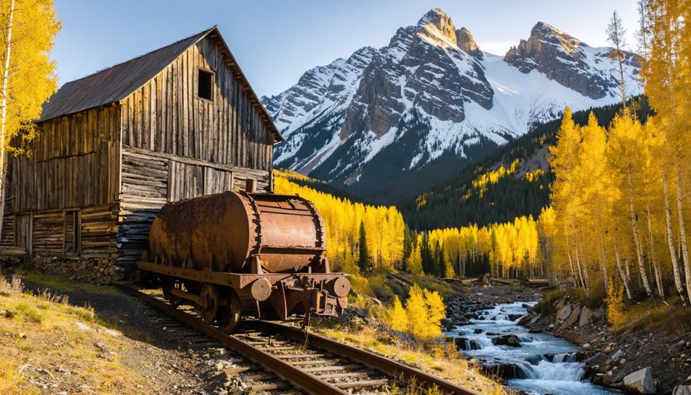
Yet this quiet valley once fueled Colorado’s gold and silver rush, supplying mines near Maysville, Garfield, and the legendary Monarch-Madonna Mine.
The railroad spur connecting these operations broke ground in 1881 and finished in 1883, hauling ore extracted through mining techniques that pushed men and machinery to their limits.
Workers blasted, tunneled, and processed raw earth until shortly after World War II, leaving behind a legacy that defines the historical significance of this entire region.
You’re not just driving through scenery here.
You’re tracing the backbone of Colorado’s frontier economy, where fortunes were won and lost beneath these rugged, glacier-carved peaks.
How To Reach Whitepine and the Monarch Pass Ghost Town Corridor
To reach Whitepine, you’ll head east from Gunnison on Highway 50 for about 33 miles.
Then turn left onto County Road 888 for 8 miles to the trailheads.
If you’re pushing deeper into the corridor toward old Monarch Pass, turn right instead onto Forest Service Road 237, a rugged shelf road that traces the same route stagecoach drivers navigated in the 1880s.
High-clearance 4WD isn’t just recommended here — on the rougher mountain approaches, it’s essential.
Primary Access Routes
There are two primary routes that’ll put you on the doorstep of Whitepine and the broader Monarch Pass ghost town corridor, each carrying its own character and challenge.
Head east from Gunnison on Highway 50, then branch onto County Road 888 or FSR 237 — both scenic routes threading past historical landmarks that shaped Colorado’s frontier identity.
- County Road 888: Drive 33 miles east, turn left, travel 8 miles to trailheads
- FSR 237 (Old Monarch Pass Road): 34 miles east, turn right for off-road adventure
- Three versions of Monarch Pass exist; you’re crossing living history
- An 1880s stone stagecoach stop still stands nearby
- High-clearance 4WD recommended for shelf roads leading to isolated sites
Choose your route deliberately — both reward the curious and the bold.
Road Conditions And Requirements
Reaching Whitepine and the Monarch Pass ghost town corridor demands respect for the terrain — these roads weren’t engineered for comfort, they were carved by miners, mule teams, and sheer necessity.
County Road 888 will test your rig over eight miles of rough, unpredictable surface where road maintenance is minimal by design, preserving the raw character of the landscape.
The shelf roads climbing toward isolated sites like Hancock and Gothic are unforgiving — you’ll need high-clearance 4WD to navigate them safely. Vehicle requirements here aren’t bureaucratic formalities; they’re survival logic.
Seasonal weather compounds every challenge, with temperatures swinging from the 30s to 70s Fahrenheit and afternoon storms materializing fast.
Come prepared, drive deliberately, and your machine will carry you where pavement surrendered long ago.
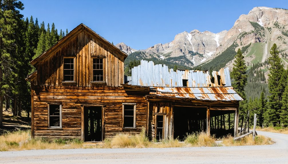
Ghost Towns Along the Monarch Pass Corridor You Can Actually Explore
Along the Monarch Pass corridor, ghost towns aren’t just relics you read about — they’re places you can actually walk through, camp near, and feel the weight of Colorado’s mining past under your boots.
Each site carries real historical significance, and ghost town exploration here rewards the curious and the bold.
These mountains don’t give up their stories easily — but they give them to those who show up.
- Whitepine – preserved mining-era structures at the base of Monarch Pass
- St. Elmo – accessible via Route 162, one of Colorado’s most intact ghost towns
- Tin Cup – connected to St. Elmo by Tin Cup Pass over the Continental Divide
- Hancock – dispersed camping available amid ruins inside San Isabel National Forest
- Gothic – reached via Gothic Road north of Crested Butte, hauntingly beautiful
Where To Camp Near Whitepine and the Monarch Ghost Towns
Exploring these ghost towns means you’re already deep in some of Colorado’s most rewarding backcountry — and when the afternoon light drops behind the peaks, you’ll want a campsite that keeps you close to the history you came to find.
Your best camping options include dispersed camping near Hancock Ghost Town at coordinates 38.64074222°N, 106.36093936°W, where San Isabel National Forest surrounds crumbling ruins on every side.
Pack in everything you need and pack it all out. Snowblind Campground serves as another solid base, putting you steps from the Canyon Creek Loop trailhead and nearby attractions like old mine shafts and scenic shelf roads.
Permits may be required depending on season, so check beforehand. Temperatures swing from the 30s to 70s°F, so layer up and stay ready.
Hiking, Biking, and Fishing Around the Monarch Ghost Town Area
Once you’ve set up camp, the land around Monarch and Whitepine practically dares you to get moving. Hiking trails, biking routes, and fishing spots weave through country shaped by glaciers, volcanoes, and miners who worked these hills until after World War II. Outdoor adventures here carry real historical weight.
The land around Monarch and Whitepine doesn’t wait for you. It moves first.
- Ride the 20-mile Canyon Creek Loop counterclockwise from Snowblind Campground; expect baby head rocks and high-altitude solitude.
- Carry your bike when trails demand it—expert terrain rewards persistence.
- Fish streams honeycombed with mining-era history.
- Explore Old Monarch Pass Road by bike or 4WD for sweeping scenic bypasses.
- Hike toward Hancock ruins through San Isabel National Forest for views that erase modern noise.
This land doesn’t pamper you. It liberates you.
Road Conditions, Weather, and What To Pack Before You Go
Before you head out to explore Monarch’s windswept ruins and rough mountain corridors, know that many access roads demand high-clearance 4WD vehicles, with shelf roads that’ll challenge even seasoned drivers.
You’ll want to dress in layers, since temperatures swing wildly between the 30s and 70s Fahrenheit, a reminder that these high-altitude passes have humbled travelers since the stagecoach days of the 1880s.
Pack in everything you’ll need — water, food, and camping essentials — because the same rugged isolation that preserved these ghost towns means there’s no corner store waiting at the trailhead.
Road Conditions and Access
Getting to Whitepine and the surrounding ghost towns means traversing three distinct road types, each demanding a different level of preparation. County Road 888 reaches most sites, but seasonal closures and road safety concerns intensify beyond the pavement.
- High-clearance 4WD handles rough shelf roads leading to isolated mining sites.
- Old Monarch Pass Road (FSR 237) offers scenic off-road alternatives to Highway 50.
- Spring runoff creates unpredictable washouts; confirm conditions before departing.
- Canyon Creek trailhead accesses backcountry routes near Snowblind Campground.
- Seasonal closures typically affect higher elevations from late autumn through early summer.
You’re not driving toward convenience—you’re driving toward history. Every rutted mile separating you from these forgotten towns is the same distance separating you from the ordinary world you’re leaving behind.
Weather and Temperature Ranges
Weather at this elevation doesn’t negotiate—temperatures swing from the low 30s to the mid-70s Fahrenheit within a single day, and the same mountain pass that welcomed you under blue skies can turn hostile by afternoon.
These aren’t gentle weather patterns. Monarch Pass sits high enough that afternoon thunderstorms roll in fast, snow can surprise you in July, and wind cuts through exposed ridgelines without warning.
Temperature fluctuations here mirror the boom-and-bust nature of the mining era itself—unpredictable, unforgiving, and humbling. The miners who worked these hills understood that the mountain sets the terms. You should too.
Check forecasts before you leave, layer your clothing strategically, and never assume morning conditions define your afternoon. Respect the elevation, and it’ll reward you with views that justify every mile.
Essential Packing Tips
Packing for Whitepine and the surrounding ghost towns means thinking like the miners did—not romantically, but practically. Temperatures swing from the 30s to 70s°F, roads turn brutal, and help stays far away. Your camping gear and essential tools aren’t optional luxuries—they’re your lifeline out here.
- High-clearance 4WD vehicle with recovery gear and spare tire
- Layered clothing for rapid temperature shifts above 10,000 feet
- Navigation tools—maps and compass, not just a phone signal
- Camping gear built for dispersed sites: pack in, pack out
- Essential tools including a first-aid kit, water filtration, and fire starter
You’re traveling through land shaped by glaciers, volcanoes, and forgotten ambition. Respect that history by arriving prepared—freedom out here belongs to the ready.
Frequently Asked Questions
Are There Guided Ghost Town Tours Available Near Monarch Pass?
The knowledge doesn’t mention guided tours near Monarch Pass. You’ll discover ghost town history independently, exploring preserved ruins at your own pace. Seek local outfitters in Gunnison or Salida — they sometimes offer adventurous guided tours through Colorado’s storied mining past.
Is Cell Phone Service Reliable Along County Road 888?
Don’t count on a single bar of cell service along County Road 888! Rural connectivity virtually vanishes in this rugged, historic wilderness. You’ll trade modern signals for raw freedom, so download your maps before you venture out.
Can Children Safely Explore the Whitepine Ghost Town Ruins?
Children can enjoy ghost town exploration at Whitepine, but child safety demands your vigilance. You’ll want to supervise kids near unstable ruins, watch terrain carefully, and embrace this historically-grounded adventure through Colorado’s untamed, living mining heritage together.
Are Pets Allowed at Dispersed Camping Sites Near Hancock?
You’ll find dispersed camping near Hancock’s storied ruins welcomes your pets! Embrace pet-friendly policies while honoring proper camping etiquette — pack out waste, keep dogs leashed, and let history’s wild spirit inspire your adventure freely.
What Photography Permits Are Required at Colorado Ghost Towns?
You don’t need permits to capture ghost town magic! Follow ghost town etiquette and these photography tips: respect ruins, pack out trash, and shoot freely. Colorado’s historically-grounded landscapes await your adventurous lens!
References
- https://gunnisoncrestedbutte.com/blog/town-profiles-whitepine/
- https://tranquiltrekker.com/central-colorado-ghost-towns-independence-pass/
- https://msrvpark.com/area-attractions/
- https://www.colorfulcolorado.com/outdoors/biking/mountain-biking/ghost-town-tour-saint-elmo-to-tin-cup/
- https://newcountry991.com/the-ultimate-ghost-town-road-trip-through-colorado/
- https://www.youtube.com/shorts/QRcQCJiACRs
- https://thedyrt.com/camping/colorado/hancock-ghost-town-dispersed
- https://www.tripadvisor.com/ShowTopic-g28927-i252-k9498486-Travel_ghost_towns_in_colorado-Colorado.html


