Planning a ghost town road trip to Mowry, Arizona means following Forest Road 214 south of Patagonia into Coronado National Forest, where Lt. Sylvester Mowry’s Civil War-era silver empire once roared with 12 blast furnaces. You’ll need a high-clearance vehicle, sturdy boots, and plenty of water. Spring offers the best trail conditions before monsoon season closes the roads. The ruins, cemetery, and slag-covered hillsides hold stories that no museum can capture — and there’s far more to uncover ahead.
Key Takeaways
- Mowry is located 14 miles south of Patagonia in Coronado National Forest; follow Forest Road 214, turning left onto FR49 at mile 12.8.
- High-clearance vehicles are required to navigate the steep dirt path leading to Mowry’s historical mining remnants.
- Pack sturdy boots, sun protection, two liters of water, and physical maps, as cell service is unavailable.
- Spring offers ideal visiting conditions with firm trails and pleasant weather, while monsoon season can render roads completely impassable.
- Nearby ghost towns Harshaw, Washington Camp, and Duquesne offer additional historical exploration opportunities to enrich your road trip.
Why Mowry Stands Out Among Arizona Ghost Towns
While many of Arizona’s ghost towns blur together as faded facades and crumbling foundations, Mowry carries a history that’s sharper, stranger, and more layered than most.
Mowry’s uniqueness isn’t accidental — it’s earned through decades of conflict, ambition, and survival.
Mowry didn’t become remarkable by accident — every scar, story, and stone was hard-won through conflict and ambition.
You’re not just walking through a forgotten mining camp. You’re stepping into a site of genuine historical significance, where Mexican miners worked silver-rich earth as early as 1857, where a controversial military officer staked his reputation on $20,000 worth of potential, and where Civil War politics ultimately silenced an entire community.
Apache raids, Confederate sympathies, government confiscation — Mowry absorbed all of it.
Most towns have one defining story. Mowry has several, each one pulling you deeper into Arizona’s complicated, unfiltered past.
The Rise and Fall of Mowry Mine
When you trace Mowry’s origins back to 1857, you’ll find Mexican miners quietly working a rich silver and lead deposit they called the Patagonia mine—years before Lt. Sylvester Mowry bought it for $22,000 and transformed it into a $1.5 million industrial operation complete with 12 blast furnaces.
The Civil War shattered that promise fast: federal authorities arrested Mowry in 1862 for allegedly supplying Confederate forces, seized the mine, and left it vulnerable to Apache raids that reduced the town to ruins.
Yet Mowry’s legacy endured long enough to see a brief revival in 1880, leaving behind crumbling adobes, slag piles, and a cemetery that still mark the ambitions of everyone who believed in this remote corner of Arizona.
Mine’s Promising Early Days
Before Lt. Sylvester Mowry ever set foot on the property, Mexican miners had already recognized the Patagonia Mine‘s extraordinary potential back in 1857. They’d uncovered rich veins of silver, lead, and zinc — wealth buried beneath Arizona’s rugged terrain, waiting for someone bold enough to extract it.
When Mowry purchased the mine around 1859-1860 for roughly $20,000-$22,000, he understood exactly what he’d acquired. He renamed it Mowry Mine and moved quickly, constructing smelting facilities and installing 12 blast furnaces.
Early Prosperity followed swiftly — the operation eventually yielded an astonishing $1.5 million in ore.
Standing among today’s ruins, you can almost feel that ambition lingering in the desert air, a reminder of what determined, free-spirited pioneers once built from nothing but raw land and relentless drive.
Civil War Brings Collapse
The Civil War shattered Mowry Mine‘s golden momentum with brutal efficiency. In 1862, authorities arrested Lt. Mowry on charges of supplying Confederate forces, confiscating everything he’d built. You can almost feel the injustice hanging over those empty buildings.
The Civil War impact didn’t stop there. With federal troops withdrawn from the region, Apache warriors seized the opportunity, raiding and systematically destroying the town.
Town destruction was total and merciless — structures burned, equipment looted, dreams turned to ash.
What had been a thriving silver operation producing $1.5 million in ore became abandoned ruins almost overnight.
Walking these grounds today, you’re tracing the footsteps of men whose ambitions were crushed by forces far beyond any mine’s boundaries. Freedom, it turns out, was never guaranteed here.
Mowry’s Lasting Legacy
When you walk these grounds today, you’re retracing footsteps of miners, soldiers, and Apache raiders who collectively shaped Arizona’s identity.
The cemetery, powder house, and slag-covered hillsides aren’t ruins — they’re honest records of lives fully lived.
Mowry demands your attention precisely because it refused to disappear quietly.
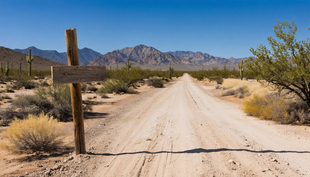
How to Get to Mowry From Patagonia
Reaching Mowry from Patagonia takes you 14 miles south through the rugged terrain of Santa Cruz County and into the Coronado National Forest.
You’ll follow Forest Road 214, turning left at mile 12.8 onto FR49 from Harshaw. From there, a steep dirt path awaits at the intersection of Harshaw and Apache roads, heading east toward the remnants of Mowry Mining history.
At mile 12.8, turn left onto FR49 — a steep dirt path leading east toward Mowry Mining history.
This route isn’t just a drive — it’s a journey retracing the footsteps of early settlers who carved lives from unforgiving desert land.
The road demands a capable vehicle and a spirit willing to embrace the unexpected. Keep your eyes open along the way, because the landscape itself tells stories that no guidebook fully captures.
Freedom-seekers will find the effort richly rewarded.
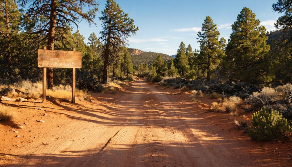
Once you’ve left Patagonia heading south, you’ll follow Forest Road 214 for roughly 12.8 miles until you reach the left turn onto FR49, a rough dirt route that carries you deeper into the Coronado National Forest toward the old Mowry site.
The road isn’t forgiving, so you’ll want a high-clearance vehicle as you navigate the steep, unpaved terrain that threads through scrubby desert hills.
When you reach the intersection of Harshaw and Apache roads, look east for the faint path that climbs toward the scattered adobe ruins, stone foundations, and collapsed shafts that mark what was once a thriving silver-mining town.
Starting From Patagonia
Tucked within the folds of the Coronado National Forest in Santa Cruz County, Mowry sits roughly 14 miles south of Patagonia — and getting there’s half the adventure.
You’ll head south from Patagonia, following Forest Road 214 through rugged high desert terrain that feels untouched by modern time. At mile 12.8, turn left onto FR49 from Harshaw, where the landscape shifts into something wilder.
Mowry legends echo across these dusty ridgelines, whispering stories of silver strikes, Apache raids, and ghost town survival against impossible odds. The roads are steep and unpaved, so bring a capable vehicle and your sense of adventure.
Every turn rewards you with sweeping views and quiet reminders that you’re retracing paths walked by miners, soldiers, and dreamers long forgotten.
Forest Road 214 is your lifeline into Mowry’s forgotten world, and knowing how to read it makes all the difference.
You’ll head south from Patagonia roughly 14 miles through Coronado National Forest, where the landscape shifts from scrubby grasslands into rugged canyon country. Your key navigation tip: watch carefully at mile 12.8 for FR49, turning left toward Harshaw first before pushing onward to Mowry.
Trail conditions here demand respect. The road turns to steep, uneven dirt, and a high-clearance vehicle isn’t optional — it’s essential.
Seasonal rains can transform passable paths into slick obstacles overnight. Keep your bearings at the intersection of Harshaw and Apache roads, where a steep dirt path angles east toward the ruins.
Move deliberately, stay alert, and the road rewards you.
Finding The Ruins
Arriving at the intersection of Harshaw and Apache roads, you’ve reached the critical turning point where Mowry’s ruins finally come within reach.
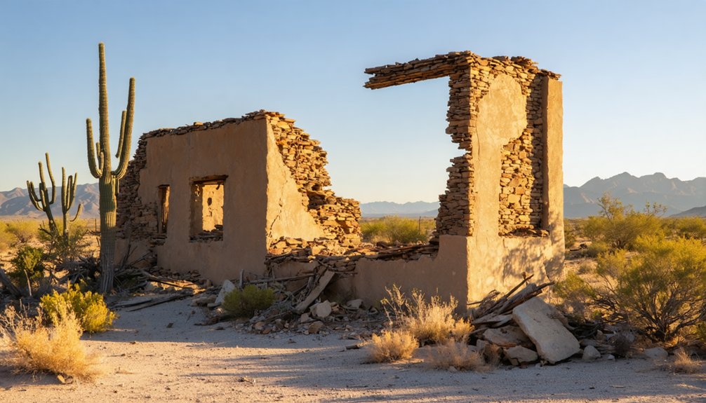
Take the steep dirt path heading east, and you’ll descend into a landscape frozen in the 1860s. Your ruins exploration begins among crumbling adobe walls, scattered stone foundations, and a collapsed mine shaft that once drove a million-dollar silver operation.
A powder house still stands nearby, quietly asserting its historical significance against the Arizona sky. Slag piles crown the hilltop mine site, remnants of 12 blast furnaces that roared with industrial ambition.
Don’t miss the Mowry cemetery, situated one mile east of the road — its weathered markers tell the personal stories behind this forgotten outpost’s rise and ruin.
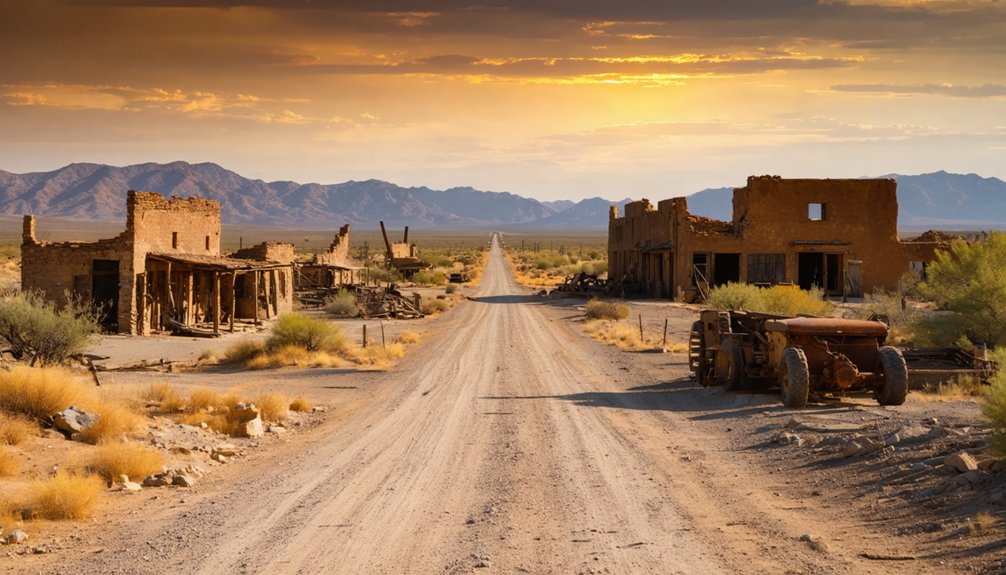
What Remains at the Mowry Ghost Town Site
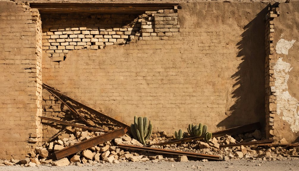
Silence greets you at the Mowry site, broken only by wind cutting through crumbling adobe walls and the occasional creak of weathered stone. The Mowry ruins speak volumes without saying a word.
You’ll find scattered stone foundations, a collapsed mine shaft, and a surviving powder house standing defiantly against time.
Climb the hilltop to discover slag piles marking where 12 blast furnaces once roared, processing silver and lead for a nation. Historical artifacts aren’t behind museum glass here — they’re beneath your boots and within arm’s reach of weathered walls.
Slag piles crown the hilltop where 12 blast furnaces once roared — history here isn’t preserved behind glass, it’s underfoot.
One mile east, the Mowry cemetery holds quiet testimony to those who built this place.
A one-room adobe schoolhouse, built in 1918 and abandoned by 1920, reminds you how quickly frontier dreams could dissolve.
What the Mowry Cemetery Tells You About Life Here
A mile east of the ruins, you’ll find the Mowry cemetery, where weathered headstones and elaborate decorations mark graves stretching back to the 1880s.
The stones tell a quiet, unvarnished story of pioneer life—short lives, hard labor, and a community clinging to survival in Arizona’s unforgiving borderlands.
Walk among them, and you’ll feel the weight of an era when silver fever drew families to a remote canyon that ultimately broke as many as it rewarded.
Graves From Harsh Eras
The Mowry Cemetery, sitting one mile east of the main ruins, holds more than just names and dates — it holds the unfiltered story of what life in this remote Arizona mining settlement actually cost.
When you walk among these graves, the cemetery significance hits hard. You’re reading lives cut short by Apache raids, mining accidents, and brutal isolation.
The graves history stretches back through Apache conflicts, Civil War disruptions, and economic collapse — each marker a quiet testimony to resilience and loss.
These weren’t people chasing comfort; they were chasing freedom in one of America’s most unforgiving landscapes.
You’ll notice the elaborate decorations still maintained today, proof that even in abandonment, someone hasn’t forgotten what these settlers sacrificed to carve out existence here.
Elaborate Cemetery Decorations
What you’ll find decorating these graves isn’t neglect — it’s devotion fossilized in desert heat. The Mowry cemetery, sitting one mile east of the ruins, holds elaborate symbolism pressed into iron, stone, and faded paint. Cemetery art here doesn’t whisper — it testifies.
You’ll trace hand-wrought metalwork, carved inscriptions, and personal tokens left by people who understood loss intimately. These weren’t wealthy settlers erecting monuments. They were miners, families, and drifters who died far from comfort and got buried by neighbors who cared anyway.
Every decoration tells you something raw about who survived here and who didn’t. Walk slowly. Read the dates. Let the elaborate symbolism sink in — because this cemetery isn’t a relic. It’s a reckoning with what frontier freedom actually cost.
Pioneer Life Revealed
Graves don’t just mark death — they map the shape of a life. Walk through Mowry’s cemetery, and you’ll read the unfiltered story of pioneer challenges etched into every headstone.
You’ll notice the dates — lives cut short by mining accidents, disease, and brutal desert conditions. Daily survival here wasn’t romantic; it was relentless. Men hauled ore through punishing heat. Women raised children in adobe structures with dirt floors.
The cemetery’s well-maintained plots, decorated with care despite their remoteness, tell you something important: these people held onto dignity even when circumstances stripped everything else away.
Standing among graves dating to 1885, you feel the weight of their choices — leaving everything familiar to chase something uncertain in Arizona’s unforgiving frontier.
What to See at Harshaw Before You Reach Mowry
Before reaching Mowry, you’ll want to slow down and spend some time in Harshaw, a ghost town with its own compelling story.
Harshaw history runs deep — David Harshaw founded it in 1877, and by 1880, nearly 2,000 people called it home. A post office, newspaper, saloons, and stores once lined its streets.
Then came 1882. A devastating fire and collapsing silver prices gutted the town’s momentum. By 1903, even the post office had gone quiet.
Today, Harshaw structures tell that story through crumbling adobe walls, stone foundations, and a large stone building still standing with walls intact.
Don’t miss the well-maintained cemetery, where graves dating to 1885 and their elaborate decorations remind you that real lives unfolded here.
Nearby Ghost Towns: Washington Camp and Duquesne
Two more ghost towns sit within striking distance of Mowry: Washington Camp and Duquesne.
These neighboring settlements once hummed with mining activity, and their Duquesne History mirrors Mowry’s boom-and-bust rhythm. You’ll find remnants of a world built fast and abandoned faster.
Swing through both towns to complete your picture of this rugged frontier corridor:
- Washington Camp served as a smelting hub, processing ore from surrounding mines during peak silver production years.
- Duquesne History reveals a company-built town with substantial structures, now crumbling quietly into the Sonoran landscape.
Both ghost towns sit close enough to explore in a single afternoon, rewarding curious travelers willing to wander dirt roads.
Don’t rush this stretch — every ruin tells a story worth reading.
What to Bring for Hiking the Mowry Mine Site
Hiking to the Mowry Mine site means trading comfort for consequence — steep dirt paths, crumbling adobe edges, and Sonoran sun that doesn’t forgive the unprepared. Your hiking essentials should reflect that reality. Carry at least two liters of water, sun protection, and sturdy boots with ankle support. The terrain east of the Harshaw and Apache roads intersection demands traction, not trail runners.
For trail safety, bring a physical map since cell service disappears fast in Coronado National Forest. A first aid kit, whistle, and charged backup battery round out your pack.
You’re walking through collapsed shafts and slag piles — ruins that reward the careful explorer, not the careless one. Respect the site, and it’ll give you something worth remembering.
When to Visit Mowry: Road Conditions and Seasonal Access
Timing your visit to Mowry can mean the difference between a rewarding ghost town exploration and a truck stuck axle-deep in monsoon mud.
Weather considerations dramatically shape your experience on Forest Road 214’s steep dirt path. Trail conditions shift fast in southern Arizona.
- Spring (March–May): Ideal weather considerations and firm trail conditions make ruins accessible.
- Monsoon Season (July–September): Heavy rains devastate trail conditions, turning roads impassable overnight.
- Winter (December–February): Cold temperatures create manageable trail conditions, though occasional snow closes higher elevations.
You’re chasing history across land that doesn’t accommodate unpreparedness.
Check road conditions through Coronado National Forest’s ranger stations before departing. That extra phone call keeps your adventure moving forward rather than backward.
Frequently Asked Questions
Is Camping Allowed Overnight Near the Mowry Ghost Town Ruins?
The knowledge doesn’t confirm camping regulations near Mowry’s ruins, so you’ll want to check with Coronado National Forest directly. Follow safety tips, respect the historic grounds, and embrace the freedom of sleeping beneath Arizona’s vast, starlit desert sky.
Are There Guided Tours Available for Visiting Mowry Ghost Town?
Sadly, no polished tour buses await you! You’ll explore Mowry’s ghost town history independently, uncovering mining artifacts on your own terms — raw, unfiltered freedom echoing through crumbling adobe walls and slag-covered hillsides that no guided script could ever capture.
Can Children Safely Explore the Mowry Mine Site With Families?
You can bring your family, but prioritize family safety — steep paths, collapsed shafts, and crumbling adobe walls pose real risks. Still, you’ll cherish exploring the historical significance of this nostalgic, freedom-filled frontier with wide-eyed kids beside you.
Is a Permit Required to Visit Mowry Within Coronado National Forest?
You don’t need a permit application to visit Mowry! Simply drive into Coronado National Forest and you’re free to explore its ghost town history, wandering adobe ruins and slag piles at your own adventurous pace.
Are Pets Allowed on Hiking Trails Leading to Mowry Ruins?
Ready to roam free? Pets are generally allowed on Coronado National Forest trails, but you’ll want to follow pet friendly policies and hiking trail etiquette — keep your furry companion leashed while exploring Mowry’s haunting ruins.
References
- https://www.gvrhc.org/Library/GhostTowns.pdf
- https://www.ghosttowns.com/states/az/mowry.html
- https://www.youtube.com/watch?v=i93wbwozujA
- https://www.arizonahighways.com/classroom/mowry-az
- https://tucson.com/news/local/mine-tales-mowry-made-quite-a-profit/article_8fcb4ce1-99a2-5f15-ae54-86d486e24c5e.html
- https://www.apcrp.org/MOWRY012516/Mowry_Text_Master_012316_F.htm
- https://www.visittucson.org/listing/ghost-towns-of-harshaw-mowry-washington-camp-and-duquesne/6299/


