Yocemento, Kansas sits between Hays and Ellis off I-70, where limestone bluffs still hold the fractured concrete bones of a cement plant that couldn’t survive past 1917. Founded in 1906 by Erasmus Haworth and I.M. Yost, this ghost town rose on geological ambition and fell just as fast. You’ll navigate without polished signs, so bring sturdy boots, water, and your coordinates: 38°54′26″N, 99°25′26″W. Everything you need to make this road trip unforgettable is just ahead.
Key Takeaways
- Yocemento, founded in 1906 for cement production, went bankrupt by 1917, making it a compelling ghost town destination near Hays, Kansas.
- Access Yocemento via I-70 west from Hays, using coordinates 38°54′26″N, 99°25′26″W and watching for the Hog Back ridge landmark.
- Explore concrete foundations, fractured masonry ruins, and a 1000 CE hunting camp site with ancient stone tools and animal bones.
- Extend your road trip by visiting nearby ghost towns Hyacinth and Easdale, while enjoying local wildlife including hawks and deer.
- Pack sturdy hiking boots, water, snacks, sunscreen, a camera, notebook, paper map, and a charged phone before exploring.
Why Yocemento Was Built: and Why It Disappeared
When two ambitious men looked at the limestone bluffs rising above Big Creek in Ellis County, Kansas, they didn’t see scenery—they saw a fortune waiting to be quarried.
In 1906, state geologist Erasmus Haworth and Hays miller I.M. Yost founded Yocemento with clear economic motivations: manufacture Portland cement from the Fort Hays Limestone dominating those bluffs. The town’s name literally spelled out its purpose.
The town’s name said it all: Yocemento existed for one reason—turn limestone into Portland cement and profit.
But the dream collapsed fast. The cement plant went bankrupt, the post office shuttered in 1917, and residents scattered.
What remains carries genuine historical significance—ruins sitting at the base of bluffs that were shaping human activity as far back as 1000 CE.
You’re not just visiting a failed business venture; you’re standing where ambition, geology, and time collided hard.
How To Get To Yocemento From Hays
Knowing why Yocemento collapsed makes standing among its ruins feel different—but first you’ve got to get there.
From Hays, head west along I-70 toward Ellis. Yocemento sits roughly halfway between both towns, tucked against the base of limestone bluffs where Big Creek runs through.
Watch for the old Hog Back ridge area—that’s your landmark. The Fort Hays Limestone formations rising from the creek bank signal you’re close.
No polished roadside signs mark this destination; ghost town exploration demands you pay attention. Pull off, walk toward the bluffs, and let Yocemento history unfold around you through crumbling cement plant ruins and ancient creek-bottom terrain.
The coordinates 38°54′26″N, 99°25′26″W keep you precise if you’re guiding yourself digitally through Ellis County’s open landscape.
The Cement Plant That Built and Broke Yocemento
The cement plant wasn’t just Yocemento‘s economic engine—it was the entire reason the town existed. In 1906, state geologist Erasmus Haworth and Hays miller I.M. Yost saw opportunity in the Fort Hays Limestone bluffs towering over Big Creek. They believed those massive stone formations could fuel a thriving cement industry, producing Portland cement for a growing nation.
The town’s very name reflects that singular purpose—”Yocemento” blending Yost’s name with cement production. The historical significance of their vision is undeniable; they were betting everything on local geology.
A town named for its sole purpose—where identity and industry were carved from the same stone.
But the gamble failed. The plant went bankrupt, the post office shuttered in 1917, and residents scattered.
Today, you’ll find only ruins crumbling at the base of those same limestone bluffs—a quiet monument to ambition that couldn’t outlast its own foundation.
Before the Cement Plant: 1,000 Years of Hunting Camps at Yocemento
Long before Erasmus Haworth and I.M. Yost ever broke ground on their cement plant, hunters were already working this same stretch of Big Creek’s banks around 1000 CE, butchering bison and deer at what’s now recognized as a significant archaeological site.
You’ll find evidence that these seasonal visitors didn’t just camp here — they actively manufactured stone tools on-site, using quartzite, flint, silicified Smoky Hill Chalk, and silcrete, even heat-treating materials to improve their quality.
The site shows no signs of permanent occupation, marking it instead as a warm-season hunting camp where skilled people returned repeatedly to exploit the same natural landscape you’re standing in today.
Ancient Bison Hunting Grounds
Before the cement plant ever broke ground, people were already drawn to this spot along Big Creek for a very different kind of industry. Around 1000 CE, hunters used this location as a warm-season camp, working the landscape with a sharp understanding of bison behavior and proven hunting techniques.
You’d find evidence of that life scattered across the site — bison bones, deer remains, and stone tools crafted from quartzite, flint, and silicified Smoky Hill Chalk.
Hunters even heat-treated their materials here, refining tools on the spot. This wasn’t a permanent settlement; it was a working camp, activated by seasonal movement and necessity.
The same bluffs that later drew cement investors first drew skilled hunters who knew exactly how to use this land.
Stone Tools And Materials
Scattered across the site, stone tools tell a story of deliberate skill and resourcefulness that predates the cement plant by nearly a millennium. The people who camped here during warm seasons didn’t just hunt — they crafted.
You’ll find evidence of quartzite tools alongside implements made from flint, silicified Smoky Hill Chalk, and silcrete, each material carefully selected for its working qualities.
What’s particularly striking is the heat treatment of these materials. Ancient craftspeople deliberately exposed stone to controlled heat, improving its flaking properties before shaping it into cutting and scraping tools.
This wasn’t accidental — it reflects sophisticated knowledge passed across generations. Walking this ground, you’re standing where skilled hands once transformed raw stone into precision instruments, long before anyone dreamed of manufacturing cement here.
Warm Season Camp Evidence
The bones and tools left behind at Yocemento paint a vivid picture: roughly a thousand years ago, hunters returned here each warm season to butcher bison, deer, and small mammals against the backdrop of these same limestone bluffs.
This wasn’t a permanent settlement — it was a free-ranging hunting camp, used intentionally and abandoned just as deliberately.
Picture the scene archaeologists pieced together:
- Hunters arrived during warm months, following bison migrations across the High Plains
- They processed kills on-site, leaving behind scattered animal bones and worked stone
- Nobody stayed permanently — they took what they needed and moved on
You’re standing where those same cycles played out for generations, long before cement kilns and railroad surveys ever entered the picture.
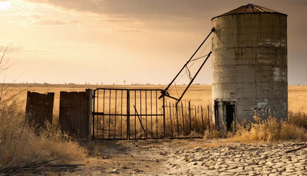
The Limestone Bluff Ruins You Can Still See Today
When you pull up to the base of the bluffs at Yocemento, the Fort Hays Limestone outcrop rises dramatically above Big Creek, making it easy to see why early 20th-century entrepreneurs believed they’d struck gold in stone.
You can still spot the crumbling remnants of the cement plant scattered along the bluff base, silent evidence of a business venture that went bankrupt before it ever truly got started.
As you walk the area, you’re also standing on ground that holds archaeological features dating back 1,000 years, where ancient hunters once butchered bison and shaped stone tools against these same limestone walls.
Fort Hays Limestone Outcrop
Rising above Big Creek’s banks, the Fort Hays Limestone bluffs stand as Yocemento’s most dramatic and enduring feature — the same massive stone that drew Erasmus Haworth and I.M. Yost here in 1906.
This limestone geology shaped everything — the town’s founding, its economy, and its fate.
When you visit, you’ll notice:
- Layered bluff faces exposing ancient seabed formations unique to Kansas’s High Plains
- Bluff ecosystems clinging to rocky ledges, where native grasses and wildlife reclaim the ruins
- Scattered cement plant remnants still embedded against the stone base
You’re standing where indigenous hunters camped around 1000 CE, where industrialists gambled and lost, and where limestone outlasted them all.
The bluffs don’t just frame the landscape — they *are* the story.
Cement Plant Remnants Visible
Scattered along the base of the Fort Hays Limestone bluffs, the broken remnants of Yocemento’s cement plant still push through the soil and scrub — concrete foundations, fractured masonry, and weathered structural debris that mark where Haworth and Yost’s industrial ambition collapsed into bankruptcy.
You’ll find no interpretive signs or guided tours here — just raw, unfiltered cement history sitting quietly beneath open Kansas sky. That freedom to explore on your own terms makes Yocemento uniquely rewarding.
Walk the creek bank, read the landscape, and let the ruins speak for themselves. This town legacy isn’t preserved behind glass — it’s exposed to wind, weather, and whoever’s curious enough to seek it out.
Bring water, wear sturdy shoes, and take nothing but photographs.
Bluff Base Archaeological Features
The limestone bluffs looming above those cement ruins aren’t just a dramatic backdrop — they’re a story older by a thousand years. Bluff archaeology here reveals a warm-season hunting camp dating to around 1000 CE, where ancient hunters processed game and crafted tools.
Walk the base and you’re standing where they worked. The hunting evidence left behind includes:
- Animal bones from bison, deer, and small mammals
- Stone tools crafted from quartzite, flint, and silicified Smoky Hill Chalk
- Heat-treated materials, showing sophisticated on-site tool manufacturing
Nobody lived here permanently — they came, hunted, worked, and moved on. That freedom of movement echoes across ten centuries, making Yocemento’s bluffs far more layered than they first appear.
Nearby Ellis County Ghost Towns Worth Combining With Yocemento
While Yocemento makes for a fascinating stop, Ellis County’s ghost town circuit doesn’t end there. Nearby Hyacinth and Easdale offer additional historic landmarks that round out your road trip beautifully.
These forgotten settlements share Yocemento’s story of ambitious beginnings and quiet abandonment, giving you a richer picture of the region’s past.
As you drive between sites, keep your eyes open for local wildlife roaming the High Plains landscape. Hawks circle above limestone bluffs while deer move through creek bottoms, adding unexpected life to these empty townscapes.
Pairing these stops with Yocemento makes practical sense since all three sit within easy driving distance of Hays.
You’ll cover significant history without backtracking, turning a single afternoon into a genuinely memorable Ellis County ghost town experience.
What To Bring for Yocemento’s Bluff Terrain and Ruins
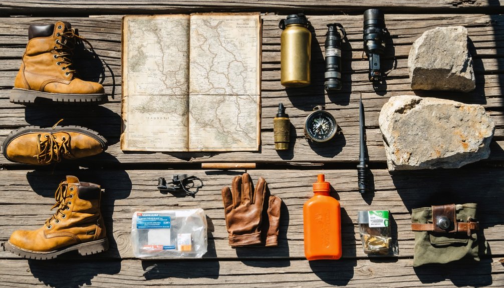
Exploring Yocemento’s limestone bluffs and crumbling cement plant ruins calls for 5 essential items you won’t want to leave behind.
Bluff hiking here means uneven terrain, loose rock, and surprising elevation changes against Big Creek’s banks. Pack smart and you’ll move freely through this site’s rich historical significance.
- Sturdy hiking boots with ankle support for traversing Fort Hays Limestone outcrops
- Water and snacks since no services exist at this remote, extinct Ellis County community
- Camera and notebook to document the ruins, bluff formations, and archaeological context dating back to 1000 CE
You’ll also want sunscreen, a paper map, and a charged phone.
The ruins don’t wait forever, and neither does daylight on the High Plains.
Frequently Asked Questions
Did Erasmus Haworth’s Predicted Oil Discovery at Yocemento Ever Materialize?
Ironically, Haworth’s oil predictions never struck gold—or black gold! You’ll find no gushing wells at Yocemento, just historical significance wrapped in limestone ruins and a bankrupt cement plant’s ghost whispering forgotten dreams of fortune.
What Railroad Line Previously Operated at the Hog Back Station Location?
The knowledge doesn’t specify which railroad line operated at Hog Back Station, but you’ll find this ghost town’s railroad history fascinating as you explore Yocemento’s remnants, where the former station site still echoes adventure.
Were Any Other Businesses Besides the Cement Plant Established in Yocemento?
Like a lone star in the night, the cement plant was Yocemento’s sole heartbeat. You won’t find records of other businesses—just its historic architecture, local legends, and a post office serving the community until 1917.
What Exact Coordinates Mark the Center of the Yocemento Ghost Town Site?
You’ll find Yocemento’s ghost town history centered at 38°54′26″N, 99°25′26″W, where urban decay quietly claims the limestone bluffs above Big Creek. Navigate there to witness freedom’s frontier slowly surrendering to time’s unstoppable grasp.
How Many Residents Lived in Yocemento During Its Peak Operating Years?
The available records don’t reveal Yocemento’s peak population, but you’ll appreciate its historical significance as a bustling cement hub. Its population decline followed bankruptcy, leaving you free to explore this hauntingly beautiful, abandoned Kansas treasure.
References
- https://en.wikipedia.org/wiki/Yocemento
- https://www.youtube.com/watch?v=8dtIPX7pIqI
- https://thewanderingpigeon.com/2015/10/03/day-of-kansas-ghost-towns/
- https://legendsofkansas.com/ellis-county-extinct-towns/
- https://kids.kiddle.co/Yocemento


