You’ll find New Chicago three miles south of Plymouth in Amador County, where gold-bearing quartz discoveries in the 1850s created this mining settlement at 948 feet elevation. Take New Chicago Road from Drytown’s center for 2.5 miles, though 4WD’s recommended on these minimally maintained routes. Spring and fall offer the best visiting conditions between 60-75°F, while you’ll need to navigate carefully around private property boundaries using GPS and current parcel maps. The sections below detail everything you’ll need for documenting this deteriorating historical site.
Key Takeaways
- New Chicago is a gold rush ghost town located 3 miles south of Plymouth in Amador County at 948 feet elevation.
- Access the site via New Chicago Road from Drytown’s center; 4WD is recommended for the 2.5-mile unmaintained route.
- Explore weathered mill sites, a prominent head frame, homestead foundations, and mining waste scattered across the compact footprint.
- Visit during spring or fall for ideal temperatures between 60-75°F and optimal accessibility before summer heat or winter snow.
- Verify property boundaries using California Topo maps and obtain landowner permission, as sites often occupy private land.
The History Behind New Chicago’s Mining Legacy
When prospectors discovered gold-bearing quartz in Amador County’s rolling foothills during the 1850s, they established a mining camp near what would become the Grover Mine, three miles south of Plymouth at 948 feet elevation. The mining camp significance grew when developers formalized New Chicago in 1877 as a subdivision supporting the Grover Mine operations.
Getting There: Directions and Road Conditions
You’ll find New Chicago approximately 3 miles south of Plymouth along historic routes that once served Amador County’s mining operations. The roads accessing this ghost town remain passable throughout the year, though their condition reflects decades of minimal maintenance since the mining era ended.
Document your route carefully from Drytown, as modern GPS systems may not recognize these lesser-traveled pathways that connect California’s Gold Country settlements.
Route From Drytown
From Drytown’s center at Highway 49, New Chicago Road provides the most direct access to this nearly forgotten gold rush settlement. You’ll navigate 2.5 miles north from this historical landmark community, following the primary route that once connected miners to their claims.
The road intersects with Old Drytown Plymouth Road and Spanish Street—critical junctions for orientation in this sparsely marked territory.
Alternative driving routes remain limited due to the area’s original 1850s layout and rugged foothill topography at 646 feet elevation. Public transportation options don’t exist here; you’ll need your own vehicle to document these remnants of California’s mining heritage.
Modern mapping tools like MapQuest and Google Maps offer real-time navigation, though cellular service proves unreliable. Pack printed topo maps for independent exploration of this remote Amador County location.
Road Accessibility Year-Round
Graded dirt roads connecting to New Chicago maintain passable conditions throughout most calendar months, though seasonal variations demand careful trip planning. You’ll find 4WD recommended for reliable access, as these routes lack the transportation infrastructure upgrades common to paved highways.
Winter brings snow accumulation from January through April, particularly at higher elevations, while spring thunderstorms between March and June can trigger washouts requiring road maintenance obligations. Unlike high Sierra passes that experience multi-day closures, New Chicago’s foothill location typically guarantees year-round accessibility.
Monitor Caltrans QuickMap at roads.dot.ca.gov or call 1-800-427-7623 for real-time conditions on CA-49 and CA-88 approaches. Chain requirements may activate during storms on nearby passes, so you’ll want to check before departing Jackson for this 10-15 mile journey into California’s mining history.
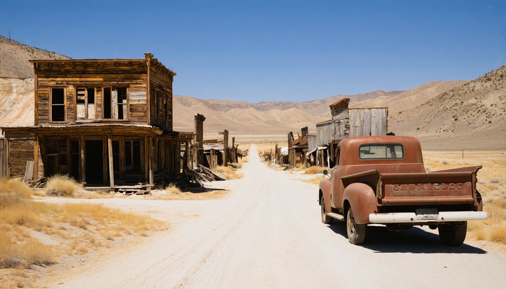
What Remains: Structures and Ruins to Explore
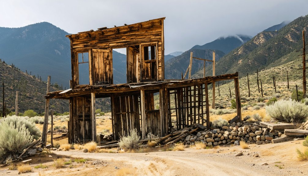
Though time and the elements have claimed much of New Chicago, the settlement’s skeletal remains still punctuate the Amador County landscape. You’ll find weathered mill sites where ore processing occurred during the Gold Rush, their structures documenting 19th-century industrial activity.
A prominent head frame stands as a memorial to vertical mining operations, its wooden framework hoisting ore and miners from underground shafts.
Scattered homestead foundations reveal where families established lives near the diggings—concrete and stone bases marking former residential quarters. Additional foundations supported commercial buildings across the town’s compact footprint, though erosion obscures many details.
These remnants hold historical significance beyond aesthetics. Mining waste visible nearby demonstrates the environmental impact of gold extraction, offering documentation of both pioneer ambition and its lasting consequences on Amador County’s terrain.
Best Time to Visit This Amador County Ghost Town
Your visit to New Chicago’s remnants requires careful timing, as Amador County’s Sierra Nevada foothills experience distinct seasonal variations that affect site accessibility and documentation conditions.
Spring and fall offer ideal temperature ranges between 60-75°F, allowing extended periods for photographing structures and examining architectural details without weather-related constraints.
Summer temperatures exceeding 95°F and winter snow accumulation can compromise both preservation observations and safe navigation of the deteriorating townsite.
Seasonal Weather Considerations
Planning your visit to New Chicago requires understanding Amador County’s distinct seasonal patterns, as weather conditions directly impact accessibility to historical structures and photographic documentation opportunities. Precipitation patterns remain minimal year-round, though winter months introduce snow accumulation risks. Cloud cover dynamics shift dramatically between seasons, affecting natural lighting for architectural documentation.
Consider these seasonal factors for ideal preservation work:
- Spring (March-May): Extended daylight until 7:59 PM enables thorough photographic surveys with moderate UV index levels (3-7)
- Summer (June-August): Overcast conditions reduce harsh shadows while maintaining 72°F-82°F temperatures
- Fall (September-November): Clear skies provide superior visibility for detail documentation
- Winter (December-February): Temperatures dropping to 18°F and reduced daylight until 4:49 PM limit exploration windows
Avoiding Extreme Temperatures
The thermal extremes of Amador County’s foothills demand strategic scheduling to protect both visitor comfort and documentation equipment during preservation surveys of New Chicago’s remaining structures. You’ll encounter scorching summer days exceeding 95°F that threaten camera sensors and create hazardous conditions during extended field documentation.
Winter temperatures plummet below freezing, compromising battery performance and making detailed architectural photography challenging. Spring and fall deliver moderate conditions ideal for thorough site surveys without thermal interference.
Dressing in layers provides temperature flexibility as you move between shaded mine entrances and exposed hillside structures. Staying hydrated becomes critical during any season—dehydration impairs your ability to conduct accurate measurements and photographic documentation.
Early morning arrivals grant prime lighting conditions while avoiding afternoon heat peaks that distort thermal imaging equipment and compromise preservation assessment accuracy.
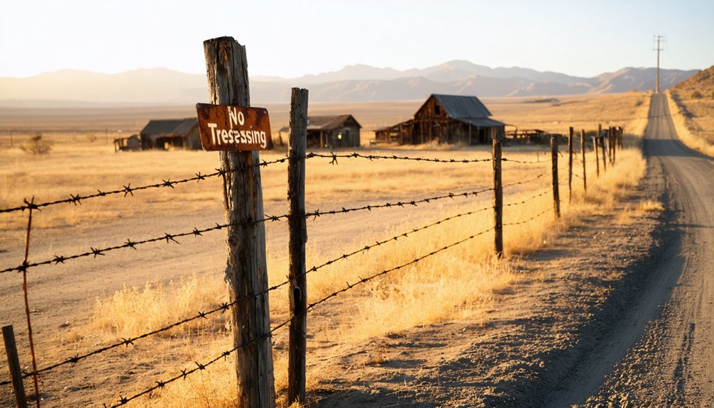
Before venturing into ghost town territory, you’ll need to master the boundary lines separating accessible public lands from restricted private parcels. California Topo maps provide color-coded overlays showing ownership boundaries with landowner names, while GPS tools confirm your position relative to restricted areas. Parcel mapping databases receive yearly updates ensuring accurate navigation.
Master boundary lines between public and private lands using color-coded topo maps and GPS tools before exploring ghost town sites.
To explore New Chicago’s remnants responsibly:
- Consult statewide parcel datasets compiled through California’s Information Center
- Identify property owners using parcel layers before site visits
- Request private landowner approval through documented contact information
- Navigate around unauthorized areas using marked boundary coordinates
Historical ghost town sites often occupy privately-held land requiring explicit permission. Plat coverage maps detail precise ownership boundaries, preventing inadvertent trespassing while documenting California’s abandoned settlement patterns.
Nearby Attractions and Ghost Towns Worth Visiting
Once you’ve secured proper access permissions and documented boundary coordinates, your ghost town expedition can expand to include California’s most thoroughly preserved mining settlements. Calico Ghost Town, minutes off Interstate 15 near Barstow, operates as a documented 1880s silver mining settlement with preserved structures and mining equipment from the state’s largest silver strike.
The Lucy Lane Museum provides free access to archived photographs, original documents, and artifacts cataloging the town’s origins. You’ll find museum exhibits within Maggie Mine’s 1880s silver operations, featuring mannequins depicting authentic miner conditions. Saturday evening ghost tours document haunted sites throughout the settlement.
The Bottle House stands as photographable architectural evidence of frontier resourcefulness. Beyond commercial operations, hiking trails access scenic overlooks and the surrounding Calico Ghost Town Regional Park offers off-roading and primitive camping opportunities.
Essential Tips for Your New Chicago Adventure

Planning your New Chicago expedition requires acknowledging a fundamental distinction: this remote ghost town offers none of Calico’s commercial infrastructure or maintained access roads. You’ll find no pet friendly policies, modern amenities, or visitor centers—just authentic decay and solitude.
Exploring ghost towns near Mcleans Ferry can be a surreal experience, revealing the remnants of past lives and stories waiting to be uncovered. Each structure tells a tale of days gone by, standing as a testament to the resilience of nature reclaiming what was once bustling with activity. As you wander through the abandoned streets, the sense of isolation can be both haunting and liberating, inviting reflection in a way that few other places can.
New Chicago delivers unfiltered abandonment—no infrastructure, no amenities, no conveniences. Just weathered structures and uncompromising desert silence awaiting the prepared explorer.
Essential preparation includes:
- Navigation equipment: GPS coordinates and offline maps, as cell service remains unreliable in remote Mojave territories
- Self-sufficiency supplies: Abundant water (minimum one gallon per person), high-energy food, and thorough first-aid provisions
- Documentation tools: Camera equipment for architectural recording, notebook for structural observations, proper lighting for interior photography
- Emergency protocols: Verified departure/return times with contacts, vehicle recovery equipment, satellite communication devices
Respect preservation by leaving artifacts undisturbed. You’re documenting history, not collecting it.
Frequently Asked Questions
Are There Any Restroom Facilities Available at the New Chicago Ghost Town Site?
No restroom facilities exist at New Chicago Ghost Town. You’ll find no wheelchair accessibility, public drinking water, or modern amenities at this undeveloped Bureau of Land Management site. You must pack portable toilets and supplies to preserve this historic location.
Can I Camp Overnight Near New Chicago or in the Surrounding Area?
You’ll find dispersed camping spots available throughout the surrounding public lands, offering freedom to explore. Nearby RV campgrounds like Sawtooth Canyon provide documented facilities while you’re researching New Chicago’s preserved historical remnants and archival significance.
Is Cell Phone Reception Available at New Chicago for Emergencies?
Picture yourself standing among weathered ruins—you’ll find minimal cell reception here. For emergencies, don’t rely on standard coverage. Instead, you’ll need satellite coverage availability to guarantee emergency call reliability. Document your coordinates before venturing into this remote historical site.
Are Pets Allowed When Visiting the New Chicago Ghost Town Ruins?
No documented pet-friendly policies exist for New Chicago’s ruins, as historical records lack animal restrictions data. You’ll need to contact local land management directly to verify current access rules before exploring these unpreserved remnants independently.
What Photography Equipment Works Best for Capturing the Remaining Structures?
You’ll want mirrorless camera lenses like wide-angle 15mm options for full facade documentation, plus tripod stability considerations guarantee sharp long exposures. Full-frame sensors capture weathered details while preserving New Chicago’s architectural heritage for future generations.


