You’ll need to specify which Newport you’re targeting—Clay County’s acronym-named settlement 20 miles northeast of Wichita Falls via US 287, Walker County‘s 1846 river town accessible from Huntsville along FM 405, or Houston’s infamous Black Hope Cemetery subdivision where residents discovered 60 unmarked graves in 1983. Clay County requires standard vehicles on paved highways, while Walker County demands high-clearance transport for challenging 5-mile dirt stretches. The guide below breaks down each location’s haunted history, remaining structures, and seasonal access considerations.
Key Takeaways
- Texas has three Newports; Walker County’s 1846 river settlement is the most authentic ghost town worth visiting.
- Access Walker County’s Newport via FM 405 northeast from Huntsville, then navigate challenging dirt roads requiring high-clearance vehicles.
- Clay County’s Newport remains inhabited with 70 residents, making it less of a ghost town despite population decline.
- Avoid farm roads and low water crossings during wet seasons due to flooding risks and deteriorating road conditions.
- Walker County’s site features historical markers six miles southeast of Riverside commemorating the abandoned 1850s river commerce hub.
Three Different Newports: Which Ghost Town Are You Visiting?
Before you pack your bags for Newport, Texas, you’ll need to determine which Newport you’re actually chasing. Walker County’s Newport earned its ghost town status after river navigation declined—founded in 1846 by German emigrant Joseph Werner along the Trinity River.
The railroad-era Newport emerged in 1872 on the Trinity’s west bank, courtesy of the Houston and Great Northern Railroad, only to fade when rail lines shifted. Wise County’s Newport, established around 1865 in North Texas, vanished by the 1900s after being bypassed entirely.
These regional differences matter greatly for exploration. Walker County offers pre-railroad history in East Texas, while the railroad Newport represents 1870s transport evolution, and Wise County’s barren site sits in distinctly different North Texas territory. Each location tells its own abandonment story.
Newport in Clay County: The Acronym Town Built by Seven Families
Unlike the Rhode Island resort that shares its name, Clay County’s Newport earned its unusual moniker through an acronym—merging the initial letters from seven prominent families’ surnames when the post office establishment occurred in 1879. L. Hancock founded the settlement in 1872 as Bear Hill, but seven founding families transformed it into something uniquely Texan.
This naming technique mirrors how the music group NSYNC formed their name—taking first letters from key leaders’ names. The community’s peak came in the 1920s with 280 residents and held steady until the mid-1940s. By the 1950s, population plummeted to 85, with only three businesses surviving.
Today, you’ll find roughly 70 souls inhabiting this unincorporated community at coordinates 33°28′04″N 98°00′59″W within the Wichita Falls metropolitan area.
Newport in Walker County: A German Settler’s Dream on the Trinity River
While Clay County’s Newport drew its identity from an alphabetic fusion of family names, Walker County’s version tells a distinctly different story—one rooted in the ambitious vision of Joseph Werner, a German emigrant who established his settlement in 1846 along the Trinity River’s left bank. Werner joined the German merchant class flooding into the Trinity basin following Texas’s independence in 1836, recognizing opportunity in prosperous river commerce.
His settlement thrived during the 1850s and 1860s as steamboats and flatboats transported cotton from surrounding farms to coastal markets. The town developed wharves, churches, schools, and commercial establishments. Yet Newport’s fate was sealed when the Houston & Great Northern Railroad arrived in 1872, rendering river transportation obsolete. Today, historical markers stand six miles southeast of Riverside, commemorating Werner’s abandoned dream.
The Black Hope Cemetery: Houston’s Most Haunted Subdivision
If you’ve ever wondered what happens when a 1970s subdivision gets built directly over forgotten graves, the Black Hope Cemetery case provides a chilling answer.
Between 1982 and 1983, Houston residents discovered human remains in their backyards—the bodies of former slaves like Charlie and Bettie Thomas, buried decades earlier in what was once a post-Civil War freedom colony cemetery.
The Haney and Williams families didn’t just unearth bones; they triggered years of reported paranormal activity and launched legal battles against developers who’d knowingly built homes over up to 60 unmarked graves.
Unmarked Graves Beneath Homes
The Black Hope Cemetery scandal began in 1983 when construction workers excavating for a swimming pool at 811 S Diamondhead Boulevard unearthed two coffins containing human remains. You’ll find this forgotten history particularly disturbing—the bodies were identified as Charlie and Betty Thomas, former slaves who died in the 1930s. Elderly gravedigger Jasper Norton confirmed the site’s past and identified the deceased.
This wasn’t an isolated incident. The entire western edge of Newport subdivision sits atop an unregistered nineteenth-century African American cemetery where up to 60 people were interred. Construction crews destroyed all cemetery traces in the early 1980s, despite local warnings. The process of uncovering unmarked graves revealed a community deliberately erased. The remains were reinterred at a perpetual care cemetery, but dozens more likely remain beneath unsuspecting homeowners’ properties.
Paranormal Activity and Lawsuits
Their experiences included:
- Physical manifestations – unexplained bruises, scratches, and injuries appearing overnight
- Apparitions – four-foot-tall figures observed outside homes and dark shadows inside
- Mysterious malfunctions – toilets flushing repeatedly, clocks sparking blue, depleted toys reactivating
- Psychological effects – family members displaying vacant stares and unresponsiveness
Courts dismissed the cases due to insufficient evidence proving an entire graveyard existed on-site. Only the Thomas burials were verified, denying families resident compensation despite their documented disturbances.
What Remains Today: Churches, Homes, and Forgotten Foundations
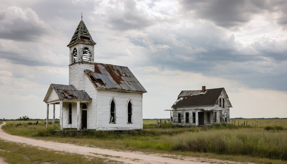
When you arrive at Newport’s location along FM 1288 in Clay County, you’ll find no standing churches or homes—just barren pastureland where foundations have crumbled into rubble or disappeared entirely.
The most substantial remnant is Werner Cemetery, which preserves burial grounds from the settlement era and serves as the primary physical evidence of this community’s existence.
You’ll need to search carefully through overgrown fields to locate any forgotten foundations, as most structures have either collapsed or been reclaimed by the North Texas prairie.
Standing Structures and Ruins
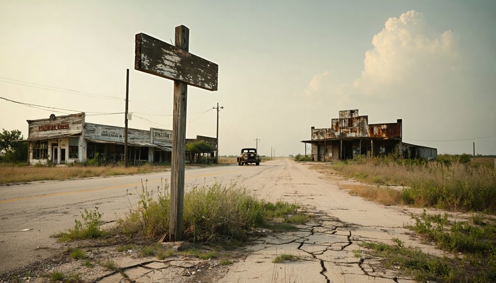
Few structures remain standing in Newport, Texas today, but those that endure tell the story of a community that’s slowly faded from its early 20th-century prominence. You’ll find Roosevelt Street anchors what’s left, featuring:
- A church building standing alongside a fire station and water tower as one of few non-residential survivors
- Roofless commercial ruins on Main Street’s south end, exhibiting advanced structural deterioration
- A faded Royal Crown Cola mural on an old facade, with an adjacent cistern marking past commerce
- Approximately 70 occupied homes scattered among the remnants, housing Newport’s remaining population
The commercial ruins contrast sharply with inhabited residences. What was once a bustling commercial district has transformed into mostly residential streets, leaving only weathered facades and forgotten foundations as evidence of Newport’s vanished prosperity.
Cemetery Markers and Gravesites
Unlike the weathered storefronts along Roosevelt Street, Newport’s cemetery markers have vanished almost entirely from the landscape. The nineteenth-century Black Hope Cemetery once served freed slaves and their descendants until 1939, but developers paved over the unregistered burial ground in 1982. Today, houses stand directly atop up to 60 unmarked memorials near Poppet’s Way.
You’ll find no visible trace of the paupers’ graves that Charlie and Betty Thomas—born into slavery, freed after the Civil War—once occupied before their accidental discovery in 1983. Five miles away in Spanish Cove subdivision, one damaged granite memorial base still stands: Sarah Funghun’s 1904 tombstone, its inscriptions barely visible. These isolated marked graves represent the few physical remnants of communities deliberately erased from official records and living memory.
The Paranormal Legacy: Lawsuits, Legends, and Restless Spirits
The Black Hope Cemetery case transformed from a property dispute into one of Texas’s most notorious haunting legends when the Haney family discovered two coffins while excavating their backyard pool in 1983. Historical records confirmed up to 60 former slaves were buried in unmarked graves before housing development began in 1982.
Residents reported chilling phenomena:
- Appliances and electronics operating independently without power sources
- Apparitions appearing in bedrooms, including faceless figures
- Unexplained illnesses affecting families who disturbed burial sites
- Children’s toys activating with depleted batteries
The Haneys won $142,000 for mental anguish, but a judge reversed the verdict, forcing them into bankruptcy with $50,000 in court costs. The community impact extended beyond one household—a dozen neighbors experienced similar disturbances. The 1992 film *Grave Secrets* immortalized these events, cementing the Black Hope Curse in paranormal lore.
Getting There: Routes and Road Conditions for Each Newport Location

Reaching either Newport requires traversing distinct regions of Texas, with Clay County’s ghost town accessible via US Highway 287 from Wichita Falls—20 miles northeast through flat ranch country—while Walker County’s rural community sits 13 miles northeast of Huntsville along Farm Road 405 through piney woods.
You’ll find paved interstates like I-45 and US 287 in excellent condition year-round, though secondary farm roads deteriorate after rain, particularly FM 405’s two-lane stretch prone to potholes and spring flooding.
From Dallas-Fort Worth, Clay County Newport lies 120 miles northwest (2 hours via I-35W to US 287), whereas Houston drivers reach Walker County’s site in 80 miles northbound on I-45 (1.5 hours under normal traffic).
Clay County Access Routes
Since Newport straddles both Clay and Jack counties, you’ll find Texas State Highway 59 serves as your primary artery into this small community located 24 miles southeast of Henrietta. The route connectivity here relies on straightforward farm-to-market roads intersecting at Newport’s core.
Key travel considerations for Clay County access:
- Highway 59 provides state-maintained reliability as your main thoroughfare spanning the Clay-Jack county line
- Farm to Market Road 2127 functions as your key connector through southeastern Clay County
- FM 1288 intersects FM 2127 at Newport’s center, creating accessible route options
- You’ll navigate typical rural Texas road conditions with active maintenance despite Newport’s disputed ghost town classification
These roads remain functional, serving the 70 residents recorded in this Wichita Falls metropolitan area community.
Walker County River Road
Traversing to Walker County’s River Road requires you to orient from Huntsville, the county seat that anchors your journey into East Texas’s Trinity River bottomlands. Take FM 1791 east toward the Trinity River, where rural road conditions shift from maintained asphalt to unpaved surfaces near Newport’s ghost town remnants.
You’ll navigate a challenging 5-mile dirt stretch demanding high-clearance vehicles, accessible via CR 428’s branching routes.
TxDOT maintains primary FM roads with regular resurfacing, though potholes emerge after storms. Low water crossings present serious flood risk mitigation concerns during wet seasons—plan accordingly.
Traffic remains sparse at under 500 vehicles daily, but cellular service disappears along remote River Road segments. Emergency response stretches 20-30 minutes from Huntsville, making self-sufficiency essential for this backcountry exploration into Texas’s forgotten settlements.
Houston Area Subdivision Directions
From Houston’s northern suburbs, you’ll chart your course toward Newport via US Highway 69, which angles northeast through Montgomery County before entering Walker County’s southern boundaries. Your directions to the subdivision require multi-route awareness, as Newport’s scattered locations demand strategic navigation planning.
Essential Route Markers:
- US 69 Corridor – Primary artery providing southward access from Huntsville, with State Historical Marker south of Rusk pinpointing significant waypoints
- Farm Road 405 – Eastern approach positioned thirteen miles northeast of Huntsville, east of State Highway 19
- Highway 19 Intersection – Critical junction for GPS coordination and directional orientation
- Werner Cemetery – Landmark reference point with precise coordinates available at atlas.thc.state.tx.us
Understanding subdivision infrastructure details proves essential—these ghost town remnants lack modern signage, requiring cemetery markers and historical placements for successful navigation.
Best Times to Visit and What to Bring on Your Ghost Town Tour

Pack comfortable walking shoes for 1-2 hour tours through historic downtown paths. Bring a lantern for nighttime excursions and keep your camera ready for potential apparitions.
Charge devices fully—spirits reportedly drain batteries. Layer weather-appropriate clothing since rain occurs 7-9 days monthly.
Your guide wearing a black US Ghost Adventures t-shirt meets at 32 Touro St, so arrive fifteen minutes early.
Nearby Abandoned Towns to Add to Your Itinerary
Your ghost town adventure doesn’t end at Newport’s city limits—East Texas and the Gulf Coast harbor several abandoned settlements that’ll round out your historical road trip.
A ghost town road trip to Mangum will unveil the remnants of a once-thriving community, inviting you to explore its rich history. As you wander through the quiet streets, you’ll encounter intriguing stories and artifacts that capture the spirit of the past. Don’t forget to take your camera; these abandoned sites provide a unique backdrop for unforgettable photographs.
- Indianola (Matagorda Bay) – Once Texas’s second-largest port welcoming German immigrants, this 1844 settlement was obliterated by hurricanes in 1875 and 1886. Explore weathered foundations, German cemetery markers, and La Salle’s granite monument. Aerial drone photography captures spectacular coastal remnants visible at low tide.
- Belle Plain (Callahan County) – The 1876 county seat features college ruins and cemetery dating to 1878. Family friendly field trips reveal fascinating frontier education history.
- St. Mary (Copano Bay) – This 1850 shipping port retains original 19th-century houses and an accessible cemetery despite storm destruction.
Each site offers unrestricted exploration of Texas’s maritime and settlement heritage.
Preserving History: Photography Tips and Respectful Exploration Guidelines
Ghost town photography demands both technical skill and ethical awareness to capture Newport’s fading heritage without accelerating its decay. You’ll achieve compelling results using wide-angle lenses during golden hour, when natural lighting accentuates weathered textures on the 1880s union church and remaining 1920s-era homes.
Golden hour lighting and wide-angle lenses best capture Newport’s weathered 1880s architecture while minimizing physical impact on fragile historical structures.
When documenting decay, maintain strict non-contact protocols—never touch fragile structures or original artifacts. Stay on designated paths and respect private property boundaries throughout this Clay County settlement.
Your responsibility extends beyond the shutter click. Report observed vandalism to local historical societies and support preservation efforts by sharing educational content without revealing vulnerable site locations. Limit group sizes to minimize impact on protecting heritage structures.
Follow Texas Historical Commission guidelines, carry out all waste, and obtain necessary permissions before photographing. Your images become historical records, so prioritize accuracy and restraint.
Frequently Asked Questions
Are There Any Hotels or Camping Options Near the Newport Ghost Towns?
You’ll find yourself stranded in accommodation limbo near Newport’s ghost towns. Bed and breakfast options and short term rental properties don’t exist there. You’d need to venture toward Terlingua instead, where diverse lodging awaits your independent exploration.
Can I Legally Enter the Abandoned Buildings in These Ghost Towns?
You can’t legally enter Newport’s abandoned buildings without owner permission—Texas trespassing laws apply regardless of abandonment. Historical preservation doesn’t grant public access. Entering risks Class B misdemeanor charges, fines up to $2,000, and potential jail time.
Is Cell Phone Service Available in These Remote Newport Locations?
Cell phone coverage reliability varies considerably in Newport’s remote areas. You’ll find cellular data connectivity limited or nonexistent, as rural Texas locations often lack infrastructure. Check multiple carrier coverage maps beforehand and prepare offline navigation alternatives.
Are the Roads to These Ghost Towns Safe for RVS?
Roads to Newport’s ghost towns are generally RV-accessible via FM 1288 and SH 59, with no major pavement failures reported. However, you’ll find poor signage quality and minimal maintenance on secondary routes, requiring careful pre-trip road conditions checks.
Do I Need Special Permits to Visit These Abandoned Settlements?
You won’t need special permits for Newport’s public areas, but you’ll want to avoid trespassing on marked land. Approximately 95% of Texas ghost towns sit on private property, so always respect private property boundaries and seek owner permission beforehand.


