Planning a ghost town road trip to Rock Bluff, Nebraska means stepping back into 1854, when German pioneer Benedict Spires founded this once-bustling Missouri River settlement. You’ll explore preserved landmarks like the Naomi Institute schoolhouse, rocky bluffs, and an old steamboat landing. Pack sturdy shoes, water, and offline maps — amenities don’t exist out here. Whether you’re coming from Omaha or Lincoln, it’s an easy drive through southeastern Nebraska’s quiet history. There’s much more waiting to discover.
Key Takeaways
- Rock Bluff, founded in 1854, is a ghost town in eastern Cass County, Nebraska, situated along the rocky Missouri River banks.
- From Omaha, drive south on Highway 75 for 25 miles, then head east toward the river, arriving in approximately 45 minutes.
- Key sites include the Naomi Institute schoolhouse, grain elevators, rocky bluffs, and the historic steamboat landing near the riverbanks.
- Pack water, snacks, bug spray, sunscreen, and sturdy footwear, as no amenities exist and terrain can be uneven.
- Download offline maps before visiting, as cell service is unreliable near the Missouri River bluffs surrounding Rock Bluff.
The Rise and Fall of Rock Bluff, Nebraska
Rock Bluff’s story is one of boom and bust — a quintessential American frontier tale.
German pioneer Benedict Spires settled here in 1854, and by 1856, the village had officially organized. Its rocky Missouri River banks made it a natural hub for pioneer settlement, drawing freighters, traders, and steamboat crews fueling a thriving river trade.
Where Is Rock Bluff Located in Nebraska?
Tucked into the eastern edge of Cass County, Nebraska, Rock Bluff sits roughly three miles east of Murray, perched along the dramatic banks of the Missouri River.
More precisely, Rock Bluff geography places it four miles east and one mile north of Murray, within section 9, township 10N, range 14E. The rocky bluffs lining the riverbanks aren’t just scenic — they’re the reason this town earned its name and its Historical Significance as an essential pioneer crossing point.
When you’re planning your route, note that Rock Bluff operates in the UTC-6 Central Standard Time zone, shifting to UTC-5 during summer.
A nearby steamboat landing and an old coal mine once defined this stretch of river, reminders of the commerce that briefly made Rock Bluff thrive.
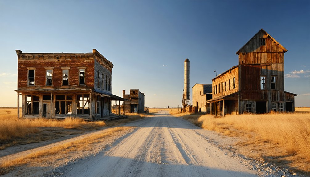
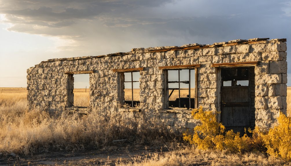
What’s Actually Left to See at Rock Bluff Today?
What remains of Rock Bluff today is modest but genuinely worth seeking out. You’ll find historic remnants scattered across the landscape, each carrying whispers of local legends from Nebraska’s frontier era.
Here’s what you can explore:
- Naomi Institute schoolhouse – preserved by the Cass County Historical Society, featuring original limestone foundation and red brick construction
- Grain elevators – substantial structures still standing near the Missouri River banks
- Rocky bluffs – the natural formation that gave the town its name remains unchanged
- Steamboat landing site – the historic riverside access point where commerce once thrived
- Former townsite – walkable grounds where stores, saloons, and community buildings once stood
Pack your curiosity, bring a camera, and give yourself time to absorb what silence communicates better than any museum exhibit could.
How Do You Get to Rock Bluff From Major Nebraska Cities?
Getting to Rock Bluff requires a bit of intentional navigation, but the drive itself rewards you with some of Nebraska’s most scenic river country.
Pull up your directions map before leaving, because signage gets sparse near the Missouri River bluffs.
From Omaha, head south on Highway 75 approximately 25 miles into Cass County, then cut east toward the river. The drive runs roughly 45 minutes.
From Lincoln, travel northeast on Highway 1, connecting to Highway 75 north of Plattsmouth — expect about an hour on the road.
Rock Bluff sits three miles east of Murray, tucked along the river’s rocky banks.
Build this stop into a broader road trip exploring southeastern Nebraska’s ghost towns, river landscapes, and limestone bluffs for the most rewarding experience.
What Should You Bring for a Rock Bluff Site Visit?
Once you’ve mapped your route to Rock Bluff, packing smart makes the difference between a memorable visit and an uncomfortable one.
The site’s riverbank terrain and limestone ruins demand essential gear that keeps you mobile and prepared.
Here’s what to pack before you go:
- Sturdy footwear for uneven rocky bluffs and overgrown terrain
- Water and snacks since no amenities exist at this ghost town
- Camera or smartphone to document the grain elevators and Naomi Institute schoolhouse
- Bug spray and sunscreen for exposed riverbank exploration
- Navigation tools including offline maps, since cell service is unreliable near the Missouri River
Traveling light but smart lets you explore freely without limitations holding you back from discovering Rock Bluff’s remarkable frontier history.
What Other Historical Sites Are Near Rock Bluff?
Rock Bluff doesn’t stand alone in Cass County‘s rich frontier landscape — several compelling historical sites surround it within easy driving distance.
Plattsmouth, just a short drive north, offers local museums documenting the county’s fierce competition for governmental influence and early river commerce. The town’s historic downtown preserves genuine 19th-century architecture worth exploring on foot.
Murray sits three miles west, connecting you to rural Nebraska’s agricultural heritage.
Cass County Historical Society maintains historical landmarks throughout the region, including the Naomi Institute schoolhouse you’ve already seen at Rock Bluff.
Nebraska City, farther south along the Missouri River, anchors another significant frontier-era stop with its own compelling story.
Combining these destinations into one dedicated day trip gives you a complete picture of Nebraska’s pioneering spirit along the river corridor.
Frequently Asked Questions
Was Rock Bluff Ever Considered as Nebraska’s State Capital?
Rock Bluff wasn’t considered Nebraska’s state capital, but you’ll find its historical significance undeniable. It competed for Cass County’s seat, shaped statehood votes, and thrived as a river hub before fading into ghost town history.
Can You Legally Metal Detect or Artifact Hunt at Rock Bluff?
The knowledge base doesn’t cover metal detecting regulations for Rock Bluff specifically. You’ll want to research Nebraska’s artifact hunting ethics laws and local ordinances before detecting, as rules vary by land ownership and historical site designations.
Are There Guided Ghost Town Tours Specifically Offered for Rock Bluff?
Like tumbleweeds drifting through forgotten streets, Rock Bluff’s ghost town history lacks dedicated guided tours. You’ll need to explore independently, though the Cass County Historical Society may offer insights into this hauntingly abandoned Nebraska treasure.
Is Rock Bluff Privately Owned or Accessible as Public Land?
Rock Bluff’s land ownership isn’t fully public, but you can explore its ghost town history through the Cass County Historical Society, which actively preserves the Naomi Institute schoolhouse, welcoming history enthusiasts who crave authentic, unrestricted connections with Nebraska’s frontier past.
What Is the Best Time of Year to Visit Rock Bluff?
Spring and fall offer the best season to explore Rock Bluff. You’ll enjoy mild weather conditions, making it easier to wander the limestone ruins, photograph grain elevators, and soak in the Missouri River’s haunting, historic atmosphere.
References
- https://kids.kiddle.co/Rock_Bluff
- https://hcsghosttowns.wordpress.com/2015/10/07/rock-bluffs-iowa/
- https://history.nebraska.gov/wp-content/uploads/2017/04/doc_Rock-Bluff-City-Cass-County-RG307.pdf
- https://naturalatlas.com/bluffs/rock-1468718
- https://www.ghosttowns.com/states/ne/rockbluff(occasionallyrockbluffs).html
- https://npgallery.nps.gov/GetAsset/137d969c-1828-4164-a496-75d837e0a580


