To visit Rockville, Iowa’s ghost town, head west off Highway 136 a few miles south of Dyersville toward the North Fork Maquoketa River in Delaware County. You’ll find a hauntingly quiet landscape where an abandoned stone grist mill and a weathered cemetery filled with Civil War graves tell the story of a once-thriving 1845 stagecoach town. There’s far more to this forgotten place than you’d expect, and every crumbling corner reveals another piece of Iowa’s hidden past.
Key Takeaways
- Rockville, Iowa, is located west of Highway 136, near the North Fork Maquoketa River, on the Delaware and Dubuque County border.
- Begin your trip on Highway 136 south of Dyersville, turning west toward the river to reach the ghost town.
- Explore the abandoned stone grist mill along the riverbank, a striking example of 19th-century settler craftsmanship and self-sufficiency.
- Visit the historic cemetery containing graves from the 1840s, including Civil War veterans, reflecting Rockville’s earliest settler stories.
- Extend your road trip to nearby Buckhorn, which features a rare standing creamery and additional ghost town exploration opportunities.
What Is Rockville, Iowa’s Ghost Town Story?
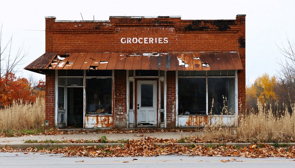
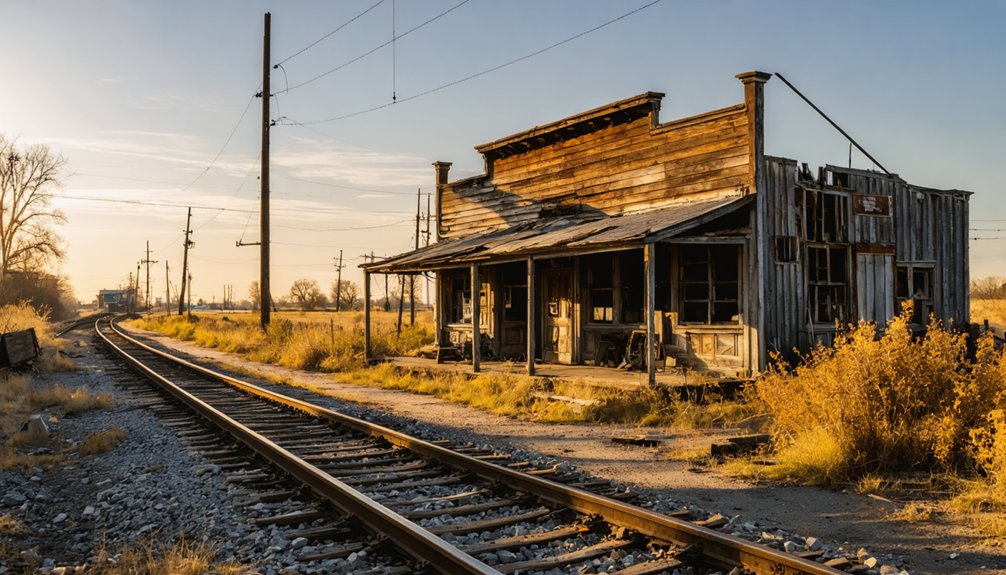
Tucked away in Delaware County, Iowa, Rockville was once a thriving frontier settlement founded in 1845, making it one of the oldest towns in the region. It served as a crucial stagecoach stop, bustling with a hotel, stores, a sawmill, a grist mill, and a blacksmith shop.
Its historical significance stems from its role connecting early settlers traveling from Dubuque into the frontier.
But Rockville’s story took a dramatic turn when the railroad bypassed the town, rerouting through nearby Dyersville instead. Residents followed opportunity, abandoning Rockville by the 1930s.
Today, ghost town legends surround its eerie cemetery and crumbling mill ruins along the North Fork Maquoketa River. You’re stepping into a forgotten world when you visit, where history whispers through weathered headstones and mossy stone walls.
Where Exactly Is Rockville Located in Delaware County?
Rockville sits a couple of miles west of Highway 136, nestled along the banks of the North Fork Maquoketa River on the border of Delaware and Dubuque Counties.
You’ll find it tucked south of Dyersville and north of Worthington, a quiet stretch of Iowa countryside that hides remarkable historical significance beneath its overgrown stillness.
Rockville’s geography placed it perfectly for 19th-century settlers pushing west from Dubuque. That strategic position made it a natural stagecoach stop, drawing travelers who needed supplies, shelter, and services.
Rockville’s position made it a natural crossroads, drawing westbound settlers in need of supplies, shelter, and rest.
The river provided power for the mills that fueled the town’s early economy.
Today, that same geography rewards explorers willing to leave the highway. Follow the road west, and you’ll discover a landscape that hasn’t forgotten the town it once supported.
How Did the Railroad Kill Rockville?
When the railroad bypassed Rockville in favor of Dyersville, it didn’t just redirect trains — it redirected the town’s entire future. The railroad impact was immediate and devastating. Without rail access, businesses lost their competitive edge, and residents began drifting toward Dubuque and Dyersville, where opportunity followed the tracks.
The post office closed in 1898, an early warning sign of the ghost town decline already underway. By 1930, Rockville was fundamentally gone.
What had once been a thriving stagecoach stop — complete with hotels, stores, and mills — couldn’t survive without modern infrastructure.
You’re now standing where ambition once ran deep. The railroad didn’t fire a single shot, but it effectively erased a community that early Iowa settlers had worked hard to build.
Why Did Rockville Vanish While Dyersville Survived?
What separates a surviving town from a ghost town often comes down to a single decision made by railroad planners miles away. Dyersville won that decision. Rockville didn’t. When the railroad routed through Dyersville, commerce, population, and opportunity followed those tracks north. Rockville, stripped of economic momentum, couldn’t compete.
You’re standing at the crossroads of two very different fates when you visit here. Dyersville grew into a regional center while Rockville quietly surrendered, its dying communities fading into memory by 1930.
What remains carries enormous historical significance — a cemetery with Civil War-era graves and a crumbling stone mill tell stories no thriving town preserves this honestly. Rockville’s collapse isn’t a tragedy to mourn; it’s a lesson worth driving out to witness firsthand.
Rockville Cemetery and Its Civil War Graves
When you step into Rockville Cemetery, you’re walking among graves that date back to the 1840s, with some headstones honoring soldiers who fought in the Civil War.
The weathered markers, worn by over a century of Iowa winters, still stand quietly in the wooded grounds, telling the stories of the town’s earliest settlers.
You’ll find the tree-covered terrain adds an eerie atmosphere that makes the experience feel both haunting and historically unforgettable.
Cemetery’s Civil War History
Tucked among the trees of what was once a thriving Iowa settlement, Rockville Cemetery holds some of the region’s oldest graves, with headstones dating back to the 1840s.
You’ll find markers from Civil War veterans here, adding profound historical significance to this quiet ghost town. These aren’t just stones in the ground — they’re reflections of real people who built something meaningful in the Iowa wilderness.
As you walk through during your cemetery exploration, you’re stepping through layers of American history, from frontier settlement to wartime sacrifice. The weathered inscriptions tell stories no textbook captures quite so powerfully.
Rockville’s cemetery transforms what might seem like a simple road trip detour into a genuinely moving encounter with the past that you won’t easily forget.
Weathered Headstones And Markers
Among those Civil War markers and pioneer graves, the physical headstones themselves tell a story that’s easy to overlook if you’re not paying attention. Run your fingers across the weathered markers, and you’ll feel decades of Iowa winters etched into the stone. Some inscriptions have faded nearly beyond recognition, yet their historical significance remains undeniable.
These aren’t museum pieces behind glass — they’re raw, unfiltered connections to people who carved a life out of frontier Iowa in the 1840s. You’ll spot varying stone types, shapes, and carving styles reflecting different eras and economic circumstances of Rockville’s settlers.
A few markers lean at odd angles, slowly surrendering to the earth. That quiet deterioration makes the cemetery feel less like a tourist stop and more like genuine, forgotten history.
Exploring The Wooded Grounds
Stepping into Rockville Cemetery feels like crossing a threshold between the present and the frontier Iowa of the 1840s. Towering trees form a natural canopy overhead, and wooded trails wind between headstones that lean with age.
You’ll notice the quiet immediately — no traffic, no crowds, just rustling leaves and decades of history pressing in around you.
As you explore, the historical significance of this ground becomes undeniable. Graves dating to the Civil War era remind you that real families built lives here, fought wars, and were buried far from any major city.
Navigate carefully through the underbrush, reading inscriptions where you can. The cemetery sits mostly forgotten, making your visit feel genuinely exploratory — like discovering something the modern world left behind without ceremony.
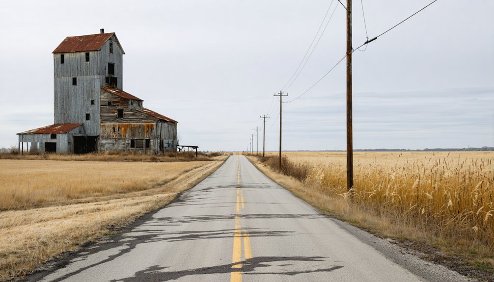
The Abandoned Stone Grist Mill on the Maquoketa River
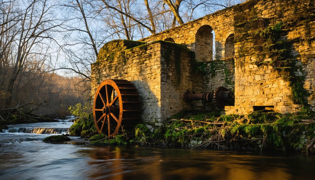
Along the banks of the North Fork Maquoketa River, the abandoned stone grist mill stands as Rockville’s most tangible link to its 19th-century past.
You’ll immediately notice the grist mill architecture — solid, deliberately constructed stonework that reveals how seriously early settlers took their self-sufficiency. This structure once powered the local economy, grinding grain for surrounding farms and drawing travelers along the stage coach route.
Studying the river history here, you can almost picture loaded wagons lining up outside, farmers exchanging news while waiting their turn.
Today, the mill’s weathered walls invite exploration and historical photography. It’s a rare, authentic remnant that most ghost towns can’t offer.
Bring your camera, respect the site, and take your time absorbing what this crumbling structure genuinely represents — resilience, ambition, and eventual abandonment.
How to Drive to Rockville From Highway 136
To find Rockville, you’ll start on Highway 136, positioned a few miles south of Dyersville.
From there, you’ll turn west, following the road as it winds toward the North Fork Maquoketa River.
Before long, you’ll arrive at what remains of this once-thriving stage coach stop, where only a crumbling mill and a shadowy cemetery mark the town’s forgotten footprint.
Starting From Highway 136
If you’re heading to Rockville from Highway 136, you’ll want to drive a few miles south of Dyersville before turning west. The North Fork Maquoketa River will guide you toward this forgotten ghost town, tucked quietly into Delaware County’s wooded landscape.
Watch for the turnoff heading west from the highway, and you’ll find yourself leaving the modern world behind almost immediately. The road feels appropriately remote for a destination carrying this much historical significance.
Rockville’s story stretches back to 1845, and the isolation you’ll experience driving in reflects exactly why the town eventually faded once the railroad bypassed it.
Keep your eyes open as you approach — the treeline hides the old cemetery and mill ruins that make this detour genuinely worth your time.
Turning West Toward Rockville
Once you’ve spotted that westward turnoff from Highway 136, you’re committing to a road that feels like it belongs to another century. This short drive delivers you straight into ghost town exploration territory, where Rockville’s historical significance still echoes through the landscape.
Watch for these landmarks as you head west:
- The North Fork Maquoketa River running parallel to your route
- Dense tree lines marking the old settlement boundaries
- The abandoned stone grist mill appearing near the riverbank
- A wooded cemetery tucked back from the road
You’re traveling ground once covered by stagecoach wheels carrying settlers from Dubuque.
Nobody’s rushing you here. Take it slow, absorb the quiet, and let Rockville’s forgotten story start revealing itself before you even step out of the car.
Arriving At Ghost Town
Pulling off Highway 136 a few miles south of Dyersville, you’ll head west down a quiet county road that cuts through Delaware County‘s rural landscape.
The drive feels deceptively ordinary until the North Fork Maquoketa River comes into view, signaling you’re approaching something forgotten by time.
Rockville’s ghost town sits near the Delaware and Dubuque County border, tucked along the river’s edge. You won’t find signs announcing its historical significance — this place rewards those willing to seek it out.
Watch for the tree line where the old cemetery hides among the woods, and follow the riverbank to locate the abandoned stone grist mill.
Park where the road allows, step outside, and let the silence remind you that you’ve genuinely discovered somewhere most people never bother finding.
Extend Your Rockville Ghost Town Visit by Adding Buckhorn
After exploring Rockville’s cemetery and crumbling mill, you can easily extend your ghost town adventure by heading to nearby Buckhorn, another forgotten Iowa settlement worth adding to your itinerary.
Buckhorn attractions include a rare standing creamery, making it a standout among ghost town legends in the region.
Here’s what to prioritize on your visit:
- Photograph the creamery — one of the few intact structures among Iowa’s ghost towns.
- Research local ghost town legends — Buckhorn carries its own fascinating stories of decline.
- Combine your geocaching stops — both towns offer unique cache locations.
- Trace the Iowa ghost town trail — connecting Rockville and Buckhorn creates a rewarding historical route.
Together, both towns deliver an unforgettable, freedom-fueled journey through Iowa’s forgotten past.
Frequently Asked Questions
Is There a Geocache Hidden at the Rockville Ghost Town Location?
Yes, you’ll find geocache site GC12D7A hidden at Rockville’s ghost town location! Combine your geocaching tips adventure with ghost town history, exploring the eerie cemetery and abandoned mill along the North Fork Maquoketa River.
What County Border Does Rockville Sit On?
You’ll find Rockville sitting on the border of Delaware and Dubuque Counties, where Rockville history blends rich ghost town legends into a hauntingly fascinating destination that’s yours to freely explore and discover.
Are There Any Night Visits Allowed at Rockville Cemetery?
Imagine sneaking in after dark like an adventurer — don’t. There’s no confirmed nighttime exploration policy, so respect cemetery etiquette and visit during daylight hours. You’ll still feel Rockville Cemetery’s eerie, historic atmosphere without risking trespassing.
What Other Ghost Towns Can Be Combined With a Rockville Trip?
You can combine Rockville with Buckhorn, where you’ll find abandoned buildings and a standing creamery steeped in local legends. Don’t miss the Buddy Holly crash site—it’s an unforgettable, freedom-fueled ghost town road trip!
When Did Rockville’s Post Office Officially Close Down?
After 53 years of operation, Rockville’s post office history ended in 1898. You’ll find this closure marks the ghost town significance — it’s when the community’s lifeline severed, signaling Rockville’s inevitable fade into abandonment.
References
- https://www.youtube.com/watch?v=IJXffTEZN_g
- https://www.youtube.com/watch?v=1J0Qx64ZrwI
- https://www.geocaching.com/geocache/GC12D7A
- https://www.onlyinyourstate.com/experiences/iowa/ia-ghost-town