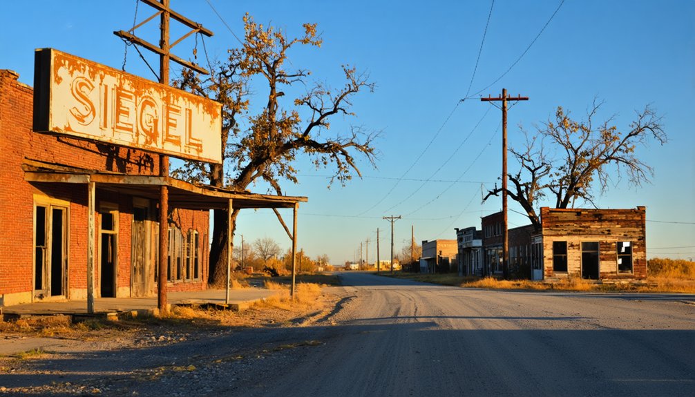
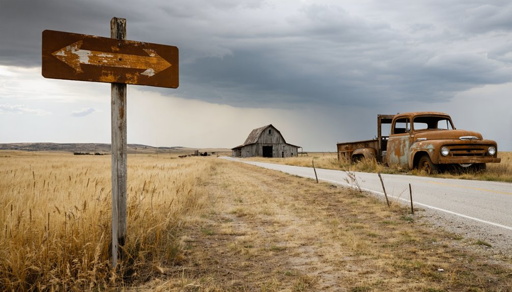
You’ll find Siegel one mile west of U.S. Route 63 in Mills County, where St. John’s United Church of Christ stands as the lone survivor of an 1889 German settlement. Drive north from Waverly for 10 miles, then navigate gravel roads—spring’s mud and winter’s 30 inches of snow make timing pivotal. Pack all supplies since there’s nothing for miles around. The church against endless farmland creates stunning photography, especially at dawn, and there’s much more to discover about this vanished prairie community.
Key Takeaways
- Siegel is located 1 mile west of U.S. Route 63 along Kildeer Avenue at coordinates 42°49′44″N 92°21′25″W.
- Visit in spring or fall for optimal weather; avoid winter’s 30 inches of snow and summer’s thunderstorms.
- Only St. John’s United Church of Christ remains intact; most structures have crumbled to foundation stones.
- Bring all supplies as no modern amenities exist for miles; gravel roads require careful navigation.
- Photography highlights include the church at dawn, cemetery aerials, and wide-angle shots of farmland horizons.
The History Behind Siegel’s Rise and Fall
The windswept prairies of Mills County, Iowa, watched Siegel emerge from nothing in 1889—just another hopeful dot on the map during America’s great rural expansion. You’ll find its rise and factors intertwined with promise: fertile soil drew families chasing agricultural prosperity, while nearby transportation routes meant farmers could actually get their crops to market.
The town built itself up through the early 1900s—stores, homes, a post office serving neighbors scattered across the countryside.
But here’s what you need to know: by the 1930s, everything shifted. Agriculture mechanized, markets consolidated, and those same transportation advantages that built Siegel started favoring bigger towns. By the 1940s, residents had vanished, leaving behind empty buildings that wouldn’t last another generation.
Getting There: Routes and Road Conditions
Finding Siegel today requires traversing Bremer County’s patchwork of rural roads—not the Mills County location where the town’s history unfolded. You’ll head to coordinates 42°49′44″N 92°21′25″W, one mile west of U.S. Route 63 along Kildeer Avenue. Start from Waverly, ten miles south, and follow the federal highway north before turning onto the county road system.
Gravel road conditions vary greatly here. That final mile-long stretch from U.S. 63 demands attention in standard vehicles, though it’s generally passable.
Seasonal weather impacts transform these routes—spring thaws create muddy challenges, while winter snow can make unpaved sections treacherous. Summer and fall offer excellent driving conditions.
Your GPS coordinates will guide you between 160th and 150th Streets, where Douglas Township’s grid layout makes navigation straightforward once you’ve conquered that initial gravel approach.
What Remains at the Siegel Site Today
When you arrive at Siegel, you’ll find St. John’s United Church of Christ standing alone against the Iowa sky—the only intact building left from the original settlement.
Beyond the church, crumbled foundation stones and weathered concrete blocks peek through tall prairie grass, marking where homes and businesses once lined dirt streets. Your camera will capture haunting contrasts: the church’s white clapboard siding still crisp and maintained, while nature reclaims everything else through tangled vines and wildflowers sprouting from forgotten cellar holes.
Visible Building Foundations
Pulling up to Siegel today, you’ll find yourself staring at fundamentally one structure: the weathered but intact St. John’s United Church of Christ. Unlike other Iowa ghost towns where you’ll trace multiple foundations across the settlement layout, Siegel’s foundations comparison reveals stark emptiness. The creamery, general store, and post office vanished without leaving discernible bases behind.
What you’ll encounter:
- Church foundation at 42°49′44″N 92°21′25″W – the sole structural remnant from the 1889 German settlement
- Barren ground where businesses stood – no visible creamery or store foundations despite operating until the 1940s
- Scattered elements only – nothing substantial beyond the church’s enduring base
It’s a minimalist ghost town experience, perfect for those seeking unobstructed horizon views rather than extensive ruins.
Scattered Structural Remnants
The single church structure dominates Siegel’s landscape in a way that tells its own story—standing alone where a dozen buildings once clustered together along what residents called Main Street. You’ll find no non obvious structural remnants where the creamery processed milk or the general store sold provisions. The earth has reclaimed everything except St. John’s United Church of Christ, which rises from surrounding farmland like a weathered sentinel.
Unlike ghost towns with crumbling foundations marking forgotten businesses, Siegel offers virtually nothing beyond that church. No lingering architectural artifacts hint at the post office Frederick Schultz, Jr., once managed, or the commercial buildings that vanished in the 1940s. The site’s absorbed completely into agricultural use, leaving imagination to reconstruct what German settlers built here.
Photography Opportunities Available
Standing before St. John’s United Church of Christ, you’ll discover exceptional scenic qualities for capturing Iowa’s ghost town essence. The solitary structure rises against endless farmland, offering unobstructed compositions along quiet Kildeer Avenue where you can position your tripod without interference.
Prime shooting opportunities include:
- Wide-angle isolation shots framing the church against Douglas Township’s flat horizon
- Seasonal variations featuring spring corn shoots, golden autumn fields, or winter’s stark whiteness
- Golden hour silhouettes when low sun illuminates weathered walls between 160th and 150th Streets
You’re free to explore the coordinates 42°49′44″N 92°21′25″W without traversing crowds or restrictions. Check for historical markers near the church—they’ll add narrative depth to your frames while documenting Siegel’s final architectural survivor.
Best Times to Visit This Iowa Ghost Town
When planning your visit to Siegel, spring emerges as the sweet spot for ghost town exploration. You’ll find mild 50-70°F temperatures perfect for wandering among remnants without battling summer’s oppressive humidity or winter’s brutal snowdrifts. The wildflowers blooming along Kildeer Avenue create stunning backdrops for capturing preserved artifacts through your lens.
Spring delivers ideal 50-70°F weather for exploring Siegel’s ruins, with wildflowers along Kildeer Avenue framing perfect shots of this forgotten settlement.
Fall offers another compelling window—those vibrant mid-October colors transform seasonal photography challenges into opportunities, though you’ll need to arrive by afternoon before darkness swallows the landscape.
Summer’s extended daylight seems ideal, but thunderstorms roll in unpredictably, and dense vegetation obscures ruins.
Skip winter unless you’re hardcore; 30 inches of snow buries pathways to the old creamery site. Pack your own supplies year-round—there’s nothing modern for miles around this forgotten settlement west of Route 63.
Photography Opportunities Among the Ruins
Once you’ve picked your season and arrived at Siegel, your camera becomes your passport to preserving this settlement’s fading memories. St. John’s United Church of Christ showcases unique architectural features reflecting German settler heritage, while preservation challenges become evident in the decaying creamery structures from the 1940s.
Three Essential Shots You’ll Want:
- Dawn at the Church – Golden hour light transforms weathered wood siding into textured gold, creating dramatic contrasts perfect for black-and-white conversions.
- Creamery Details – Macro shots of rusted metal and splintered wood reveal nature’s reclamation process in stunning decay patterns.
- Cemetery Aerials – Drone photography captures Civil War-era headstones scattered across overgrown grounds, telling stories from the 1840s through atmospheric bird’s-eye compositions.
Wide-angle lenses excel along Kildeer Avenue, framing the church against endless Iowa farmland.
Rockville: A Nearby Ghost Town Worth Exploring
Just fifteen miles from Siegel, Rockville offers a compelling counterpoint to your ghost town exploration—where Siegel faded gradually, Rockville died abruptly when the railroad chose Dyersville instead.
Founded in 1845, Rockville thrived through early commerce and industry including sawmills, gristmills, and blacksmith shops. Notable residents like founder Oliver A. Olmstead and merchant Charles W. Hobbs built a prosperous stagecoach stop before the 1898 post office closure sealed the town’s fate.
You’ll find the abandoned stone grist mill along the Maquoketa River’s banks—bring your camera for dramatic riverside shots. Rockville Cemetery preserves the settlement’s soul with headstones dating to the 1840s, including Civil War veterans. Navigate the hilly gravel roads carefully; this untamed landscape rewards those seeking authentic frontier remnants without tourist crowds or restrictions.
The Story of Buxton’s Booming Coal Mining Past
You’ll find Buxton’s story remarkable—by 1900, it had exploded into the largest coal mining town west of the Mississippi, with 5,000 residents and mines producing over a million tons annually. The Consolidation Coal Company kept 1,800 men working steady five-day weeks at wages reaching $100 in gold and silver, thanks to the Chicago & North Western Railroad buying every ounce of coal they extracted.
But after fires ravaged the town in 1916 and the mines ran dry, Buxton’s population crashed from thousands to just 400 by 1919, and the last shovel hit rock in 1927.
Peak Population and Growth
Between 1900 and 1910, Buxton exploded from a newly established coal camp into what locals proudly called “the black man’s town“—the largest coal mining operation west of the Mississippi and the nation’s biggest unincorporated city.
You’d have witnessed remarkable population density as residents flooded in for economic opportunities:
- 1905 milestone: 5,000 residents with 2,700 blacks (55%) and 1,991 whites living without segregation
- 1910 peak: 8,000-10,000 residents crowding company houses along integrated blocks
- Industrial boom: 1,800 miners earning $50-$100 weekly in gold and silver, fueling prosperity
Monroe County became Iowa’s coal kingpin, producing over 1.1 million tons in 1906. Mine No. 18’s record-breaking 3,774 tons hoisted in eight hours proved Buxton’s dominance during WWI’s coal rush.
Mining Operations and Decline
While Buxton’s integrated streets buzzed with prosperity, the town’s fate was already sealed beneath its feet—black gold that wouldn’t last forever.
You’d have witnessed extraordinary productivity here. Mine No. 18 set records in 1913, hoisting 3,774 tons in eight hours with cutting-edge equipment. The railroad bought every lump, keeping 1,800 miners working five days weekly for gold and silver wages.
But freedom from economic uncertainty proved fleeting. By 1914, seams started running dry. Labor challenges persisted despite unionization, and broader industry shifts killed coal demand. Devastating fires in 1916 torched entire blocks, convincing families to chase opportunities elsewhere.
The Consolidation Coal Company abandoned ship in 1923, relocating to Haydock. Mine No. 18 shut down in 1927. By 1932, silence replaced the rhythmic clang of pickaxes forever.
Respecting Property Lines and Safety Precautions
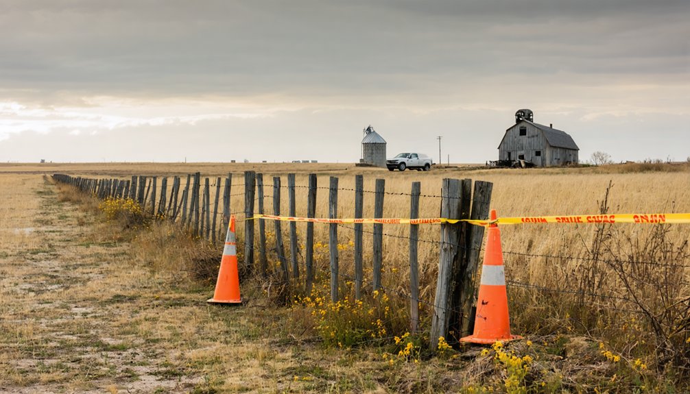
Before setting out for Siegel, you need to understand that this ghost town’s remnants likely sit on private property. Cedar County’s GIS maps reveal ownership boundaries—study them before your journey. Obtaining landowner permissions isn’t just courteous; it’s legally required under Iowa trespassing laws. Contact the county auditor’s office for current owner information.
Respect property rights: Cedar County GIS maps and landowner permission are essential before exploring Siegel’s abandoned sites.
Navigating public vs private lands demands careful preparation:
- Check plat books through Cedar County’s GIS system to identify exact property lines from Taylor Township’s historical records
- Secure written permission from landowners before crossing any boundaries—abandoned doesn’t mean unowned
- Pack safety essentials: first-aid kit, water, GPS device, and weather-appropriate gear for Iowa’s unpredictable conditions
Collapsed structures and overgrown terrain create real hazards. Travel with companions, share your itinerary, and respect the land you’re privileged to explore.
Creating Your Multi-Stop Ghost Town Itinerary
Once you’ve mapped property boundaries and secured permissions, expand your adventure beyond Siegel to capture Iowa’s vanishing history in a single journey. Start at Siegel’s St. John’s Church, then head south to Rockville’s stagecoach ruins in Delaware County. Each stop reveals distinct community demographics—German settlers at Siegel, diverse pioneers elsewhere.
You’ll witness how agricultural history shaped these settlements’ rise and fall, from Siegel’s 1889 creamery operations to Buckhorn’s inn serving frontier travelers.
Plot your route strategically: Bremer County to Delaware, Jackson, then swing west toward Adair County’s Stanzel before looping east to Sunbury or Stiles. Pack camping gear, download offline maps, and budget two days minimum. These forgotten coordinates aren’t tourist traps—they’re authentic fragments of pioneer Iowa waiting for you to document before they vanish completely.
Essential Supplies for Remote Rural Exploration
When you’re exploring abandoned places like Siegel where cell towers are scarce and the nearest help might be twenty miles away, your navigation and communication tools become lifelines rather than conveniences. I learned this the hard way during a Kansas ghost town trip when my phone died and I’d left my paper map in the car—what should’ve been a thirty-minute detour turned into three hours of backtracking dirt roads.
Pack a waterproof compass, detailed topographic maps of the area, and a headlamp with fresh batteries, because GPS satellites won’t help you when you’re stumbling through a collapsed barn at dusk with 10% phone battery.
Getting lost on unmarked gravel roads thirty miles from the nearest town concentrates the mind wonderfully on navigation basics. You’ll need layered redundancy—digital GPS units like Garmin eTrex for waypoint marking, paired with baseplate compass navigation techniques when batteries die. Download offline maps through Gaia GPS before cell service vanishes, and carry printed USGS topographic maps showing Siegel’s 1960s layout.
Your navigation toolkit should include:
- Handheld GPS unit capabilities with pre-loaded historical maps and marked waypoints for ghost town coordinates
- Lensatic compass paired with current topographic maps—your failsafe when technology quits
- Printed county gazetteer showing every forgotten crossroad and abandoned homestead trail
Master compass navigation techniques before departure. Freedom means self-reliance, not hoping your phone works.
Safety and Emergency Gear
Your best navigation gear won’t save you when a rusty beam crashes through a rotted ceiling or you’re bleeding from a nail puncture three hours from the nearest clinic. Pack personal medical supplies including bandages, antiseptic wipes, and pain medication—I’ve watched explorers learn this lesson the hard way.
Proper safety attire means sturdy boots with thick soles, a hard hat for those crumbling structures, and heavy-duty gloves before touching anything. Throw in a respirator for mold-filled rooms, emergency blankets, and water purification tablets.
Siegel’s abandoned buildings hide tetanus traps in every shadow. Your freedom to explore depends on preparing for the worst while hoping for the best. A multi-tool and duct tape have rescued more adventures than any GPS.
Frequently Asked Questions
Are There Any Restaurants or Gas Stations Near Siegel?
No, Siegel’s ghost town status means zero local amenities exist. You’ll find nearest dining options like Kava House Cafe and closest fuel stations around Cedar Rapids or Swisher, roughly 20-30 miles away—so fuel up before your adventure begins.
Can I Camp Overnight at the Siegel Ghost Town Site?
You can’t camp overnight at Siegel’s ghost town site—there aren’t amenities for overnight stays or designated camping areas. Check nearby Iowa county parks for overnight camping regulations, where you’ll find proper facilities and registration options for your adventure.
Are Guided Tours Available for Iowa Ghost Town Exploration?
You’ll find self-guided tours through Hamilton County’s ghost towns, not formal guided experiences. Local history museums like Carroll County’s offer organized ghost town adventures, but you’re free to explore independently, discovering forgotten stories at your own pace.
What Cell Phone Coverage Exists in the Siegel Area?
You’ll find minimal cellular network availability in Siegel’s remote location, with data coverage reliability extremely limited. Test multiple carriers beforehand, download offline maps, and embrace the digital detox—this abandoned town offers genuine escape from constant connectivity.
Are There Any Ghost Stories or Paranormal Reports From Siegel?
Silent Siegel’s secrets remain scarce—you won’t find documented paranormal reports here. However, locals whisper about haunted hotel ruins and mysterious disappearances from Iowa’s ghost town era. You’re free to explore and create your own spine-tingling discoveries.