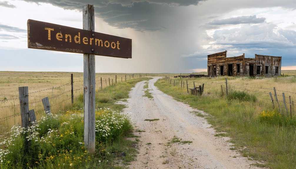
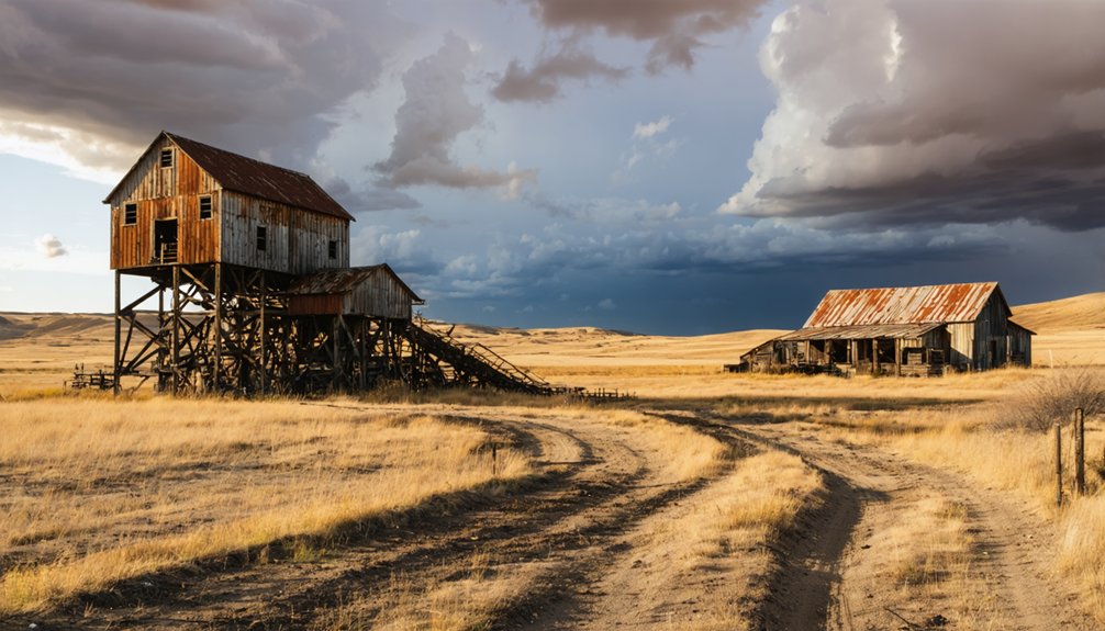
You’ll need a high-clearance vehicle to navigate the primitive mountain tracks leading to Tenderfoot’s weathered wooden buildings and remarkably intact root cellar, perched at 5,686 feet in the Custer Mining District. Pack three days’ water, emergency supplies, and GPS with topographic maps—this remote site sits on private property with restricted access. The journey through ponderosa forests reveals crumbling compressor foundations, ore processing equipment, and remnants of the 300-foot shaft where Richard Pierce’s 1876 tin discovery sparked boom-and-bust dreams that collapsed into scandal by 1893, leaving only foundations and stories waiting beneath the pines.
Key Takeaways
- Tenderfoot sits at 5,686 feet elevation in Pennington and Custer Counties, requiring high-clearance vehicles on primitive mountain roads.
- The site features weathered wooden buildings, an intact root cellar, and remnants of a 300-foot vertical tin mining shaft.
- Access is challenging due to private property ownership; use Berne USGS topographic maps and reliable GPS for navigation.
- Pack three days’ water, emergency supplies, layered clothing, and vehicle recovery gear for remote backcountry conditions.
- Historic tin mining operations by Harney Peak Company collapsed in 1893 after fraud scandals, leaving processing equipment and foundations.
Getting to Tenderfoot: Routes and Road Conditions
Nestled in the rugged terrain where Pennington and Custer Counties converge, Tenderfoot reveals itself only to those willing to navigate the Black Hills’ challenging backcountry roads. You’ll need proper driving route logistics before venturing toward coordinates 43.838039°N, -103.6404727°W, where this historical settlement sits at 5,686 feet elevation.
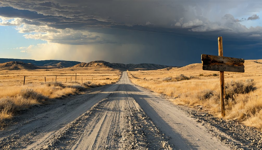
Road conditions demand attention—these aren’t maintained highways but primitive mountain tracks threading through Custer Mining District territory. Reference the Berne USGS topographic map for terrain assessment, and load waypoints into your GPS using ExpertGPS downloads.
The approach from Custer town offers the most reliable access, though “reliable” here means passable, not comfortable. High-clearance vehicles prove essential when tackling the elevation changes between Tenderfoot Creek’s 5,361 feet and the ghost town’s loftier perch.
What Remains at the Tenderfoot Mining Camp Today
You’ll find scant evidence of Tenderfoot’s mining past scattered across this remote hillside at 6,001 feet. The site sits on private property, making access difficult and leaving most physical traces—if any mining equipment, building foundations, or shaft remnants survive—hidden from casual exploration.
What remains of this 1890s prospect exists largely in historical records rather than visible ruins, a ghost town more phantom than substance.
Physical Traces and Structures
Though time and the elements have claimed most of Tenderfoot’s original structures, scattered remnants still mark where miners once carved out their brief existence in these hills. You’ll discover the Tenderfoot Creek Cabin standing among a handful of preserved shelters that once served this wilderness community.
A short trail brings you to what remains:
- Weathered wooden buildings with exposed cabin interiors, their walls covered in decades of graffiti
- A remarkably intact root cellar—the most resilient survivor from the mining era
- Collapsed community buildings surrounded by muddy foundations and rusted metal fragments
Ponderosa pines now reclaim these sites, their roots pushing through rotted floorboards. The structures sit in deteriorated silence along Tenderfoot Creek, where shelf units still cling to storage room walls and steep terrain guards these forsaken spaces.
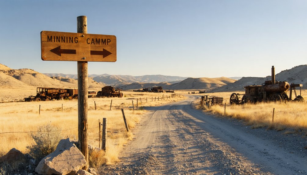
Mining Equipment and Artifacts
Beyond the decaying cabins and weathered walls, Tenderfoot’s industrial past reveals itself through rusted machinery and crumbling foundations scattered across the hillside. You’ll discover remnants of the 300-foot vertical shaft where miners once extracted tin ore, alongside weathered headframe structures that once supported hoisting cables.
Jaw crushers and stamp batteries—specialized mining tools essential for ore processing techniques—lie abandoned where they pulverized cassiterite into valuable concentrate. Crumbling compressor foundations mark where pneumatic systems powered underground operations, while deteriorating hoist bases anchor ghosts of steam-driven machinery.
The mine shop’s skeletal frame still stands, surrounded by fragments of crushing rolls and ore bins. Each artifact tells stories of hard-rock mining’s brutal reality, where fortunes were sought beneath South Dakota’s unforgiving Black Hills terrain.
Access and Visiting Conditions
Nestled eight miles south of Hill City along the historic Chicago, Burlington and Quincy Railroad corridor, Tenderfoot’s remains occupy a remote stretch of Tenderfoot Gulch that time has largely reclaimed. You’ll find minimal infrastructure from the original tin mining camp, with the landscape returning to its natural state. Visitor access requirements remain undefined since no established facilities or marked trails exist at this neglected site.
When planning your exploration, expect:
- Unmarked terrain with scattered evidence of mining operations hidden beneath vegetation
- Active railroad considerations as the historic line still influences approach routes
- Limited wayfinding resources requiring self-reliance and navigation skills
Historical documentation availability proves sparse, making your discovery feel genuinely untamed—perfect for those seeking authentic ghost town experiences beyond sanitized tourist destinations.
The Tin Mining Legacy of Harney Peak Company
When Richard Pierce panned for gold in the Black Hills during 1876, he couldn’t have imagined that the peculiar heavy particles clinging to his sluice would spark one of the West’s most audacious mining ventures. That tin discovery eventually birthed the British-backed Harney Peak Tin Company, which transformed Hill City into a boomtown of 3,000 souls by 1890.
You’ll find the company legacy etched across this landscape—crumbling mill foundations, abandoned shafts plunging 400 feet into pegmatite veins, and ghost camps like Addie clustered around exhausted claims. But prosperity proved illusory. The tin mining scandals that erupted in 1893 exposed fraudulent production reports and phantom profits, collapsing Britain’s heavily-capitalized dream into receivership. Superintendents stripped the machinery, ensuring no resurrection. Today, only foundations whisper of ambitions that died here.
Essential Supplies and Gear for Your Ghost Town Adventure

Before you venture into Tenderfoot’s weathered remnants, you’ll need more than curiosity—pack reliable GPS units and topographic maps, as cell service fades quickly in these remote Black Hills valleys.
Layer your clothing strategically for South Dakota’s unpredictable mountain weather, where morning sunshine can shift to afternoon thunderstorms within hours.
Stock your vehicle with extensive emergency supplies, including extra water, first aid provisions, and communication devices, since help may be miles away when exploring these isolated mining ruins.
The dirt track to Tenderfoot vanishes from cell towers and GPS satellites long before you spot the first collapsed homestead, making reliable navigation tools the difference between discovery and disaster. You’ll need layered redundancy: digital map integrations through apps like GaiaGPS or onX Offroad with pre-downloaded offline maps, crowd sourced mapping platforms like iOverlander for fuel stations and primitive campsites, and USGS 7.5-minute topographic sheets as your failsafe.
Pack these essentials for South Dakota’s remote backcountry:
- Garmin eTrex 20x handheld GPS for precise coordinate navigation when screens fail
- Magnetic compass paired with printed USGS maps for dead reckoning backup
- Portable battery bank to keep devices charged across multi-day exploration
Download waypoint folders marking obstacles and water sources before you lose signal. Freedom demands preparation.
Weather-Appropriate Clothing Layers
South Dakota’s backcountry doesn’t forgive wardrobe miscalculations—a sixty-degree morning can plunge to freezing by sunset, while spring’s deceptive sunshine masks wind chills that bite through cotton like paper.
Master the layering system importance by building three distinct zones: moisture-wicking merino wool against your skin, mid-weight fleece for adaptable warmth, and a windproof shell that breathes.
Proper insulation requirements shift dramatically—summer demands quick-dry synthetics for thunderstorm country, while winter exploration near Tenderfoot necessitates thick base layers and an insulated parka rated for sub-zero nights.
Pack versatile pieces that seamlessly convert: that lightweight puffy compresses into your daypack yet shields against 73 annual precipitation days. Your clothing becomes survival equipment when you’re miles from civilization, chasing history through abandoned streets where weather waits for no one.
Safety and Emergency Equipment
- Jumper cables and spare tire with jack for roadside breakdowns
- High-visibility vest and LED road flares marking your position on desolate highways
- Multi-tool, duct tape, and tow strap solving problems resourcefulness demands
- Junction City – Follow Tenderfoot Gulch to the Grand Junction mine site, where 7,000 tons of ore once fueled dreams worth $3.58 per ton
- Kiddville – Trek four miles up French Creek to this placer camp near the Penobscot Mine, where local folklore and legends still whisper through abandoned diggings
- Spokane – Near Hermosa, this repeatedly-failed revival town offers dust-laden authenticity
- A 40-stamp mill powered by an elevated flume system, processing ore from six different locations
- Equipment hauled by wagon from Bismarck, North Dakota—a testament to determination over distance
- “The Mansion” office building, signaling permanence in a world of temporary camps
- Early June through August: Full operational hours at Broken Boot Gold Mine (8am-6pm daily), though you’ll navigate higher crowds and sweltering 77-90°F heat
- September’s golden window: 74°F days paired with fall foliage transforming ghost towns into photographer’s dreams during the Buffalo Roundup
- Spring’s awakening (March-May): Peaceful exploration of Black Hills Mining Museum with minimal visitors and crisp air that won’t exhaust you while trekking between sites
- Unstable mine shafts riddle Tenderfoot’s terrain with collapse-prone excavations and toxic tailings from tin extraction
- Crumbling structures from nineteenth-century abandonment threaten sudden failure, especially near old mill sites
- Wildlife encounters intensify in remote gulches where coyotes and other fauna reclaim human spaces
Pack three days’ water, non-perishable food, emergency blankets, and navigation backups—paper maps outperform dead smartphones in South Dakota’s cellular dead zones.
Exploring Tenderfoot Gulch and Surrounding Areas
Nestled between Hill City and Custer in the heart of South Dakota’s Black Hills, Tenderfoot Gulch beckons modern explorers with whispers of its 1880s mining heyday. You’ll trace the old Chicago, Burlington and Quincy Railroad path through this forgotten canyon, where Junction City once thrived from 1879 to 1881.
Where narrow-gauge rails once rattled with ore cars, wildflowers now reclaim the grade through South Dakota’s ghost canyon.
The historical timeline reveals ambitious mining operations—the Grand Junction extracted 7,000 tons of ore, while the Tenderfoot Group‘s underground workings chased tin deposits at 6,001 feet elevation.
Today’s landscape still bears scars from that boom-and-bust era. You’ll discover the High Climb pegmatite outcropping along ridgelines, silent testimony to prospectors’ dreams. While mine locations sit on private property, the surrounding terrain offers unrestricted wandering.
Follow Fourmile Road toward Harney Peak and Sylvan Lake, where geology maps guide your off-grid adventure.
Nearby Ghost Towns Worth Adding to Your Itinerary
Beyond Tenderfoot’s abandoned gulches, a constellation of forgotten settlements dots the Black Hills and surrounding prairies, each preserving its own chapter of South Dakota’s boom-and-bust saga. You’ll discover stories of local mining personalities who chased fortune through these remote hills, their ambitions now echoing through empty structures.
Essential stops near Tenderfoot:
Each location rewards adventurous spirits willing to venture beyond marked trails into South Dakota’s untamed past.
Rochford: A More Substantial Stop Along the Way
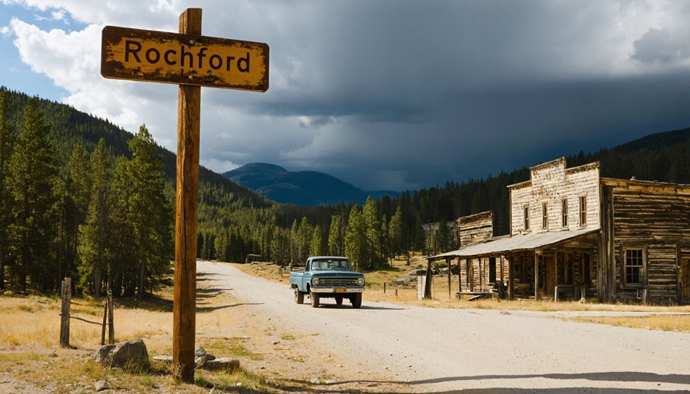
Unlike many Black Hills ghost towns reduced to foundation stones and fading memories, Rochford rises from the pines with genuine substance—a settlement that once housed over a thousand souls during its 1878 gold rush peak. You’ll find more than weathered boards here: a functioning saloon that’s poured drinks since 1910, the skeletal remains of what locals call “America’s smallest mall,” and enough standing structures to imagine the bustling mining district that M.D. Rochford platted in this steep gulch.
The town’s layout still follows those original 1878 lots, where Methodist hymns once competed with saloon revelry across dirt streets serving six stores, two hotels, and more than a hundred homes.
Rochford’s Impressive Mining Heritage
The Standby Mine exemplified this frontier ingenuity:
From 1878’s explosive growth to modern exploration companies eyeing the same gold-bearing formations, Rochford’s story reveals what happens when prospectors strike rich and refuse to quit.
The Homestake Gold Belt still beckons those seeking fortune beneath these ancient hills.
Town Layout and Amenities
Rochford sprang up in Irish Gulch during May 1878, when founders M.D. Rochford and Richard B. Hughes carved out lots along Little Rapid Creek at 5,302 feet elevation. You’ll find this was no temporary camp—the town’s population growth exploded to 500 residents within months, with another 500 settling in tents and shelters on surrounding hillsides.
Log cabin construction dominated the landscape, with over 100 structures dotting the gulch by December.
The settlement offered genuine civilization: six stores, three saloons, a Methodist Episcopal Church, theater, drugstore, restaurants, hotels, blacksmiths, and a school. You could purchase town lots for $10 to $60—reasonable stakes for your slice of Black Hills freedom. Unlike many boom-and-bust operations, Rochford built infrastructure meant to last.
Best Times of Year to Visit Black Hills Mining Sites
Planning your visit to Black Hills mining sites requires careful consideration of South Dakota’s dramatic seasonal shifts. You’ll find shoulder season hiking in May and late September delivers the perfect balance—comfortable 65-75°F temperatures, fewer tourists crowding abandoned shafts, and shoulder season mining access to remote locations without summer’s peak-hour congestion.
Prime visiting windows include:
Winter’s snow-choked roads fundamentally close the frontier.
Photography Tips for Capturing Abandoned Mining Locations
Once you’ve locked in your ideal visiting window, capturing these weathered relics demands more than simply pointing your camera at crumbling headframes. Your environmental documentation starts with wide-angle compositions—frame full scenes showing doorways swallowed by shadows, sand patterns, and sprawling emptiness.
Environmental documentation begins with wide-angle storytelling—capture doorways consumed by darkness, wind-sculpted sand, and the profound emptiness these abandoned places command.
Hunt for textures: cracked paint bleeding rust, wind-carved lines in dunes, forgotten hat hooks clinging to splintered walls. Shoot during late afternoon when slanted sun ignites backlit dust and stretches shadows across mining scars.
For structure preservation shots inside dark tunnels, you’ll need tripods and creative lighting—vehicle headlamps work brilliantly where power lines died decades ago. Expose for highlights, then lift shadows in post-processing.
Walk slowly, observe wind patterns, return repeatedly as light transforms these spaces, revealing their haunted spirit through your lens.
Respecting Historic Sites and Safety Precautions
The thrill of exploration carries weight—literal and legal—when you’re threading through Tenderfoot’s skeletal remains. These structures bear historic designations requiring preservation, meaning fines await those who disturb or vandalize what’s left. Site accessibility depends entirely on private property boundaries—many Black Hills ghost towns demand explicit permission before entry.
Your safety hinges on recognizing genuine hazards:
Stick to visible trails, avoid barred entrances, and photograph without touching. Respect what remains—these aren’t playgrounds but preserved monuments to extraction’s brutal economy.
Frequently Asked Questions
Are There Any Fees to Access Tenderfoot or Surrounding Ghost Towns?
You’ll find Tenderfoot accessible without entry fees, offering true freedom to explore. Parking availability lets you roam independently through weathered structures. However, nearby Nelson Ghost Town charges $10 per vehicle, while other attractions require paid admission for access.
Can I Camp Overnight Near Tenderfoot Mining Camp Area?
Like wanderers seeking shelter beneath endless skies, you’ll find nearby camping options limited near Tenderfoot. Research beforehand—dispersed camping possibilities exist on public lands where local wildlife sightings reward your adventurous spirit with unforgettable freedom.
Are Guided Tours Available for the Tenderfoot Gulch Region?
No guided tour itineraries specifically cover Tenderfoot Gulch’s remote terrain. You’ll forge your own path through this abandoned mining camp, though nearby Black Hills operators occasionally offer private tour experiences for adventurous souls seeking untamed historical sites.
What Cell Phone Coverage Exists in the Tenderfoot Area?
Cell phone signal strength in Tenderfoot’s remote terrain is unpredictable. You’ll face spotty availability of mobile data due to sparse towers and challenging topography. Verizon offers your best shot at connectivity, though dead zones remain common throughout this untamed region.
Are Any Original Buildings From Tenderfoot Still Standing Today?
Wondering what remains of this frontier outpost? You’ll find no original building conditions preserved—Tenderfoot’s classified as “neglected,” meaning structures have crumbled away. Only scattered remnants of daily life hint at the mining settlement that once thrived here.


