Starting in Volunteer, South Dakota, you’re perfectly positioned to loop through ghost town country across Hutchinson, Bon Homme, and Charles Mix counties. Follow U.S. Highway 18 east, then dip south along gravel county roads where abandoned storefronts, weathered churches, and forgotten cemeteries dot the prairie horizon. Fuel up in Tyndall or Olivet before heading out, and pack water, snacks, and offline maps. There’s far more to uncover about making this road trip both safe and unforgettable.
Key Takeaways
- Volunteer, South Dakota, along U.S. Highway 18, serves as an ideal starting point for exploring ghost towns across south-central and southeastern South Dakota.
- Plan a loop route heading east from Volunteer, south through Charles Mix County, and back through Hutchinson County via county roads.
- Fuel up in larger service towns like Tyndall, Olivet, or Parkston before venturing onto remote gravel roads with sparse gas stations.
- Pack essential supplies including water, snacks, a first aid kit, charged phone, and offline maps for areas with limited cell service.
- Always stay on public roads, avoid entering unstable structures, and respect posted private property boundaries during ghost town exploration.
Why Volunteer, South Dakota Is the Right Starting Point
Because it sits quietly along U.S. Highway 18 near the James River valley, Volunteer, South Dakota, gives you exactly what a ghost-town road tripper needs — an unhurried, open starting point.
Volunteer, South Dakota sits quietly along U.S. Highway 18 — the unhurried, open starting point every ghost-town road tripper needs.
Its historic significance runs deeper than its small footprint suggests, rooted in a proud volunteer fire company and a rural identity that locals still carry.
You’ll find scenic landscapes stretching across Hutchinson County’s wide prairie horizon, offering that raw, unfiltered freedom you’re chasing.
Local legends surrounding abandoned settlements and vanished rail-era communities pull you forward down every county road.
The community spirit here is quiet but real, reminding you that even unincorporated places hold stories worth honoring.
Start here, and let Volunteer anchor your route before the ghost towns ahead demand your full attention.
Ghost Towns Within a Day’s Drive of Volunteer
Once you leave Volunteer behind, a loose cluster of ghost towns fans out across south-central and southeastern South Dakota within a comfortable day’s drive.
Hutchinson, Bon Homme, Yankton, and Charles Mix counties all hold forgotten settlements worth tracking down. You’ll find abandoned structures ranging from weathered grain elevators to crumbling church foundations, each telling a quiet story about railroad decline and prairie hardship.
Rural exploration here means mixing paved state highways with short gravel county roads, so fuel up and load offline maps before you head out.
Spring mud and winter snow can cut off access fast, so timing matters. Stick to public roads, respect property boundaries, and use daylight hours to spot unmarked turnoffs.
The reward is wide-open country and history that most travelers never slow down to find.
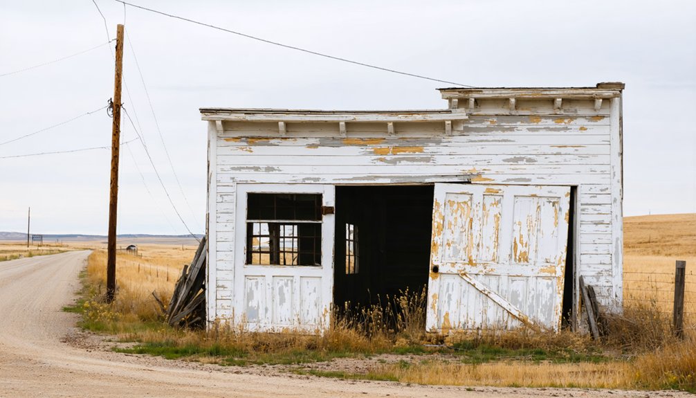
What’s Left Standing at Ghost Towns Along This Route?
Depending on which ghost town you roll into, what’s left standing can range from a single weathered storefront to a full street grid of collapsing buildings.
Prairie ghost towns near Volunteer typically leave behind churches, grain elevators, overgrown foundations, and old cemeteries. You’ll spot historic remnants like rusted farm equipment, broken concrete steps, and sun-bleached wood siding that tell the story without a single tour guide.
Further out toward the Black Hills, abandoned structures tend to include mining-era cabins, commercial shells, and collapsed outbuildings. Some sites offer nothing more than a cemetery marker and a gravel turnaround.
Bring your camera, respect the boundaries, and read the landscape carefully. Every crumbling wall holds a chapter of South Dakota history worth pausing over.
Plan Your Ghost Town Loop Through Hutchinson, Bon Homme, and Charles Mix Counties
Knowing what’s left standing is only half the work — the other half is figuring out how to connect the dots between those weathered remnants.
Build your loop by heading east from Volunteer into Bon Homme County, then swinging south through Charles Mix County before circling back through Hutchinson. You’ll find ghost town attractions scattered along county roads that reward patient, curious travelers.
Head east from Volunteer, drift south through Charles Mix, and circle back — ghost towns reward the patient ones.
Mix paved highways with short gravel stretches, but check seasonal conditions first — spring mud closes routes fast. Fuel up in larger towns before diving into rural exploration, because services disappear quickly once you leave the main corridors.
Use daylight hours to spot unmarked turnoffs, and keep offline maps loaded. This region rewards travelers who move deliberately and stay flexible.
Where to Fuel Up Before the Ghost Town Stretches
Before you head out on the rural stretches connecting Volunteer to abandoned prairie sites in Hutchinson, Bon Homme, and Charles Mix counties, you’ll want to top off your tank in a larger service town like Olivet, Tyndall, or Parkston.
These small regional hubs offer gas stations, basic supplies, and a last chance to grab food before long gravel-road segments with no services.
Map your fuel stops in advance, because running low between ghost towns on a remote county road isn’t a situation you want to find yourself in.
Nearest Fuel Stop Options
Fueling up before you head into the rural stretches around Volunteer is one of the smartest moves you can make, since gas stations thin out quickly once you leave the larger towns along U.S. Highway 18.
Check station hours ahead of time, because rural stops often close early.
Top nearby fuel stop towns to prioritize:
- Olivet – closest small-town option with basic fuel types available
- Parkston – larger selection, reliable hours, and convenience store access
- Tripp – solid stop heading west along Highway 18
- Tyndall – Bon Homme County seat with multiple stations and extended hours
Fill your tank completely before turning onto gravel county roads.
Running low miles from nowhere eliminates your freedom to explore spontaneously.
Towns With Gas Stations
Planning your fuel stops around specific towns rather than hoping for a lucky roadside find keeps your ghost-town road trip moving smoothly. Fuel availability thins out quickly once you leave the main corridors, so knowing your gas station locations ahead of time matters.
Olivet and Parkston both sit near Highway 18 and offer reliable fueling options before you push into quieter county roads. Freeman carries solid services as well, making it a smart stop heading southeast.
Tyndall, the Bon Homme County seat, gives you another dependable fuel point near the Missouri River bluffs. Always top off your tank in these towns before turning onto gravel stretches. A full tank means more freedom to explore without cutting your route short unexpectedly.
Planning Your Fuel Strategy
Three simple decisions—where you fuel up, when you fuel up, and how much you carry—determine how far into ghost-town country you can actually push.
Apply these fuel efficiency tips and route optimization strategies before leaving pavement behind:
- Fill your tank completely in Parkston or Freeman before heading toward Volunteer.
- Note every fuel stop along U.S. Highway 18—gaps between stations exceed 30 miles on rural segments.
- Carry a small approved fuel container when gravel county roads extend your planned mileage unexpectedly.
- Plan your longest ghost-town stretches during the first half of your day, while your tank is full.
Treat fuel like time—once it’s gone, your freedom shrinks. Smart planning keeps every abandoned crossroads within reach.
When to Go and Which Roads Hold Up in Each Season?

When you hit the back roads around Volunteer and neighboring counties, the season you choose can mean the difference between a smooth drive and a stuck truck.
Summer and fall offer the best seasonal conditions, with firmer gravel, longer daylight, and accessible turnoffs.
Spring brings mud that’ll swallow tires whole, especially on county roads with minimal road maintenance.
Winter snow covers unmarked paths and hides hazardous dips entirely.
If you’re chasing ghost towns through Hutchinson, Bon Homme, or Charles Mix counties, late June through October is your window.
Always check local county road reports before departing, and keep offline maps downloaded.
Paved highways like U.S. 18 stay reliable year-round, but those short gravel spurs connecting abandoned sites are a completely different story.
How to Explore Ghost Towns Without Getting Into Trouble
Ghost-town exploration around Volunteer rewards the curious traveler, but it demands a basic code of conduct that keeps you safe, legal, and welcome to return.
Follow these four essential safety precautions and legal considerations:
- Stay on public roads and designated pullouts — never cross fenced or posted private property without permission.
- Skip entering unstable structures — broken floors, open shafts, and collapsing roofs can seriously injure you.
- Carry water, a charged phone, and offline maps — rural Hutchinson County offers little help if something goes wrong.
- Respect posted boundaries and local signage — violations can mean trespassing charges that end your trip early.
Your freedom to roam these forgotten places depends entirely on how responsibly you treat them.
Frequently Asked Questions
Are There Guided Ghost Town Tours Available Near Volunteer, South Dakota?
Guided tours aren’t widely available near Volunteer, but you can explore ghost town history independently—charting your own course, following your own timeline, and discovering forgotten places on your own terms with offline maps ready.
Can You Camp Overnight Near Ghost Towns in Hutchinson County?
You’ll find limited camping options near Hutchinson County’s ghost towns, so plan ahead. Use established campgrounds, pack supplies, and follow essential safety tips like avoiding unstable structures and keeping your phone charged for emergencies.
What Photography Permits Are Needed at South Dakota Ghost Town Sites?
Like a free spirit roaming open skies, you won’t need formal permits at most sites. Follow ghost town etiquette, respect private property, and use these photography tips: shoot from public roads only.
Are Any Volunteer-Area Ghost Towns Accessible to Visitors With Disabilities?
Some accessible attractions near Volunteer let you explore ghost town history from paved pullouts and highway viewpoints. You’ll discover prairie remnants, old foundations, and weathered structures without leaving smooth, stable ground — perfect for freedom-seeking adventurers.
Do Local Historical Societies Sell Maps of Abandoned Prairie Towns Nearby?
You’ll often find local historical societies selling maps rich with abandoned town history and prairie town legends. They’re your best resource for uncovering hidden rural sites, so stop in and grab one before hitting those remote county roads.
References
- https://www.powderhouselodge.com/black-hills-attractions/fun-attractions/ghost-towns-of-western-south-dakota/?2021_TAG
- https://myxoadventures.com/the-ghost-town-of-spokane-south-dakota/
- https://www.tripadvisor.com/Attraction_Review-g54799-d22999414-Reviews-Scenic_Ghost_Town-Scenic_South_Dakota.html
- https://www.youtube.com/watch?v=_0WNYsFLSLA
- https://www.facebook.com/groups/1375914112551966/posts/3076620879147939/
- https://www.travelsouthdakota.com/trip-ideas/abandoned-beauty-ghost-towns-structures-south-dakota
- https://www.blackhillsroadtripofhope.org
- https://www.blackhillsbadlands.com/blog/post/old-west-legends-mines-ghost-towns-route-reimagined/
- https://en.wikipedia.org/wiki/List_of_ghost_towns_in_South_Dakota
- https://gfp.sd.gov/volunteer/


