Planning a ghost town road trip to Warren, California means heading into Mono County’s remote eastern Sierra Nevada, where mining-era ruins and high-desert silence reward the curious traveler. You’ll want a high-clearance vehicle, solid supplies, and a window between June and September for the best road conditions. Highway 395 connects Warren to other historic sites like Bodie, making a two-day loop entirely possible. Keep scrolling to uncover everything you’ll need before you go.
Key Takeaways
- Warren, California, is a remote eastern Sierra Nevada ghost town in Mono County, best accessed via Highway 395 through Bridgeport.
- Visit between June and September for reliable road access, mild temperatures, and longer daylight hours ideal for exploration and photography.
- High-clearance vehicles are recommended, as routes combine paved highways with unpaved back roads that vary by season.
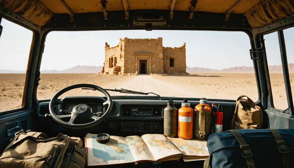
- Pack emergency gear, extra fuel, water, food, and offline maps, as services along Highway 395 are extremely sparse.
- A two-day itinerary works well, pairing Warren’s mining history with nearby Bodie’s preserved streets and Bridgeport dining.
Where Exactly Is Warren in the Eastern Sierra?
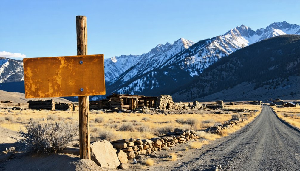
Warren, California sits tucked into the eastern Sierra Nevada, a region where high-desert valleys meet rugged mountain terrain along one of the West’s most storied corridors.
Warren geography places it within Mono County’s historic mining belt, where isolated passes once supported boom-and-bust settlements that rose fast and fell faster. You’re looking at a landscape shaped by gold, silver, and hard winters — remote by design, dramatic by nature.
Shaped by gold, silver, and brutal winters — this is a landscape that built fortunes fast and erased them faster.
The Eastern Sierra frames your approach with sweeping views and thin traffic, especially along Highway 395, which threads through the region like a spine connecting ghost towns, alpine lakes, and forgotten settlements.
Getting to Warren means embracing the distance. There aren’t many services out here, and that’s exactly the point — this stretch rewards drivers who come prepared and curious.
What Makes Warren, California Worth the Drive?
Few ghost towns earn the drive the way Warren does. You’re not just chasing Warren history — you’re stepping into a landscape that rewards curiosity with raw, unfiltered beauty.
The scenic landscapes surrounding Warren blend high desert silence with jagged Sierra peaks, creating something genuinely cinematic.
Here’s what pulls travelers off the main road:
- Preserved isolation — Warren sits far enough from tourist corridors that you’ll feel like you’ve actually discovered something.
- Layered history — Mining-era remnants tell a boom-and-bust story without a gift shop in sight.
- Dramatic surroundings — Alpine backdrops and open desert valleys frame every stop along your route.
You don’t need a packed itinerary here. You just need an open road and enough fuel to follow it.
Build Your Warren Road Trip Along Highway 395
Highway 395 is your backbone for this trip, threading through high desert and alpine terrain as it connects Bridgeport, Bodie, and the broader eastern Sierra ghost-town corridor.
You’ll want to time your stops carefully, since Bodie and other historic sites sit along unpaved, weather-sensitive side roads that reward patience but punish poor planning.
Before you leave the last town with a gas station, fill your tank and stock your supplies, because services thin out fast once you push into mining-country back roads.
Highway 395 Route Overview
Stretching through the eastern Sierra Nevada, U.S. 395 is the backbone of any Warren ghost-town road trip worth taking. This highway connects desert valleys, alpine passes, and forgotten mining corridors with effortless momentum.
You’ll move between scenic viewpoints and weathered history without losing your rhythm.
Pack these essentials before hitting 395:
- Fuel up in Bridgeport — services disappear fast once you head toward remote mining districts
- Chase the historical anecdotes — roadside markers reveal boom-and-bust stories that textbooks skip entirely
- Watch the elevation changes — desert floor shifts into high Sierra terrain within miles, changing road conditions dramatically
You’re not just driving a highway. You’re threading through California’s roughest, richest, and most abandoned chapter — and 395 keeps every mile honest.
Key Stops Along The Way
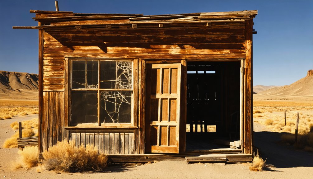
Building your Warren road trip along Highway 395 means threading together stops that earn their place on the itinerary — and Bodie State Historic Park anchors the whole route. California’s largest unrestored ghost town delivers dozens of abandoned buildings frozen in time, giving you a raw, unfiltered look at the 1880s mining era.
From there, Bridgeport pulls you in for fuel, supplies, and local cuisine worth slowing down for before you push into more remote terrain. Scenic viewpoints along the corridor reward drivers who pull over — high-desert valleys dropping away beneath jagged Sierra peaks create moments you won’t want to rush past.
Each stop builds context for the next, turning a simple drive into a layered experience that connects landscape, history, and open-road freedom.
Fuel And Supply Planning
Few stretches of California road leave you as exposed as the eastern Sierra corridor, so fuel and supply planning isn’t optional — it’s the difference between a smooth trip and a stressful one.
Bridgeport is your last reliable stop for fuel types and supply stores before remote segments begin. Fill your tank there and stock essentials before heading toward Warren or Bodie.
Keep these priorities locked in before you roll out:
- Top off fuel in Bridgeport — stations disappear fast beyond town
- Hit supply stores for water, snacks, and basic emergency gear
- Check road conditions since seasonal closures can strand unprepared drivers
Cell service fades quickly out here. Treat every resource stop as your last, and you’ll move through this corridor on your own terms.
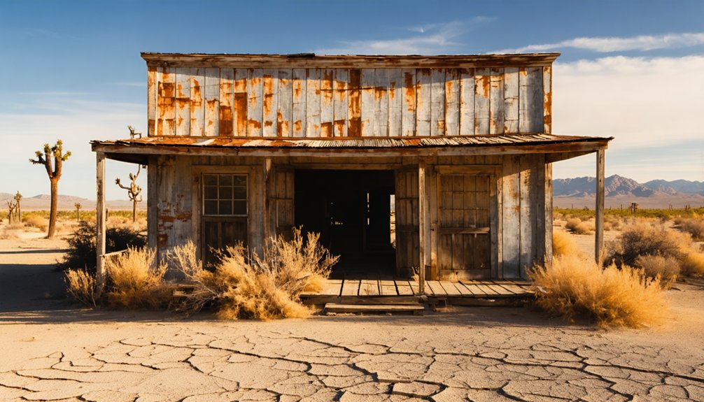
Make Bodie State Historic Park Your First Ghost Town Stop
Bodie State Historic Park sits about 13 miles east of U.S. 395 near Bridgeport, making it your most logical first stop before pushing deeper into the Warren corridor.
Bodie history runs deep here — at its 1880 peak, nearly 10,000 people lived and worked across this windswept basin, supported by almost 50 saloons.
Today, hundreds of abandoned structures remain frozen in a state of “arrested decay,” giving ghost town exploration a raw, unfiltered quality you won’t find at restored sites.
Hundreds of abandoned structures sit frozen in arrested decay — raw, unfiltered, and unlike anything you’ll find at a restored site.
Walk the empty streets, peer through dusty windows, and let the scale of this former boomtown settle over you.
Bodie sharpens your eye for what came next along the eastern Sierra corridor, priming you for the quieter, less-visited stops that lie ahead toward Warren.
More Ghost Towns and Mining Sites Worth Adding Nearby
Once you’ve walked Bodie’s empty streets, the eastern Sierra opens up a wider circuit of ghost towns and mining relics worth threading into your route. Ghost town exploration here rewards the curious traveler willing to push beyond the obvious stops.
Mining history runs deep in this corridor, and several sites add genuine texture to your drive.
- Bridgeport anchors your staging point with fuel, food, and access to surrounding historic sites.
- Empire Mine State Historic Park delivers a hard-rock mining experience with 367 miles of underground tunnels carved from California’s richest gold vein.
- Shasta State Historic Park extends your northern loop into California’s broader mining legacy if you’re building a longer route.
Keep your itinerary flexible—remote roads and seasonal closures can reshape your plans fast.
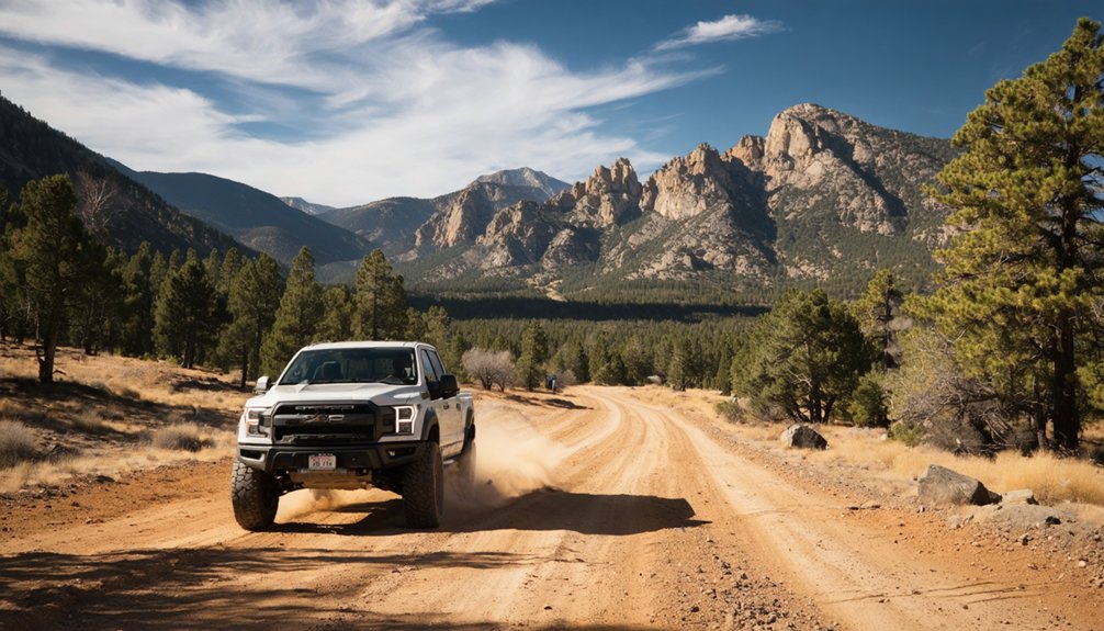
Road Conditions and Vehicle Requirements for Sierra Back Roads
When you head into the eastern Sierra backcountry around Warren, you’ll encounter a mix of paved highways, washboard gravel, and rough dirt tracks that shift dramatically with the season.
High-clearance vehicles handle the unpaved stretches far better than standard sedans, and some routes to remote mining sites genuinely demand four-wheel drive.
You’ll want to assess your vehicle’s capabilities honestly before committing to isolated roads where help can be miles away.
Terrain And Road Types
Maneuvering the Sierra back roads around Warren means trading smooth asphalt for a mix of graded gravel, rutted dirt tracks, and narrow mountain passes that shift dramatically with the seasons.
These scenic routes reward adventurous drivers who prepare carefully.
Before you roll out, know what you’re facing:
- Washboard gravel loosens tire pressure quickly, making regular tire maintenance essential on longer stretches
- Steep, rocky climbs near mining districts demand higher ground clearance and confident four-wheel-drive capability
- Seasonal washouts can transform passable dirt roads into impassable mud channels overnight
You’ll encounter dramatic elevation changes, exposed ridgelines, and desert valley floors within a single drive.
Check road conditions locally before departing, carry a spare, and stay alert—freedom out here belongs to those who respect the terrain.
Vehicle Clearance Requirements
Knowing the terrain is one thing—matching your vehicle to it’s another. Standard sedans handle Highway 395 without issue, but once you turn onto unpaved spurs toward remote mining sites, the rules change fast.
Rocky surfaces, eroded washboards, and steep grades demand higher ground clearance. Most vehicle types with six to eight inches of clearance manage moderate dirt roads comfortably, but heavily rutted or washed-out sections genuinely favor trucks and SUVs.
Road safety isn’t just about skill—it’s about hardware. A low-slung car bottoming out miles from cell service isn’t freedom; it’s a rescue situation.
Check road conditions before departure, confirm your spare tire’s inflated, and carry basic recovery gear. Your vehicle choice directly shapes how far you can roam.
Best Time to Visit Warren and the Eastern Sierra
Timing your visit to Warren and the eastern Sierra can make or break the trip. The best season runs from late spring through early fall, when roads open, skies clear, and the landscape rewards every mile driven.
Weather considerations matter here — Sierra winters bury access roads under heavy snow, cutting off ghost-town corridors entirely.
Plan around these seasonal advantages:
Plan your visit around the seasons — timing shapes everything from road access to light quality and crowd levels.
- June through September offers reliable access, long daylight hours, and mild temperatures across high-desert terrain.
- Early fall delivers cooler air, fewer crowds, and golden light perfect for photographing abandoned structures.
- Late spring brings wildflowers and snowmelt scenery, though some dirt roads remain soft and unpredictable.
Arrive prepared, stay flexible, and let the open road dictate your pace.
Once you’ve locked in your travel window, the next step is making sure your vehicle and pack list match the terrain. Eastern Sierra back roads near Warren demand real preparation, not afterthoughts.
Load your emergency gear before leaving cell range: a full-size spare, jumper cables, tow strap, basic toolkit, and a first-aid kit. Carry extra fuel, water, and food, since services thin out fast along remote stretches of Highway 395.
For navigation tips, don’t rely solely on your phone. Download offline maps, bring a paper backup, and mark your route waypoints in advance. A GPS device with topographic detail adds another layer of confidence.
Dress in layers, tell someone your itinerary, and keep a flashlight and blanket in the trunk. The desert rewards the prepared.
A Two-Day Loop: Warren, Bodie, and the Bridgeport Basin
With your gear packed and your route mapped, you’re ready to thread together the best of the eastern Sierra in a single two-day loop.
Day one traces Warren history through mining corridors, where scenic viewpoints reveal desert valleys dropping into alpine ridgelines.
Watch for local wildlife near the Walker River corridor and keep your camera ready — morning light transforms abandoned structures into compelling photography subjects.
Day two swings toward Bodie and the Bridgeport Basin:
- Explore Bodie’s preserved streets at dawn for the sharpest photography tips in practice
- Chase nearby hiking trails into hidden gems above the basin floor
- Sample local cuisine in Bridgeport before the drive home
Check seasonal events calendars — some routes close without warning.
Build flexibility into your schedule and let the landscape set the pace.
Frequently Asked Questions
Can I Camp Overnight Near Warren or the Surrounding Ghost Town Sites?
You’ll find camping regulations vary, but nearby campgrounds dot the Highway 395 corridor and Bridgeport area. Embrace the freedom of sleeping under Sierra stars before exploring Warren’s haunting, history-rich ghost town landscape at dawn.
Are Pets Allowed on the Trails and Roads Around Warren?
You and your pup can roam endless pet friendly trails around Warren, but you’ll want to keep them leashed — leash requirements apply, so don’t let your furry explorer vanish into the ghost-town wilderness alone!
Is There an Entrance Fee to Visit Warren or Nearby Historic Sites?
Warren itself doesn’t charge entrance fees, but you’ll encounter entrance regulations at nearby Bodie State Historic Park. Don’t let that curb your freedom—the modest fee honors the site’s remarkable historical significance and funds preservation efforts.
What Photography Rules Apply When Visiting Preserved Ghost Towns Near Warren?
You’ll photograph a thousand forgotten dreams at Bodie! You can shoot freely, but don’t move artifacts. Master composition techniques by framing weathered buildings against dramatic skies, and chase golden-hour lighting considerations for hauntingly beautiful, soul-stirring images.
Are Guided Tours Available for Warren and the Eastern Sierra Ghost Towns?
You’ll find guided exploration options at Bodie State Historic Park, where rangers lead you through streets rich with historical significance. Independent tours also let you roam freely, uncovering Warren’s eastern Sierra ghost towns on your own terms.
References
- https://www.visitcalifornia.com/now/california-ghost-towns-road-trip/
- https://www.facebook.com/groups/motorcyclistmap/posts/26253936157526674/
- https://www.barbaranusselphotography.com/blog/2017/4/20/wildflowers-and-ghost-towns-a-road-trip-through-central-california
- https://www.visitcalifornia.com/road-trips/ghost-towns/
- https://californiathroughmylens.com/zzyzx-road-healing-center-desert/
- https://www.youtube.com/watch?v=FEiWdlOSoiw
- https://www.alltrails.com/poi/us/california/warren-peak
- https://sierranewsonline.com/hiking-with-sally-from-lundy-lake-to-the-may-lundy-mine/
- https://www.facebook.com/groups/BodieFans/posts/9920753131321690/
- http://www.misadventuresmag.com/ghost-town-tour-california/


