Along Route 66 in western Oklahoma, you’ll find Texola, a ghost town that tells America’s story of boom and bust. Once a thriving cotton hub with four gins and over 500 residents in the 1930s, Texola emerged from early border disputes between Oklahoma and Texas. Today, fewer than 35 people call it home, but its historic jail, 1930 Magnolia Service Station, and abandoned storefronts preserve compelling tales of agricultural prosperity and Mother Road culture.
Key Takeaways
- Texola transformed from a thriving cotton town of 581 residents in 1930 to a ghost town with only 35 inhabitants today.
- The Great Depression, Dust Bowl, and cotton price crash from 35 to 9.4 cents devastated Texola’s agricultural economy.
- Interstate 40’s construction diverted traffic from Route 66, leading to the abandonment of businesses and population decline.
- Historic structures like the 1910 stone jail and 1930 Magnolia Service Station remain as preserved landmarks of Texola’s past.
- The town’s original Route 66 heritage attracts tourists despite most businesses being abandoned and streets largely empty.
From Boom to Bust: The Rise and Fall of a Route 66 Town
While many Route 66 towns experienced dramatic changes throughout the 20th century, Texola’s story stands as a particularly stark example of boom-and-bust economics.
You’ll find a town that emerged in 1901 amid contentious border disputes, where residents sometimes lived in different states without moving as surveyors repeatedly redefined the Oklahoma-Texas line. The town sits along the historic 100th meridian, marking a significant geographical division between the eastern and western United States.
In its heyday, you’d have seen a vibrant community of 581 residents by 1930, complete with hotels, restaurants, and the bustling Magnolia Service Station. The historic Texola Jail, built in 1910 with iron bars, still stands as a reminder of the town’s more populous days.
The town’s dramatic population shifts tell the tale – from prosperity to decline, as the Great Depression and Dust Bowl devastated the local agricultural economy.
When Interstate highways diverted traffic from Route 66, Texola’s fate was sealed.
Today, you’ll find just 40 residents in this near-ghost town, where abandoned buildings stand as silent witnesses to its former glory.
Life Along the 100th Meridian: Early Settlement Years
As settlers pushed westward along the 100th meridian in the late 1800s, they encountered a natural boundary that would shape Oklahoma’s early development. This invisible line marked where the humid East met the arid West, creating distinct settlement patterns as homesteaders adapted to changing environmental conditions.
You’d have found thousands of hopeful settlers participating in the land runs of the 1890s, rushing to claim 160-acre parcels in newly opened territories near the meridian. The historic Run of ’89 established major settlements including Oklahoma City, Kingfisher, and Guthrie.
These homesteading challenges weren’t just environmental – they were legal too. Boundary disputes between Texas and Oklahoma created uncertainty until the 1896 Supreme Court ruling settled the question of Greer County’s jurisdiction.
Legal battles raged between Texas and Oklahoma over disputed territories until the Supreme Court’s 1896 ruling finally settled Greer County’s fate.
Through Congressional acts and political maneuvering, settlers eventually gained clearer rights to establish their claims, transforming tribal lands into private homesteads along this vital geographic divide. A Joint Commission established in 1886 remained deadlocked over resolving the contentious boundary dispute between Texas and Oklahoma Territory.
Cotton Kingdom: Agricultural Glory Days
You’ll find Texola’s agricultural heyday centered around its impressive cotton industry, which supported four bustling cotton gins by the 1930s and employed much of the town’s peak population of 581 residents.
The town’s prosperity reflected the wider cotton boom across southern Oklahoma, where farmers devoted a quarter of their cultivated land to this valuable cash crop.
Early agricultural operations were supported by a gristmill and bank that helped process grain and finance farming ventures.
The Choctaw Railroad helped establish Texola in 1902, providing vital transportation for the area’s agricultural products.
Texola’s cotton empire wouldn’t last forever though, as the combined forces of the Great Depression and Dust Bowl brought an end to this golden age of agriculture.
Cotton Boom and Bust
When Oklahoma achieved statehood in 1907, cotton had already established itself as the region’s agricultural cornerstone, with nearly one-fourth of the state’s farmland dedicated to its cultivation.
The state’s cotton farms generated an impressive income of $118 million annually between 1923 and 1929, making Oklahoma the third-largest cotton producer in the nation.
You’d find about 300 cotton gins across the state, processing the white gold into standardized bales, while textile mills and cottonseed oil facilities supported the growing industry.
In Texola, you could witness this prosperity firsthand. By 1909, two cotton gins anchored the town’s economy, and local businesses flourished.
The town reached its population peak of 581 residents in 1930, reflecting the success of the cotton industry.
When cotton prices soared to 35 cents per pound in 1919, farmers rushed to plant more. But this optimism wouldn’t last.
The devastating price crash to 9.4 cents in 1920-21, combined with the persistent boll weevil threat, brought severe economic challenges that would forever alter Texola’s destiny.
Peak Production Years 1930s
Despite the economic turmoil of the early 1920s, Texola rebounded to reach its pinnacle during the 1930s. You’d have witnessed Texola’s economy flourishing with a population of 581 and four bustling cotton gins processing the region’s abundant harvests.
The town’s liveliness was evident in its vibrant infrastructure, including a ten-acre park and 300-seat auditorium where you could gather with neighbors. Like many farming communities at the time, residents experienced a devastating 64% drop in income as agricultural conditions deteriorated nationwide.
You’d have found a self-sufficient community with three hotels, multiple churches, and various businesses serving both locals and travelers. The 100th Meridian marked the town’s unique geographic position. The strategic location along the Choctaw, Oklahoma and Gulf Railroad line fueled this prosperity.
Community resilience showed through the town’s diverse amenities – from blacksmith shops to general stores. While the impending Dust Bowl would soon challenge this golden age, Texola’s 1930s embodied the height of Oklahoma’s Cotton Kingdom era.
Local Cotton Gin Empire
The thriving cotton gin empire in Texola began modestly with two processing facilities in 1909, setting the foundation for the town’s agricultural dominance.
You’d have witnessed remarkable cotton innovation as the industry expanded to four gins by the 1930s, doubling the town’s processing capacity and creating a bustling agricultural hub.
As ginning techniques improved, Texola’s cotton operations supported a vibrant community of 581 residents.
You’d have seen how the gins transformed raw cotton into market-ready bales, while seeds were repurposed for oil production and livestock feed.
The prosperity brought by this cotton kingdom funded impressive amenities, including a ten-acre park and a 300-seat auditorium.
The gins weren’t just processing centers – they were the economic engines that powered Texola’s banks, stores, and hotels during the town’s golden age.
Historic Landmarks That Stand the Test of Time

Standing proudly against time’s relentless march, Texola’s historic landmarks offer visitors a glimpse into America’s Route 66 heritage.
You’ll find the 1930 Magnolia Service Station, listed in the National Register of Historic Places, standing at the iconic intersection where Route 66 splits. Its cultural significance demands historic preservation efforts to protect it from further deterioration.
The pre-1910 one-room stone jail, built from cinderblock, remains one of the town’s few intact original structures.
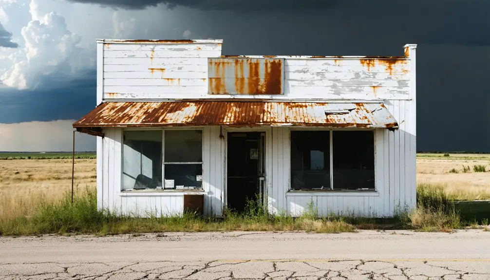
Alongside it, you’ll discover abandoned commercial buildings that tell stories of bygone prosperity, including shuttered stores and meat markets.
Don’t miss the old diner with its bold “No place like Texola” declaration, a reflection of the town’s enduring spirit despite its population dropping from 581 in 1930 to around 35 today.
The Legacy of America’s Mother Road in Texola
You’ll find Route 66’s golden era deeply etched in Texola’s story, where the 1930s brought a bustling community of 580 residents supported by the Magnolia Service Station, hotels, and the famous Tumbleweed Grill.
Today’s quiet streets and weathered buildings stand as silent witnesses to the lost highway heritage, when this westernmost Oklahoma Route 66 town served as an essential pit stop for cross-country travelers.
While most of Texola’s original Route 66 businesses have vanished, the town’s preserved landmarks, including the historic jail and service station, continue to draw Mother Road enthusiasts who appreciate these authentic pieces of American roadside history.
Route 66’s Golden Years
Post-war prosperity ushered in a golden age for Texola along Route 66, as millions of returning veterans migrated through Oklahoma’s stretch of America’s Mother Road.
You’d find flourishing motels, tourist courts, and service stations catering to the surge of automobile travelers seeking adventure and new beginnings in the Sunbelt states.
During these golden nostalgic years, Texola embodied the quintessential small town experience that defined Route 66’s identity as Main Street of America.
Local businesses thrived on passing travelers who’d stop for fuel, food, and lodging.
Tourist attractions popped up to serve families on cross-country road trips, while songs like “Get Your Kicks on Route 66” celebrated the freedom of the open road.
The town’s position along this iconic highway made it an essential part of mid-century America’s cultural transformation.
Lost Highway Heritage
Today, remnants of Texola’s vibrant past echo through its empty streets, serving as a poignant tribute to Route 66’s enduring legacy.
You’ll find architectural ghosts of mid-century roadside nostalgia in the weathered gas stations and motels that line the forgotten highway. These structures tell stories of a lost culture when travelers would stop to experience the unique blend of Oklahoma and Texas traditions.
While Interstate 40 may have bypassed this once-bustling town, Texola’s significance hasn’t diminished among Route 66 enthusiasts.
You can still explore the original alignment where heritage tourists document the town’s classic Americana charm. Despite its quiet state, Texola stands as a reflection of the transformative power of America’s highway system, preserving memories of the Mother Road’s golden age.
Preserving Roadside History
While many Route 66 landmarks have vanished over time, Texola’s historic structures stand as crucial representations of America’s roadside heritage.
You’ll find the 1930 Magnolia Service Station, listed on the National Register of Historic Places, showcasing classic roadside architecture that defined the Mother Road’s golden age.
The One Room Jail and Friendly Cafe ruins offer glimpses into the town’s vibrant past, when travelers regularly stopped at local businesses along this famous highway.
Community engagement remains essential to preservation efforts, with historical markers and exhibits helping to tell Texola’s story.
The town’s original layout, preserved storefronts, and documented history through the Texola Herald archives keep the spirit of Route 66 alive, despite challenges from declining population and the bypass of Interstate 40.
A Photographer’s Paradise: Capturing Abandoned Americana
Photographers seeking authentic pieces of American history will find a treasure trove in Texola’s abandoned landscape.
You’ll discover iconic structures like the Magnolia Service Station, listed on the National Register of Historic Places, offering compelling shots of America’s roadside heritage. The 1910 Territorial Jail, with its single cell and outlaw memorabilia, provides unique opportunities for nostalgic photography.
As you explore the town’s derelict commercial buildings, you’ll encounter abandoned bars adorned with vintage slogans and the shell of an auditorium that once seated 300 people.
The contrast between decay and preservation is striking at spots like the restored Tumbleweed Grill, housed in the 1930s Water Hole No. 2 building. Each abandoned structure tells a story of Texola’s rise and fall along Route 66.
Frequently Asked Questions
Is It Legal to Explore and Photograph the Abandoned Buildings?
You’ll need property owners’ permission for legal urban exploration and interior photography. From public spaces, you’re free to photograph exteriors while following photography ethics and respecting local community boundaries.
Are There Any Accommodation Options for Overnight Stays Near Texola?
While you can’t crash in Texola’s ghost town accommodations, you’ll find plenty of nearby lodging options in Shamrock (14 miles) and Erick (7 miles), with hotels ranging from budget-friendly Motel 6 to upscale Best Western Plus.
What Happened to the Families Who Left Texola?
You’ll find most families headed west to California during the Dust Bowl, seeking better opportunities. Their family stories reveal the historical impact of this migration, with others settling in nearby towns.
Does Anyone Still Maintain the Historic Magnolia Service Station?
You won’t find active maintenance at the historic Magnolia Service Station today. While it’s listed for historic preservation, there’s no formal upkeep program – it stands as local history slowly weathering time.
When Was the Last Time Texola Had a Functioning School?
Like a fading photograph, Texola’s school history ended around the early 1940s, when your community’s declining population led to district consolidation. You’ll now find students attending Erick Public Schools instead.
References
- https://www.legendsofamerica.com/ok-erick/
- https://www.islands.com/1870004/oklahoma-town-route-66-almost-abandoned-curious-historical-sites/
- https://icatchshadows.com/a-visit-to-texola-oklahoma-a-near-ghost-town-on-old-route-66/
- https://www.youtube.com/watch?v=0enwBg8Glrk
- https://route66mc.com/town.php?ID=402
- https://www.theroute-66.com/texola.html
- https://www.youtube.com/watch?v=gg3ICLT5OZY
- https://www.okhistory.org/publications/enc/entry?entry=OL002
- https://nationalcowboymuseum.org/explore/rushes-statehood-oklahoma-land-runs/
- https://www.okhistory.org/publications/enc/entry?entry=SE024


