When exploring coastal fishing hamlet ruins, research maritime history first and time your visit with low tides for ideal visibility. Pack waterproof footwear, tide charts, and documentation tools. Look for aligned stones, wooden posts, and arc-shaped breakwaters that reveal ancient infrastructure. Document findings carefully in waterproof notebooks and respect preservation laws. Watch for cultural markers like shrines and burial cairns while staying aware of erosion threats. These remnants hold secrets waiting to be uncovered with proper preparation.
Key Takeaways
- Plan your visit according to tide tables, arriving 1-2 hours before low tide for optimal visibility of submerged structures.
- Invest in waterproof footwear with good traction to safely navigate slippery coastal terrain and prevent heat loss.
- Document findings with detailed notes, photographs, and measurements while preserving archaeological integrity.
- Identify fishing infrastructure like stone quays, jetties, and breakwaters by looking for aligned stones and construction patterns.
- Monitor weather conditions and coastal hazards, postponing exploration during storms to ensure safety around unstable ruins.
Research the Maritime History Before Your Visit
Before commencing your exploration of coastal fishing hamlet ruins, you’ll benefit tremendously from researching the maritime history that shaped these communities. Investigate port-books, historic maps, and cartographic records from hydrographic offices to understand how the settlement evolved through different economic periods.
Many hamlets originated during the 17th and 18th centuries when specific maritime activities like whaling or cod fishing dominated.
Delve into maritime folklore and oral histories that reveal the community’s social structure, where family-based labor divisions often determined daily life.
Look for evidence of economic shifts—many villages shifted from fishing to tourism following infrastructure developments like railways. Many coastal communities adapted by turning to alternative livelihoods like cranberry farming when traditional maritime industries declined.
In places like Borth, examining historical records can reveal how the herring season from September to January shaped the entire rhythm and culture of the village.
Understanding the seasonal nature of historic fishing operations tied to migration patterns will provide essential context for interpreting the physical ruins you’ll encounter during your visit.
Time Your Exploration With Tidal Cycles
Successful exploration of coastal fishing hamlet ruins depends critically on understanding and planning around tidal cycles, as these natural rhythms determine both access and safety at seaside archaeological sites.
You’ll discover considerably more archaeological features during low tide when submerged structures become visible and accessible.
Consult tide tables before your visit and plan to arrive 1-2 hours before low tide, allowing maximum exploration time before the inevitable return of water.
Timing is crucial—arrive before the tide bottoms out to maximize your archaeological window of opportunity.
Recognize that tide patterns vary seasonally, with spring tides exposing more foreshore during full and new moons.
Always remain vigilant about tidal safety—rising waters can isolate visitors on previously accessible areas with alarming speed.
The strongest currents occur during tide shifts, presenting additional hazards.
Track weather forecasts, as storms can amplify tidal effects and create dangerous conditions at otherwise manageable sites.
In Orkney specifically, the increasing storm intensity has accelerated coastal erosion, potentially exposing new archaeological features but also threatening their preservation.
Be aware that large tidal ranges can cause water level changes of up to 10 meters in some coastal regions, significantly altering accessibility to ruins throughout the day.
Pack Essential Gear for Coastal Terrain
When exploring coastal fishing hamlet ruins, you’ll need waterproof boots with exceptional traction that protect your feet from sharp debris while traversing slippery, tide-washed stones.
Equip yourself with tide charts, a waterproof watch, and possibly a marine weather radio to monitor changing conditions that can quickly alter access routes to historical sites. Include a comprehensive first aid kit to treat minor injuries like cuts and blisters you might encounter on sharp coastal rocks.
Carry a camera with polarizing filter, notebook in waterproof case, and measuring tools to document architectural features and artifacts without moving or damaging the fragile historical remains. Look for remnants of traditional fishing equipment like nets and traps that reflect the cultural identity of these historical coastal communities.
Waterproof Footwear Matters
Although often overlooked by inexperienced coastal explorers, waterproof footwear represents a critical component of your essential gear when traversing coastal fishing hamlet ruins.
The waterproof benefits extend beyond mere comfort—they prevent blisters, reduce heat loss in colder climates, and mitigate risks of trench foot during prolonged moisture exposure. Wet shoes and feet cause extreme body heat loss through conduction, making proper waterproof footwear essential.
Select footwear demonstrating terrain adaptability with GORE-TEX membranes, deep lug patterns (4mm+), and abrasion-resistant materials.
Consider waterproof hiking boots for uneven terrain, neoprene options for shallow crossings, or treated leather boots for durability on abrasive surfaces.
Always test your footwear with waterproof socks before departure, and pack gaiters to prevent saltwater intrusion.
Remember to clean thoroughly between uses—saltwater degrades materials quickly, compromising both waterproofing and structural integrity.
Hiking poles provide essential balance and stability when navigating the slippery and uneven surfaces common in coastal ruins.
Tide Timing Tools
Beyond proper footwear, accurate tide timing represents the cornerstone of safe coastal ruin exploration. Invest in a tide clock with lunar-driven mechanics calibrated to the 12-hour 25-minute tidal cycle—vital for predicting water depths around submerged structures and planning safe access windows.
Enhance your preparation with digital tide apps like Tide Alert or Imray Tides Planner that incorporate NOAA datasets for real-time monitoring. The tidal range can dramatically transform coastal landscapes multiple times daily, making continuous monitoring essential. Conducting thorough reconnaissance before fishing will significantly improve both safety and productivity during your coastal explorations.
These tools offer customizable tide stations specific to your exploration area while providing essential information on tidal currents, moon phases, and monthly forecasts.
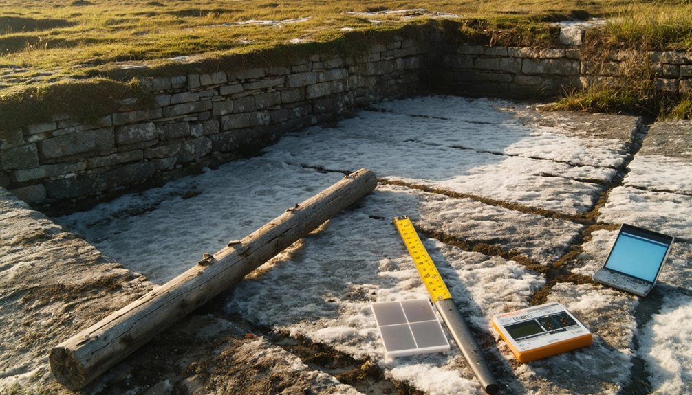
Document Without Disturbing
Documentation of coastal fishing hamlet ruins requires three essential principles: observe meticulously, record thoroughly, and disturb nothing. Pack a water-resistant field notebook, camera with protective casing, and GPS device to document findings accurately without physical contact.
Employ non-invasive techniques by using soft paintbrushes for gentle debris removal and plastic flagging tape for marking areas without site disturbance.
When exploring, wear waterproof boots and durable clothing to navigate coastal terrain while protecting yourself and the environment. For artifact preservation, avoid direct handling; instead, photograph items in situ and record precise measurements using your 3-meter tape.
If surface artifacts must be temporarily collected, use zipper-lock bags with detailed labeling. Remember that documentation through careful observation preserves archaeological integrity for future research and maintains these coastal sites’ historical value.
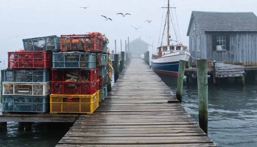
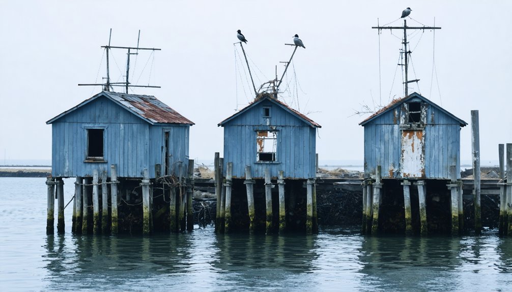
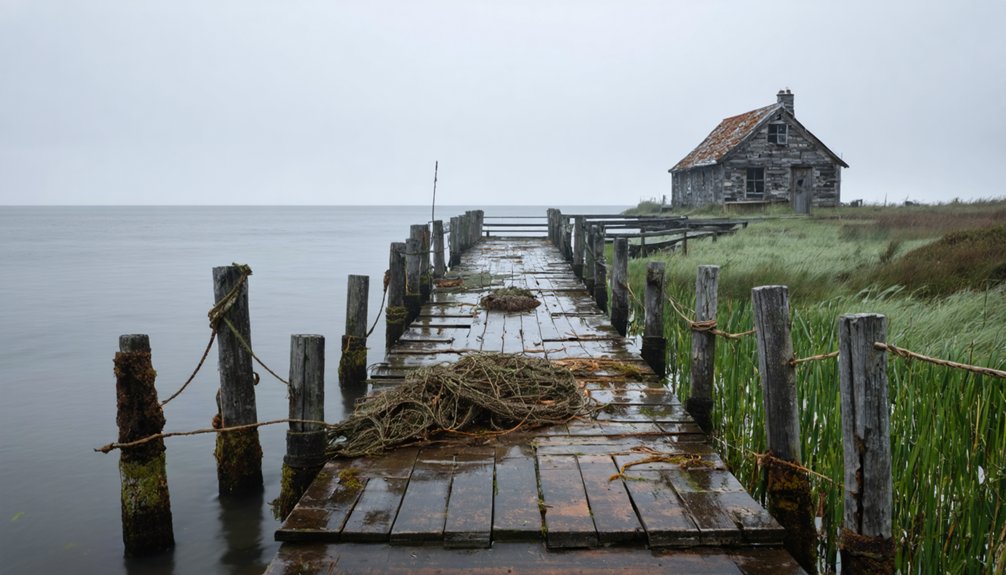
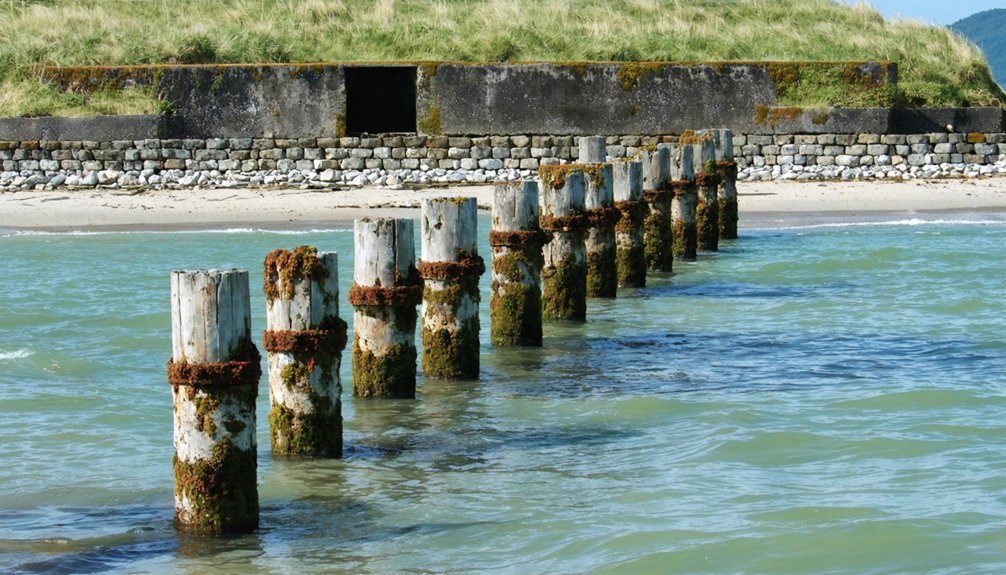
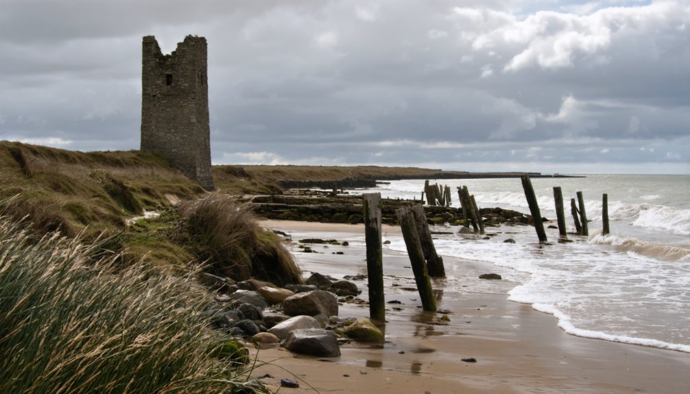
Identify Remnants of Fishing Infrastructure
When exploring coastal hamlet ruins, you’ll find ancient quays partially submerged beneath tidal waters, marked by aligned stones or weathered wooden posts still visible at low tide.
Carefully examine jetties extending into deeper waters, noting their construction techniques that often incorporated local materials with strategic positioning to shelter vessels from prevailing winds.
The remains of stone breakwaters, typically identified by their arc-shaped configurations and massive foundation blocks, reveal sophisticated engineering methods that protected these fishing communities from destructive wave action.
Coastal Quays Uncovered
Identifying ancient quays along coastal fishing hamlet ruins requires careful observation of distinctive architectural elements and strategic positioning along shorelines.
Look for remnants of masonry walls, timber pilings, and metal fixtures like mooring rings or bollards running parallel to the waterline. The quay architecture typically includes durable materials—granite blocks, reinforced concrete, or timber beams—designed to withstand tidal forces.
Examine the site for loading platforms, staircases, or ramps that connected quays to settlement areas. Semicircular or linear configurations maximize berthing space while following natural shoreline contours.
Evidence of fishing traditions appears in nearby sediments as fish bones, scales, and processing waste. Metal fastenings, corroded chains, and drainage features indicate functional aspects of these maritime structures, while repair patterns reveal continuous historical use and adaptation.
Examining Ancient Jetties
Ancient jetties provide critical insights into maritime activities and infrastructure of historical fishing communities. When exploring coastal ruins, look for linear structures extending from shorelines using aerial imagery or ground surveys. The historical significance of these features lies in what they reveal about past maritime economies.
You’ll want to identify wooden piles, stone foundations, or composite materials that indicate jetty construction techniques. Search for associated artifacts like net weights, hooks, or fish processing debris that confirm fishing activities. Dating techniques such as dendrochronology and radiocarbon analysis can establish chronology.
Remember that preservation varies widely—waterlogged conditions favor wood preservation, while coastal erosion might expose or destroy evidence. Document any carpentry joints or tool marks, as these details illuminate construction methods and technological capabilities of ancient fishing communities.
Stone Breakwater Remains
Stone breakwater remains represent critical protective structures in coastal fishing communities, functioning as wave barriers that sheltered boats and shoreline operations from harsh maritime conditions.
When employing stone identification techniques, look for layered rubble mound structures with large armor stones arranged parallel to shorelines, often partially submerged.
Breakwater construction methods typically feature a broad berm near water level with multiple structural layers: an outer armor layer of heavy stones, underlying filter layers, and a core of smaller material.
You’ll find these remnants near landing sites, quays, or natural bays where fishing vessels once docked. Note imported stones differing from native rock—evidence of historic repairs.
Environmental indicators include scour holes near the structure’s base and uneven stone formations suggesting collapse from storm damage.
Document Archaeological Features Responsibly
When approaching coastal fishing hamlet ruins, proper documentation serves as the foundation of responsible archaeological practice. Always use non-destructive techniques to record features like stone breakwaters or foundation remains. Photograph artifacts with clear labels and scale markers, ensuring each item has a unique identification number that connects it to its original context.
Responsible documentation requires balancing thoroughness with archaeological ethics. Maintain detailed field notes using standardized formats, and create scaled drawings to capture spatial relationships accurately.
When documenting sensitive areas, respect cultural significance by consulting with local communities and following applicable preservation laws. Consider using photogrammetry for complex structures while minimizing site disturbance.
Remember that your records may become the only remaining evidence of these coastal settlements, making accuracy and completeness paramount.
Look for Cultural and Spiritual Markers
Moving beyond physical documentation, your exploration of coastal fishing hamlet ruins reaches its fullest potential when you recognize the cultural and spiritual dimensions encoded within these sites.
Watch for burial markers near shorelines—rock cairns, small monuments, or oil urns—that reflect maritime identity and spiritual significance.
Seek out religious structures like seaside shrines and altars, often adorned with wave motifs or marine symbols.
Community gathering spaces, such as central plazas or fire pits, reveal collective spiritual practices through their design and artifacts.
The physical arrangement of shared spaces echoes ancient communal rituals, where daily gatherings transcended survival to become sacred acts.
Note decorative elements on walls and tools that express cultural symbolism through marine imagery.
These markers connect you to the hamlet’s spiritual heritage, preserved through generations in physical form and local lore.
Understanding these elements transforms your experience from observation to meaningful interpretation.
Understand Coastal Erosion’s Impact on Ruins
As you examine coastal fishing hamlet ruins, understanding the forces of coastal erosion becomes essential for interpreting site conditions and preservation challenges.
Recognize how waves, currents, and storms accelerate land loss through hydraulic action and abrasion, causing structural damage and eventual building collapse.
Look for evidence of human activities that exacerbated erosion—dredging that removed protective beach materials, vegetation clearance, or failed sea defenses.
You’ll often find sites experiencing annual recession rates of nearly two meters, with cultural heritage rapidly disappearing into the sea.
When exploring these vulnerable spaces, you’re witnessing the intersection of natural processes and heritage preservation challenges.
Climate change and rising sea levels are intensifying these effects, transforming once-thriving communities into archaeological remnants that document both environmental change and human adaptation.
Connect With Local Knowledge Keepers
When investigating coastal fishing hamlet ruins, you’ll gain invaluable insights by consulting Indigenous knowledge keepers who maintain oral histories spanning generations about land use, fishing practices, and environmental changes.
Approach coastal elders with respect, acknowledging their position as custodians of traditional ecological knowledge that contextualizes archaeological findings within cultural frameworks and historical narratives.
Establish relationships with local fishermen and long-term residents through community organizations, as they often possess detailed understanding of maritime technologies, seasonal patterns, and site-specific information that conventional research might overlook.
Seek Indigenous Wisdom
Indigenous Traditional Ecological Knowledge (TEK) forms the cornerstone of sustainable coastal management practices that have endured for millennia. When exploring fishing hamlet ruins, approach indigenous knowledge keepers with respect, acknowledging their role in preserving cultural heritage through indigenous storytelling and traditional practices. Their insights reveal the intricate relationship between ancient fishing communities and marine ecosystems.
To meaningfully engage with indigenous wisdom:
- Participate in community-led discussions where elders share oral traditions about seasonal fishing patterns and ecological indicators.
- Learn about site-specific traditional practices like stone tidal weirs that demonstrate sustainable harvesting techniques.
- Document (with permission) the connection between tangible ruins and intangible cultural knowledge that explains how these communities thrived without depleting resources.
This approach honors indigenous stewardship while enriching your understanding of coastal archaeological sites beyond their physical remains.
Consult Coastal Elders
Consulting coastal elders represents a critical methodological approach for anyone researching fishing hamlet ruins. These knowledge keepers hold invaluable information about historical fishing grounds and settlement patterns that often elude conventional archaeological methods.
Arrange elder interviews through local fishing cooperatives or cultural organizations, using semi-structured formats that allow narratives to unfold naturally. Record sessions (with permission) to capture nuanced terminology and place names.
When conducting knowledge sharing sessions, consider organizing focus groups where multiple elders can triangulate information and build upon each other’s recollections.
Remember that establishing trust takes time. Make repeated visits, demonstrate respect for cultural protocols, and acknowledge intellectual property rights.
Cross-reference elders’ accounts with archaeological evidence to create a more complete understanding of coastal hamlet histories and their environmental contexts.
Incorporating insights from colonial ghost town explorations can provide valuable context to the narratives surrounding these coastal settlements. The interplay of historical relics and oral histories often reveals the complexities and challenges faced by early inhabitants. Understanding these dynamics further enriches the overall narrative of place and identity in these regions.
Charting the waters surrounding coastal fishing hamlet ruins requires meticulous attention to hidden dangers beneath the surface. When practicing underwater navigation, utilize GPS and updated charts to identify potential submerged hazards, but don’t rely solely on electronic data—recent storms may have altered the seabed topology or introduced debris. Visual surveys and local knowledge notably enhance your safety margin.
- Maintain safe distance from cliff faces and coves where unstable ruins may extend underwater.
- Deploy echo sounders to detect obstructions, adjusting for vessel draft variations.
- Add custom hazard markers to your digital charts where known dangers exist.
During kona storms or high winds (exceeding 15 knots), postpone your exploration as these conditions amplify collision risks with partially submerged structures and create unpredictable currents around ancient fishing village remnants.
Respect Environmental and Heritage Protections
Four overlapping systems of protection govern coastal fishing hamlet ruins: environmental laws, heritage preservation statutes, traditional use designations, and marine conservation zones.
Before visiting these sites for heritage tourism, verify compliance requirements with local authorities and obtain necessary permits.
Always adhere to established pathways and avoid disturbing artifacts or ecological features—what seems insignificant to you may hold archaeological importance.
Recent legislation, including the 2021 Infrastructure Investment Act, strengthens protections against climate impacts that threaten these fragile sites.
Remember that sustainable practices extend beyond leaving no trace. Engage respectfully with local communities who maintain traditional relationships with these locations.
Their knowledge often informs conservation efforts and can enhance your understanding of the delicate balance between cultural preservation and environmental protection.
Frequently Asked Questions
How Do I Identify Ancient Fishing Tool Remains Versus Natural Debris?
Examine materials (bone, shell, metal), look for deliberate shaping or wear patterns, and note contextual positioning. You’ll distinguish ancient fishing tool remains from natural debris through methodical material and morphology comparison.
Can I Visit Ruins During Storm Season?
Dark clouds herald danger. You shouldn’t visit coastal ruins during storm season. Storm safety protocols often restrict access, and travel precautions recommend exploring during calmer months when structural integrity isn’t compromised by unpredictable weather.
What Underwater Photography Equipment Works Best for Documenting Submerged Structures?
You’ll need compact underwater cameras with RAW capability housed in quality waterproof casings like Ikelite or Nauticam. Pair them with proper lighting techniques using strobes to reveal structural details effectively.
Are Fishing Hamlet Artifacts Legally Protected in International Waters?
While you might assume fishing rights trump cultural protection, they don’t. In international waters, fishing hamlet artifacts over 100 years old are legally protected under maritime laws including UNESCO’s Convention, though enforcement remains challenging without universal ratification.
How Do Burial Customs Differ Between Coastal and Inland Fishing Communities?
You’ll find coastal traditions emphasize marine symbolism with Tuesday burials, while inland practices favor agricultural motifs and weekend ceremonies. Coastal communities integrate sea deities, whereas inland groups follow terrestrial or Christian calendars.
References
- https://lokeysouls.com/2022/03/15/fishing-hamlet/
- https://www.fao.org/4/v5270e/v5270e00.htm
- https://en.wikipedia.org/wiki/Hampton-on-Sea
- https://www.frdc.com.au/sites/default/files/products/2002-223-DLD.pdf
- https://en.wikipedia.org/wiki/Capernaum
- https://en.wikipedia.org/wiki/List_of_fishing_topics_by_subject
- https://www.worldatlas.com/cities/8-underrated-coastal-hamlets-in-georgia.html
- https://blogs.glowscotland.org.uk/sh/public/whitenessprimaryschool/uploads/sites/1655/2018/04/2018-Fishing-and-the-Underwater-World.pdf
- https://www.countryfile.com/go-outdoors/days-out/britains-prettiest-fishing-villages
- https://en.wikipedia.org/wiki/Coast