You’ll discover numerous submerged American towns beneath rivers and reservoirs, from Jamestown’s colonial ruins facing rising seas to Oregon’s Robinette community resting under 100 feet of Brownlee Reservoir water. The Ashokan Reservoir conceals eight flooded hamlets that once supplied New York City’s water, while St. Thomas lies beneath Lake Mead’s surface. These underwater settlements hold fascinating stories of displacement, sacrifice, and the profound impact of America’s dam-building era.
Key Takeaways
- Jamestown, America’s first English colony, faces submersion with 60% predicted underwater within 50 years due to rising sea levels.
- St. Thomas, Nevada lies beneath Lake Mead, occasionally revealed during droughts after being submerged by Hoover Dam construction.
- Eight hamlets disappeared beneath New York’s Ashokan Reservoir, including 500 houses and 10 churches serving NYC’s water supply.
- Robinette, Oregon rests 100 feet underwater in Brownlee Reservoir, with remnants of its orchards and buildings visible on the floor.
- Vanport, Oregon was completely destroyed by Columbia River flooding, marking one of America’s most devastating river-claimed communities.
The Lost Settlement of Jamestown: America’s First English Colony
The vulnerability of America’s first English colony poses an urgent preservation challenge for archaeologists and historians.
You’ll find Jamestown’s archaeological significance threatened by rising sea levels and river erosion, with predictions showing 60% of the historic 23-acre site underwater within 50 years.
Since 1994, the Jamestown Rediscovery project has raced against these environmental challenges, unearthing over 4 million artifacts from the 1607 settlement.
While a seawall attempts to protect the site, internal degradation and water pressure continue undermining preservation efforts.
The recent Save Jamestown Campaign raised $8.5 million to support critical preservation and infrastructure improvements.
You can still witness ongoing excavations when conditions permit, but teams frequently pause their work due to flooding.
The site’s remaining unexcavated areas hold vital evidence of early colonial life, European-Native relations, and the settlement’s notorious “starving time” period.
The historic site has already lost 100 feet of land to erosion in some areas along the James River.
Brownlee’s Legacy: Oregon’s Underwater Ghost Towns
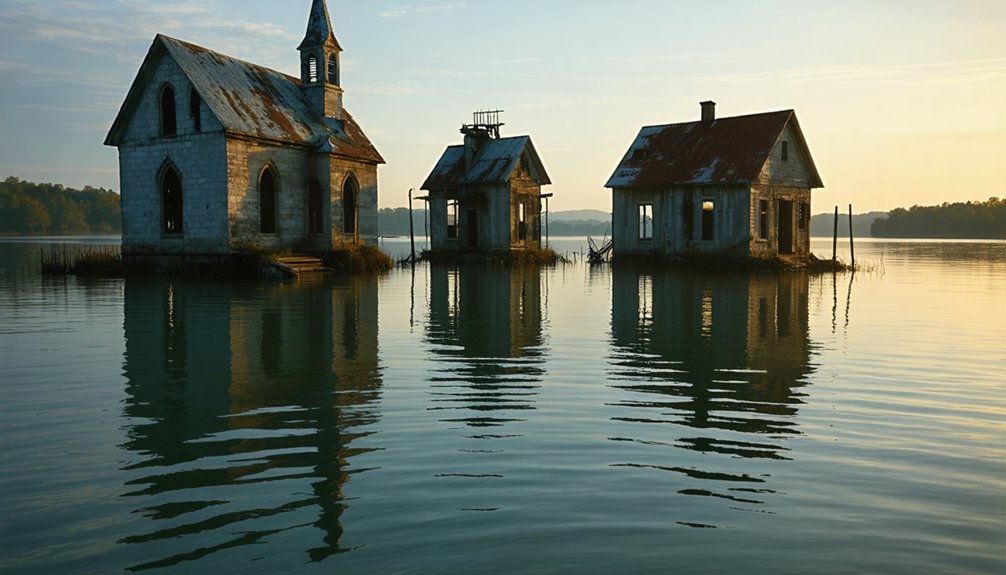
Deep beneath Brownlee Reservoir‘s surface lies Robinette, a once-thriving riverside community that succumbed to rising waters in 1958 when Idaho Power Company completed its 420-foot concrete arch dam.
You’ll find Robinette’s architecture now rests under 100 feet of water, making it one of Oregon’s most notable submerged ghost towns.
Before its inundation, you could’ve witnessed a vibrant settlement featuring a distinctive Quonset hut tavern, train depot, and one-room schoolhouse.
Once-bustling Robinette boasted the simple pleasures of small-town life: a curved-roof tavern, railway station, and modest schoolhouse.
The town’s submerged history includes orchards of peaches, apricots, and walnuts that once lined the Snake River’s banks.
The bustling community served as a key location for Standard Oil operations in the region.
While wooden structures were dismantled or burned, concrete foundations still remain on the reservoir floor, preserving traces of this former Oregon Trail stop and railroad hub beneath the depths of Brownlee’s waters.
The small community, with a population of just 46 residents in 1940, exemplified the tight-knit nature of rural Oregon towns before the dam’s construction.
Beneath the Ashokan: New York’s Submerged Mountain Communities
You’ll find the poignant accounts of displaced Ashokan Valley families who, between 1907-1915, had mere months to bid farewell to their ancestral homes, farms, and communities before the waters rose.
The flooding submerged not only 500 houses and 10 churches but also numerous cemeteries, requiring the relocation of over 2,500 bodies from their original resting places.
Local historians like Vera Sickler documented the lasting resentment towards NYC authorities.
The construction created a thirteen-square-mile reservoir that permanently altered the landscape of the Catskills watershed.
As displaced residents scattered across New York state with often inadequate compensation, they faced the challenging task of rebuilding their lives while their former mountain communities transformed into an essential water supply for New York City.
Displaced Families’ Final Goodbyes
Between 1907 and 1911, thousands of families from four tight-knit hamlets and eight neighboring communities faced a devastating ultimatum as New York City’s water infrastructure expanded into their valley.
You’d find residents hastily packing generations of memories, given mere months to evacuate their ancestral homes. Their final farewells included watching churches, schools, and blacksmith shops dismantled, while 2,500 graves of loved ones were exhumed at $15 per burial.
The displacement hit immigrant, African American, and Native American communities particularly hard. The construction created new job opportunities for some of the displaced workers.
You’ll understand their anguish – these weren’t just buildings being abandoned, but entire social structures dissolving. Emotional closures proved difficult as families received inadequate compensation for their losses, while their farms, businesses, and community centers vanished beneath rising waters. Today, when water levels drop unusually low, visitors can still glimpse the haunting remnants of buildings from these lost communities.
Sacred Sites Underwater Today
While New York City’s 8,315-acre Ashokan Reservoir supplies 40% of the metropolis’s water today, beneath its surface lie the remnants of eight once-thriving hamlets.
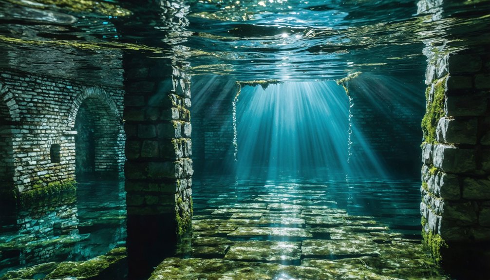
You’ll find submerged legacies of these communities in the form of stone foundations, walls, and other structural remains that occasionally emerge when water levels drop. The forgotten histories include sacred spaces – ten churches and numerous cemeteries that required the relocation of 2,500 bodies.
These underwater ruins tell a story of sacrifice, as communities established since the 1700s were forced to abandon their homes and holy grounds. The displacement affected diverse immigrant populations including Italian and Eastern European settlers who had built lives in these valleys. While memorial signs now mark original town locations along the reservoir’s perimeter, the physical evidence of these displaced communities remains largely hidden beneath the waters, with access to these submerged sites restricted since 2001.
Rebuilding Lives After Relocation
As the Ashokan Reservoir project forced thousands from their homes between 1907-1915, displaced residents faced the challenging task of rebuilding their lives with limited compensation and time.
You’ll find evidence of community resilience in how some towns, like West Hurley and Shokan, managed to relocate and rebuild nearby, while others vanished beneath the waters forever.
The stark reality of cultural preservation emerged as families scrambled to salvage what they could, with compensation often falling short of true property values.
You’re looking at the loss of ten churches, ten schools, and countless businesses that formed the backbone of these communities.
Within just two months, some residents had to uproot generations of history, relocate over 2,500 graves, and start anew – forever changing the social fabric of Ulster County.
St. Thomas: The Desert Town That Lake Mead Swallowed
Once a thriving agricultural settlement established by Mormon pioneers in 1865, St. Thomas exemplifies both sunken history and community resilience.
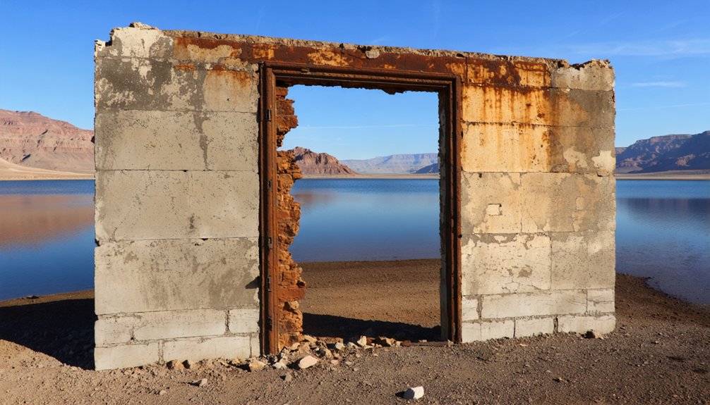
You’ll find its story intertwined with the construction of Hoover Dam, which created Lake Mead and ultimately sealed the town’s fate. The town reached its peak of 500 residents before its inevitable submersion. By 1938, the rising waters had submerged St. Thomas under 60 feet of water, forcing residents to abandon their homes with minimal compensation.
Yet, the town refuses to stay hidden. During periods of drought, particularly since 2002, Lake Mead’s receding waters reveal building foundations, chimney remnants, and roads.
You can now explore these ruins within Lake Mead National Recreation Area, where interpretive trails guide you through the remnants of this once-bustling desert community that served as an essential hub between Los Angeles and Salt Lake City.
Nature’s Fury: River-Claimed Towns Across America
You’ll find America’s waterways have claimed numerous communities through devastating floods and erosion, from the Pacific Northwest’s Robinette to the South’s Washington, Alabama.
Nature’s hydraulic force has permanently altered landscapes, submerging entire towns beneath reservoir waters and forcing populations to rebuild on higher ground.
Throughout the country’s history, you can trace how river paths have reshaped human settlements, leaving a legacy of sunken infrastructure and relocated communities that illustrate our complex relationship with water management.
Devastating Floods Reshape Communities
Throughout American history, devastating floods have permanently altered the landscape of riverside communities, with some towns completely vanishing beneath the waters.
You’ll find stark examples in places like Napoleon, Arkansas, where the Mississippi River completely erased a once-thriving settlement, and Vanport, Oregon, where Columbia River floodwaters obliterated an entire city.
These disasters have triggered massive community displacement effects, forcing planners to reconsider flood resilience strategies.
The toll is staggering: from the 1913 Texas floods that claimed 177 lives and altered the Brazos River’s course, to the 2019 Missouri River flooding that caused $10.8 billion in damage.
Recent climate changes have intensified these risks, with nine of the ten highest single-day rainfall events occurring since 1996.
Nature’s Relentless River Paths
Rivers possess an unrelenting power to reshape landscapes and communities, as evidenced by the dozens of American towns that have vanished beneath their waters.
You’ll find these lost settlements scattered across river ecosystems nationwide, from Napoleon, Arkansas, swallowed by the Mississippi’s changing course, to Washington, Alabama, claimed by persistent flooding.
The historical impacts of these natural transformations have permanently altered local geographies and displaced entire populations.
When you study these river-claimed towns, you’ll discover how nature’s raw force operates independently of human intervention.
The Mississippi River’s path has erased communities through gradual erosion and sudden course changes, while southern towns like Susannah, Alabama, succumbed to the inevitable progression of water’s might, leaving behind only memories of once-thriving settlements.
Historic Towns Lost Forever
While natural river changes have claimed numerous settlements, planned dam construction has permanently erased even more historic American towns.
You’ll find lost heritage beneath reservoirs like Brownlee, where Robinette, Oregon lies 100 feet underwater, its train depot and tavern forever silenced. The flooding of Celilo Falls erased centuries of Native American fishing traditions, while the submerged cultures of communities like Elbowoods, North Dakota vanished beneath the Missouri River.
Detroit, Oregon disappeared under its namesake dam, and American Falls, Idaho relocated entirely before its original site drowned. The story repeats across America’s waterways – from Kennett, California’s gold rush remnants beneath Lake Shasta to the relocated graves of Susannah, Alabama, each submerged town represents a community sacrificed for hydroelectric power and flood control.
The Hidden History of Dam-Created Lakes
During the ambitious dam-building era of the 20th century, hundreds of American communities faced permanent submersion as government agencies constructed massive hydroelectric and flood control projects across the nation’s waterways.
You’ll find this dam history particularly evident along the Snake, Columbia, Missouri, and Willamette Rivers, where entire towns were systematically destroyed before flooding.
The cultural erasure was profound, especially for Native American communities. At Celilo Falls, thousands of years of Indigenous fishing traditions vanished beneath the waters in 1957.
The flooding of Celilo Falls silenced ancient Indigenous rhythms, as millennia of sacred fishing grounds drowned beneath rising waters.
Towns like Elbowoods, North Dakota saw the displacement of entire tribal nations. Before flooding these sites, crews would burn buildings and uproot orchards, erasing all traces of human habitation.
While some communities relocated to higher ground, countless irreplaceable cultural and historical sites now rest eternally beneath America’s reservoir waters.
Frequently Asked Questions
Can You Scuba Dive to Explore These Submerged Towns Today?
You can explore these towns through scuba diving, but you’ll need permits, advanced certifications for deeper sites, and awareness of variable conditions affecting underwater exploration’s safety and visibility.
How Many People Still Live in Areas at Risk of Flooding?
While you might think flood risks are rare, they’re not – over 13.1 million Americans currently live in flood-prone zones, with high population density near major rivers driving continued vulnerability.
What Happened to the Insurance Claims of Displaced Residents?
You’ll find that insurance policy changes often left displaced residents with inadequate compensation, facing bureaucratic hurdles and limited legal recourse when seeking fair payment for their submerged properties and cultural losses.
Are There Any Underwater Preservation Techniques Being Developed?
You’ll find active underwater archaeology preservation methods being developed, including reversible adhesives, controlled desalination tanks, and advanced remote sensing technologies to document and protect submerged artifacts without invasive intervention.
Do Any Ghost Stories or Legends Surround These Submerged Communities?
You’ll find ghostly apparitions and legendary tales surrounding these drowned towns, from Gad’s “Appalachian Atlantis” hauntings to Lake Texoma’s revealed gravestones and Lake Lanier’s stories of cultural erasure.
Explorers and historians alike are drawn to the rich narratives of historic towns in the Pacific Northwest, where remnants of once-thriving communities lie beneath the waters. These submerged sites offer a haunting glimpse into the past, showcasing the intersection of nature and human history. Visiting these locations reveals not just the physical remains but also the stories that shaped the region’s identity.
References
- https://savingplaces.org/stories/facing-flooding-jamestown-archaeologists-are-saving-what-they-can
- https://www.neh.gov/article/atlas-drowned-towns
- https://clui.org/newsletter/spring-2005/immersed-remains-towns-submerged-america
- https://archaeology.org/issues/may-june-2024/letters-from/ghost-towns-of-the-ashokan-reservoir/
- https://www.youtube.com/watch?v=JnIIQymTY3w
- https://en.wikipedia.org/wiki/List_of_flooded_towns_in_the_United_States
- https://www.dhr.virginia.gov/programs/underwater-archaeology/
- https://www.drownedtowns.com
- https://daily.jstor.org/the-river-basin-surveys-preserved-american-prehistory/
- https://www.nationalparkstraveler.org/2025/03/jamestown-drowning