U.S. river ghost towns remain submerged due to the massive dam-building initiatives of the mid-20th century, when over 150 dams transformed America’s waterways into controlled reservoirs. You’ll find these underwater settlements preserved beneath hundreds of feet of water, sacrificed through eminent domain to provide hydroelectric power and stable water supplies for expanding urban areas. While some towns show themselves during extreme droughts, most lie eternally submerged – their foundations holding countless stories of displaced communities and altered landscapes.
Key Takeaways
- Hydroelectric dams remain essential infrastructure for power generation and water management, requiring the continued submersion of towns beneath reservoirs.
- Federal water management policies prioritize urban water supplies and flood control over the preservation of historic river communities.
- The cost and engineering complexity of removing or modifying existing dams makes restoration of submerged towns impractical.
- Reservoirs created by these dams serve vital roles in agricultural irrigation and municipal water supply for millions of Americans.
- Environmental concerns about ecosystem disruption if water levels changed prevent the draining or modification of established reservoirs.
The Rise of Dam Construction in Mid-20th Century America
While early 20th century America relied primarily on fossil fuels for power generation, the advent of large-scale hydroelectric dams marked a revolutionary shift in the nation’s energy landscape.
You’ll find that dam engineering advanced rapidly during the 1930s, with projects like Hoover Dam showcasing unprecedented technical achievements in water management and power generation.
The politics of water rights shaped this era profoundly, as evidenced by the 1922 Colorado River Compact that enabled massive infrastructure development. These transformative water systems now support 40 million people who depend on the Colorado River for their daily needs.
Federal support accelerated dam construction nationwide, particularly in the arid West, where these structures promised freedom from drought and energy scarcity.
Federal investment fueled a dam-building boom across America, as Western states eagerly sought solutions to water shortages and power needs.
Progressive Era reformers championed hydropower as “white coal” – a clean alternative to fossil fuels that could break utility monopolies and democratize access to electricity through rural electrification programs. The Reclamation Bureau and Army Corps of Engineers constructed over 150 dams between 1945 and 1975, fundamentally transforming America’s river systems into energy-generating reservoirs.
From Thriving Communities to Underwater Ruins
You’ll find that many of America’s submerged communities were already experiencing decline before the flood waters rise, with economic shifts and natural disasters accelerating their abandonment.
As dam construction projects advanced, you’d witness entire towns being methodically dismantled – their residents relocated, graves exhumed, and buildings either demolished or transported to higher ground.
Beneath today’s reservoir waters lie the foundations of these lost communities, from Native American settlements to early American towns, their stories preserved only in historical records and the memories of displaced families.
The flooding of Elbowoods forced 325 Native families to relocate, devastating close-knit tribal communities that had existed for generations.
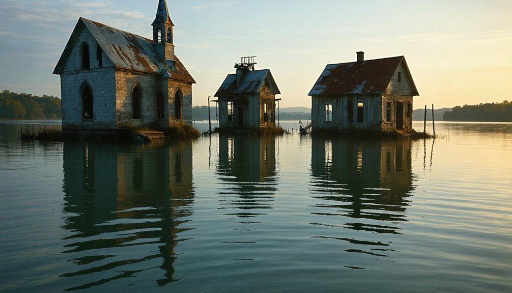
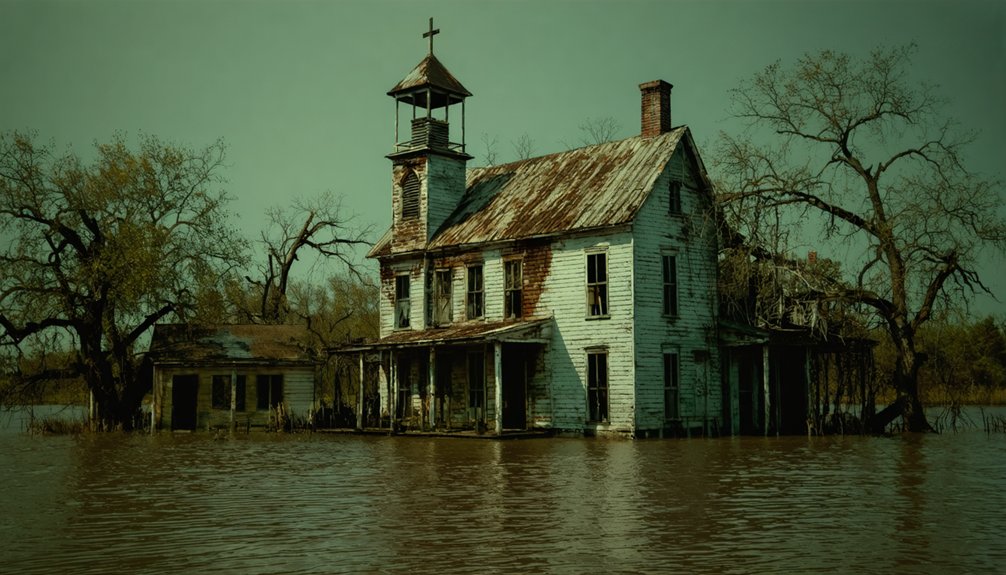
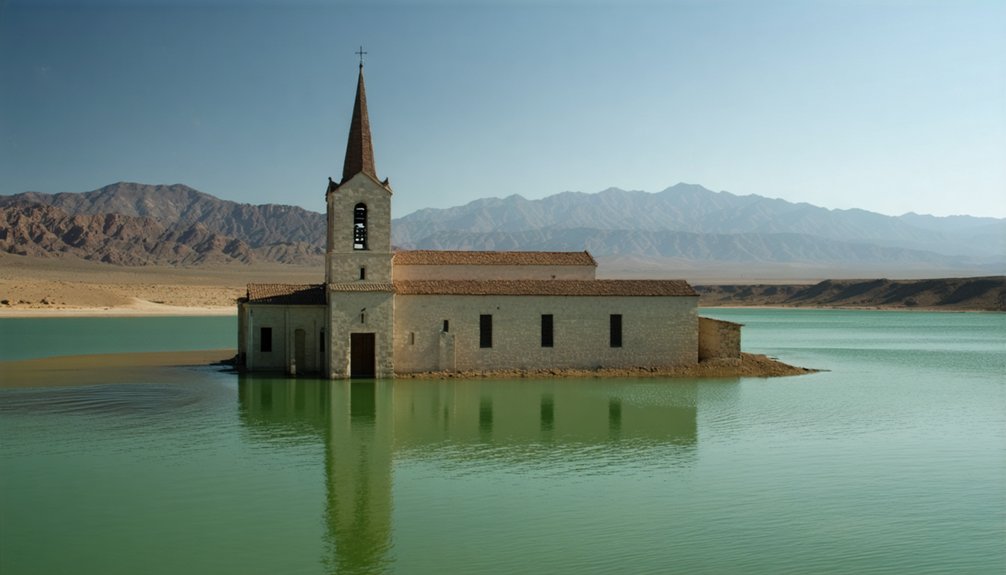
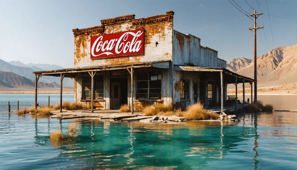
These underwater towns remain largely untouched, though during severe droughts street signs and other remnants become visible, offering glimpses into America’s past.
Among these remnants of abandoned towns in America, the haunting shells of houses stand silent, bearing witness to lives once lived. The stories they tell echo in the wind, inviting those curious enough to explore the forgotten paths of history. Each corner turned may reveal a hidden past, where nature reclaims what was left behind.
Life Before the Floods
Before their inevitable submersion beneath reservoir waters, America’s river ghost towns were vibrant economic hubs that flourished through strategic positioning along major waterways.
As time rolled on, these forgotten towns along American rivers became mere memories, their stories fading into the current. Visitors seeking adventure often find remnants of their architecture and whispered tales of the communities that once thrived in these now-silent areas. The allure of rediscovering the past draws explorers to navigate the waters, unveiling the hidden histories that continue to ripple through the landscapes.
You’d find bustling communities like Preston, Texas, where economic activities centered on cattle drives, stagecoach routes, and river crossings. Towns hosted thousands of residents, with Rodney, Mississippi, reaching 4,000 people at its peak.
These settlements buzzed with community events at local churches, hotels, and racetracks. Cedar Mills thrived with a population of 500 by 1884, attracting commerce from farmers and lumbermen. You could witness industrial prosperity through grain mills, lumber operations, and railroad depots that defined their character.
Even as periodic floods and shifting river channels threatened their existence, these towns maintained vibrant social cores until their final days, with multiple businesses, banks, and social venues serving their populations. The town of Proctor exemplified this resilience, with Moses Proctor’s settlement establishing a strong community that persisted until Fontana Dam’s construction in the 1940s.
Forced Exodus Begins
As massive infrastructure projects reshaped America’s waterways in the mid-20th century, thriving riverside communities faced unprecedented displacement through a combination of government mandates and environmental pressures.
You’ll find displacement narratives revealing how eminent domain claims forced entire towns to relocate, while changing river courses and sediment buildup physically isolated others from essential trade routes. Similar to the 1838 Missouri exodus, many families were coerced to sign over their land to government authorities.
The exodus intensified as economic shifts decimated local industries, particularly in communities dependent on river commerce. Community resilience wavered under the weight of racial tensions and discriminatory practices that complicated recovery efforts. The decline of the cotton trade in Rodney following the Civil War marked a devastating blow to the local economy.
Harsh environmental conditions, including floods and land subsidence, accelerated the departure as infrastructure crumbled. For many towns, the combination of government-mandated evacuations for dam construction and deteriorating economic conditions left residents with no choice but to abandon their homes to rising waters.
Remnants Beneath the Waters
The flooded remnants of America’s displaced riverside communities now rest in aquatic tombs beneath reservoir waters, preserved by the same infrastructure projects that caused their demise.
You’ll find submerged structures like building foundations, roadbeds, and cemetery plots frozen in time, visible only during extreme drawdowns. At places like Fontana Lake and Lake Mead, these ghost towns briefly emerge when water levels plummet, revealing their secrets to underwater archaeology teams.
Below the surface, Native American settlements and pioneer towns create a preserved snapshot of history, though access remains strictly limited. The Keowee Village capital lies hidden beneath Lake Jocassee’s emerald waters, along with numerous other Cherokee historical sites.
While many graves were relocated during the “final harvest” before flooding, some burial grounds still lie undisturbed in their watery graves.
Through sonar and satellite technology, you can now map these submerged communities, their layouts telling stories of America’s drowned past.
At Toledo Bend, double-shotgun homes and farmlands disappeared beneath the waters when the Sabine River was dammed in the 1960s.
Water Management and Urban Development Priorities
While mid-20th century engineering prioritized hydroelectric potential and water security, thousands of riverside communities faced permanent submersion beneath America’s expanding reservoir system.
You’ll find that federal water allocation policies, particularly during the New Deal era, accelerated dam construction with minimal regard for preserving historic settlements. Community displacement became standard practice as planners deemed reservoirs essential for urban expansion and industrial growth.
The strategic benefits of flooding valleys extended beyond power generation. You’re looking at carefully engineered systems that controlled downstream flooding, guaranteed stable urban water supplies, and created predictable river conditions.
These water management priorities reflected an era when eminent domain readily sacrificed small towns for regional development, permanently altering America’s river landscapes to serve expanding metropolitan needs.
Preserving History Beneath the Surface
Beneath America’s vast network of reservoirs lies a complex underwater archive of submerged settlements, where archaeological teams systematically document structural remnants and cultural artifacts before they deteriorate further.
Through historical documentation, you’ll find that low water periods reveal foundations and building ruins, offering glimpses into these lost communities. Local descendants actively participate in community engagement efforts, sharing oral histories and photographs that keep their heritage alive through digital platforms.
You can trace the careful relocation of cemeteries to higher ground, where original layouts are preserved to maintain historical continuity.
During drawdowns, you’ll discover that these submerged towns aren’t forgotten – they’re transformed into underwater time capsules, preserving Native American sites, colonial settlements, and the complex narratives of displacement that shaped America’s waterways.
Lost Native American Lands and Cultural Heritage
Throughout America’s dam-building era, rising waters submerged countless Native American archaeological sites and displaced entire tribal communities, fundamentally altering indigenous landscapes and cultural connections to ancestral territories.
You’ll find stark examples at Fort Berthold Indian Reservation, where Garrison Dam’s waters displaced 80% of tribal members and flooded their ancestral lands beneath Lake Sakakawea.
The cultural erasure continues as Glen Canyon and other dam projects have inundated over 2,000 archaeological sites, including dwellings, petroglyphs, and pottery that held generations of indigenous history.
This ancestral loss extends beyond immediate flooding – drought-lowered water levels now reveal dramatically altered landscapes, while rising seas threaten thousands more coastal sites.
From the Missouri River to Florida’s Gulf Coast, you’re witnessing the ongoing submersion of irreplaceable Native American heritage.
Notable Submerged Towns Across America
When you examine the submerged towns beneath Quabbin Reservoir, you’ll find remnants of four historic Massachusetts communities that were deliberately flooded in the 1930s to create Boston’s water supply.
You can observe similar underwater ghost towns beneath California’s Shasta Lake, where the once-thriving mining community of Kennett disappeared beneath 400 feet of water after the construction of Shasta Dam in 1944.
During severe droughts, you might glimpse the haunting remains of these submerged settlements when reservoir water levels drop considerably, revealing foundations, streets, and other structural remnants that normally rest far below the surface.
Quabbin’s Lost Four Towns
In one of America’s most extensive water infrastructure projects, the creation of Massachusetts’ Quabbin Reservoir submerged four historic towns – Dana, Enfield, Greenwich, and Prescott – beneath 412 billion gallons of water.
The Quabbin history reflects a transformative hydrological undertaking that began in the 1890s, culminating in the town disincorporation at midnight on April 28, 1938. You’ll find the remnants of these communities hidden beneath 39 square miles of carefully engineered waterscape.
Before flooding commenced, crews systematically razed and burned every structure, including 14 mills and railway infrastructure. They exhumed 7,500 bodies from local cemeteries, relocating them to Quabbin Memorial Park.
Today, when water levels drop, you might glimpse traces of foundations, roadways, and occasional tombstones – stark reminders of the communities sacrificed for Boston’s water security.
Shasta Lake’s Drowned Communities
A vast aquatic expanse now conceals the remnants of Kennett, once Northern California’s prominent copper mining boomtown, beneath Shasta Lake’s depths.
You’ll find this submerged history 400 feet underwater, alongside seven other towns and numerous Wintu villages – sacrificed for the 1935 Shasta Dam project. The cultural impact rippled through both settler and indigenous communities, particularly affecting the Winnemem Wintu’s salmon-dependent traditions.
When drought strikes, you might glimpse the skeletal remains of this pre-1944 world: old tunnels, bridges, and train trestles emerging from receding waters.
The Bureau of Reclamation’s strategic flooding, executed without public hearings, transformed thriving communities into underwater artifacts. What was once a bustling hub of saloons, an opera house, and indigenous settlements now serves as a stark reminder of progress’s price.
Environmental and Social Consequences
The submergence of river ghost towns through damming and flooding has triggered cascading environmental and social consequences throughout American watersheds.
When you examine these sites, you’ll find persistent toxic contamination in sediments, including PCBs and dioxins that continue affecting aquatic life. The ecological impact extends beyond water quality – you’re looking at disrupted fish migration patterns, altered downstream temperatures, and permanently modified riparian zones.
You’ll discover that flooding doesn’t just destroy physical structures; it erases community identity. Forced relocations have scattered tight-knit populations, severing generational ties to the land.
While new reservoirs create recreational opportunities, they’ve come at the cost of indigenous heritage sites and historical landmarks. The environmental alterations you’re witnessing today will influence watershed dynamics for generations.
Resurfacing Memories During Drought Periods
Dramatic water level fluctuations during drought periods periodically disclose America’s submerged ghost towns, offering fleeting glimpses into communities long lost beneath reservoir waters.
As reservoirs recede, you’ll witness foundations emerging from the depths, exposing architectural remnants and cultural artifacts typically hidden from view.
These drought impacts create crucial windows for memory preservation, as historians and descendants rush to document resurfaced structures, roads, and cemeteries before waters return.
You’ll find communities gathering to photograph exposed ruins, share oral histories, and study archaeological features that drought has temporarily revealed.
Through social media and historical documentation, you’re able to connect with these submerged histories during these rare exposures, preserving the legacy of towns sacrificed for hydroelectric power and water management infrastructure.
Frequently Asked Questions
Can Divers Legally Explore Submerged Ghost Towns?
You can dive and explore submerged ghost towns under diving regulations, but you’ll need permits for any artifact collection. Most states allow recreational inspection while protecting sites through underwater archaeology laws.
What Happens to Fish Populations Living in Submerged Town Structures?
You’ll find fish darting through sunken windows and doorways, as submerged towns create complex fish habitat networks. The ecological impact transforms these structures into artificial reefs, boosting local populations through increased shelter and food.
Do Insurance Companies Cover Properties That Were Intentionally Submerged?
You won’t find insurance policies covering intentionally submerged properties since standard contracts explicitly exclude deliberate flooding. Your only recourse for government-caused submersion would be inverse condemnation claims for compensation.
How Accurate Are Underwater Mapping Technologies for Documenting Submerged Towns?
You’ll find modern underwater sonar mapping achieves remarkable historical accuracy, detecting structures as small as 5cm in shallow waters, though deep or turbid conditions can limit resolution considerably.
Are There Plans to Drain Any Reservoirs to Reclaim Submerged Towns?
What lies beneath stays beneath. You won’t find active reservoir reclamation plans for submerged infrastructure, as environmental regulations, high costs, and critical water management needs prevent draining projects in U.S. waterways.
References
- https://www.uncharted101.com/the-submerged-towns-of-america/
- https://clui.org/newsletter/spring-2005/immersed-remains-towns-submerged-america
- https://www.thewanderingappalachian.com/post/the-underwater-towns-of-appalachia
- https://cedarbayoumarina.com/four-ghost-towns-under-lake-texoma/
- https://en.wikipedia.org/wiki/List_of_flooded_towns_in_the_United_States
- https://texashighways.com/culture/history/the-lost-underwater-towns-of-texas/
- https://www.wef.org/publications/news/wef-news/ghost-town-emerges-from-the-depths-of-lake-mead/
- https://energyhistory.yale.edu/the-big-dam-era/
- https://www.nps.gov/articles/-the-greatest-dam-in-the-world-building-hoover-dam-teaching-with-historic-places.htm
- https://pmc.ncbi.nlm.nih.gov/articles/PMC8363679/