You’ll find exceptional drone photography opportunities at North Dakota’s most isolated ghost towns, including Alkabo, Lonetree, and Griffin. These abandoned settlements feature historic churches, weathered grain elevators, and forgotten farmsteads that create compelling aerial compositions. Plan your shots during golden hour at sunrise or sunset for dramatic lighting and texture. The Ghosts of North Dakota website provides an interactive map to locate these remote sites, where untold stories of prairie life await above.
Key Takeaways
- Nanson provides unobstructed prairie views without power lines, making it perfect for clear aerial photography shots.
- Griffin features historic Yellowstone Trail markers and abandoned structures within 60 minutes of Minot for convenient access.
- Alkabo offers compelling aerial perspectives due to its extreme isolation and well-preserved architectural remnants.
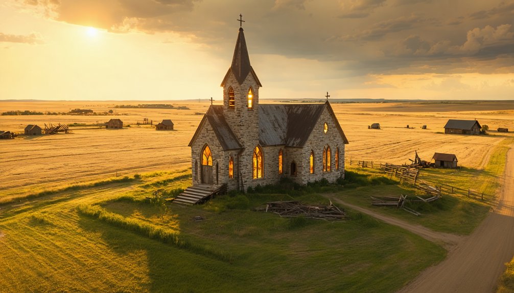
- Sims contains an active Lutheran church amid abandoned buildings, creating dramatic visual contrasts for drone photographers.
- Arena’s St. John’s Lutheran Church and surrounding clustered buildings offer striking architectural compositions from above.
Remote Ghost Towns: Perfect for Aerial Isolation
While North Dakota’s abandoned settlements dot the landscape, several ghost towns stand out for their extreme isolation and drone photography potential.
Scattered across North Dakota’s vast plains, forgotten towns beckon aerial photographers to capture their profound solitude.
Professional photographers guide visitors through these remarkable locations, sharing expert techniques and historical insights. You’ll find Alkabo reduced to a single family, with the North Grand Church offering compelling aerial perspectives.
Lonetree’s fascinating church and complete abandonment create striking compositions from above, while Griffin’s plowed-over remains and scattered artifacts tell a story of pure abandonment since the early 1900s. Hurricane Lake Church, established around 1910 and unused for over 50 years, presents a deteriorating yet photogenic landmark.
Kongsberg’s location near Ruso amplifies its seclusion, making it ideal for drone capture.
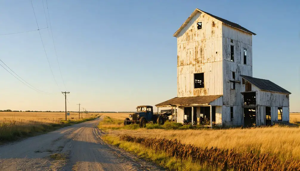
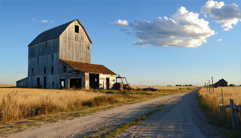
Marmath’s decaying grain elevators and schools, surrounded by pheasant-rich terrain, showcase abandoned beauty hours from civilization.
These remote locations, marked by no trespassing signs, make drone photography the perfect way to document their haunting isolation.
Architectural Remnants and Rural Landscapes
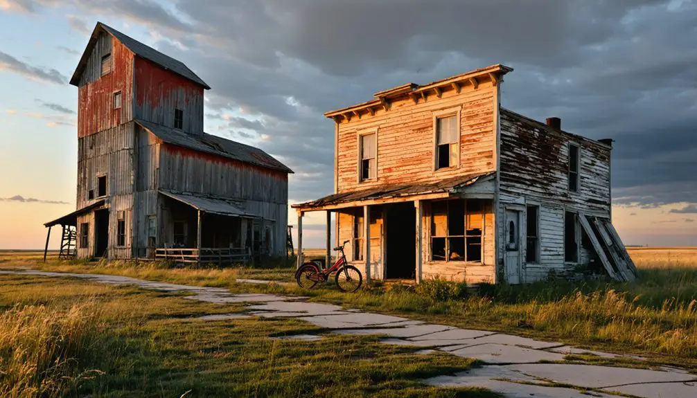
Architectural remnants stand as silent witnesses to North Dakota’s vanished communities, offering drone photographers distinct visual opportunities through their varied structures and forms.
The Yellowstone Trail markers, painted in bright yellow and standing three feet tall, provide fascinating historical waypoints to incorporate into aerial compositions.
A visit to ghost town sites near Minot takes between 30 to 60 minutes of travel time, making them perfect for day-trip photography sessions.
You’ll discover rich possibilities for architectural preservation documentation and rural heritage storytelling through your drone’s lens.
- Churches and their adjacent cemeteries create compelling compositions with weathered steeples, worn paths, and tombstone layouts visible from above.
- Grain elevators stand as monolithic sentinels, their surfaces revealing dramatic textures during golden hour while connecting to abandoned rail lines.
- Schools and civic buildings present symmetrical facades perfect for nadir shots, with foundations revealing hidden town patterns.
- Scattered farmsteads and barns tell intimate stories of agricultural life, their weathered forms creating natural focal points against the prairie landscape.
Your drone flights can capture these disappearing structures while respecting local access and safety considerations.
Best Times and Conditions for Ghost Town Drone Shots
To capture compelling ghost town drone footage, you’ll need to carefully consider both timing and environmental conditions that enhance visual impact. The ideal lighting windows occur during golden hour at sunrise and sunset, offering warm side-lighting that emphasizes texture on weathered structures.
Blue hour provides even, low-contrast scenes perfect for light painting and long exposures.
Seasonal considerations greatly impact your shots. Winter’s low sun creates dramatic silhouettes, while summer requires HDR techniques to manage harsh contrasts. Spring and fall offer varied vegetation colors for dynamic compositions. Having covered over 65,000 miles of North Dakota territory reveals that each season presents unique photographic opportunities. Using Pix4D capture software helps ensure precise flight paths for consistent image collection.
Each season brings unique visual opportunities, from winter’s stark shadows to autumn’s rich palette of surrounding vegetation.
For best results, fly during overcast conditions or after storms when broken clouds create dramatic skies. Keep your drone grounded during precipitation or high winds above 15 mph.
Plan sunrise missions for east-facing facades and sunset flights for backlit architectural features.
For drone photographers seeking abandoned locations in North Dakota, several valuable resources can help pinpoint promising sites across the state.
Begin your exploration strategy by consulting the Ghosts of North Dakota website’s searchable database and interactive map for precise locations and historical significance.
- The ArcGIS Online map shows current ghost town positions across North Dakota, with the most recent updates from 2019.
- You’ll find true ghost towns like Griffin, featuring historic Yellowstone Trail markers and stockyard remains.
- Drive times from Minot to nearby abandoned sites like Tagus and Balfour range from 30-60 minutes.
- Research platforms like Rootsweb catalog over thousand ghost towns in various states of abandonment, helping you plan efficient photography routes.
Due to operational issues affecting the mapping system, be sure to download offline maps before heading out to remote locations.
These resources guarantee you’ll maximize your drone photography sessions while documenting North Dakota’s vanishing heritage.
Top Locations for Capturing Rural Decay From Above
While North Dakota’s vast prairie landscape hosts numerous abandoned settlements, five ghost towns stand out as premier destinations for drone photography: Sims, Arena, Nanson, Charbonneau, and Deisem.
For those looking to capture the stunning night sky, astrophotography tips for North Dakota can greatly enhance your experience. The clear, dark skies provide an excellent backdrop for shooting the Milky Way and capturing celestial events. Make sure to explore the best times of year and ideal locations to set up your shots, ensuring you take full advantage of the beautiful North Dakota landscape.
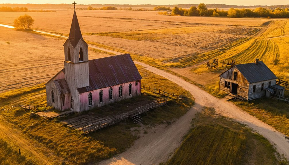
Each location offers unique drone techniques for rural storytelling. Sims features an active Lutheran church amid decay, perfect for capturing dramatic contrasts from above. Originally established as a coal mining town in 1883, Sims provides fascinating glimpses into early industrial history.
Drone photography elevates Sims’ stark narrative, where an active Lutheran church persists among abandoned structures, creating powerful visual contrasts.
Arena’s St. John’s Lutheran Church provides striking religious architecture shots, while its clustered buildings create compelling abandonment patterns.
You’ll find Nanson’s pure isolation ideal for unobstructed prairie views, with no power lines to interfere with your shots.
Charbonneau’s ruins stand starkly against the western landscape near oil country, while Deisem’s hidden structures reveal themselves through aerial perspectives, with its former Seventh Day Adventist Church serving as the primary focal point.
Frequently Asked Questions
Are Permits Required for Drone Photography in These Ghost Towns?
You’ll need FAA Part 107 certification for commercial drone photography, plus landowner permission and specific permits for state historic sites, tribal lands, or controlled airspace locations you’re shooting.
What Wildlife Hazards Should Drone Operators Watch For?
When flying near Grand Forks like the 2015 incident, you’ll need to watch for raptor encounters. Keep scanning for hawks, eagles, and seasonal bird flocks that could damage your drone during operations.
How Stable Are the Structures for Indoor Drone Flights?
You’ll need to carefully assess indoor stability before flight, as most structures are dangerously unstable. Check for sagging floors, cracked walls, and rotted beams to determine drone safety in each room.
Can These Locations Be Accessed During Winter Months?
With 90% of North Dakota’s roads maintained year-round, you’ll find winter accessibility to these towns straightforward. Highway 52 and rural routes remain open, though seasonal considerations include watching weather forecasts for snowstorms.
Are There Any Local Guides Who Specialize in Ghost Town Photography?
You’ll find local photography workshops through Photo Cascadia, led by David Cobb and Christian Heeb, who offer specialized historical town tours. Check Ghosts of North Dakota’s website for additional tour guides.
Explorers looking for unique backdrops should consider visiting abandoned movie sets in North Dakota, where remnants of film history can be discovered. These locations not only provide stunning visuals but also a glimpse into the storytelling that once brought them to life. Whether you’re a photographer or a history buff, these sites offer a fascinating adventure into the cinematic past.
References
- https://ghostsofnorthdakota892857007.wordpress.com/2015/10/30/true-ghost-towns-population-zero/
- https://www.amyallender.com/north-dakota-ghost-towns/
- https://www.photocascadia.com/workshop/ghost-towns-of-north-dakota/
- https://www.youtube.com/watch?v=8GO57Im_dss
- https://us1033.com/a-haunting-look-at-some-real-life-north-dakota-ghost-towns/
- https://www.youtube.com/watch?v=PlkGWkQfFrM
- https://blog.statemuseum.nd.gov/blog/birds-eye-view
- https://www.youtube.com/watch?v=0n3LvrSDRLU
- https://www.youtube.com/watch?v=-E2DA6Ryd1g
- https://aerial.dwr.nd.gov