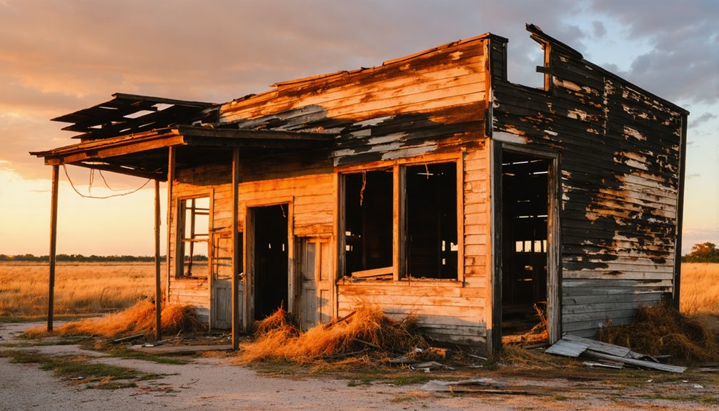
You’ll find Cap Rock nestled in West Texas, where it transformed from vast ranchlands to small farming plots in 1925 under pioneers like C.H. Graham and John Wheeler. The community thrived initially with a cotton gin, store, and one-room schoolhouse serving grades 1-7 until 1960. Transportation challenges, including unpaved roads and no railroad access, coupled with agricultural struggles, led to its decline. The abandoned structures still stand today, holding stories of Texas’s rural past.
Key Takeaways
- Cap Rock transformed from ranchlands to a farming community in 1925 before eventually becoming a ghost town due to economic decline.
- The community’s isolation from railroads and reliance on unpaved dirt roads contributed significantly to its economic downfall.
- Cap Rock’s one-room schoolhouse operated from 1929 to 1960, serving as both an educational facility and community gathering place.
- Agricultural challenges, including water scarcity and soil erosion, forced many residents to relocate, leading to the town’s abandonment.
- Today, Cap Rock retains building remnants and historical structures, attracting history enthusiasts despite having minimal population.
The Birth of a Farming Community
While vast ranchlands dominated the Texas Caprock region in the early 1900s, the area underwent a dramatic transformation in 1925 when large cattle ranches were subdivided into smaller farming plots.
You’ll find settler stories of determined pioneers like C.H. Graham, Lawrence Teston, and John Wheeler, who laid the foundation for Cap Rock’s development by donating land for essential services. These visionaries established the community’s first store, cotton gin, and the Plum Creek School District by 1929. The district’s first educator, Estelle Griffin, began teaching students in a one-room schoolhouse.
Despite the semi-arid climate and rocky terrain, farmers embraced agricultural innovations to overcome nature’s challenges. The innovative spirit was exemplified by C.W. Post’s experiments with rainmaking techniques in the region.
In nearby Garza County, some even attempted dynamite-induced rainmaking. The community’s emergence marked a significant shift from traditional ranching to a diverse economy of small farms and livestock operations.
Life Around the Schoolhouse
As the 1929 spring semester began, Cap Rock’s first one-room schoolhouse opened its doors under the leadership of teacher Estelle Griffin, marking a pivotal moment for this rural farming settlement.
You’ll find the schoolhouse memories deeply woven into Cap Rock’s identity, where pioneer families like the Grahams and Wheelers donated land to build not just a school, but a community’s future.
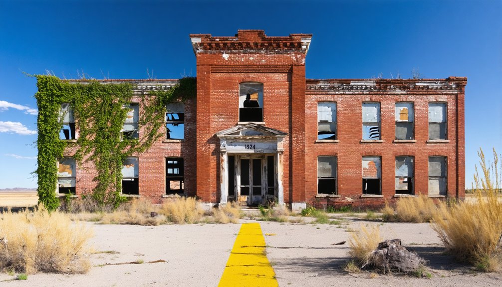
Until its consolidation with Ralls ISD in 1960, the schoolhouse made an educational impact on local children from grades one through seven. The school’s design differed greatly from modern institutions like Caprock High School, which opened in 1963 with multiple buildings and advanced facilities. Similar to Three Way School, they provided housing for teachers to attract qualified educators to the rural location.
For over 30 years, Cap Rock’s one-room schoolhouse nurtured young minds, shaping rural education before joining the larger Ralls school district.
- Pioneer families gathered here for community events beyond daily lessons
- Children walked or rode horses from surrounding farms to attend classes
- Teachers lived on-site, becoming integral parts of the rural community
- The schoolhouse served as an anchor for the area’s 25 residents until 2000
Cotton’s Rise and Fall
Beyond the schoolhouse walls, cotton shaped Cap Rock’s destiny through the late 1800s and early 1900s. You’d have witnessed the surge in cotton production as Texas transformed from modest beginnings of 58,073 bales in 1849 to over 3.5 million bales by 1900.
The region’s story paralleled the state’s cotton boom, particularly after railroads arrived and agricultural innovations took hold. The introduction of automated ginning systems by Robert S. Munger in 1884 revolutionized how cotton was processed across Texas. By 1950, twenty-five counties surrounding Lubbock produced more than half of Texas’ total cotton output.
When ranchers on the High Plains started experimenting with cotton farming, places like Cap Rock found new purpose. The success at Spur Ranch in 1884 proved what was possible on this rugged terrain.
But you couldn’t ignore the challenges – less fertile soil meant lower yields compared to eastern Texas. By the early 1900s, the combination of expanding onto marginal lands and market fragmentation began testing farmers’ resilience.
Ancient Landscapes of the Caprock
Long before Cap Rock became cotton country, dramatic geological forces carved the region’s defining feature – the Caprock Escarpment.
You’re looking at ancient erosion that shaped this land over millions of years, as water and sediment from the Rocky Mountains built layer upon layer across the Great Plains.
The region’s geological heritage is revealed in:
- A protective caliche cap rock rising 1,000 feet above the plains
- Deep canyons exposing 280-million-year-old Permian red beds
- Major rivers like the Red, Brazos, and Colorado cutting through ancient strata
- Complex layers of marine deposits, from limestone to salt domes
Some salt domes in Texas contain remarkable cap rock thickness reaching nearly 900 feet.
Today, you’ll find this rugged landscape continuing to evolve, as wind and water sculpt badlands, arroyos, and canyons. The Ogallala Aquifer springs nourish the surrounding trees and sustain local wildlife.
The escarpment stands as nature’s boundary between the high Llano Estacado plateau and the lower Rolling Plains to the east.
Native American Heritage
The same ancient landscapes that shaped the Caprock’s dramatic geology also drew Native American peoples for thousands of years.
Archaeological research has revealed that Late Archaic hunters relied heavily on bison across the southern High Plains region.
You’ll find evidence of indigenous traditions dating back 12,000 years when Paleo-Indian cultures like the Clovis and Folsom hunted mammoth and bison across these lands. The Comanche later dominated the region, alongside Apache, Kiowa, and Cheyenne tribes who made the canyonlands their home.
The area’s cultural significance is marked by sacred burial cairns along ridgelines and bluffs, while natural springs fed by the Ogallala Aquifer sustained their hunter-gatherer lifestyle. Much like at Hueco Tanks, these natural water sources were crucial gathering places for indigenous peoples.
A vibrant trade network flourished here from the 1700s to 1875, with Comancheros facilitating exchanges between Plains tribes and New Mexican traders until the buffalo’s decline marked the end of this distinctive era.
The Valley Gin Legacy
Pioneering cotton farmers celebrated a major milestone in 1925 when John Wheeler donated land for Cap Rock’s first Valley Gin, establishing what would become the town’s economic heart. The gin operations transformed local agriculture, providing essential cotton processing that fueled the area’s growth from ranchland to farmland.
- You’d find the Valley Gin bustling during harvest seasons, serving as a hub for community gatherings and commerce.
- Local farmers could process their cotton without lengthy travel, boosting the region’s economic viability.
- The facility supported nearby businesses, including Lawrence Teston’s store, creating a vibrant commercial center.
- During the mid-1900s, the gin helped sustain Cap Rock through the Great Depression and post-war changes.
Transportation Challenges
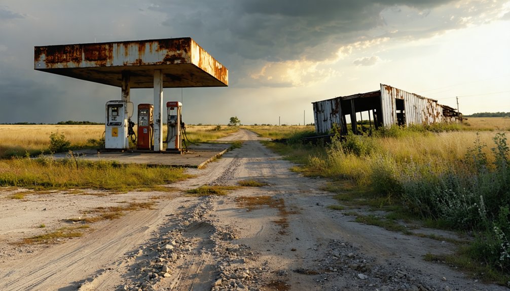
You’ll find Cap Rock’s growth was severely constrained by its reliance on unpaved dirt roads that became treacherous during wet weather, making travel and commerce difficult throughout its history.
While neighboring towns benefited from the Burlington Northern Railway‘s 1928 branch line that navigated the challenging Caprock Escarpment, Cap Rock itself remained disconnected from this crucial transportation link.
The town’s isolation deepened when it was bypassed by major highway development in the mid-20th century, leaving it dependent on farm-to-market roads that couldn’t support significant commercial development.
Dirt Roads Limit Growth
While Cap Rock once held promise for growth and development, its extensive network of unpaved dirt and gravel roads has severely hindered the town’s economic potential.
Limited road maintenance and poor vehicle accessibility have created significant barriers for both residents and businesses trying to thrive in this rugged Texas landscape.
You’ll find these critical limitations throughout Cap Rock:
- Seasonal weather renders many roads impassable, disrupting essential supply deliveries and emergency services
- Commercial trucks struggle to transport agricultural products to market, stifling local business growth
- Only high-clearance and 4×4 vehicles can safely navigate the rough terrain, especially near Caprock Canyons
- Tourism potential remains untapped as standard vehicles can’t reach many scenic areas and camping spots
These transportation challenges continue to isolate Cap Rock from economic opportunities and regional integration.
Railroad Never Arrived
Despite promising plans by the Fort Worth & Denver South Plains Railway to extend feeder lines south of Estelline in the late 1800s, Cap Rock never secured the essential rail connection it desperately needed.
The railroad’s impact on the region was stark – while nearby rail-served towns flourished, Cap Rock suffered from economic isolation that would ultimately seal its fate.
You’d have seen the effects of this missing infrastructure in every aspect of local life. Farmers and ranchers couldn’t efficiently ship their cattle or crops to broader markets, facing higher transportation costs and limited distribution options.
When Burlington Northern abandoned their nearby branch line in 1989, it only worsened the situation. Without the critical rail links that other Texas towns enjoyed, Cap Rock’s dreams of growth and prosperity gradually faded into ghost town status.
Isolation From Major Highways
Located far from any major thoroughfares, Cap Rock’s isolation from highway networks severely limited its development potential throughout the 20th century.
The lack of road development left visitors and residents traversing a maze of unpaved county and farm-to-market roads, often challenging your transportation strategies when traveling to and from the area.
- You’ll find yourself miles from the nearest state highway, facing poorly maintained dirt roads that become treacherous during wet weather.
- Emergency services can’t reach you quickly, with response times stretched by the remote location.
- You’re looking at significant travel time to reach basic amenities or services.
- Getting your agricultural products to market costs more due to the limited infrastructure.
The area’s economic growth suffered as businesses and potential residents avoided settling in a location so disconnected from Texas’s main transportation arteries.
School District Consolidation
You’ll find Cap Rock’s schoolhouse integration into larger districts mirrored the broader 1930s Texas consolidation movement, which transformed rural education by merging one-room schools into centralized campuses.
The weathered Cap Rock school building, once bustling with local farm children, stood empty after 1937 when students began attending classes in neighboring communities’ modernized facilities.
This shift marked not just the building’s end but also accelerated Cap Rock’s identity erosion as families increasingly oriented their daily lives around other towns’ educational and social centers.
Rural Education Changes
While small rural schools once dotted the landscape around Cap Rock, Texas’s major consolidation efforts in the 1930s and post-1949 Gilmer-Aikin laws dramatically transformed local education.
You’ll find that rural education underwent significant changes as districts merged to improve efficiency and expand opportunities. The transformation of local schooling brought both benefits and challenges to your community.
- Three Way Independent School District formed in 1945, combining Goodland, Watson, and Wilson districts across 352 square miles
- Larger consolidated districts offered specialized teachers and broader curriculum choices
- Students faced longer travel distances to reach centralized schools
- Local communities sometimes struggled with the loss of their neighborhood schools
The consolidation movement forever changed the fabric of rural education around Cap Rock, trading small, intimate classrooms for more extensive educational resources.
School Building’s Final Days
After serving the community for over three decades, Cap Rock’s one-room schoolhouse closed its doors on August 23, 1960, when the district consolidated with Ralls Independent School District.
The school closure marked the end of an era for local families who’d sent their children to learn reading, writing, and arithmetic in grades 1-7 within those familiar walls.
Like many rural Texas schools affected by consolidation during this period, Cap Rock’s building faced abandonment or repurposing.
You’ll find similar stories across the region, where only cement slabs remain as silent reminders to these bygone educational hubs.
The educational impact rippled through the community as students shifted to Ralls ISD, gaining access to expanded resources but losing their neighborhood school – a pattern repeated throughout Texas during the mid-20th century consolidation movement.
Community Identity Loss
Despite the intended benefits of broader educational opportunities, Cap Rock’s consolidation into Ralls ISD in 1960 marked a turning point in the community’s collective identity.
You’ll find this pattern repeated across Texas’s rural landscape, where community pride diminished as local schools merged into larger districts.
- Your grandparents’ generation watched as treasured school traditions and mascots disappeared
- You’d no longer see neighbors gathering for Friday night games at the local field
- Your children now faced longer bus rides to centralized campuses
- Your community lost its primary gathering place and social anchor
This identity erosion mirrors what happened throughout the region during the major consolidation waves of the 1930s-1960s, when hundreds of small Texas communities saw their independent districts absorbed into larger administrative units.
The Path to Abandonment
Before Cap Rock’s eventual abandonment, a series of interconnected challenges sealed the settlement’s fate.
You’d have found settlement patterns shifting dramatically after the Valley Gin’s closure in the late 1950s, which had processed over 2,000 cotton bales annually during its peak.
The community’s agricultural sustainability took multiple hits: water scarcity plagued farmers who initially hauled from the Salt Fork Brazos River, while soil erosion undermined crop yields.
Without paved roads connecting to major highways, you couldn’t effectively transport goods or access essential services.
When local leaders’ 1953 proposal for improved roads failed, it dealt a crushing blow to the community’s future.
Residents gradually relocated to better-connected towns, leaving Cap Rock to fade into Texas history.
Frequently Asked Questions
What Natural Wildlife Can Still Be Found in Cap Rock Today?
You’ll spot diverse wildlife sightings including bison herds, coyotes, bobcats, golden eagles, and prairie dogs, alongside local flora like mesquite and cacti thriving throughout Cap Rock’s rugged terrain.
Are There Any Remaining Structures or Ruins in Cap Rock?
You’ll find scattered roofless building ruins and deteriorating foundations throughout the site, though few remaining buildings still stand. Time and weather have left only fragmented historical artifacts to discover.
Do Any Descendants of Original Cap Rock Families Still Live Nearby?
While you’ll find some descendants of early Cap Rock families in nearby towns like Levelland and Morton, direct local heritage has largely dispersed as families relocated during economic shifts throughout the region.
What Was the Highest Recorded Population in Cap Rock’s History?
Time has a way of fading memories. You won’t find official peak population records, but historical significance suggests around 75-100 residents in the late 1920s before population decline began.
Can Visitors Legally Explore the Abandoned Town Site?
You can’t legally explore without landowner permission since the ghost town’s on private property. Local regulations require explicit consent for visitor safety and to avoid trespassing violations on private ranchlands.
References
- https://kids.kiddle.co/Canyon_Valley
- https://www.marfapublicradio.org/show/nature-notes/2017-08-24/caprock-canyons-state-park-the-west-texas-plains-as-they-were
- https://tpwd.texas.gov/state-parks/caprock-canyons/history
- https://www.tshaonline.org/handbook/entries/caprock
- https://www.tshaonline.org/handbook/entries/cap-rock-tx
- https://www.youtube.com/watch?v=qZGIh6S1RwU
- https://texashighways.com/travel-news/the-big-empty-texas-panhandle-region-caprock-canyons-copper-breaks/
- https://www.lubbockonline.com/story/news/history/2021/12/05/caprock-chronicles-tascosa-toughest-town-wild-west-part-two/6275439001/
- https://en.wikipedia.org/wiki/List_of_ghost_towns_in_Texas
- https://www.ultraexpeditions.com/post/2017/02/10/coming-full-circle-the-history-of-caprock-canyons-state-park


