You’ll discover Charbonneau nestled in McKenzie County, North Dakota, where it emerged in 1913 alongside the Great Northern Railroad’s expansion. Named after French-Canadian fur trapper Toussaint Charbonneau, this once-bustling community peaked at 125 residents by 1920, supporting grain elevators, a post office, and a two-room schoolhouse. Today, you can explore its weathered remnants, including two grain elevators and scattered building foundations that whisper stories of its railroad glory days.
Key Takeaways
- Established in 1913 alongside the Great Northern Railroad, Charbonneau peaked at 125 residents in 1920 before declining into a ghost town.
- Named after fur trapper Toussaint Charbonneau, the town served as a vital agricultural hub with grain elevators and railroad facilities.
- Two historic grain elevators, a two-room schoolhouse, and the postmaster’s house remain as primary structures in the abandoned town.
- The town’s decline began with the removal of railroad tracks, leading to business closures and the post office’s shutdown in the 1960s.
- Located in McKenzie County, North Dakota, the site features visible foundations along the former main street and a hilltop cemetery.
The Birth of a Railroad Town
When the Great Northern Railroad constructed a bridge over the Yellowstone River in 1913, the town of Charbonneau sprang to life along its tracks in western North Dakota.
You’ll find it was part of the railroad’s ambitious westward expansion that transformed McKenzie County from an isolated frontier into a connected settlement. The railroad’s influence quickly attracted pioneering spirits who established essential services like a post office, depot, and grain elevator. The town was named after the nearby Charbonneau Creek, honoring the French-Canadian fur trapper who once explored these lands.
Before the railroad’s arrival, you’d have struggled with limited river and overland travel options.
But once the tracks were laid, Charbonneau’s community dynamics flourished. By 1920, you’d have found yourself among 125 residents enjoying multiple grocery stores, a bank, a newspaper, and the county’s first creamery. The town’s main street featured a dirt road with ditches designed to manage heavy rainfall.
The town embodied the freedom and opportunity that railroad connectivity promised to early settlers.
Origins Behind the Name
You’ll find Charbonneau’s name has deep historical roots, originating from nearby Charbonneau Creek, which honors Toussaint Charbonneau, a French-Canadian interpreter for the Lewis and Clark expedition.
While the railroad’s arrival in 1913 established the town’s physical presence, the creek’s name had already marked this land on maps, connecting to the legacy of western exploration. Like many sites bearing the Charbonneau name, it required proper disambiguation to distinguish it from other locations.
The naming choice united the community’s railroad origins with the area’s rich exploration history, particularly through Charbonneau’s role in the famous expedition alongside his wife Sacagawea. The town reached its peak with 125 residents in 1920, marking a brief but notable period of growth in its early years.
Lewis & Clark Connection
The historic ghost town of Charbonneau owes its name to Toussaint Charbonneau, a French-Canadian fur trader and interpreter who played an important role in the Lewis and Clark expedition of 1804-1806. Born in Boucherville, Québec around 1759, he would later become a significant figure in American exploration history.
You’ll find his legacy deeply woven into the region’s history, as he and his family lived at nearby Fort Mandan during the expedition’s significant staging period. While skilled in translation, he was considered a most timid waterman by Lewis due to his poor boat handling abilities.
The Charbonneau legacy extends beyond mere interpretation services. His expedition impact included crucial negotiations with Native tribes, horse trading, and culinary contributions like his famous “boudin blanc” sausage.
With his Shoshone wife Sacagawea and their son Jean Baptiste, born at Fort Mandan in 1805, Charbonneau helped bridge cultural gaps that proved important to the expedition’s success, earning him $500.33, a horse, and lodge for his nineteen months of service.
Railroad Town Establishment
Founded in 1913 as part of the Great Northern Railroad‘s westward expansion, Charbonneau emerged alongside the newly constructed Yellowstone River bridge.
As railroad expansion swept across western North Dakota, this small community quickly established itself as a crucial hub for the surrounding agricultural region. You’d have found essential infrastructure taking shape, including a bustling grain elevator, depot, and post office – often operated by dedicated local families.
The town’s economic impact grew steadily as businesses sprouted up to serve the railway community.
Local Creek Naming Legacy
While exploring Charbonneau’s history, you’ll discover its name originated from Toussaint Charbonneau, a French-Canadian interpreter who served with the Lewis and Clark Expedition in the early 1800s. The creek’s significance stems from the expedition’s camp near its mouth on August 2, 1806, marking it as a site of historical importance.
The naming history reflects Charbonneau’s essential role as an interpreter and cultural bridge between European-American explorers and Native tribes. Despite Lewis’s criticism of his character, Charbonneau’s connections to the Hidatsa and Shoshone through marriage proved invaluable. During their time at Fort Mandan, the expedition relied heavily on Charbonneau’s translation skills while trading with local tribes for essential supplies.
The creek’s name predates the town’s establishment and represents the blending of European fur trader heritage with indigenous influences. You’ll find this legacy preserved in the regional landscape, where the creek continues to serve as a geographic marker of early American exploration.
Life in Early Charbonneau
During its early years, Charbonneau flourished as a close-knit farming community where wooden buildings housed essential services under shared roofs.
You’d find families managing multiple operations, like the post office, depot, and grain elevator, all while living in the same building. Community interactions centered around these hubs, where you could:
- Make calls on the crank wall phone at the post office
- Share late-night meals at the local café
- Pick up farm equipment at the John Deere dealership
- Process dairy at McKenzie County’s first creamery
Early education started in a one-room schoolhouse, later expanding to two rooms in the 1940s as more families settled in.
Like many prairie towns, education grew alongside the community, from humble one-room beginnings to a two-room schoolhouse serving local families.
The town sustained itself through farming, ranching, and local businesses, with services ranging from blacksmith shops to grocery stores, creating a self-sufficient prairie lifestyle. The Homestead laws of 1862 helped establish many of the original farming families in the area.
Peak Years and Population Growth
As the Great Northern Railroad brought increased commerce and connectivity to the region, Charbonneau experienced steady growth that culminated in a peak population of 125 residents by 1920.
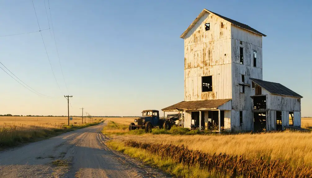
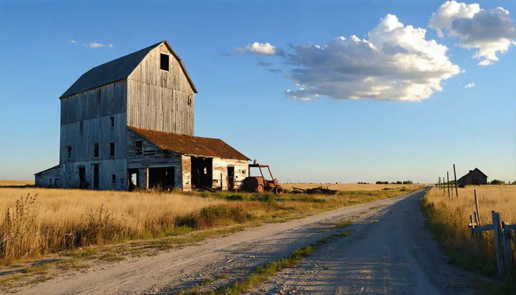
You’d find a bustling agricultural economy centered around the grain elevators, where local farmers brought their harvests for storage and shipment along the railway. Today, these grain elevators still stand as silent sentinels of the town’s past.
The community dynamics revolved around the town’s main institutions: a two-room schoolhouse for local children, a post office that kept everyone connected, and a bank that served the financial needs of residents.
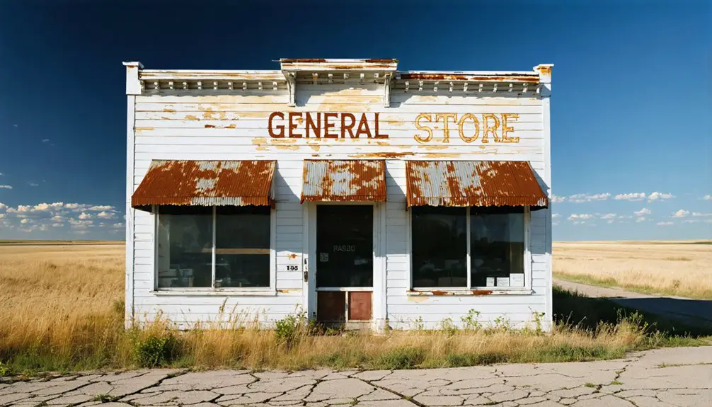
You could stop by the general store for supplies or spend the night at the local hotel.
While Charbonneau never grew beyond 150 residents, it thrived as a typical frontier railroad town, serving the needs of farmers and ranchers throughout the area.
The Town’s Physical Layout
Located on a prominent hill in northwestern McKenzie County, Charbonneau’s physical layout reflected its identity as a frontier railroad town.
You’ll find the town’s street drainage was cleverly designed with deep ditches flanking the main dirt road, protecting buildings from flooding during rain and spring thaws.
The town’s practical layout included:
- A central main street running south from the post office up the hill
- Strategic positioning of the depot and telegraph services along the Great Northern Railroad tracks
- Grain elevators positioned across from the depot for efficient agricultural transport
- A hilltop cemetery offering a peaceful overlook at the northern approach
At 2,047 feet above sea level, you can explore the remaining structures spread along the former railroad line, including the two-room schoolhouse and two residential buildings that still stand today. The town has been largely deserted since the post office closed over 60 years ago.
Notable Buildings and Landmarks
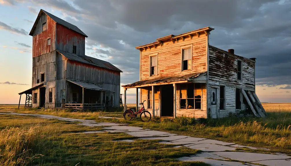
While many of Charbonneau’s original structures have succumbed to time, several notable buildings still stand as silent witnesses to the town’s frontier past.
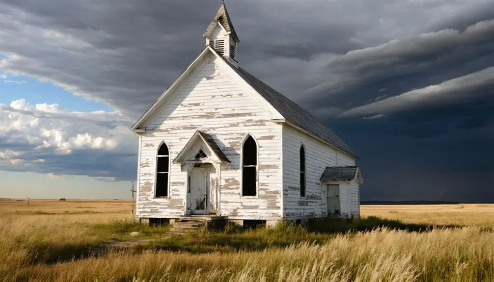
You’ll find the two-room schoolhouse, though its ceiling shows signs of crumbling, and the postmaster’s house remains intact near where the post office once operated.
Two residential homes have survived, with one preserving its original interior.
Among the most prominent historical markers, you’ll spot a couple of grain elevators in recognizable condition.
These notable structures cluster near where the railroad tracks once ran, alongside the town’s main dirt road that climbs the hill.
While the bank, hotel, and general store have vanished, their former locations along the hillside road help map out Charbonneau’s commercial heritage.
The Gradual Decline
From its hopeful beginnings in 1913 to a bustling community of 125 residents by 1920, Charbonneau’s decline unfolded steadily through the mid-20th century.
Like many frontier towns of its era, Charbonneau rose swiftly but faded slowly, its promise dimming with each passing decade.
Economic shifts and changing transportation patterns gradually eroded the town’s liveliness, leading to its eventual abandonment.
You can trace the town’s descent through these key developments:
- The removal of railroad tracks and depot services crippled local commerce.
- Closure of essential businesses like the general store, bank, and hotel.
- Loss of the post office in the 1960s, which devastated community cohesion.
- Removal from Census records by 1960 due to significant population loss.
Without paved roads and with agricultural facilities proving insufficient to sustain growth, residents relocated to nearby towns like Alexander and Watford City, where services and opportunities beckoned.
Present-Day Remnants
If you visit Charbonneau today, you’ll see two commanding grain elevators standing as the most prominent vestiges of this once-thriving farming community.
The old two-room schoolhouse and postmaster’s residence remain, though both structures show decades of weathering from harsh prairie conditions.
Along the town’s former main street, only building foundations and drainage ditches hint at the bustling life that once animated this rural settlement.
Standing Structures Today
Although time has taken its toll on Charbonneau, several original structures still stand as silent witnesses to the town’s past. The remaining buildings, while deteriorating from years of exposure, maintain enough structural integrity to paint a picture of this once-thriving community.
Today, you’ll find these notable structures in Charbonneau:
- A two-room schoolhouse with crumbling ceilings but intact interior framework
- Two grain elevators that have weathered decades of abandonment remarkably well
- The postmaster’s house, now marked with “no trespassing” signs
- A few scattered residential homes in various states of decay
The town’s layout remains visible through its hilltop position and distinctive drainage ditches along the main dirt road, though the railroad tracks and commercial buildings have long since vanished.
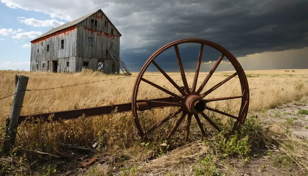
Haunting Rural Decay
The haunting remnants of Charbonneau tell a poignant story of rural decay since its abandonment in the 1960s. If you’re drawn to urban exploration, you’ll find deep ditches along the dirt main street and weathered grain elevators standing sentinel over empty railroad beds.
The school’s crumbling ceiling and scattered interior artifacts create an eerie atmosphere that beckons nostalgia tourism enthusiasts.
You can trace the town’s final days through its economic collapse, marked by the closure of the post office and removal of crucial railroad tracks. The hilltop cemetery remains one of the few well-preserved features, its grave markers quietly overlooking the deteriorating structures below.
Nature steadily reclaims this remote McKenzie County settlement, where harsh North Dakota weather continues to reshape what humans left behind.
Historical Significance in North Dakota
Founded in 1913, Charbonneau emerged as a significant railroad settlement during North Dakota’s early 20th-century expansion, representing an important chapter in the state’s transportation and economic development.
You’ll find Charbonneau’s cultural heritage deeply rooted in the region’s pioneering spirit, named after Toussaint Charbonneau of the Lewis & Clark expedition.
The town’s economic impact extended beyond its modest size, serving as a crucial hub for:
- Agricultural commerce through its grain elevators
- Transportation via the Great Northern Railroad
- Communication services with its telegraph depot
- Key trade through its bank and general store
Though now abandoned, Charbonneau stands as a symbol of North Dakota’s railroad era, when small communities formed the backbone of the state’s development, shaping the cultural and economic landscape we see today.
Frequently Asked Questions
Are There Any Paranormal Activities Reported in the Abandoned Buildings?
You won’t find documented ghost sightings or paranormal investigations in these buildings. Despite the town’s abandonment since the 1960s, there’s no credible evidence of supernatural activity in local records.
The history of Bently ghost town reveals that its decline was primarily due to economic factors rather than mystical occurrences. Many former residents have shared stories of their everyday lives, offering a glimpse into the once-thriving community. While the allure of ghost towns often lies in their rumored hauntings, Bently’s story is more about its inevitable fade into obscurity.
Can Visitors Legally Explore and Photograph the Remaining Structures?
While you’re free to explore this ghost town, you’ll need landowner permission for legal access. Your photography guidelines should include respecting private property and avoiding deteriorating structures that could collapse.
What Happened to the Residents Who Left Charbonneau?
You’ll find most former residents relocated to nearby towns like Watford City and Williston during the 1960s, seeking better economic opportunities after Charbonneau’s post office closed and railroad service ended.
Is the Cemetery Still Maintained, and Are Burials Still Permitted?
You’ll find limited cemetery maintenance through informal efforts by descendants and historians, but there’s no evidence of permitted burials today. Check with tribal or county authorities for current regulations.
Has the Town Ever Been Considered for Historical Preservation or Restoration?
Despite its historical significance as home to Lewis & Clark interpreter Toussaint Charbonneau’s namesake, you won’t find any documented preservation efforts. The town’s structures continue deteriorating, with no active restoration plans in place.
References
- https://ghostsofnorthdakota892857007.wordpress.com/2017/05/20/charbonneau-nd/
- https://writinforthebrand.com/booming-settlement-to-ghost-town-whispers-of-the-living-history-of-charbonneau/
- https://en.wikipedia.org/wiki/Charbonneau
- https://ghostsofnorthdakota892857007.wordpress.com/2017/07/31/charbonneau-a-ghost-town-named-for-a-man-with-no-particular-merit/
- https://kids.kiddle.co/Charbonneau
- https://www.history.nd.gov/hp/PDFinfo/North-Dakota-Railroads-MPDF-Final-corrected.pdf
- https://writinforthebrand.com/the-goose-and-laddie/
- https://www.onlyinyourstate.com/experiences/north-dakota/ghost-towns-nd
- https://en.wikipedia.org/wiki/Toussaint_Charbonneau
- https://lewis-clark.org/members/toussaint-charbonneau/