110 Mile Creek, KS
County:
Zip Code:
Latitude / Longitude:
Elevation:
Time Zone:
Central (CST) (UTC-6)
Established:
Disestablished:
Comments:
Remains:
Current Status:
Remarks:
Abram, KS
County:
Zip Code:
Latitude / Longitude:
Elevation:
Time Zone:
Central (CST) (UTC-6)
Established:
Disestablished:
Comments:
Remains:
Current Status:
Remarks:
Achilles, KS
County:
Rawlins
Zip Code:
Latitude / Longitude:
39°42′13″N 100°48′38″W / 39.70361°N 100.81056°W / 39.70361
Elevation:
2,844 ft (867 m)
Time Zone:
Central (CST) (UTC-6)
Established:
Disestablished:
Comments:
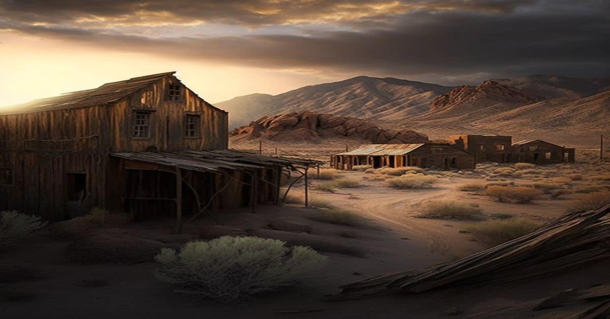
Achilles (/”‘t””l”s/ “-CHIL-“s) is a ghost town in Rawlins County, Kansas, United States. Its heyday began in the 1870s and ended in roughly 1915 when the railroad bypassed Achilles and with more use of the automobile, Achilles declined. Most of the businesses were defunct by the mid- to late-1930s.
Remains:
A post office was opened in Achilles in 1879, and remained in operation until it was discontinued in 1951.
Current Status:
In 1993 Achilles was still marked on Kansas State maps, but by 2001 it was no longer acknowledged on newly published maps.
Remarks:
There were two houses actually in Achilles: Pearl (Hill) and Frank Bacon home and the Fields house. The Fields house remains; the Bacon home was moved. Off of Main Street stood a Methodist church, later moved to Atwood and used for a home. Also off Main Street stood the Achilles one-room schoolhouse, which is still standing and used for community events. Nearby Achilles Cemetery acknowledges many of the pioneers who settled the.
Acres, KS
County:
Zip Code:
Latitude / Longitude:
Elevation:
Time Zone:
Central (CST) (UTC-6)
Established:
Disestablished:
Comments:
Remains:
Current Status:
Remarks:
Afton, KS
County:
Sedgwick
Zip Code:
Latitude / Longitude:
37°36’10″N 97°37’54″W
Elevation:
1,375 ft (419 m)
Time Zone:
Central (CST) (UTC-6)
Established:
Disestablished:
Comments:
Afton Township is a township in Sedgwick County, Kansas, United States.
Remains:
Current Status:
As of the 2000 United States Census, it had a of 1,290.
Remarks:
Agnes City, KS
County:
Lyon
Zip Code:
Latitude / Longitude:
38°39’54″N 96°13’50″W
Elevation:
1,447 ft (441 m)
Time Zone:
Central (CST) (UTC-6)
Established:
Disestablished:
Comments:
Agnes City Township is a township in Lyon County, Kansas, United States.
Remains:
Agnes City Township was founded in 1857.
Current Status:
Remarks:
Alcove Springs, KS
County:
Marshall
Zip Code:
Latitude / Longitude:
39° 44′ 57″ N, 96° 40′ 33″ W
Elevation:
Time Zone:
Central (CST) (UTC-6)
Established:
Disestablished:
Comments:
Alcove Springs was a stop along the Oregon Trail near Independence Crossing in Marshall County, Kansas. Travelers along the trail gave the springs its name. It is located about four miles north of Blue Rapids.
Remains:
Alcove Springs was listed on the National Register of Historic Places in 1972.
Current Status:
Across the road from the Alcove Springs park is another park commemorating the Oregon Trail and features history, wagon swales and a D.A.R. marker memorializing Sarah Keyes, a member of the Donner Party who died in 1846. The exact location of her burial is unknown.
Remarks:
Alexander, KS
County:
Rush
Zip Code:
67513
Latitude / Longitude:
38°28′10″N 99°33′11″W / 38.46944°N 99.55306°W / 38.46944
Elevation:
2,077 ft (633 m)
Time Zone:
Central (CST) (UTC-6)
Established:
1869
Disestablished:
Comments:
Alexander is a city in Rush County, Kansas, United States. As of the 2010 census, the city was 65.
Remains:
Alexander is the oldest city in Rush County, Kansas. It was established in 1869 after becoming an important stopping point on the Fort Hays/Fort Dodge Trail (officially a part of the Santa Fe Trail). The name of the town originated from Alexander Harvey a Scottish emigrant who operated a stockaded trading post on the trail crossing of the Wet Walnut Creek. Havey was a prominent and connected figure in western settlement. He was a friend of renown trapper, trader, and Indian Agent William Bent who established Bent’s Fort in Eastern Colorado. Harvy’s daughter Adaline at age 20 married the 60 year-old Bent.
Current Status:
Today, Alexander’s abandoned three story brick school building is a landmark on K-96 high way. The former Alexander State Bank Building has been re-built and is now the operations and maintenance building for NJR Clean Energy. The community still has the largest grain elevator in Rush County. The elevator is a farmer’s cooperative elevator owned by farmers. Grumbine’s Metal Scrap Yard is the other commercial entity in the community. In 2015, the “Alexander Wind Farm” was constructed south of Alexander. It cost about $85 Million and generates 48 Megawatt of power. The Alexander Wind Farm became commercially operable on January 1, 2016.
Remarks:
In its early days, Alexander was a trading post for trappers, buffalo hunters, wild horse wranglers, and other early Westerners. Buffalo Bill Cody, George Custer, and other prominent figures in American western settlement traveled through the community. Alexander Harvey himself was a former member of the 6th Cavalry. The first post office in Alexander was established in February 1874.
Alida, KS
County:
Zip Code:
Latitude / Longitude:
Elevation:
Time Zone:
Central (CST) (UTC-6)
Established:
Disestablished:
Comments:
Remains:
Current Status:
Remarks:
America City, KS
County:
Zip Code:
Latitude / Longitude:
Elevation:
Time Zone:
Central (CST) (UTC-6)
Established:
Disestablished:
Comments:
Remains:
Current Status:
Remarks:
Amy, KS
County:
Lane
Zip Code:
Latitude / Longitude:
38° 28′ 55″ N, 100° 36′ 7″ W
Elevation:
Time Zone:
Central (CST) (UTC-6)
Established:
Disestablished:
Comments:
Amy is an unincorporated community in Lane County, Kansas, in the United States.
Remains:
Current Status:
Remarks:
Annelly, KS
County:
Harvey
Zip Code:
Latitude / Longitude:
37°58′20″N 97°12′4″W / 37.97222°N 97.20111°W / 37.97222
Elevation:
1,391 ft (424 m)
Time Zone:
Central (CST) (UTC-6)
Established:
Disestablished:
Comments:
Annelly is a ghost town in Richland Township 9 miles southeast of Newton in Harvey County, Kansas, United States. The community was located along the Missouri Pacific Railroad line between Newton and Whitewater, but the track was abandoned in 2003.
Remains:
For many millennia, the Great Plains of North America was inhabited by nomadic Native Americans. From the 16th century to 18th century, the Kingdom of France claimed ownership of large parts of North America. In 1762, after the French and Indian War, France secretly ceded New France to Spain, per the Treaty of Fontainebleau.
Current Status:
In 2003, the railroad track was abandoned. Today only an abandoned 1 room school house and the Main Street (Annelly Road or SE 57th Street, accessible from S East Lake Rd. and SE 60th Street) of Annelly still exist, though the schoolhouse cannot be observed or approached from public roads. A farm house on the west end of Main Street is still occupied. Gypsum Creek, a tributary of the Whitewater River, runs through “downtown” Annelly.
Remarks:
In 1802, Spain returned most of the land to France. In 1803, most of the land for modern day Kansas was acquired by the United States from France as part of the 828,000 square mile Louisiana Purchase for 2.83 cents per acre. In 1854, the Kansas Territory was organized, then in 1861 Kansas became the 34th U.S. state. In 1872, Harvey County was established within the Kansas Territory, which included the land for modern day Annelly.
Arkalon, KS
County:
Seward
Zip Code:
Latitude / Longitude:
37°8’35″N 100°48’27″W
Elevation:
2,618 ft (798 m)
Time Zone:
Central (CST) (UTC-6)
Established:
1888
Disestablished:
Comments:
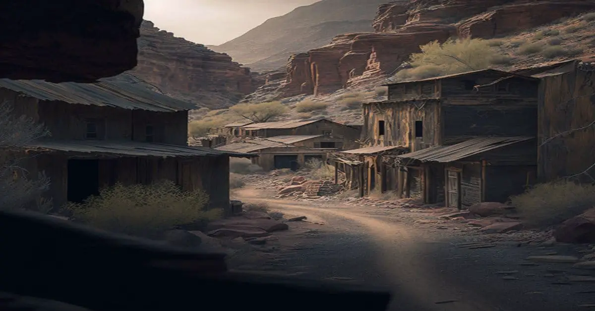
Arkalon is a ghost town in Seward County, Kansas, United States. It was located northeast of Liberal on the west side of the Cimarron River.
Remains:
After the Chicago, Kansas and Nebraska Railway built through the in 1888, a townsite sprang up and platted in 1888. The town was named Arkalon for Arkalon Tenny, the father of the first postmaster of the town. A post office called Arkalon was established in 1888 and remained in operation until 1929.
Current Status:
The Arkalon News newspaper was published from April 1888 until December 1892. In 1891, a one-room school house was opened for children. A large stockyard was erected for shipping cattle to market. While the nearby river held promise for the early settlers, they soon found that the bottom land next the Cimarron River was too sandy for farming and flooded too often. By the 1920s most of the early settlers had left, leaving only the railroad and stockyards behind.
Remarks:
Army City, KS
County:
Zip Code:
Latitude / Longitude:
Elevation:
Time Zone:
Central (CST) (UTC-6)
Established:
Disestablished:
Comments:
Remains:
Current Status:
Remarks:
Arrington, KS
County:
Atchison
Zip Code:
Latitude / Longitude:
39° 27′ 46″ N, 95° 32′ 11″ W
Elevation:
Time Zone:
Central (CST) (UTC-6)
Established:
1884
Disestablished:
Comments:
Arrington is an unincorporated community in Kapioma Township, Atchison County, Kansas, United States.
Remains:
Arrington was platted in 1884.
Current Status:
Remarks:
Arvonia, KS
County:
Zip Code:
Latitude / Longitude:
Elevation:
Time Zone:
Central (CST) (UTC-6)
Established:
Disestablished:
Comments:
Arvonia was settled in 1869, by a company of Welsh people who had formed a colony, with J. Mather Jones as their leader. When the town was started, it was hoped that railroad tracks would be laid along the Marais des Cygnes valley. This failed to happen and the community withered.
Remains:
Current Status:
Once upon a time it had three stores, one hotel, one blacksmith and wagon shop, a post-office, two churches and a schoolhouse. Today, Arvonia is reduced to a few homes and the beautiful stone school.
Remarks:
Ash Point, KS
County:
Zip Code:
Latitude / Longitude:
Elevation:
Time Zone:
Central (CST) (UTC-6)
Established:
Disestablished:
Comments:
Remains:
Current Status:
Remarks:
Ash Valley, KS
County:
Pawnee
Zip Code:
Latitude / Longitude:
38° 18′ 18″ N, 99° 12′ 59″ W
Elevation:
Time Zone:
Central (CST) (UTC-6)
Established:
Disestablished:
Comments:
Ash Valley is an unincorporated community in Pawnee County, Kansas, in the United States.
Remains:
Current Status:
Remarks:
Asherville, KS
County:
Mitchell
Zip Code:
Latitude / Longitude:
39° 24′ 21″ N, 97° 58′ 37″ W
Elevation:
Time Zone:
Central (CST) (UTC-6)
Established:
Disestablished:
Comments:
Asherville is an unincorporated, census-designated place rural in Mitchell County, Kansas, United States.
Remains:
Asherville had the first store (established in 1867) in Mitchell County.
Current Status:
The former post office in Asherville was also the oldest in the county. It opened in 1869, and remained in operation until it was discontinued in 1980.
Remarks:
Ashtabula Colony, KS
County:
Zip Code:
Latitude / Longitude:
Elevation:
Time Zone:
Central (CST) (UTC-6)
Established:
Disestablished:
Comments:
Remains:
Current Status:
Remarks:
Aubry, KS
County:
Johnson
Zip Code:
Latitude / Longitude:
38° 46′ 15″ N, 94° 40′ 16″ W
Elevation:
Time Zone:
Central (CST) (UTC-6)
Established:
1858
Disestablished:
Comments:
Aubry is an unincorporated community in Johnson County, in the U.S. state of Kansas.
Remains:
Aubry Township laid out in 1858. A post office called Aubrey was established in 1860, and remained in operation until it was discontinued in 1888.
Current Status:
Remarks:
Auburndale, KS
County:
Zip Code:
Latitude / Longitude:
Elevation:
Time Zone:
Central (CST) (UTC-6)
Established:
Disestablished:
Comments:
Remains:
Current Status:
Remarks:
Augustine, KS
County:
Zip Code:
Latitude / Longitude:
Elevation:
Time Zone:
Central (CST) (UTC-6)
Established:
Disestablished:
Comments:
Remains:
Current Status:
Remarks:
Bain City, KS
County:
Zip Code:
Latitude / Longitude:
Elevation:
Time Zone:
Central (CST) (UTC-6)
Established:
Disestablished:
Comments:
Fort Bain (also called “Fort Bourbon”) was a log house in the Kansas Territory built in 1857 by John Brown and his associate Captain Oliver P. Bain (or Baynes). The house was located in northern Bourbon County, on the north side of the Osage River 1.5 miles due east of Fort Lincoln, approximately seven miles from the border with Missouri, near the present town of Fulton.
Remains:
The house was used as a rendezvous point for both John Brown and James Montgomery throughout 1857-58 during the Bleeding Kansas troubles, and was also a point on the Underground Railroad. Although no contemporary illustrations or photographs of the house have been located, it was described by Brown as being substantial and capable of housing 50 men.
Current Status:
The house was razed several years after the Bleeding Kansas struggles and replaced with another structure. Nothing marks the site today.
Remarks:
On December 16, 1857, a small number of men who identified themselves as a “Squatter’s Court” defended the house against an armed posse of about 50 men led by United States Deputy Marshal Little from Fort Scott. Upon the arrival of Little’s force, a parley ensued, but ended without resolution. Little advanced on the house and four of his men were wounded. Retreating and regrouping, Little and ten men attempted a second attack on Fort Bain, which was also unsuccessful but without any casualties. Little and his men then returned to Fort Scott. Little returned on December 17 with 150 men and found that Fort Bain had been abandoned by the Free Staters. From Fort Bain, Brown planned his invasion of Missouri in December 1858.
Bala, KS
County:
Riley
Zip Code:
Latitude / Longitude:
39° 18′ 35″ N, 96° 56′ 59″ W
Elevation:
Time Zone:
Central (CST) (UTC-6)
Established:
Disestablished:
Comments:
Bala is an unincorporated community in Bala Township, Riley County, Kansas, United States.
Remains:
Bala settled about 1862. It was a shipping point on the Chicago, Rock Island and Pacific Railroad. It is named after Bala, in Wales.
Current Status:
A post office was opened in Bala in 1871, and remained in operation until it was discontinued in 1966.
Remarks:
Basil, KS
County:
Zip Code:
Latitude / Longitude:
Elevation:
Time Zone:
Central (CST) (UTC-6)
Established:
Disestablished:
Comments:
Remains:
Current Status:
Remarks:
Bassett, KS
County:
Allen
Zip Code:
66749
Latitude / Longitude:
37°54′14″N 95°24′29″W / 37.90389°N 95.40806°W / 37.90389
Elevation:
981 ft (299 m)
Time Zone:
Central (CST) (UTC-6)
Established:
Disestablished:
Comments:
Bassett is a city situated along the Neosho River in the west-central part of Allen County, located in southeast Kansas, in the central United States of America. As of the 2010 census, the city was 14.
Remains:
Bassett was founded in 1903. The following year the Bassett and Concreto extensions were made to the Iola Electric Railroad street car line. In 1914, the first concrete road in Kansas was laid in Bassett.
Current Status:
Remarks:
Bayneville, KS
County:
Sedgwick
Zip Code:
Latitude / Longitude:
37° 33′ 15″ N, 97° 26′ 38″ W
Elevation:
Time Zone:
Central (CST) (UTC-6)
Established:
Disestablished:
Comments:
Bayneville is an unincorporated community in Ohio Township, Sedgwick County, Kansas, USA.
Remains:
Bayneville had its start by the building of the Missouri Pacific Railroad through that territory. It was named for one Judge Bayne, a railroad promoter.
Current Status:
A post office was opened in Bayneville in 1884, and remained in operation until it was discontinued in 1934.
Remarks:
Beach Valley, KS
County:
Zip Code:
Latitude / Longitude:
Elevation:
Time Zone:
Central (CST) (UTC-6)
Established:
Disestablished:
Comments:
Remains:
Current Status:
Remarks:
Beaver, KS
County:
Barton
Zip Code:
Latitude / Longitude:
38°38′24″N 98°40′01″W / 38.64°N 98.667°W / 38.64
Elevation:
1,926 ft (587 m)
Time Zone:
Central (CST) (UTC-6)
Established:
Disestablished:
Comments:
Beaver, Kansas is an unincorporated community in Beaver Township, Barton County, Kansas
Remains:
A post office was opened in Beaver in 1919, and remained in operation until it was discontinued in 1992.
Current Status:
Remarks:
Beersheba, KS
County:
Zip Code:
Latitude / Longitude:
Elevation:
Time Zone:
Central (CST) (UTC-6)
Established:
Disestablished:
Comments:
Remains:
Current Status:
Remarks:
Belmont, KS
County:
Kingman
Zip Code:
Latitude / Longitude:
37°29’15″N 98°11’31″W
Elevation:
1,565 ft (477 m)
Time Zone:
Central (CST) (UTC-6)
Established:
Disestablished:
Comments:
Belmont Township is a township in Kingman County, Kansas, USA.
Remains:
The township contains one cemetery, Cleveland.
Current Status:
As of the 2000 census, its was 92.
Remarks:
Belvidere, KS
County:
Kiowa
Zip Code:
Latitude / Longitude:
37°27′1″N 99°4′48″W / 37.45028°N 99.08000°W / 37.45028
Elevation:
Time Zone:
Central (CST) (UTC-6)
Established:
Disestablished:
Comments:
Belvidere is an unincorporated community located along the Medicine Lodge River in Kiowa County, Kansas, United States.
Remains:
Belvidere was a shipping point on the Atchison, Topeka and Santa Fe Railway. A post office named Glick operated from 1883 until 1890. The Glick post office was renamed Belvidere on April 26, 1890, remained in operation until it was discontinued on November 23, 1996.
Current Status:
In the mid-2000s, Belvidere become the home of a NOAA Weather Radio transmitter, WNG534, operated by the National Weather Service Forecast Office in nearby Dodge City.
Remarks:
Nearby are the Roth Petroglyph Site and the Star Petroglyph Site. Both are on the National Register of Historic Places.
Bendena, KS
County:
Doniphan
Zip Code:
66008
Latitude / Longitude:
39°44′28″N 95°10′46″W / 39.74111°N 95.17944°W / 39.74111
Elevation:
1,112 ft (339 m)
Time Zone:
Central (CST) (UTC-6)
Established:
Disestablished:
Comments:
Bendena is an unincorporated community and census-designated place (CDP) in Doniphan County, Kansas, United States. As of the 2010 census, Bendena had a of 117. Its ZIP Code is 66008.
Remains:
Bendena was founded in 1886. It was originally given the name of “Albers,” after John Albers, who farmed on this land. But when the United States Postal Service established a post office there, they required a change of name because of similarities to other town names in Kansas. It was then named for the sweetheart of the first telegraph operator at the Chicago, Kansas and Nebraska railroad station. The first post office in Bendena was established in January, 1888.
Current Status:
Remarks:
Big Springs, KS
County:
Douglas
Zip Code:
Latitude / Longitude:
39°00′47″N 95°29′06″W / 39.01306°N 95.48500°W / 39.01306
Elevation:
1,102 ft (336 m)
Time Zone:
Central (CST) (UTC-6)
Established:
Disestablished:
Comments:
Big Springs is an unincorporated community in western Douglas County, Kansas, United States. Today it has a water tower, tool shop, church and a fire station that is part of the Lecompton Township Fire Dist. 1. Its mailing address is Lecompton. It is part of USD 450 Shawnee Heights School District in Tecumseh. US Highway 40 runs through the town.
Remains:
The first settlement at Big Springs was made in the fall of 1854. The town was founded by William Harper and John Chamberlain but had always been a popular watering hole along the Oregon Trail. It was named from the mineral springs nearby. On September 5, 1855, Big Springs was home to a free-state convention in which determined men vowed to give their lives to defend their homes from border ruffians from Missouri. The first sermon was preached in 1855 by Reverend W.A. Cardwell in the log home of Ephraim Banning. The first church was built a year later.
Current Status:
In 2010, a building on the east side of town caught fire, leaving a restricted of charred rubble.
Remarks:
Also in 1856, the first post office was established, as well as the first schooling took place then in the town hall. The post office was discontinued in 1903. The did not grow, but hovered around 40 people, as there was no railroad running through the town.
Bigelow, KS
County:
Marshall
Zip Code:
1,175 ft (358 m)
Latitude / Longitude:
39°38′00″N 96°30′16″W / 39.63333°N 96.50444°W / 39.63333
Elevation:
1,175 ft (358 m)
Time Zone:
Central (CST) (UTC-6)
Established:
Disestablished:
Comments:
Bigelow was a town in Marshall County, Kansas. It was located six and a half miles southwest of Frankfort.
Remains:
It was founded in 1881 and named for General Alfred Bigelow. It was known for its limestone quarries and peaked in in 1910 at 200. The post office closed in 1960 and the town was demolished during the construction of Tuttle Creek Lake.
Current Status:
All that remains is a historical marker at the intersection of 17th and Zenith Roads and Antioch Cemetery.
Remarks:
Black Jack, KS
County:
Douglas
Zip Code:
Latitude / Longitude:
38° 46′ 4″ N, 95° 6′ 57″ W
Elevation:
Time Zone:
Central (CST) (UTC-6)
Established:
Disestablished:
Comments:
Black Jack is an unincorporated community in Douglas County, in the U.S. state of Kansas.
Remains:
The Battle of Black Jack was fought near Black Jack Creek in 1856. Black Jack was founded in 1857, and named from nearby Black Jack Creek. The creek was named for the Blackjack Oak trees along its course. A post office was established at Black Jack in 1858, and remained in operation until 1895.
Current Status:
Remarks:
Black Wolf, KS
County:
Ellsworth
Zip Code:
Latitude / Longitude:
38°45′30″N 98°21′43″W / 38.75833°N 98.36194°W / 38.75833
Elevation:
1,565 ft (477 m)
Time Zone:
Central (CST) (UTC-6)
Established:
Disestablished:
Comments:
Black Wolf is an unincorporated community in Ellsworth County, Kansas, United States. It is located approximately 6 miles (9.7 km) west of Ellsworth.
Remains:
A post office was opened in Black Wolf in 1879, closed temporarily in 1908, reopened a few months later and remained in operation until it was discontinued in 1953. According to tradition, “Black Wolf” was the name of a local Indian. Black Wolf was a station on the Union Pacific Railroad.
Current Status:
Remarks:
Blaine, KS
County:
Pottawatomie
Zip Code:
Latitude / Longitude:
39°29′48″N 96°24′11″W / 39.49667°N 96.40306°W / 39.49667
Elevation:
1,506 ft (459 m)
Time Zone:
Central (CST) (UTC-6)
Established:
1873
Disestablished:
Comments:
Blaine is an unincorporated community in Pottawatomie County, Kansas, United States. It is located 29 miles northeast of Manhattan at the crossroads of K-99 and K-16.
Remains:
Many of the first settlers or their family members had originally immigrated to America during the Potato Famine and then slowly moved westward. The immigrants established the settlement of Butler City along Bluff Creek which served as the first settlers’ main water source. Butler City was officially platted at tier 6 south, ranges 9 and 10 east on October 14, 1879; the young town’s namesake was Father Thomas Ambrose Butler, an Irish Priest in St. Louis, who encouraged the original settlers to “colonize” in and around modern day Blaine. The community initially was settled by 60 Irish Catholics families in 1873. The Irish emigrants came from a poor Irish neighborhood of St. Louis known as the “Kerry Patch”. A post office was opened in Butler City in 1874.
Current Status:
Although Irish Catholics made up the majority of Blaine and the surrounding , these people did not exist in cultural isolation. The original Irish settlers in Blaine were joined by a few German families throughout the latter part of the 19th century. At Blaine’s peak, there were approximately 200 people living in the community. Today it is around 30, a majority of whom are the descendants of the original settlers.
Remarks:
Since another town was already named Butler City in Kansas, residents decided to rename the town to Blaine after James G. Blaine. A railway was built a short time later. The rail line that originally ran through Blaine was built as a narrow-gauge railroad called the Kansas Central. It was standard-gauged by the Union Pacific and was finally abandoned in 1934. Another little railroad was built from Blaine seven miles south to Westmoreland called the Kansas, Southern & Gulf Railway. It was later changed to the Westmoreland Interurban Railway and used a touring car and trailer on railroad wheels to move freight. It was razed in 1915.
Blakeman, KS
County:
Rawlins
Zip Code:
Latitude / Longitude:
39° 49′ 20″ N, 101° 7′ 2″ W
Elevation:
Time Zone:
Central (CST) (UTC-6)
Established:
Disestablished:
Comments:
Blakeman is an unincorporated community in Rawlins County, Kansas, in the United States.
Remains:
A post office was opened in Blakeman in 1887, and remained in operation until it was discontinued in 1952.
Current Status:
Remarks:
Bluff City, KS
County:
Harper
Zip Code:
67018
Latitude / Longitude:
37°4′32″N 97°52′31″W / 37.07556°N 97.87528°W / 37.07556
Elevation:
1,237 ft (377 m)
Time Zone:
Central (CST) (UTC-6)
Established:
Disestablished:
Comments:
Bluff City is a city in Harper County, Kansas, United States.
Remains:
Bluff City was founded about 1879. The community took its name from Bluff Creek, which flows past it.
Current Status:
As of the 2010 census, the city was 65.
Remarks:
Bluff City was a station and shipping point on the Kansas Southwestern Railway.
Blufton, KS
County:
Zip Code:
Latitude / Longitude:
Elevation:
Time Zone:
Central (CST) (UTC-6)
Established:
Disestablished:
Comments:
Remains:
Current Status:
Remarks:
Boomer City, KS
County:
Zip Code:
Latitude / Longitude:
Elevation:
Time Zone:
Central (CST) (UTC-6)
Established:
Disestablished:
Comments:
Remains:
Current Status:
Remarks:
Borders, KS
County:
Zip Code:
Latitude / Longitude:
Elevation:
Time Zone:
Central (CST) (UTC-6)
Established:
Disestablished:
Comments:
Remains:
Current Status:
Remarks:
Boston, KS
County:
Zip Code:
Latitude / Longitude:
Elevation:
Time Zone:
Central (CST) (UTC-6)
Established:
Disestablished:
Comments:
Remains:
Current Status:
Remarks:
Boyd, KS
County:
Barton
Zip Code:
Latitude / Longitude:
38° 31′ 7″ N, 98° 50′ 54″ W
Elevation:
Time Zone:
Central (CST) (UTC-6)
Established:
Disestablished:
Comments:
Boyd is an unincorporated community in Eureka Township, Barton County, Kansas, USA.
Remains:
Boyd was a station and shipping point on the Missouri Pacific Railroad.
Current Status:
Remarks:
Brookville, KS
County:
Saline
Zip Code:
67425
Latitude / Longitude:
38°46’24″N 97°52’5″W
Elevation:
1,358 ft (414 m)
Time Zone:
Central (CST) (UTC-6)
Established:
Disestablished:
Comments:
Brookville is a city in Saline County, Kansas, United States.
Remains:
Brookville was laid out in 1870 when the Kansas Pacific Railway was extended to that point. The first post office in Brookville was established in February 1870.
Current Status:
As of the 2010 census, the city was 262.
Remarks:
The 1980 film Up the Academy was filmed in Brookville. It was the scene where they boys drive off without paying for fuel.
Buchanan, KS
County:
Zip Code:
Latitude / Longitude:
38°46′24″N 97°52′5″W / 38.77333°N 97.86806°W / 38.77333
Elevation:
1,358 ft (414 m)
Time Zone:
Central (CST) (UTC-6)
Established:
1857
Disestablished:
Comments:
Fort Buchanan was built in 1857 as a combination town and fort by Capt. Richard Mobley, who was sympathetic to the cause to see Kansas Territory admitted to the Union as a slave state. Fort Buchanan was located about 1 mile (1.6 km) southwest of Minneapolis, Kansas; its exact location is unknown. The fort/town consisted of eight log cabins built around a town square.
Remains:
Apparently the Mobley family occupied two of the cabins. After the death of their small child they moved to Ogden, Kansas, and the site remained abandoned until fall 1857. A family had received permission to occupy Buchanan through the winter and left sometime after the end of 1857. By March 1859 the site was again occupied and remained so until at least spring 1860.
Current Status:
The site was gradually abandoned and some of the cabins may have been moved away. After that Buchanan was not again occupied.
Remarks:
Burntwood City, KS
County:
Zip Code:
Latitude / Longitude:
39°06′26″N 97°43′27″W / 39.1071°N 97.7242°W / 39.1071
Elevation:
Time Zone:
Central (CST) (UTC-6)
Established:
Disestablished:
Comments:
Remains:
Current Status:
Remarks:
Bushong, KS
County:
Lyon
Zip Code:
66833
Latitude / Longitude:
38°38’34″N 96°15’28″W
Elevation:
1,391 ft (424 m)
Time Zone:
Central (CST) (UTC-6)
Established:
Disestablished:
Comments:
Bushong is a city in Lyon County, Kansas, United States.
Remains:
The city, originally a whistle-stop of the Missouri Pacific Railroad, was first named “Weeks”. The city took its present name in 1886 in honor of St. Louis Browns catcher Albert J. “Doc” Bushong. Following the Browns’ victory in the 1886 World Series over the Chicago White Stockings, the Missouri Pacific Railroad honored several of the St. Louis players by naming some of their towns after the players. Bushong had played every game in the series and was at bat in Game Six, when the winning run scored by stealing home. The city of Bushong is the only one still carrying its name from the 1886 World Series.
Current Status:
As of the 2010 census, the city was 34.
Remarks:
During the Cold War, Bushong was the location of one of the first generations of nuclear-tipped intercontinental ballistic missiles. The site, active from 1961–1965, was part of the 548th Strategic Missile Squadron.
Byers, KS
County: Pratt
Zip Code: 67021
Latitude / Longitude: 38°38′34″N 96°15′28″W / 38.64278°N 96.25778°W / 38.64278
Elevation: 2,008 ft (612 m)
Time Zone: Central (CST) (UTC-6)
Established: 1914
Disestablished:
Comments: Byers is a city in Pratt County, Kansas, United States.
Remains: Byers was founded in 1914. It was named for Otto Phillip Byers.
Current Status: As of the 2010 census, the city was 35.
Remarks: The first post office in Byers was established in April 1915.