Albion, MT
County:
Carter
Zip Code:
Latitude / Longitude:
45° 11′ 14 N, 104° 16′ 37 W
Elevation:
3,376 feet (1,029m)
Time Zone:
Mountain (MST) (UTC-7)
Established:
Disestablished:
Comments:
Remains:
Current Status:
Remarks:
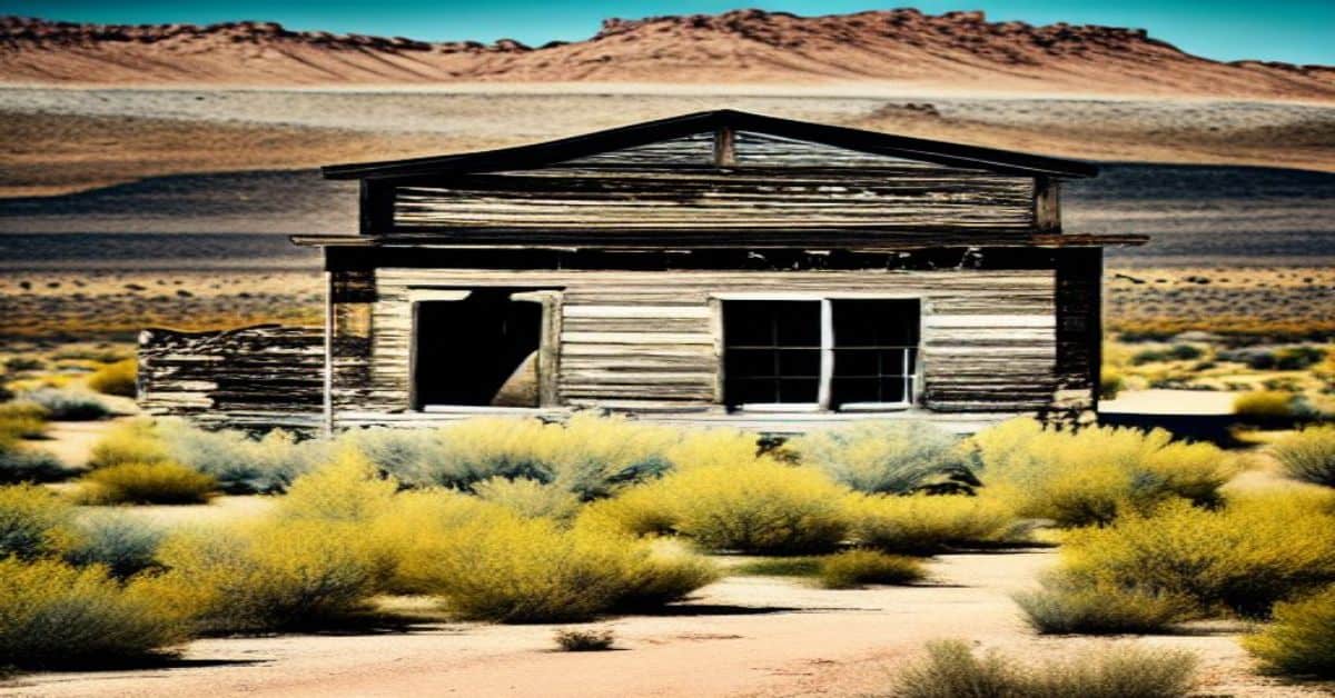
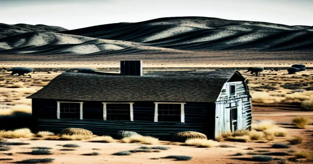
Aldridge, MT
County:
Park
Zip Code:
Latitude / Longitude:
45°05’14N 110°45’18W
Elevation:
6,427 ft (1,959 m)
Time Zone:
Mountain (MST) (UTC-7)
Established:
1901
Disestablished:
1910
Comments:
Aldridge is a ghost town in Park County, Montana. According to the book Ghost Towns of the Montana Prairie, the town was incorporated as Aldridge in 1906 but was earlier named Horr, and later Electric. Aldridge is a mining town that supplied coke and coal to the smelters for the Anaconda Copper Mining Company. Aldridge is located two miles north of the northern entrance to Yellowstone National Park.
Remains:
The Aldridge mines were safe compared to other mines in the area. In the mine’s operation history there was only one recorded accident on the site. According to the Anaconda Standard, on August 2, 1901, Thomas W. Thomas lost his life in the mine. Thomas was killed by an explosion. The cause of the explosion was never determined but could have been caused by explosive gas or an unexploded blast.
Current Status:
In 1906, with popular community support, Aldridge absorbed Electric and incorporated. Local newspapers predicted that Aldridge would become one of the most important coal and coke mining camps in the country. Although Aldridge had a bright future, the Montana Coal and Coke Company defaulted in payments of bonds in 1910. The default led to a suit between the company and the bondholders. The bondholders won the suit and the Montana Coal and Coke Company was sentenced to pay over 100,000 dollars. This debt led to the closure of all the mining operations in Aldridge. With the closure of the mines, Aldridge became a ghost town.
Remarks:
In 1901 the Montana Coal and Coke Company was operating at maximum capacity in Aldridge. They employed over 500 men and shipped out over 650 train cars of coke per day. All the coal was mined on the 3,000 acres of land surrounding Aldridge, but in August 1904 the miners went on strike. This strike lasted a year and crippled the local economy. The company recovered but never returned to its past glory. Prior to 1904, an electric plant was built in Horr to supply the Montana Coal and Coke Company’s mines and businesses with electricity. In 1904, Horr was renamed Electric because of the power plant built on the townsite. With no mines operating in Electric, its economy survived by transporting coke to the smelters from its railhead.
Alton, MT
County:
Zip Code:
Latitude / Longitude:
Elevation:
Time Zone:
Mountain (MST) (UTC-7)
Established:
Disestablished:
Comments:
Remains:
Current Status:
Remarks:
Argo, MT
County:
Zip Code:
Latitude / Longitude:
Elevation:
Time Zone:
Mountain (MST) (UTC-7)
Established:
Disestablished:
Comments:
Remains:
Current Status:
Remarks:
Bannack State Park, MT
County:
Zip Code:
Latitude / Longitude:
Elevation:
Time Zone:
Mountain (MST) (UTC-7)
Established:
Disestablished:
Comments:
Remains:
Current Status:
Remarks:
Barker, MT
County:
Judith Basin
Zip Code:
Latitude / Longitude:
Elevation:
Time Zone:
Mountain (MST) (UTC-7)
Established:
Disestablished:
Comments:
Remains:
Current Status:
Remarks:
Bean, MT
County:
Carbon
Zip Code:
Latitude / Longitude:
Elevation:
Time Zone:
Mountain (MST) (UTC-7)
Established:
Disestablished:
Comments:
Remains:
Current Status:
Remarks:
Bear Creek, MT
County:
Carbon
Zip Code:
59007
Latitude / Longitude:
45°9’35N 109°9’23W
Elevation:
4,557 ft (1,389 m)
Time Zone:
Mountain (MST) (UTC-7)
Established:
Disestablished:
Comments:
Bearcreek is an incorporated town in Carbon County, Montana, United States. It is part of the Billings, Montana Metropolitan Statistical Area. The population was 79 at the 2010 census. Bearcreek uses the Mayor/Council form of government.
Remains:
The town of Bearcreek was named Bear Creek, which runs through the middle of town. Bearcreek came into existence due to coal mines and grew rapidly following the building of a short line railroad connecting the Bearcreek mines to the Northern Pacific Railroad in 1906. Between 1906 and 1953, the mines at Bearcreek produced large volumes of coal, which was a higher grade than other regional sources, from the extensive underground coal mining deposits. The mines were located along the creek and also in the surrounding coulees. The development of the coal mines after 1906 drew miners to the area. They came from other parts of America, and from Serbia, Montenegro, Germany, Scotland, and Italy. The recent immigrants built separate ethnic-based communities in the steep coulees that run down into Bearcreek, with names like Washoe, New Caledonia, Chickentown, Scotch Coulee, International, and Stringtown. At one time in the 1920s and 1930s, the population of Bearcreek combined with the other surrounding small communities was close to 3,000 persons.
Current Status:
Today, the many surrounding communities that made up Bearceek are almost completely gone, with only a few houses marking Washoe, currently the largest of them. In the last decades, there is some growth of the tiny remaining community of Bearcreek thanks to its proximity to Red Lodge which has developed an economy to serve tourists who come to ski, or to use summer cabins, or to pass through to Yellowstone Park.
Remarks:
Bearcreek owes its existence to area coal mining that began in the 1890s to supply coal for the Northern Pacific Railway and the Anaconda Company. The Bearcreek Post Office was established on November 22, 1905, with Sarah Criger as the town’s first postmaster. The town was platted and incorporated after the arrival of the Montana, Wyoming & Southern Railroad in 1906.
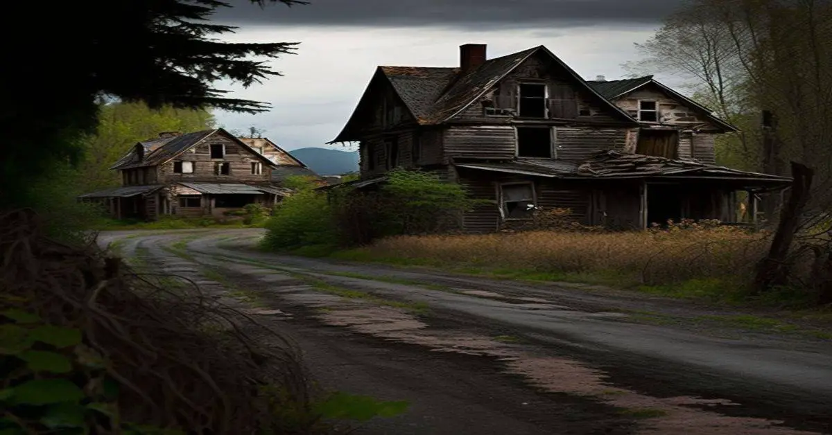
Bearmouth, MT
County:
Granite
Zip Code:
Latitude / Longitude:
46°42’37N 113°19’53W
Elevation:
3,802 ft (1,159 m)
Time Zone:
Mountain (MST) (UTC-7)
Established:
Disestablished:
Comments:
Bearmouth was a trading post for the placer mining camps of Beartown, Garnet, and Coloma, located in the hills north of Bearmouth. A pioneer family named Lannen operated the gold exchange and ferry boat across the Clark Fork River.
Remains:
Bearmouth was not a mining camp, but rather a town that depended on the survival of other towns that were mining camps, such as neighboring Garnet. During the late 19th century, enormously rich ores from Garnet came into Bearmouth to be shipped to smelters. When Garnet died, Bearmouth followed suit. The town, however, was also a main stop for stagecoaches on the old Mullan Road. As such, it had a beautiful two-storied, balconied inn for travelers to spend the night as well as a large livery stable, both of which still stand.
Current Status:
The Hazel Marsh Papers is a collection of records from the many Lannen family businesses in Bearmouth. The post office, saloon, and general store ledger books are in the collection as well as financial records and legal documents from Christopher Lannen. School district records and voter registrations from Bearmouth are also in the collection. The collection also contains photographs and memorabilia and is located at the Maureen and Mike Mansfield Library, K. Ross Toole Archives, University of Montana.
Remarks:
In September 1841, the intrepid Jesuit priest, Pierre Jean De Smet, traveled westward through this area on his way from St. Louis, to establish a mission for the Flathead Indians in the Bitterroot Valley. The nearest town is Drummond, about eight miles to the east. The nearest large city is Missoula, about 20 miles to the west. The next large city to the east is Butte, about 100 miles away.
Bighorn, MT
County:
Hardin
Zip Code:
Latitude / Longitude:
45° 25′ 48 N, 107° 29′ 24 W
Elevation:
Time Zone:
Mountain (MST) (UTC-7)
Established:
Disestablished:
Comments:
Big Horn County is a county in the U.S. state of Montana. As of the 2010 census, the population was 12,865. The county seat is Hardin. The county, like the river and mountain range, was named for the bighorn sheep in the Rocky Mountains. The county was founded in 1913. It is immediately to the north from the northern Wyoming state line.
Remains:
Big Horn County in Montana and Wyoming are two of twenty-two counties or parishes in the United States with the same name to border each other across state lines. The others are Sabine County, Texas and Sabine Parish, Louisiana, Union County, Arkansas, and Union Parish, Louisiana, Bristol County, Massachusetts, and Bristol County, Rhode Island, Kent County, Maryland and Kent County, Delaware, Escambia County, Alabama, and Escambia County, Florida, Pike County, Illinois, and Pike County, Missouri, Teton County, Idaho, and Teton County, Wyoming, Park County, Montana and Park County, Wyoming, San Juan County, New Mexico, and San Juan County, Utah, and Vermilion County, Illinois and Vermillion County, Indiana. respectively. (Note, despite the different spellings, the source of the name is the same for Vermilion County, Illinois, and Vermillion County, Indiana—the Vermillion River which flows through both counties.)
Current Status:
Remarks:
Coal mining and agriculture both play major roles in Big Horn County’s economy. Farms and ranches in the county produce mainly beef cattle, sugar beets, alfalfa, and small grains.
Beehive, MT
County:
Stillwater
Zip Code:
59001
Latitude / Longitude:
45°28’44N 109°43’14W
Elevation:
4,629 ft (1,411 m)
Time Zone:
Mountain (MST) (UTC-7)
Established:
Disestablished:
Comments:
Beehive is an unincorporated community located in Stillwater County, Montana, and shares a postal ZIP code with Absarokee (59001).
Remains:
Beehive was established as a town in a deep valley along the Stillwater River west of Absarokee. Beehive had a post office from 1910 to 1953.
Current Status:
The community still thrives as a getaway destination with many seasonal mountain homes. Beautiful scenery along with great fishing can be found in and around Beehive.
Remarks:
The elevation is 4,629 feet. Beehive appears on the Beehive U.S. Geological Survey Map.
Bowler, MT
County:
Carbon
Zip Code:
Latitude / Longitude:
45° 12′ 18 N, 108° 43′ 8.4 W
Elevation:
4,698 ft
Time Zone:
Mountain (MST) (UTC-7)
Established:
Disestablished:
Comments:
Bowler is an unincorporated community located in Carbon County, Montana
Remains:
Bowler was an isolated agricultural community established in the late 1890s, situated in a valley at the foot of the Pryor Mountains. A post office operated in Bowler from 1894-1936, there was also a bar and a cemetery situated just outside town.
Current Status:
A few buildings and foundations located away from Pryor Mountain Road are all that remains today.
Remarks:
Cable, MT
County:
Deer Lodge
Zip Code:
Latitude / Longitude:
45° 26′ 10 N, 104° 3′ 54 W
Elevation:
Time Zone:
Mountain (MST) (UTC-7)
Established:
Disestablished:
Comments:
Remains:
Current Status:
Remarks:
Capitol, MT
County:
Carter
Zip Code:
Latitude / Longitude:
Elevation:
Time Zone:
Mountain (MST) (UTC-7)
Established:
Disestablished:
Comments:
Capitol is a ghost town in Carter County, Montana, United States. Capitol was named after Capitol Rock, a prominent landmark in the nearby Long Pine Hills. Capitol is located on the Little Missouri River and close to the South Dakota border.
Remains:
Capitol had a post office from 1891–1982. Residents who have a Capitol address receive their mail from the neighboring post office of Camp Crook, South Dakota. A church named ‘Little Missouri Lutheran Church’ is located near Capitol. The congregation celebrated its 125th anniversary in 2014. The church was established 5 months before Montana became a state.
Current Status:
Capitol is a ghost town with two remaining buildings.
Remarks:
Capitol Cemetery is located northeast of town on Little Missouri Road. Little Missouri Lutheran Church Cemetery located behind the current Church location.
Carlyle, MT
County:
Wibaux
Zip Code:
Latitude / Longitude:
46° 39′ 18 N, 104° 4′ 34 W
Elevation:
Time Zone:
Mountain (MST) (UTC-7)
Established:
Disestablished:
Comments:
Carlyle is a ghost town in Wibaux County, Montana, United States, located approximately 1 to 1 1/2 miles west of the North Dakota border, sitting on a ranch, which incorporated the once agricultural town into grazing land.
Remains:
Current Status:
Some of the buildings once a part of the town are just foundations, however, a farmstead east of the town is still standing, with the schoolhouse, grain elevators, and a couple of the homes inside the town. Southeast of the town of Carlyle is the cemetery. Carlyle had a population of 221 in the 1940s, with access to the North Pacific Railroad branch out of Beach, North Dakota.
Remarks:
Carter, MT
County:
Chouteau
Zip Code:
59420
Latitude / Longitude:
47°46’53N 110°57’21W
Elevation:
3,123 ft (952 m)
Time Zone:
Mountain (MST) (UTC-7)
Established:
Disestablished:
Comments:
Carter is a census-designated place (CDP) in Chouteau County, Montana, United States.
Remains:
The Carter, Montana Hall of Fame honors celebrities who have stepped foot into the city. As of 2010, there were seven inductees, including Keanu Reeves, Arsenio Hall, Charlie Sheen, Eddie Vedder, Steve Smith, and Harry Truman. Professional wrestler CM Punk was inducted into the Hall of Fame on May 15, 2010.
Current Status:
The population was 58 at the 2010 census.
Remarks:
Castle Town, MT
County:
Meagher
Zip Code:
Latitude / Longitude:
46°26’29N 110°40’19W
Elevation:
5,978 ft (1,822m)
Time Zone:
Mountain (MST) (UTC-7)
Established:
Disestablished:
Comments:
Remains:
Current Status:
Remarks:
Chico, MT
County:
Park
Zip Code:
59027
Latitude / Longitude:
45°19’17N 110°42’16W
Elevation:
5,433 ft (1,656 m)
Time Zone:
Mountain (MST) (UTC-7)
Established:
Disestablished:
Comments:
Chico Sometimes called “Old Chico” to distinguish it from the nearby Chico Hot springs Resort. Chico is an unincorporated community in Park County, Montana, United States. The population of Chico was 15 as of 2010. Chico currently shares a postal ZIP code 59027 with a nearby Emigrant.
Remains:
Old Chico or Chico City was established as a town in 1874 but had grown into a permanently populated community much earlier, making it one of Montana’s oldest surviving settlements. It is situated in the mouth of Emigrant Gulch. The Chico post office was open from 1874 until 1919.
Current Status:
Many historic buildings still stand in Chico today, including the old schoolhouse and store, as well as boarding house apartments from the height of its mining days. There are efforts to preserve or restore some of these structures. The town can be reached both by car or by horseback from the Chico Hot springs resort and is surrounded by impressive views and scenery.
Remarks:
Gold was discovered in the Chico area in 1863. Mining in the Curry Mining District was begun in the spring of 1894. During this period, miners working in the area lived in a settlement called Yellowstone City. Due to harassment by Crow Indians, Yellowstone City was abandoned by 1865. After Yellowstone City’s demise, a new settlement was built at Chico. The Chico townsite was closer to Emigrant Gulch and the mining activity. Chico’s population in 1874 was 300. Eventually a school, general store and two boarding houses were built at the site. The town never had a saloon. As the threat from the Crow abated, houses were built further up Emigrant Gulch and closer to the mines. The St. Julian Mine was opened in 1887. Ore from the St. Julian assayed out at $360 in gold and $40 in silver per ton of ore. A ten stamp mill was built in the late 1890s and a 12 stamp mill in 1904. The 1904 mill also had a Blake Crusher and 6 Frue Venners.
Coburg, MT
County:
Blaine
Zip Code:
Latitude / Longitude:
Elevation:
Time Zone:
Mountain (MST) (UTC-7)
Established:
Disestablished:
Comments:
Remains:
Current Status:
Remarks:
Coloma, MT
County:
Zip Code:
Latitude / Longitude:
Elevation:
Time Zone: Mountain (MST) (UTC-7)
Established:
Disestablished:
Comments:
Remains:
Current Status:
Remarks:
Comanche, MT
County:
Yellowstone
Zip Code:
59002
Latitude / Longitude:
45°59’51N 108°46’24W
Elevation:
3,747 ft (1,142 m)
Time Zone:
Mountain (MST) (UTC-7)
Established:
Disestablished:
Comments:
Comanche is an unincorporated community in Yellowstone County, Montana. It lies on Montana Highway 3, 16 miles northwest of the city of Billings, and shares a postal ZIP code with Acton (59002).
Remains:
Comanche was established as a railroad station on the Great Northern Railroad northwest of Billings. It was named for the famous horse that was the only living thing found on the battlefield after the Battle of the Little Big Horn as was the town’s geographical region, Comanche Flat.
Current Status:
Comanche today has little left of its original structures. Some newer subdivisions, the original grain elevator, the depot, a hotel, the main street, and Comanche Cemetery west of town are all that remain. The post office was active in Comanche from 1909 to 1942 with Lola Dell Helm as postmaster.
Remarks:
The village declined with the advent of changing transportation technologies and demographics. A Methodist Church and parsonage once existed in Comanche before being moved to nearby Broadview.
Comertown, MT
County:
Sheridan
Zip Code:
Latitude / Longitude:
48°53’49N 104°14’56W
Elevation:
Time Zone:
Mountain (MST) (UTC-7)
Established:
1913
Disestablished:
Comments:
Hometown is an unincorporated community in northeastern Sheridan County, Montana, United States. Founded in 1913, it was established as a station stop on the Soo Line Railroad branch line to Whitetail.
Remains:
Although the land around Comertown attracted numerous homesteaders during the first years following the railroad’s completion, the region proved to be unsuited for intensive agricultural use, and by the 1920s Comertown was in decline. Though the railroad remains in operation, the community is now abandoned, and only a handful of buildings remain.
Current Status:
The post office at Comertown operated from November 14, 1914, to June 30, 1957. A school and a cemetery were also established at Comertown.
Remarks:
In 1993, the entire community was listed on the National Register of Historic Places as a historic district.
Comet, MT
County:
Jefferson
Zip Code:
Latitude / Longitude:
46°18’39N 112°10’12W
Elevation:
Time Zone:
Mountain (MST) (UTC-7)
Established:
1883
Disestablished:
1941
Comments:
Comet is a ghost town located about twenty miles (32 kilometers) south-southwest of Helena, Montana, United States. It is reached by following High Ore Road north from Interstate 15.
Remains:
The town is named for the Comet Mine, which was developed in 1883 by the Helena and Livingston Smelting and Reduction Company, based on a discovery made in 1874. Ore was transported to another mine in Wickes for processing. This operation shut down in 1897. Operations were revived in 1900 under the Montana Consolidated Copper Company; in 1927 the Basin Montana Tunnel Company took over the property and built a processing plant on the site for both this mine and the nearby Gray Eagle mine. The company was the largest producer of base metals in the state, outside of Butte, Montana, due to production at this mine. They employed 100 men. The operations of BMTC continued until 1941 when the mine was exhausted and operations were permanently halted.
Current Status:
The remains of the town cover about thirty-five acres and consist of an ore hopper, a large ore processing building, several other company buildings, and numerous houses and other private structures. High Ore Creek runs through the center of the property and separates the mine buildings from the town proper. The town is abandoned except for a single active residence; although it sits on private grazing land, it is open to public access.
Remarks:
In 1997 a reclamation project was begun to alleviate pollution caused by toxic metal leachage from the tailings. This project was completed in June of the following year and consisted of moving the tailings into a single pile south of the processing building which was then fenced off and planted. The project, which was overseen by the Mine Waste Cleanup Bureau of the Montana Department of Environmental Quality, was judged to be successful. In 2006 the department received a National Award from the U.S. Office of Surface Mining in recognition of the work done for this project.
Coolidge, MT
County:
Zip Code:
Latitude / Longitude:
Elevation:
Time Zone: Mountain (MST) (UTC-7)
Established:
Disestablished:
Comments:
Remains:
Current Status:
Remarks:
Copperopolis, MT
County:
Meagher
Zip Code:
Latitude / Longitude:
46°36’53N 110°40’00W
Elevation:
5,652 ft (1,723 m)
Time Zone:
Mountain (MST) (UTC-7)
Established:
Disestablished:
Comments:
Remains:
Current Status:
Remarks:
Corwin, MT
County:
Zip Code:
Latitude / Longitude:
Elevation:
Time Zone:
Mountain (MST) (UTC-7)
Established:
Disestablished:
Comments:
Remains:
Current Status:
Remarks:
Coulson, MT
County:
Zip Code:
Latitude / Longitude:
45° 47′ 20 N, 108° 28′ 41 W
Elevation:
Time Zone:
Mountain (MST) (UTC-7)
Established:
Disestablished:
Comments:
Coulson, Montana was a town located on the north bank of the Yellowstone River approximately one mile east of the present day downtown Billings, Montana.
Remains:
Current Status:
Remarks:
Dean, MT
County:
Stillwater
Zip Code:
59061
Latitude / Longitude:
45°24’16N 109°41’25W
Elevation:
5,244 ft (1,598 m)
Time Zone:
Mountain (MST) (UTC-7)
Established:
1913
Disestablished:
1957
Comments:
Dean is an unincorporated community located in Stillwater County, Montana.
Remains:
Located on the north side of the Beartooth Mountains, Dean has its roots mainly in agriculture and a few nearby mines. Dean had an active post office in 1902-1914 and 1915-1951.
Current Status:
Today, Dean survives as a small community with a number of permanent and seasonal homes.
Remarks:
Dooley, MT
County:
Sheridan
Zip Code:
Latitude / Longitude:
48°52’52N 104°23’22W 104°23’22W
Elevation:
2,461 ft (750 m)
Time Zone:
Mountain (MST) (UTC-7)
Established:
Disestablished:
Comments:
Dooley is a ghost town in northeastern Sheridan County, Montana, United States. The town was established as a station stop and one of the first four depots along the Soo Line Railroad branch line to Whitetail, Montana.
Remains:
The town began in 1913 when the railroad was coming through and landed on the corner of W.D Dooley’s property. Around 40 buildings went up at once, to become the business area. It was one of the only towns not to move since the beginning of the railroad. George Epler was the town cashier and the organizer of the Citizen State Bank. Guy Clerke and the Epler Brothers had two general stores in town. George Wright owned the hardware store, where they would hold different gatherings upstairs until the theater was built. The Confectionery and the post office were owned by Peter Hegseth. The post office at Dooley operated from 1914 to 1957. He had to rebuild them after they caught in a fire. There were two saloons in town one owned by Hans Nelson and the other Jim Kings.
Current Status:
Over the years people moved to the surrounding areas due to the fires and infestations. The town’s population slowly dwindled and the buildings were sold or torn down. The elevators were sold to Jim Syme.
Remarks:
Dooley suffered many different kinds of disasters. In May 1916, the west side of Main Street caught on fire, wrecking many of the businesses. Four years later the east side suffered a fire destroying many of the local businesses. Also a year before, in 1919 a smaller fire took place and wrecked a garage and two smaller businesses. In 1934 a tornado came through town, wiping out the Stadig Livery Barn. The town also suffered infestations of armyworms, grasshoppers, and Mormon crickets, which harmed local agriculture. Some of the winters that the town faced were very severe and kept the train from passing through. The trains feared that they would freeze up or run out of fuel.
Electric, MT
County:
Park
Zip Code:
Latitude / Longitude:
45°05’14N 110°45’18W
Elevation:
6,427 ft (1,959 m)
Time Zone:
Mountain (MST) (UTC-7)
Established:
1901
Disestablished:
1910
Comments:
Aldridge is a ghost town in Park County, Montana. According to the book Ghost Towns of the Montana Prairie, the town was incorporated as Aldridge in 1906 but was earlier named Horr, and later Electric. Aldridge is a mining town that supplied coke and coal to the smelters for the Anaconda Copper Mining Company. Aldridge is located two miles north of the northern entrance to Yellowstone National Park.
Remains:
Prior to 1904, an electric plant was built in Horr to supply the Montana Coal and Coke Company’s mines and businesses with electricity. In 1904, Horr was renamed Electric because of the power plant built on the townsite. With no mines operating in Electric, its economy survived by transporting coke to the smelters from its railhead.
Current Status:
Today there is no active mining, but there is still an abundance of coal deposits in the area. Some of the buildings of Aldridge have been torn down or relocated, but the other buildings are in ruins.
Remarks:
In 1906, with popular community support, Aldridge absorbed Electric and incorporated. Local newspapers predicted that Aldridge would become one of the most important coal and coke mining camps in the country. Although Aldridge had a bright future, the Montana Coal and Coke Company defaulted in payments of bonds in 1910. The default led to a suit between the company and the bondholders. The bondholders won the suit and the Montana Coal and Coke Company was sentenced to pay over 100,000 dollars. This debt led to the closure of all the mining operations in Aldridge. With the closure of the mines, Aldridge became a ghost town.
Elkhorn, MT
County:
Jefferson
Zip Code:
Latitude / Longitude:
46°16’29N 111°56’45W
Elevation:
6,443 ft (1,964 m)
Time Zone:
Mountain (MST) (UTC-7)
Established:
1872
Disestablished:
1970s
Comments:
Elkhorn is a small ghost town and a CDP in Jefferson County, Montana, United States, in the Elkhorn Mountains of the southwestern part of the state. Elkhorn is also a Montana State Park.
Remains:
Lodes of silver, described by geologists as supergene enrichments, were initially discovered in the Elkhorn mountains by Peter Wys, a Swiss immigrant. Six years later, Anton Holter, a pioneer capitalist from Helena, Montana, began developing the mine. Over $14 million in silver was carried from the mine. In 1890, the Sherman Silver Purchase Act passed, creating a high demand for Elkhorn’s silver.
Current Status:
It can only be reached through its neighboring town, Boulder, Montana by taking the I-15 at Boulder exit, continuing 7 miles (11 km) south on Montana 69, then 11 miles (18 km) north on county graveled road. While very few standing buildings remain of the original Elkhorn, a number of cabins have been reoccupied and refurbished. In 2010, there were 10 inhabitants.
Remarks:
During this peak period, Elkhorn had 2,500 inhabitants, a school, a hotel, a church, stores, saloons, and brothels. Unlike most mining towns, Elkhorn was populated mostly by married European immigrants. In 1893 the Fraternity Hall was constructed for social gatherings and still remains as one of the most well-preserved buildings in modern Elkhorn. In the years following, the silver boom and Elkhorn’s prosperity began to lessen as the desire for silver decreased. A diphtheria epidemic also struck Elkhorn in the winter of 1888–1889, resulting in many deaths, particularly of children. Soon after, railroad service to Elkhorn was halted and only a fraction of the original inhabitants remained.
Ewing, MT
County:
Carbon
Zip Code:
Latitude / Longitude:
Elevation:
Time Zone:
Mountain (MST) (UTC-7)
Established:
Disestablished:
Comments:
Remains:
Current Status:
Remarks:
Exeter, MT
County:
Phillips
Zip Code:
Latitude / Longitude:
Elevation:
Time Zone:
Mountain (MST) (UTC-7)
Established:
Disestablished:
Comments:
Remains:
Current Status:
Remarks:
Finch, MT
County:
Rosebud
Zip Code:
Latitude / Longitude:
Elevation:
Time Zone:
Mountain (MST) (UTC-7)
Established:
Disestablished:
Comments:
Remains:
Current Status:
Remarks:
Fox, MT
County: Carbon
Zip Code: 59070
Latitude / Longitude: 45°16’36N 109°13’01W
Elevation: 5,031 ft (1,533 m)
Time Zone: Mountain (MST) (UTC-7)
Established:
Disestablished:
Comments: Fox is an unincorporated community in Carbon County, Montana, United States. It was named for Dr. J.M. Fox, the first manager of the Rocky Fork Coal Company and the Rocky Fork & Cooke City Railroad.
Remains: At one time, Fox had two elevators and was the largest grain shipping point in Carbon County. Finnish immigrant miners settled here, and as late as 1920 their children still spoke Finnish at home and on the playground, and English only in the classroom.
Current Status: Fox was an important stop on the Northern Pacific Railway to Red Lodge, and many of the buildings still stand, most notably the old Fox Elevator. Although it is unincorporated, Fox has a post office with a ZIP code of 59070. Fox lies on U.S. Route 212 southwest of Roberts and northeast of Red Lodge.
Remarks: