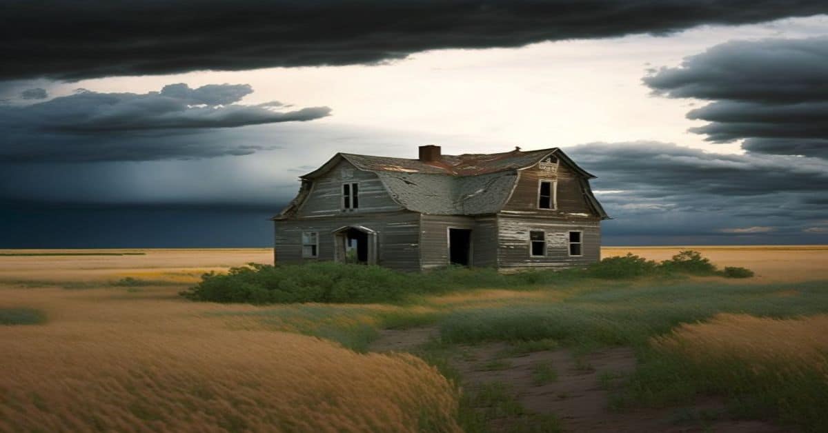
Acala, TX
County:
Hudspeth
Zip Code:
79839
Latitude / Longitude:
31°20’02″N 105°54’52″W
Elevation:
3,553 ft (1,083 m)
Time Zone:
Central (CST) (UTC-6)
Established:
Disestablished:
Comments:
Acala is a ghost town in Hudspeth County, Acala, thirty-four miles northwest of Sierra Blanca and fifty-four miles southeast of El Paso, with a current population of about 25. Acala is located on Highway 20. Acala was named for Acala cotton. a type of cotton produced in Mexico.
Remains:
The area was settled in the early 20th century, when a post office was established before 1925. In 1929, the population had doubled to a hundred from its fifty residents just a couple of years before. It peaked again in the late ’50s, at one hundred people, but began to fall, once again.
Current Status:
Only twenty-five people called Acala home by the 1970s. Since then it has remained at that size.
Remarks:
Acme, TX
County:
Hardeman
Zip Code:
Latitude / Longitude:
34° 19′ 0″ N, 99° 49′ 26″ W
Elevation:
Time Zone:
Centra(CST) (UTC-6)
Established:
Disestablished:
Comments:
Acme is a ghost town in Hardeman County, Texas, United States.
Remains:
Current Status:
Remarks:
Adkins, TX
County:
Bexar
Zip Code:
Latitude / Longitude:
29° 23′ 35″ N, 98° 14′ 14″ W
Elevation:
Time Zone:
Central (CST) (UTC-6)
Established:
Disestablished:
Comments:
Adkins is an Unincorporated community in eastern Bexar County, Texas, United States. It lies on FM 1518, about one mile north of the Texas Pride Restaurant.
Remains:
The town of Adkins was named for William Adkins Jones who donated land for a flag station on the Galveston, Harrisburg and San Antonio Railway in the late 1800s. He owned a general store and was the first Adkins postmaster when a post office was established there in 1896. In the early 1900s the town had a population of about a hundred, two churches, and a school.
Current Status:
After the rail line was abandoned and the major highways by-passed the town, the population steadily declined. In 1915 the post office was moved to nearby Sayers, however the post office and postal area are still called Adkins, even though almost nothing of the original town now remains. Adkins is home to Texas Pride BBQ, which was featured on the Food Network show Diners, Drive-Ins, and Dives. Adkins is also home to Cactus Land Brewing Company, which is a small artisan craft brewery dedicated to brewing with local ingredients and high quality malt.
Remarks:
Adobes, TX
County:
Presidio
Zip Code:
Latitude / Longitude:
29° 45′ 34″ N, 104° 33′ 13″ W
Elevation:
Time Zone:
Central (CST) (UTC-6)
Established:
Disestablished:
Comments:
Adobes, Texas was a small farming community and now-ghost town, located on the Rio Grande river and FM 170. It was founded in the 1870s. Cotton began to be grown in the area in 1914, and by 1930 the community had 750 acres of irrigated land.
Remains:
Current Status:
Remarks:
Adobe Walls, TX
County:
Hutchinson
Zip Code:
Latitude / Longitude:
Elevation:
Time Zone:
Central (CST) (UTC-6)
Established:
Disestablished:
Comments:
Adobe Walls is a ghost town in Hutchinson County, 17 miles (27 km) northeast of Stinnett, in the U.S. state of Texas. It was established in 1843 as a trading post for buffalo hunters and local Indian trade in the vicinity of the Canadian River. It later became a ranching community. Historically, Adobe Walls is the site of two decisive battles between Native Americans and Anglo forces. In November 1864 First Battle of Adobe Walls, Native Americans successfully repelled attacking troops led by Kit Carson. Ten years later, on June 27, 1874, known as the Second Battle of Adobe Walls, civilians at the Adobe Walls trading post successfully fought off an attack by a war party of mainly Comanche and Cheyenne warriors led by the Comanche chief, Quanah Parker. The second battle led to a military campaign which resulted in the relocation of Native Americans to Indian Territory in Oklahoma. On May 22, 1978, the Adobe Walls site was added to the National Register of Historic Places in Texas, and in 1979 recognized as a Texas state archeological landmark.
Remains:
In 1843, the trading firm of Bent, St. Vrain & Company established a log structure trading site on what is now known as Bent Creek in Hutchinson County. In 1845, they replaced the log structure with an adobe brick 80 square feet (7.4 m2) single-entrance fort, with walls that rose 9 metres (30 ft). The fort was closed in 1848, due to Indian depredations. In 1849, William Bent found part of his livestock slaughtered by local Indians. He blew up the remains of the fort and departed the panhandle of Texas. By the time of the renowned battles, the adobe structure was permanently abandoned, leaving only the crumbling adobe walls. In 1874, a new complex was erected north of the ruins by traders from Kansas.
Current Status:
Dixon was appointed the first postmaster when Adobe Walls received its post office on August 3, 1887. Dixon ran the post office out of his home, where he and business partner S.G. Carter also had a store. Dixon served as postmaster until 1901, at which time Otto Anderson was appointed postmaster. The post office was in operation until 1921, when it was closed and mail service moved to Plemons. Adobe Walls was a polling site, and voting there in the 19th Century was a multi-day community event that included barbecue and accompaniments. Today, Adobe Walls is a ghost town. In 1923 the Panhandle-Plains Historical Society became owners of the remains of the 1874 trading post, and conducted archeological excavations in the 1970s
Remarks:
Dixon described the 1874 establishment, “All the buildings at Adobe Walls faced to the east, the main ones standing in a row. On the south was the store of Rath & Wright, with a great pile of buffalo hides at the rear. Then came Hanrahan’s saloon, and fifty yards or so north of the latter was the store of Leonard & Myers, the building forming the northeast corner of the big picket stockade. In the southwest corner of the stockade was a mess house and the store as well. The blacksmith’s shop was located just north of Hanrahan’s saloon. The adobe walls of the main buildings were about two feet thick.”
Agle Creek, TX
County:
Zip Code:
Latitude / Longitude:
Elevation:
Time Zone:
Central (CST) (UTC-6)
Established:
Disestablished:
Comments:
Remains:
Current Status:
Remarks:
Albert, TX
County:
Gillespie
Zip Code:
Latitude / Longitude:
30°11’38″N 98°36’06″W
Elevation:
1,476 ft (450 m)
Time Zone:
Central (CST) (UTC-6)
Established:
Disestablished:
Comments:
Albert, originally Martinsburg, is a ghost town 16 miles (25.7 km) southeast of Fredericksburg and 1 mile (1.6 km) west of the Blanco County line in southeastern Gillespie County, Texas, United States. The town was a stop on the Fredericksburg-Blanco stage route and in 1967 became a stop on the President’s Ranch Trail. In late October 2007, the town was put up for sale on the auction website eBay.
Remains:
On December 15, 1847, a petition was submitted to create Gillespie County. In 1848, the legislature formed Gillespie County from Bexar and Travis counties. For more details on this topic, see List of Petitioners to Create Gillespie County, Texas. While the signers were overwhelmingly German immigrants, names also on the petition were Castillo, Pena, Munos, and a handful of non-German Anglo names. The first white settlers were George Cauley, Ben White, Sr., and a man named Jacobs. Around 1877, blacksmith Fritz Wilke, George Maenius, and John Petri moved from Fredericksburg seeking pasture for their cattle. Wilke bought land from a man named Elmeier, who was robbed and murdered years later.
Current Status:
In 2004, Bobby Cave, at the time an insurance broker, bought Albert—more specifically, property on Ranch Road 1623 between Stonewall and Blanco— for $216,000. Cave then built a tavern (in a style area locals call an icehouse) on the site of the town’s former general store; after investing nearly half a million dollars, in 2007 he put it up for sale on eBay with a reserve price of $2.5 million. In 2009 the town was carved up and again for sale, this time with an asking price of $883,000. 12.09 acres (48,900 m2) of the town was purchased by the Easley family (Point Evans, LLC) from Austin, Texas, and Brandon Easley, was nominated by the family to be the town manager. He has made several improvements to the ice house and surrounding property, and currently the dance hall is under renovation.
Remarks:
Albert had 50 residents in 1925, only 4 in 1964, and 25 in 1972. By 1985 the store had been torn down, the school converted into a community club, and the dance hall a storage locker, though Albert still had 25 residents and two businesses. The population would stay at 25 through 2000, but by 2007, the town had been all but abandoned.
Albuquerque, TX
County:
Gonzales
Zip Code:
Latitude / Longitude:
29° 20′ 54″ N, 97° 50′ 34″ W
Elevation:
Time Zone:
Central (CST) (UTC-6)
Established:
Disestablished:
Comments:
Albuquerque, Texas was a settlement established in 1857 by Samuel McCracken and Henry Hastings. Its population grew, and following the American Civil War, the town boasted a mercantile store, saloon, blacksmith shop, cotton gin, and an elementary school. Its U.S. post office opened in 1870. Albuquerque, Texas is today a ghost town.
Remains:
Henry Hastings and Samuel McCracken, two brothers-in-law from Mississippi, were the town’s first residents, settling the area “located on the Clear Fork of Sandies Creek” in 1857. The town was originally thought to be in Wilson County, Texas, but was found to actually be in Gonzales County by a 1914 re-survey of county lines. Official recognition of Albuquerque occurred in 1870 with the opening of the post office. The McCracken family established a boarding house and blacksmith shop, and the town also had a store and saloon. There was an elementary school which operated during the 1870s and into the 1880s.
Current Status:
Albuquerque’s decline was attributed to the growth of nearby Union, Texas (now Union Valley), which was two miles south of Albuquerque, as well as the lack of railroad access. The Albuquerque Post Office closed for good in 1883, just thirteen years after opening. The town itself was completely abandoned by 1912 and is today a Texas ghost town.
Remarks:
Helm and Hardin had been adversaries in the ongoing Sutton–Taylor feud for several years at this point. While being distracted by Hardin, Jim Taylor crept up on Helm from behind and attempted to shoot him, but his revolver misfired. As the startled Helm turned, Taylor managed to get off a shot, striking Helm in the chest. Helm rushed Taylor, but Hardin shattered Helm’s arm with a shotgun blast. Helm then fled into the blacksmith shop. While Hardin held the townspeople at gunpoint, Taylor chased down Helm and unloaded the remaining five bullets into his head. As Hardin and Taylor mounted their horses and prepared to ride away, it is reported that witnesses heard them boast that they had accomplished what they had set out to do.
Aldridge, TX
County:
Jasper
Zip Code:
Latitude / Longitude:
Elevation:
Time Zone:
Central (CST) (UTC-6)
Established:
Disestablished:
Comments:
Aldridge, Texas is a ghost town in Jasper County. Formerly located on the Burr’s Ferry, Browndell, and Chester Railroad, the town’s economy was based on the lumber industry. However, in the 1910s, the city’s sawmill burned down multiple times, and in 1927 the railroad line running through the city was abandoned due to exhaustion of the local wood resources.
Remains:
Current Status:
Remarks:
Alexander, TX
County:
Erath
Zip Code:
Latitude / Longitude:
Elevation:
Time Zone:
Central (CST) (UTC-6)
Established:
Disestablished:
Comments:
Remains:
Current Status:
Remarks:
Allamore, TX
County:
Hudspeth
Zip Code:
Latitude / Longitude:
31°04’41″N 105°00’13″W
Elevation:
Time Zone:
Central (CST) (UTC-6)
Established:
Disestablished:
Comments:
Allamoore (sometimes spelled Allamore) is a small, unincorporated community in Hudspeth County, Texas, United States. It is located just north of Interstate 10, approximately 22 miles (35 km) southeast of Sierra Blanca and 11 miles (18 km) west of Van Horn. First settled in the 1880s, a post office was established in the area under the name Acme in 1884. It was closed two years later. A new post office opened in 1888 under the name Allamoore after the first postmistress, Alla R. Moore. It closed in 1895 only to open two years later under the same name.
Remains:
Throughout its history, Allamoore has remained a sparsely populated ranching community. The population stood at 10 in 1914 and rose to 25 by the mid-1920s. Just prior to the Great Depression, that figure grew to 75. In the mid-1930s, the population was estimated at around 25. Seventy pupils from the surrounding ranches attended Allamoore School. Allamoore experienced another increase in the mid-1940s, which lasted for around 20 years before the community went into permanent decline.
Current Status:
As of 2000, approximately 25 people reside in the Allamoore area. It is also one of the few cities in Texas that is in the Mountain Time Zone along with El Paso.
Remarks:
By 1988-89 school year, the 2,100-square-mile (5,400 km2) Allamoore Common School District (renamed the Allamoore Independent School District in 1993) had a total enrollment of three students – the smallest enrollment in Texas. On July 1, 1995, Allamoore ISD consolidated with the Culberson County Independent School District based in nearby Van Horn to form the Culberson County-Allamoore Independent School District.
Alum, TX
County:
Wilson
Zip Code:
Latitude / Longitude:
29° 17′ 43″ N, 97° 57′ 53″ W
Elevation:
Time Zone:
Central (CST) (UTC-6)
Established:
Disestablished:
Comments:
Alum is an unincorporated community in Wilson County, in the U.S. state of Texas.
Remains:
The first settlement was made at Alum before 1900. The community took its name from nearby Alum Creek.
Current Status:
Remarks:
Ammans Crossing, TX
County:
Kendall
Zip Code:
Latitude / Longitude:
29° 53′ 42″ N, 98° 40′ 16″ W
Elevation:
Time Zone:
Central (CST) (UTC-6)
Established:
Disestablished:
Comments:
Ammans Crossing is a ghost town in Kendall County, Texas, United States. It was located on the Upper Guadalupe River.
Remains:
Current Status:
Remarks:
Anarene, TX
County:
Archer
Zip Code:
Latitude / Longitude:
33° 29′ 6″ N, 98° 39′ 57″ W
Elevation:
Time Zone:
Central (CST) (UTC-6)
Established:
Disestablished:
Comments:
Anarene is a ghost town in Archer County, Texas, United States. Its name was used for the town portrayed in the film adaptation of Larry McMurtry’s novel, The Last Picture Show.
Remains:
Anarene was founded on the Wichita Falls and Southern Railroad in 1908, the same year the Belknap Coal Company opened a coal mine in nearby Newcastle. It was named for Anna Laurene Graham, the daughter of pioneer settler J. M. Keen. Keen began ranching in the area after serving in the Confederate Army in the American Civil War.
Current Status:
The town portrayed in the 1971 film adaptation of The Last Picture Show is called “Anarene”, although it is called “Thalia” in Larry McMurtry’s novel. The film was actually made some 8 miles to the north of Anarene, in McMurtry’s hometown of Archer City, which is widely believed to have been the model for McMurtry’s “Thalia”. Director Peter Bogdanovich intended the film as an homage to Howard Hawks’ Red River, set in Abilene, Kansas, and chose the name Anarene to evoke a correspondence. Anarene also appears in Bogdanovich’s 1990 adaptation of McMurtry’s sequel, Texasville.
Remarks:
Anarene’s primary industry was the transportation of coal from the Newcastle mine. In 1929 Anarene had a population of 100, a store, a schoolhouse, a post office, a blacksmith shop, a filling station, and a two-story hotel. An oil field was discovered nearby in 1921. By 1933 the population had declined to 20. In 1942, coal production ended at the Newcastle mine. The Anarene railroad station closed in 1951, and the railway itself was abandoned in 1954. The same year marked the end of production at the Anarene oil field. The post office, established in 1909, was discontinued in 1955.
Aransas City, TX
County:
Aransas
Zip Code:
Latitude / Longitude:
Elevation:
Time Zone:
Central (CST) (UTC-6)
Established:
Disestablished:
Comments:
Aransas City is a ghost town on the tip of the Live Oak Peninsula in Aransas County, Texas near present-day Fulton. It served as a port on Aransas Bay at its confluence with Copano Bay during the 1830s and 1840s, but declined following its loss of a Republic of Texas customhouse to the rival port of Lamar.
Remains:
Prior to the Texas Revolution, empresario James Power constructed his house on the northern tip of Live Oak Peninsula at the site of the former Spanish fort of Aránzazu, which guarded Copano Bay to the west. Power later founded the town in 1837 in what was then Refugio County and partnered with former Texas Governor Henry Smith to organize and advertise the town to potential settlers. Afterwards, several stores were established and the population reached 500. The town was incorporated in 1839, and included a customhouse for the Republic of Texas, and served as the county seat of Refugio County until 1840. The town was attacked by the Karankawa and Comanche Indians several times and was raided by the Mexican irregulars in 1838, 1839 and 1841.
Current Status:
After the founding of Corpus Christi by former Aransas City-resident Henry Kinney, the port was no longer the westernmost in Texas. It soon lost its customhouse to the rival port of Lamar in a controversial decision that contributed to the town’s demise: Lamar had been founded in 1839, on the other side of the present day Copano Bay Causeway (on Lamar peninsula) by settler James Byrne, who had been affiliated with Power. The town was named after the newly elected President Mirabeau B. Lamar, whom Byrne lobbied to, to relocate the Aransas City customhouse. Lamar complied with the request, ignoring an Aransas City petition that opposed the move, and soon Aransas City was stripped of its designation as the county seat. The events mirrored the political feud between Lamar, who was supported by Byrne, and former President Sam Houston, whom Power backed. Power moved on to Copano, and by 1847, Aransas City was largely abandoned and no longer had a functioning government.
Remarks:
Arden, TX
County:
Irion
Zip Code:
Latitude / Longitude:
31° 26′ 38″ N, 100° 46′ 1″ W
Elevation:
Time Zone:
Central (CST) (UTC-6)
Established:
Disestablished:
Comments:
Arden is a town in Irion County, Texas. Its population as of the 2000 United States Census was only one inhabitant. It was named for the Arden family, who claimed the area in 1885. With a post office established in 1890, and a school in 1892, the town grew to a population of 130 by 1947. However, drought and low cotton prices eventually suffocated the city, and most businesses were abandoned by 1966.
Remains:
Current Status:
Remarks:
Arispe, TX
County:
Hudspeth
Zip Code:
Latitude / Longitude:
31° 9′ 4″ N, 105° 16′ 30″ W
Elevation:
Time Zone:
Central (CST) (UTC-6)
Established:
Disestablished:
Comments:
Arispe (also known as La Valley is a ghost town in Hudspeth County, Texas. Founded in 1885, it was built around a railroad station house. At its peak in the early 20th century, the community had fifty-seven residents.
Remains:
Current Status:
Now mostly deserted except for a railroad switch, the former town is crossed by Interstate 10 and U.S. Highway 80.
Remarks:
Auburn, TX
County:
Ellis
Zip Code:
Latitude / Longitude:
32° 17′ 51″ N, 97° 4′ 38″ W
Elevation:
Time Zone:
Central (CST) (UTC-6)
Established:
Disestablished:
Comments:
Auburn is an unincorporated community in Ellis County, in the U.S. state of Texas.
Remains:
Auburn was originally called Autumn, having been first settled in the autumn season in the early 1850s. A post office was established under the name Auburn in 1877, and remained in operation until 1906.
Current Status:
Remarks:
Audra, TX
County:
Taylor
Zip Code:
Latitude / Longitude:
Elevation:
Time Zone:
Central (CST) (UTC-6)
Established:
Disestablished:
Comments:
Audra is a ghost town in Taylor County, Texas. Established around the beginning of the 20th century, the town grew around a general store built by C. Meno Hunt, Fred Robinson, and Frank Sheppard. The town was named after Sheppard’s daughter. In 1905, the population grew to a peak of around 75. However, in response to the construction of a railroad through the area, the town was abandoned and its residents founded the town of Bradshaw to the east.
Remains:
Current Status:
Remarks:
Audubon, TX
County:
Wise
Zip Code:
Latitude / Longitude:
Elevation:
Time Zone:
Central (CST) (UTC-6)
Established:
Disestablished:
Comments:
Audubon is a ghost town in Wise County, Texas. It was named for the naturalist John Audubon. With its first settler, D.D. Shirey, plotting the town in 1865. After becoming an important center of commerce in the area, with a Masonic lodge from 1879 to 1886, it was bypassed by the Fort Worth & Denver Railroad in 1883.
Remains:
Current Status:
By 1904, the town ceased to have a post office. A Texas state historical marker was erected at the former site of the town in 1970.
Remarks:
Ayres, TX
County:
Deaf Smith
Zip Code:
Latitude / Longitude:
Elevation:
Time Zone:
Central (CST) (UTC-6)
Established:
Disestablished:
Comments:
Remains:
Current Status:
Remarks:
Bankersmith, TX
County:
Kendall
Zip Code:
Latitude / Longitude:
30°08’23″N 98°49’09″W
Elevation:
Time Zone:
Central (CST) (UTC-6)
Established:
Disestablished:
Comments:
Bankersmith (also sometimes written as Banker Smith) is a ghost town in Kendall County, Texas, USA. The town was founded in 1913. It lies approximately halfway between Fredericksburg and Comfort, near the border of Gillespie County.
Remains:
Bankersmith originated in 1913 as a train station along the San Antonio, Fredericksburg and Northern Railway which served nearby Grapetown, Texas, running between Fredericksburg and Comfort. The town and rail station drew its name of “Bankersmith” from Temple Doswell Smith, an important Fredericksburg bank president who financed the railroad. In the early 1940s, the railroad abandoned the line running through Bankersmith.
Current Status:
In 2012, restaurateur Doug Guller purchased parts of the town on Craigslist, and renamed the town to “Bikinis, Texas” after Bikinis Sports Bar & Grill, his restaurant chain. The purchase price is not known, also some have questioned Guller’s ability to rename a town that no longer officially exists. Guller declared his intentions to turn the town into a tourist destination by creating a hall of fame for the bikini swimsuit, presenting its history beginning with its invention in 1946. Guller has said he had no plans to open a Bikinis Sports Bar & Grill restaurant at the location, but might start a bar inside an abandoned bus there. The bus resides at 30°8’24″N and 98°49’8″W. In 2015, Guller reverted to the name Bankersmith, wanting to mend fences with Fredericksburg.
Remarks:
The Old Tunnel of the San Antonio, Fredericksburg and Northern Railway As the town was located in the Texas Hill Country, it is near one of the few railroad tunnels in the state (the only railroad tunnel in Texas when it was constructed). The tunnel is 962 feet in length, took 6 months to dig, and cost $134,000 at the time. The tunnel is now part of Old Tunnel State Park and the home to thousands of bats. The Old Tunnel State Park provides an extensive amount of parking area for would be visitors, it is at the intersection of Old San Antonio Road and Alamo Road. Meanwhile, the southern end of the tunnel resides at 30°6’2″N and 98°49’15″W.
Bartonsite, TX
County:
Hale
Zip Code:
Latitude / Longitude:
Elevation:
Time Zone:
Central (CST) (UTC-6)
Established:
Disestablished:
Comments:
Remains:
Current Status:
Remarks:
Becton, TX
County:
Lubbock
Zip Code:
Latitude / Longitude:
33°47’01″N 101°38’52″W
Elevation:
3,255 ft (992 m)
Time Zone:
Central (CST) (UTC-6)
Established:
1910
Disestablished:
Comments:
Becton is an unincorporated community in northeast Lubbock County, about 18 mi (29 km) northeast of Lubbock, Texas. This small rural community lies on the high plains of the Llano Estacado in West Texas. Becton began as a ranching community and was originally named Bledsoe for W. E. Bledsoe of the Three Circle Ranch. Later, while applying for a post office in 1917, it was discovered that another Texas town was already named Bledsoe, so the name was changed to Becton, after Abner M. Becton, an early settler who donated land for a new school building.
Remains:
With regard to transportation, Becton is located around 1 mi (1.6 km) to the east of Farm to Market Road 400. The Fort Worth and Denver South Plains Railway, which extended from Estelline to Lubbock, used to pass through town but the BNSF Railway, which last owned and operated the railway, abandoned and removed the tracks in 1989. In the early days, mail reached Becton by way of Lorenzo Star Route until the Fort Worth and Denver South Plains Railway began operation in 1928. The post office was shut down in the 1940s.
Current Status:
Today, Becton is primarily a farming community and is surrounded by numerous sections of plowed land. The primary crop is cotton but lesser amounts of grain sorghum and winter wheat are also grown in the area. Crops are grown on a mixture of irrigated and dry-land farms. Water for irrigation is pumped from the underlying Ogallala Aquifer and is applied using center pivot irrigation systems. The aquifer is quickly becoming depleted and, sometime in the future, all farms may have to revert to dry-land cropping systems.
Remarks:
In 1936, Becton had three businesses, two schools, a church, and a population of twenty-five. In 1946, there were still three businesses, and the population had increased slightly to 150. In 1974, Becton had no businesses and the population decreased to 125. In 1978 the community had three churches and a factory and in 1990 and 200, it had no businesses and 125 residents.
Belcherville, TX
County:
Montague
Zip Code:
Latitude / Longitude:
33° 48′ 9″ N, 97° 49′ 56″ W
Elevation:
Time Zone:
Central (CST) (UTC-6)
Established:
Disestablished:
Comments:
Belcherville is a city along U.S. Route 82 and Farm to Market Road 1816 in Montague County, Texas, United States. The population is less than 50.
Remains:
The settlement was first called Belcher after local ranchers of the same name, though the settlement was really nothing more than the headquarters of that 27,000 acre ranch. In 1887, the Gainesville, Henrietta and Western Railway was surveyed through Montague County, Texas, generally north of modern-day U.S. Route 82. Ranchers John and A. S. Belcher offered land for the railway’s right-of-way, and the community of Belcherville was born. A post office opened in 1887. Belcherville continued to grow for the next 5 years, claiming 1200 residents and 51 businesses at the 1900 census. Among those claimed were five dry goods, two millinery shops, two of the largest hardware stores in Montague county, one of the west’s most complete furniture stores, one bank, two drug stores, two mills and gins, a music store, one weekly newspaper, one large lumber yard, three blacksmith shops, and two beautiful churches. Belcherville was incorporated in 1891 and shortly afterward it became the largest town in Montague County. By this time it had a mayor and city council.
Current Status:
Soon after its incorporation, the community began to decline. The catalyst for the decline was a dispute with the Rock Island Railroad over payment for a proposed local crossing (the Katy crossing). The railroad refused to pay, and routed the railway through Ringgold, Texas and away from Belcherville, triggering the beginning of an exodus from the city. But the biggest blow to the city occurred in 1893 on February 6th and 7th, when most of the city’s business district burned down. The cause of the fire is unknown, although it’s generally attributed to arson.
Remarks:
Belcherville received national publicity in 1948 when the post office burned and Postmaster John Reeves carried on his postal services in his automobile. The unusual incident was reported and pictured in the late Bob Ripley’s Believe It or Not!. Belcherville also lays claim to some part of the early life of the late Amon G. Carter, a nationally known publisher, who worked during the early 1890s in a Belcherville livery stable. When the town voted to reincorporate is something of a mystery, but in 1958, it claimed to be the smallest incorporated city in the United States. In 2000, the population stood at 34.
Belknap, TX
County:
Young
Zip Code:
Latitude / Longitude:
33°09’08″N 98°43’59″W
Elevation:
1,175 ft (358 m)
Time Zone:
Central (CST) (UTC-6)
Established:
Disestablished:
Comments:
Belknap is a ghost town in Young County, Texas, United States. It was the first county seat of Young County and was located across from Fort Belknap.
Remains:
Belknap was built about one-half mile east of Fort Belknap. In 1856, it became Young County’s first county seat and acquired a post office on August 14. The townspeople traded with the fort and travelers. Beginning in 1858, the Butterfield-Overland Mail ran a trail through the town. By that time, 150 people lived in Belknap, and the town included a saloon, the post office, and several stores. During the Civil War, the population plummeted. The fort was largely abandoned and the residents feared Indian attacks. On November 5, 1866, the post office halted operations. In 1867, federal troops returned to the fort, but abandoned it 5 months later due to low water in the area. By 1870, only 70 people lived in Belknap. The post office returned on January 20, 1874. However, later that year, Graham became the new county seat. The military post closed its doors in 1876. By 1880, only 40 people remained in the town, but the post office wasn’t disbanded until 1908.
Current Status:
While the fort was restored in 1936, the town was never recreated. Today, the graveyard and a few houses are all that remains of the town.
Remarks:
Belknap is located about half a mile east of Fort Belknap, in Young County, Texas, United States, and near the border of a military reservation. It is about 15 miles northwest of the Brazos River Indian Reservation. Little of the town remains today.
Belle Plain, TX
County:
Callahan
Zip Code:
Latitude / Longitude:
32°18’39″N 99°21’39″W
Elevation:
Time Zone:
Central (CST) (UTC-6)
Established:
Disestablished:
Comments:
Belle Plain is a ghost town in Callahan County, Texas, United States.
Remains:
In 1875, a man named Nelson M. Smith purchased land on which he planned to build a college. He platted a townsite to accompany the new school, and though the origin of the town’s unusual name is not completely clear, it has long been speculated that it was named after Katie Belle Magee, the first child born at the new town site. By the following year, the town had three businesses and an estimated population of about 65 residents. When Callahan County was organized in 1877, voters chose Belle Plain as the seat of government. The town’s first newspaper was established in 1879, and by the mid-1880s Belle Plain had become a center of commerce and industry for the county with several businesses, Smith’s small Belle Plain College, and a population of around 400.
Current Status:
Today, little remains of Belle Plain. The crumbling main building of the college, and a few ruined structures and foundations are all that is left to mark the spot where the town once stood. With the exception of the cemetery, Belle Plain’s remnants now sit on private property.
Remarks:
As was with many towns on the Texas frontier in the 19th century, Belle Plain was doomed when it was bypassed by rail construction. Both town and college suffered, and as a result, experienced simultaneous and rapid decline. In 1883 the county seat was moved to nearby Baird; even the stone jailhouse was disassembled, transported in pieces, and re-assembled at its current location in Baird. Belle Plain College struggled along for a few more years, finally closing in 1892. By then, the town was essentially abandoned, and the last remaining citizens had left Belle Plain by the time its post office was deactivated in 1907.
Belzora, TX
County:
Smith
Zip Code:
Latitude / Longitude:
Elevation:
Time Zone:
Central (CST) (UTC-6)
Established:
Disestablished:
Comments:
Belzora is a ghost town located in Smith County, Texas, United States.
Remains:
Belzora was a thriving Port Town in Texas in the 1850s before railroads became a much more affordable way to travel. Belzora was located on the Sabine River a winding river that made it hard for steamboats to navigate. The town at its peak had several dozen businesses, post office, schoolhouse and a church. Plans were made to make the river deeper which never worked and was soon abandoned after the railroad became much more popular in the 1870s.
Current Status:
Remarks:
Ben Ficklin, TX
County:
Tom Green
Zip Code:
Latitude / Longitude:
31° 24′ 10.08″ N, 100° 26′ 24″ W
Elevation:
Time Zone:
Central (CST) (UTC-6)
Established:
Disestablished:
Comments:
Ben Ficklin (Benficklin), Texas county seat of Tom Green County from 1875 to 1882, was located five miles (8 km) south of Fort Concho on the east bank of the South Concho River.
Remains:
In 1868, Maj. Benjamin F. Ficklin bought from John O. Meusebach 640 acres (2.6 km2) on the South Concho near the spring from which Fort Concho hauled its drinking water. There Ficklin built headquarters for his San Antonio-El Paso Mail line. Francis Corbett Taylor, a close friend of Ficklin, came from Alabama to take charge of the Concho mail station. After Ficklin’s sudden death in Washington, D.C., on March 10, 1871, Taylor carried on the prospering stage line. In 1873, with William Stephen Kelly and Charles B. Metcalfe, he laid out a town a mile up the river and named it Ben Ficklin in honor of his friend. Kelly, also from Alabama, built the first house. The post office was established on August 27, 1873, with Henry M. Taylor as postmaster.
Current Status:
Heavy rains the night of August 23, 1882, swelled Dove Creek, Spring Creek, the Middle Concho River, and the South Concho River, already high because of a wet summer, out of their banks. Their combined waters roared down on Ben Ficklin at midmorning on August 24, and the town was destroyed. On the flat, only the courthouse, the jail, and two houses remained standing. Up the hill, fifteen houses and the schoolhouse remained. Sixty-five people were drowned. County offices and the post office were moved to San Angela, which became the county seat in 1883 with the new name San Angelo. Some survivors moved to Sherwood; others found jobs and free homesites in San Angelo. Two families continued to live at Ben Ficklin, a favorite swimming and picnicking spot, into the new century. The Ben Ficklin cemetery, on a hill overlooking new residences, holds the graves of flood victims and of F. C. Taylor and his wife, reinterred there after the flood dislodged their coffins. The Texas Historical Commission erected a marker at the townsite in 1965.
Remarks:
Taylor and Kelly were among the commissioners appointed to organize Tom Green County in 1874. In January 1875 they led a successful campaign to make Ben Ficklin the county seat, against the stiff challenge of San Angela (now San Angelo). Taylor had the support of stage line employees, Fort Concho officers, area ranchmen, and the growing numbers of business and professional men who, with their families, had been attracted to the new town. San Angela’s saloons, gambling houses, and prostitutes were popular with soldiers, cowboys, and buffalo hunters. Ben Ficklin’s first courthouse was donated by Taylor and Sheriff James Spears. An adobe building housed a subscription school, and lots were donated for future church buildings. Three stores and a hotel were soon erected. Around 600 people were living in Ben Ficklin when Taylor died in 1879. A two-story stone courthouse was completed in February 1882.
Benton City, TX
County:
Atascosa
Zip Code:
Latitude / Longitude:
29°12’11″N 98°46’11″W
Elevation:
731 ft (222.8 m)
Time Zone:
Central (CST) (UTC-6)
Established:
Disestablished:
Comments:
Benton City is a ghost town in Atascosa County, Texas, United States, sometimes also called Benton, located on Benton City Road (FM 3175) along Atascosa Creek, 3 miles east of present-day Lytle, 27 miles southwest of San Antonio.
Remains:
Benton City was first settled in the 1840s on what was once known as the Old San Antonio Road. By 1880, the town had grown to include three cotton gins, a hotel, several grocery stores, a newspaper, a drug store, a blacksmith, a carpenter shop, a saddle and boot shop, a sawmill, a livery stable, several churches, a Masonic Lodge and a school. A stage line made regular stops there and delivered mail 2-3 times per week. The town was named either after Senator Thomas Hart Benton, or Samuel Benton, who fought in the Texas Revolution, and who had a son who lived in the area. With the arrival of the railroad in nearby Lytle in the 1880s, the end of the stage coach, and the consolidating of the school district with Lytle, Benton City eventually became obsolete. Its population fluctuated several times before finally disappearing.
Current Status:
By 1878, the school was coeducational, and owned and operated by Professor and Mrs. Bernard C. Hendrix of Kentucky, and in 1889 it was renamed Benton School. In 1909, the Masons relocated to nearby Lytle, and the school grew to encompass the entire building. In 1910, it was renamed Old Rock School, and had an influential career until 1919, when the school district was consolidated with nearby Lytle. The building continued to be used at times until 1934. In 1972, the site was dedicated by the State of Texas as a historic site with a metal plaque, which has since been removed.
Remarks:
The oldest cemetery in the area was also founded in Benton City in 1870, and remains to this day. Pioneers such as Lytle, Jones, Calk, and McDonnell rest in peace there, as well as many veterans of Indian warfare, the Civil War, and both World Wars, including a number of area residents who died during a tuberculosis outbreak that occurred in the 1800s.
Benton, TX
County:
Kendall
Zip Code:
Latitude / Longitude:
Elevation:
Time Zone:
Central (CST) (UTC-6)
Established:
Disestablished:
Comments:
Remains:
Current Status:
Remarks:
Best, TX
County:
Reagan
Zip Code:
Latitude / Longitude:
31° 13′ 29″ N, 101° 37′ 16″ W
Elevation:
Time Zone:
Central (CST) (UTC-6)
Established:
Disestablished:
Comments:
Best is an unincorporated community in southwestern Reagan County in the western part of the U.S. state of Texas. It was portrayed in the Clyde Ragsdale novel “The Big Fist”.
Remains:
Best is located in Reagan County about 85 miles (135 km) west of San Angelo, Texas. In 2010, the town had a population of 1. It is one of the four major communities in Reagan County according to a historical guide written by the University of Texas. Best was served by the Kansas City, Mexico and Orient Railway.
Current Status:
The population of the town declined after 1925 to 300 by 1945. In the late 1950s National Supply Company still operated an oilfield supply store. The population in 1990 was 25, and by 2010 had declined to just 1.
Remarks:
Oil was discovered in the area in 1923. The town is reportedly named after Tom Best, an English stockholder of the Orient Railroad, which established a railroad switching station in the town in 1924. The town grew rapidly, reaching a population of 3,500 by 1925. The rapid growth of the town was accompanied by a wild reputation, which was portrayed in the Clyde Ragsdale novel, The Big Fist. A commonly used slogan was coined that “the town with the Best name in the world and worst reputation.”
Bettina, TX
County:
Llano
Zip Code:
Latitude / Longitude:
30° 42′ 4″ N, 98° 57′ 23.7″ W
Elevation:
Time Zone:
Central (CST) (UTC-6)
Established:
Disestablished:
Comments:
Bettina is a vanished community founded in 1847 by German immigrants as part of the Adelsverein colonization of the Fisher-Miller Land Grant in the U.S. state of Texas. It was located on the banks of the Llano River in Llano County, and no trace of the settlement remains today. The community was named after German artist and social activist Bettina von Arnim and was one of five attempted by the Darmstadt Forty. It was also known as the Darmstaedter Kolonie. The community was sponsored by the Adelsverein, and founded on idealistic philosophies of European freethinkers of the day. It is notable for the community’s camaraderie and mutually respectful relations with local indigenous tribes. Lack of a formal community framework caused Bettina to fail within a year of its founding.
Remains:
The colony had its beginnings in 1846 in Darmstadt, Giessen, and Heidelberg, where Prince Carl of Solms-Braunfels delivered speeches on behalf of the Adelsverein, promoting Texas as a utopian frontier for university graduates. The Darmstadt Forty was a freethinker organization founded by Hermann Spiess, Ferdinand Ludwig Herff, and Gustav Schleicher, and based on ideals of Étienne Cabet and Charles Fourier. The Darmstadt Forty group set sail with dogs, goods, supplies, and an array of musical instruments aboard the St. Pauli from Hamburg in April 1847, arriving in Galveston on July 17. From Galveston they sailed to Indianola, where Adelsverein Commissioner-General John O. Meusebach had arranged for numerous wagons to haul the group and its freight inland. They were paid $10,000 in gold to help finance the first year of their settlement. During the four weeks it took them to travel to New Braunfels, the trek took on the ambiance of a collegiate party, with beer and singing and youthful high spiritedness filling the journey.
Current Status:
The downfall of the colony was brought about by its own ideals of having a community not regulated by authority figures. Conflicts arose between individuals over who would shoulder the bulk of the workload. Only one crop ever came to fruition, which was 200 bushels of corn. After the Adelsverein’s funding ran out, members of the group gradually drifted elsewhere.
Remarks:
As made possible in part by the Meusebach–Comanche Treaty, the group’s interactions with local indigenous tribes were cordial. Reinhardt listed seven tribes among the colony’s visitors: Comanche, Lipan Apache, Waco, Delaware, Kickapoo, Choctaw and Shawnee. The colonists and the tribes shared food and goods, and tried to learn each other’s languages. Reinhardt claimed that the indigenous people usually gave back three times more than the colonists gave them.
Bexar, TX
County:
Bexar
Zip Code:
Latitude / Longitude:
Elevation:
Time Zone:
Central (CST) (UTC-6)
Established:
Disestablished:
Comments:
Remains:
Current Status:
Remarks:
Birchville, TX
County:
Hudspeth
Zip Code:
Latitude / Longitude:
31°22’30″N 105°57’57″W
Elevation:
Time Zone:
Central (CST) (UTC-6)
Established:
Disestablished:
Comments:
Birchville, or Smith Ranch, now a ghost town, in what is now Hudspeth County, Texas. Birchville was a settlement on the San Antonio-El Paso Road in what was El Paso County. Birchville lay 35 miles northwest of the First Camp on Rio Grande and 24.8 miles southeast of San Elizario, according to the table of distances for the San Antonio-San Diego Mail Line in the Texas Almanac of 1857. Later used as a station on the Butterfield Overland Mail, the distances to the station for that line were given as 24″1/2 miles from San Elizario, 33 miles from Fort Quitman.
Remains:
Birchville, or Smith Ranch Station, was a stop on the San Antonio-San Diego Mail Line in 1857, and from 1858 to 1861 a stagecoach station on the Butterfield Overland Mail route. Its station agent George Lyles, was a grocer that lived there with his family. Also two employees lived in the household including a cook. An eating house provided travelers a meal during stagecoach stops while the horses were being changed. It remained as a station of Butterfield Overland Mail’s successor the Overland Mail until 1862 when the Union Army occupied El Paso County.
Current Status:
The exact location of Birchville has yet to be found. It may have been obliterated by the floods of the Rio Grande in 1867 or during the later 19th century, or buried under agricultural lands along the river. Mileage from San Elizario on the old road put it approximately 2 miles south of the El Paso – Hudspeth County line nearby Texas State Highway 20.
Remarks:
During the American Civil War, Lyles remained in the area providing mesquite beans, to the Union Army garrison at Franklin, Texas (El Paso). When Bethel Coopwood revived the San Antonio-El Paso Mail in 1866, Birchville was again a stagecoach station but the settlement was destroyed by a flood of the Rio Grande in 1867 and never revived.
Bitter Creek, TX
County:
Nolan
Zip Code:
Latitude / Longitude:
Elevation:
Time Zone:
Central (CST) (UTC-6)
Established:
Disestablished:
Comments:
Bitter Creek is a ghost town in Nolan County, Texas, United States. Its location is not known, as the community no longer exists.
Remains:
Current Status:
Bitter Creek was settled in the early 1880s by the Bardwell and Montgomery families. Bitter Creek is thought to have been located south of present Sweetwater, in northeast Nolan County. In 1923, oil was discovered in Bitter Creek. By the 1950s, its population declined to only five residents.
Remarks:
Block Creek, TX
County:
Kendall
Zip Code:
Latitude / Longitude:
Elevation:
Time Zone:
Central (CST) (UTC-6)
Established:
Disestablished:
Comments:
Remains:
Current Status:
Remarks:
Blumenthal, TX
County:
Gillespie
Zip Code:
Latitude / Longitude:
30°13’18″N 98°44’29″W
Elevation:
1,506 ft (459 m)
Time Zone:
Central (CST) (UTC-6)
Established:
Disestablished:
Comments:
Blumenthal is an unincorporated farming and ranching community on the Pedernales River in Gillespie County, in the U.S. state of Texas. It is located halfway between Fredericksburg and Stonewall on U.S. Highway 290, approximately at the intersection of Jung Lane. The community was believed to have been settled about 1900, and reached its peak population of twenty-five in 1945.
Remains:
Current Status:
Nearby businesses are a bed and breakfast concern, and Wildseed Farms.
Remarks:
Boise, TX
County:
Oldham
Zip Code:
Latitude / Longitude:
35°12’52″N 102°51’35″W
Elevation:
Time Zone:
Central (CST) (UTC-6)
Established:
Disestablished:
Comments:
Boise is a ghost town in Oldham County, Texas, United States. It lies east of Glenrio and south of Interstate 40, at an elevation of 4003 feet (1220 m).
Remains:
Current Status:
Remarks:
Boldtville, TX
County:
Wilson
Zip Code:
Latitude / Longitude:
Elevation:
Time Zone:
Central (CST) (UTC-6)
Established:
Disestablished:
Comments:
Remains:
Current Status:
Remarks:
Bomarton, TX
County:
Baylor
Zip Code:
Latitude / Longitude:
33°30’25″N 99°25’40″W
Elevation:
1,407 ft (429 m)
Time Zone:
Central (CST) (UTC-6)
Established:
Disestablished:
Comments:
Bomarton (/’bo”m”rt”n/ BOH-m”r-t”n) is an unincorporated community located at the intersection of U.S. Highway 277 and Farm to Market Road 1152 in Baylor County, Texas, United States, 11 miles southwest of Seymour the county seat of Baylor County. Little is known about its namesake W. T. Bomar, except that he was one of the area’s earliest residents. It was never a large community, with the population peaking at 600 in the early part of the 20th century.
Remains:
Current Status:
There were less than 100 residents at the 2000 census, and it is currently a ghost town.
Remarks:
Boonville, TX
County:
Brazos
Zip Code:
Latitude / Longitude:
30° 40′ 15″ N, 96° 19′ 29″ W
Elevation:
Time Zone:
Central (CST) (UTC-6)
Established:
Disestablished:
Comments:
Boonville was the first county seat of Brazos County, Texas, now a ghost town.
Remains:
Boonville was the county seat in Brazos County (formerly known as Navasota County) in from the 1840s to the 1860s. Boonville was named in honor of Mordecai Boon, Sr., nephew of Daniel Boone. When the Houston and Texas Central Railway was extended from Millican to Bryan in 1866, Bryan was made the county seat.
Current Status:
The former town site is now located in Bryan near State Highway 6. Since the 1990s, a cemetery on Boonville Road has been the last remaining structure associated with Boonville. It is marked by a Texas Centennial monument.
Remarks:
Boracho, TX
County:
Culberson
Zip Code:
Latitude / Longitude:
31° 4′ 38″ N, 104° 23′ 19″ W
Elevation:
Time Zone:
Central (CST) (UTC-6)
Established:
Disestablished:
Comments:
Boracho is an unincorporated community in Culberson County, Texas, in the United States.
Remains:
Current Status:
A post office called Boracho was established in 1908, and closed in 1912. Boracho is derived from Spanish, meaning “drunk”.
Remarks:
Boz, TX
County:
Ellis
Zip Code:
Latitude / Longitude:
Elevation:
Time Zone:
Central (CST) (UTC-6)
Established:
Disestablished:
Comments:
Remains:
Current Status:
Remarks:
Bragg, TX
County:
Hardin
Zip Code:
Latitude / Longitude:
30° 25′ 9″ N, 94° 33′ 52″ W
Elevation:
Time Zone:
Central (CST) (UTC-6)
Established:
Disestablished:
Comments:
Bragg is a ghost town in Hardin County, Texas, United States, in the Big Thicket forest area of the southeastern part of the state. Sometimes referred to as “Bragg Station”, this small community that flourished in the early 1900s lies ten miles west of Kountze.
Remains:
Named after the Confederate general Braxton Bragg, this town was built around an important railroad junction installed by the Santa Fe Railroad system in 1902. The railroad line transported lumber and other supplies servicing the oil industry near Beaumont, Texas.
Current Status:
Today, all that remains of Bragg Station is a small agricultural community and a locally famous dirt road. The Ghost Road leading south to Saratoga is the center of a local legend of a ghost light. The Light of Saratoga has been witnessed by multitudes of people along the dirt path which has now been designated a scenic drive county park.
Remarks:
Several years later, the local industry would begin to shift its shipping lanes and abandon the railroad. The local post office that had served the railroad and oilfield workers was closed in 1914. In addition to the relocation of oilfield workers into other communities, the rail line extending from Bragg Station south to the small community of Saratoga was dismantled in 1934.
Britton, TX
County:
Ellis
Zip Code:
Latitude / Longitude:
Elevation:
Time Zone:
Central (CST) (UTC-6)
Established:
Disestablished:
Comments:
Remains:
Current Status:
Remarks:
Bronco, TX
County:
Yoakum
Zip Code:
Latitude / Longitude:
Elevation:
Time Zone:
Central (CST) (UTC-6)
Established:
Disestablished:
Comments:
Remains:
Current Status:
Remarks:
Browning, TX
County:
Smith
Zip Code:
Latitude / Longitude:
32°23’02″N 95°05’03″W
Elevation:
453 ft (138 m)
Time Zone:
Central (CST) (UTC-6)
Established:
Disestablished:
Comments:
Browning is an unincorporated community in Smith County, located in the U.S. state of Texas.
Remains:
Current Status:
Remarks:
Bryant Station, TX
County:
Milam
Zip Code:
Latitude / Longitude:
30° 50′ 56.4″ N, 97° 11′ 38.4″ W
Elevation:
Time Zone:
Central (CST) (UTC-6)
Established:
Disestablished:
Comments:
Bryant Station is an abandoned ghost town in Milam County, Texas, United States, located twelve miles west of Cameron on the Little River.
Remains:
In the 1840s, Benjamin Bryant built a fort at the location to defend himself and others against Indians. The school consolidated with Buckholts in 1941 and Bryant Station eventually became abandoned.
Current Status:
Today, the cemeteries, the Bryant Station Bridge built in 1909, and a historical marker are all that remain. The historical marker is located a few miles outside of Buckholts.
Remarks:
Bucksnort, TX
County:
Falls
Zip Code:
Latitude / Longitude:
31°15’00″N 95°55’15″W
Elevation:
98 m (321 ft)
Time Zone:
Central (CST) (UTC-6)
Established:
Disestablished:
Comments:
Sarahville de Viesca or Fort Milam or Bucksnort is a ghost town in Falls County, Texas, United States. The settlement was established in 1834 by Sterling C. Robertson and named for his mother Mrs. Sarah (née Maclin) Robertson and Agustín Viesca, the Mexican governor of Coahuila y Tejas. The site was located at the falls of the Brazos River, where the river formerly dropped 10 feet (3 m) and where a well-used ford was located. The town was temporarily deserted in 1836 during the Runaway Scrape and permanently abandoned soon afterward because of native American raids. Fort Milam was built on the west-bank site but abandoned a few years later in favor of the town of Bucksnort which occupied the east bank. Bucksnort vanished when the nearby town of Marlin was founded. There is a county park and historical marker located where Farm to Market Road 712 crosses the Brazos south of Marlin.
Remains:
Current Status:
Remarks:
Burning Bush Colony, TX
County: Smith/Cherokee
Zip Code:
Latitude / Longitude:
Elevation:
Time Zone: Central (CST) (UTC-6)
Established:
Disestablished:
Comments: The Burning Bush Colony was a short-lived Methodist intentional community in Smith and Cherokee counties in Texas, U.S., south of Bullard. It was active in the early 20th century.
Remains:
Current Status:
Remarks: