You’ll find North Dakota’s best ghost town exploration between mid-April and mid-May, when dry roads provide access to settlements like Arena (35 miles northeast of Bismarck), Sims with its haunted 1884 Lutheran Church, and Charbonneau near Watford City. Spring’s minimal vegetation lets you photograph weathered grain elevators, crumbling schoolhouses, and stone foundations before summer overgrowth obscures them. Pack weatherproof gear and GPS for these remote sites, and always respect property rights—these prairie ruins reward prepared visitors who understand the stories behind each abandoned settlement.
Key Takeaways
- Mid-April to mid-May offers optimal conditions with dry roads, minimal crowds, and spring wildflowers before vegetation obscures ruins.
- Arena, 35 miles northeast of Bismarck, features spring wildflowers and prairie grasses among remnants of its 1920s settlement.
- Sims, 30 miles west of Arena, has an active 1884 Lutheran Church and haunted parsonage with reported ghostly phenomena.
- Charbonneau, 15 minutes west of Watford City, includes grain elevators and schoolhouse ruins amid prairie landscapes with local wildlife.
- Most sites are accessible via 2WD vehicles on county roads; visitors should respect property rights and practice ethical exploration.
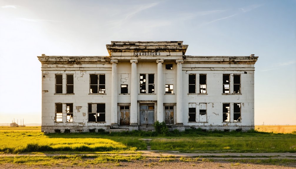
Arena: A Natural Valley Settlement Frozen in Time
When you crest the rolling hills thirty-five miles northeast of Bismarck, Arena appears below like a stage set abandoned mid-performance. The natural basin that inspired postmaster Harry A. Mutchler’s 1906 naming still cradles what remains: St. John’s Lutheran Church’s weathered steeple, twin grain elevators standing sentinel, and scattered structures resisting erasure.
You’re witnessing cultural preservation through benign neglect—no urban development will sanitize this authenticity. Founded by Patterson Land Company on railroad land, Arena peaked at 150 souls in 1920 before the Depression crushed it.
Arena’s authenticity survives precisely because progress forgot it—abandonment becoming the unlikely guardian of its Depression-era soul.
The post office survived until vandals torched it in 1996. The brick school building, constructed on a hill by 1930, was razed in the 1990s after decades of vacancy left it structurally unsound.
Spring transforms the valley into what those German immigrants and Mennonite farmers saw: boundless possibility. The church’s faded white paint peels in sheets, its supports sinking into basement darkness, yet it endures as the town’s spiritual anchor. You’ll find freedom here—from crowds, restrictions, and modern life’s relentless noise.
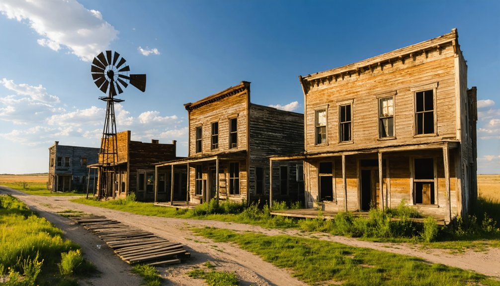
Sims: Where History Meets Haunting Legends
Travel thirty miles west from Arena and you’ll encounter something far more unsettling than simple abandonment. Sims welcomes you with its 1884 Scandinavian Lutheran Church, still hosting bi-weekly services, alongside a parsonage that’s become ground zero for ghostly legends.
The Gray Lady—reportedly Bertha, the minister’s wife who died here between 1916-1918—has driven pastors away since the 1930s. Congregation members once complained to their bishop about phantom organ music and self-opening windows.
During 2006 restoration work, volunteers heard distinct footsteps upstairs in the empty building. The restoration was funded by Preservation North Dakota alongside dedicated volunteers who worked through 2007.
Thanks to historical preservation efforts (including Laura Bush’s 2008 visit), you can explore this paradox: an active church surrounded by brick ruins and cemetery stones, where North Dakota’s mining boom meets unexplained midnight disturbances. Founded in 1883 as a coal town, Sims once boasted around 1,000 residents before declining to just 86 by 1910.
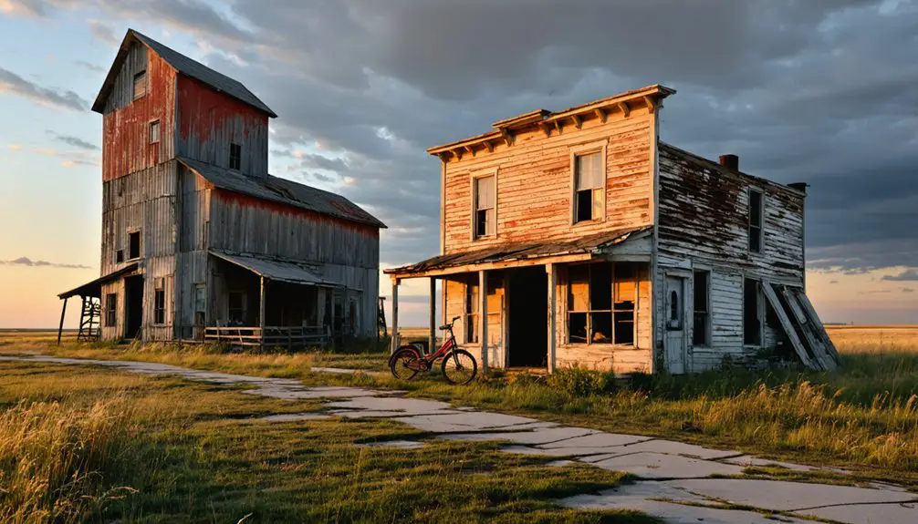
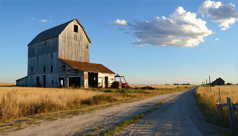
Charbonneau: Western North Dakota’s Authentic Ghost Town
You’ll find Charbonneau roughly fifteen minutes west of Watford City, accessible via State Highway 200 and a graded county road that tests your commitment to authentic ghost town exploration.
With zero residents since the 1960s, this isn’t a tourist trap—it’s genuinely abandoned, standing silent on private land where grain elevators and a crumbling schoolhouse mark where 125 people once called home. The town traces its origins to a Great Northern Railroad settlement in McKenzie County, named after nearby Charbonneau Creek.
The best window for visiting spans early summer when two-wheel-drive vehicles can handle the approach, though you’ll need to respect property boundaries and safety warnings posted around the deteriorating structures. On the hill entering from the north, you’ll find the historic cemetery containing graves of early settlers and their descendants who built this community in the early 1900s.
Remote Location and Access
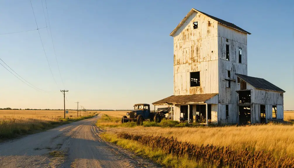
Tucked into the rolling hills of northwestern McKenzie County, Charbonneau sits roughly a mile south of Highway 200, where the prairie swallows it whole.
You’ll drive 5-6 miles west of US 85, then veer south onto a graded county road that follows an old Great Northern Railroad track. Your 2WD vehicle handles these roads fine—no need for heavy equipment.
The isolation rewards you. Local flora bursts alive in spring, painting the hillsides with wildflowers and prairie grasses.
Wildlife encounters happen frequently here: deer, pronghorn, and raptors claim this territory as their own.
At coordinates 47°51′12″N 103°45′48″W, you’re genuinely off the beaten path, about 18 miles south of Williston in one of North Dakota’s most sparsely populated corners. The name Charbonneau appears in multiple place references across North America, making this abandoned settlement a specific point of interest among similarly named locations.
Zero residents remain, leaving just you and the ghosts. Nearby landmarks include Bull Butte Peak and Nameless Cemetery, both located 3½ miles west of the townsite.
Zero Population Historic Site
When the Great Northern Railroad pushed through McKenzie County in 1913, Charbonneau sprang up as another hopeful prairie settlement named for the creek that bears Toussaint Charbonneau’s name—that unremarkable interpreter who married Sakakawea and joined Lewis and Clark’s expedition.
The town peaked at 125 souls in 1920, then hemorrhaged residents until the census stopped counting in 1960.
Today you’ll find zero population—officially confirmed—making this North Dakota’s most authentic ghost town. No urban development threatens its abandoned grain elevator, unsafe school building, or weathered post office. Unlike sites subjected to modern restoration, Charbonneau remains untouched on private land, fifteen minutes west of Watford City.
The railroad grade cuts through town, rails long gone, preserving the raw abandonment that draws freedom-seekers to genuine Western ghost towns.
Visiting Between 2010-2017
Between 2010 and 2017, Charbonneau existed in that perfect state of decay photographers dream about—abandoned enough to feel genuinely forsaken, yet intact enough to tell its story.
In 2010, John Piepkorn’s camera captured standing homes and barns weathering gracefully on the prairie.
By 2017, the Ghosts of North Dakota team found these same wooden structures still defying gravity, alongside a cemetery and farm remnants scattered across the grassland.
You’d find no urban development creeping toward this site, no modern amenities diluting its authenticity—just zero population and honest abandonment fifteen minutes west of Watford City.
Spring conditions during these years offered ideal exploration weather: minimal overgrowth, clear access via gravel roads, and structures frozen in time without vandalism disrupting their slow surrender to North Dakota’s elements. Unlike completely barren ghost towns that lack buildings and roads entirely, Charbonneau maintained physical remnants of its past. Like Sims with its active church and cemetery, Charbonneau retained structural remnants that anchored its historical identity to the landscape.
Sherbrooke: The Former County Seat That Lost Its Way
You’ll find it hard to believe that President William McKinley once slept here at the Sherbrooke House Hotel in 1896, when this Steele County seat bustled with promise.
The town’s fatal flaw wasn’t ambition—it was geography, as the lack of railroad access eventually strangled its economy and convinced voters to relocate the county seat to better-connected Finley in 1918.
Today, you can wander among field stone foundations and the charred remains of a two-story structure, plus spot an old Studebaker with suicide doors slowly rusting into the prairie.
Presidential Visit in 1896
During the height of Sherbrooke’s prominence as Steele County’s seat, presidential candidate William McKinley made a campaign stop in this bustling prairie town in 1896. You can imagine the excitement rippling through this frontier community when a future president arrived at their courthouse. The same historic architecture where residents gathered for church services and ice cream socials stood proudly.
Standing four miles west of neighboring farms, Sherbrooke represented everything these pioneers had built from scratch. Today, you’ll find only whispers of that momentous day, the kind of dinner ghost stories locals share about when their vanished town mattered enough to host presidential candidates.
It’s a powerful reminder that prominence doesn’t guarantee permanence on these unforgiving plains.
Railroad’s Impact on Decline
The railroad never came, and Sherbrooke’s fate was sealed. While neighboring towns embraced modern transportation infrastructure, you’ll find that Sherbrooke’s isolation became its death sentence.
In 1892, records already flagged the lack of rail as a fatal flaw—even the Supreme Court emphasized that county seats needed railroad or river access.
You can imagine the betrayal settlers felt when promised rail service never materialized. By 1918, voters weren’t fooled anymore. They chose Finley with its railroad connections, leaving Sherbrooke with less than 20% support.
Without transportation infrastructure, urban development was impossible. Businesses fled immediately after the 1919 county seat loss. The newspaper printed its final issue, houses were physically relocated, and by 1982, only two residents remained in this cautionary tale of isolation.
Remaining Structures Today
Standing alone in overgrown fields off Highway 6, Sherbrooke’s skeletal remains tell a haunting story of political defeat and mass exodus. You’ll discover structures nature’s aggressively reclaiming:
- Sherbrooke House Hotel ruins – field stone foundation where President McKinley stayed in 1896, now identified by charred timber and bed frames.
- Arlene Carpenter’s pink house – last occupied home abandoned in the 1980s, featuring Lizzie Devlin’s grotto with Blessed Virgin Mary statue.
- Two-room schoolhouse – operational until the county superintendent relocated.
- Stone foundations – possibly Tom Devlin’s home, scattered south of the main road.
The archaeological significance of these ruins faces severe preservation challenges. Dense brush and trees have infiltrated every structure since early 2003 visits.
You’re free to explore this zero-population ghost town, but time’s running out.
Tagus: a Convenient Day Trip From Minot
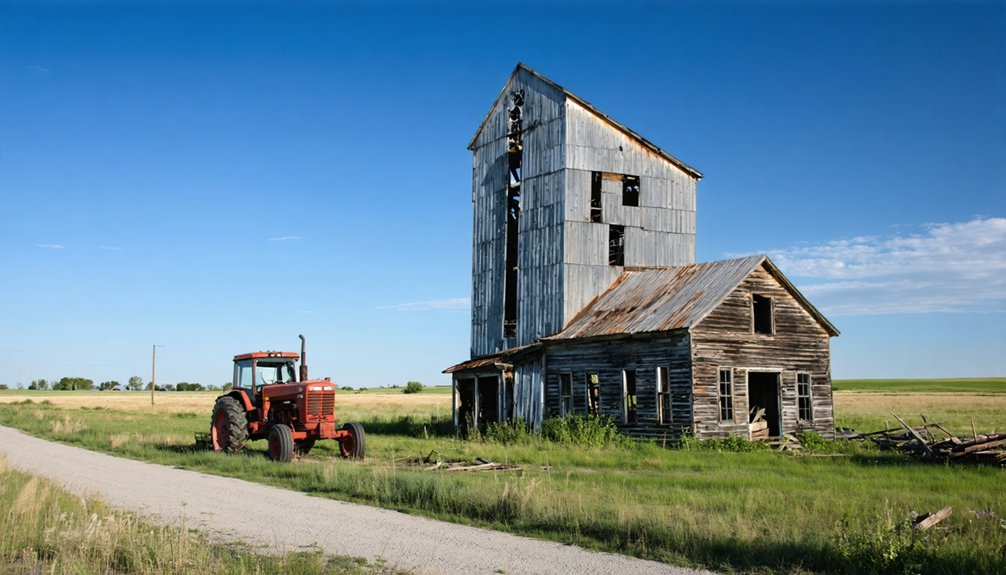
Just forty miles west of Minot along U.S. Highway 2, Tagus makes an ideal spring afternoon escape into North Dakota’s haunted past. You’ll spot the old rail car marking this former railroad settlement that once housed 140 souls.
Today, it’s practically empty—a handful of dilapidated structures scattered across rolling prairie alongside the Great Northern Railway route.
The drive takes less than an hour, giving you plenty of daylight to explore what remains.
Urban legends swirl around this ghost town: Satanic rituals, phantom trains, glowing gravestones.
Paranormal activities supposedly center on St. Olaf Lutheran Cemetery and the burned church site.
Whether you’re chasing ghost stories or simply craving wide-open solitude away from city constraints, Tagus delivers an eerie, unforgettable experience without requiring overnight planning.
Griffin: Yellowstone Trail’s Forgotten Stockyard Stop
Straddling the cattle-driving route between Bowman and Rhame, Griffin operated less as a proper town and more as a bustling stockyard hub where cowboys gathered, deals were struck, and—if local lore holds true—gunfights occasionally erupted.
Seven miles west of Bowman along Highway 12, you’ll find this true ghost town where historic preservation efforts haven’t reached.
What you’ll discover:
- The deteriorating Atkinson School building, one of four consolidated rural schools built in early 1920s
- A weathered boxcar and barn marking the former depot area
- Grain elevators standing 1/4 mile west
- Railroad tracks you’ll walk across (the road’s been removed)
No town reconstruction plans exist here—Griffin remains authentically abandoned, population zero, with only memories of the Yellowstone Trail passing two miles north.
Best Times to Explore North Dakota Ghost Towns in Spring
When spring arrives in North Dakota, ghost town exploration transforms from a frozen impossibility into a photographer’s dream—but timing matters more than you’d think.
Mid-April through mid-May offers your sweet spot. Roads dry enough for standard vehicles, yet summer crowds haven’t arrived. You’ll catch that amber-glow sunrise at 6 AM, illuminating weathered structures for fifteen hours of exploration time.
Mid-April through mid-May delivers firm roads, absent crowds, and fifteen glorious hours of golden light across North Dakota’s forgotten settlements.
Early spring reveals hidden foundations before vegetation obscures them, while wildlife migration adds unexpected encounters—though rattlesnakes emerge by late May. March keeps you highway-bound with ice; late May brings mosquitoes.
Target that golden window when muddy roads firm up but temperatures stay cool. You’ll have places like Sims Scandinavian Lutheran Church entirely to yourself, experiencing true solitude before tourist season locks you in.
What to Bring When Visiting Abandoned Settlements
Before you load the truck for North Dakota’s backcountry ruins, understand this: you’re packing for three distinct environments simultaneously. The urban decay you’ll photograph demands weatherproof gear—expect 30-60°F swings, prairie downpours, and wind that cuts through cheap layers.
Your essentials:
- Waterproof hiking boots with gaiters for muddy fields and debris-filled structures
- GPS device with offline maps since cell towers abandoned these places long ago
- Sturdy gloves and first aid kit for handling rusted metal without tetanus drama
- Camera gear with extra batteries because cold drains power faster than you’d expect
Pack lightweight but protective clothing—long pants guard against knee-high brush, while layered jackets handle morning frosts.
Preservation efforts mean respecting these sites, so bring bags for your trash. You’re documenting history, not adding to the decay.
Respecting History: Guidelines for Ghost Town Exploration
Your backpack’s loaded and your boots are laced, but proper gear means nothing if you can’t legally step foot on the property. Track down owners through county assessor records and get written permission—it’s your ticket to legitimate exploration.
When you’re standing in a crumbling homestead, remember ethical storytelling means photographing everything but taking nothing. Those rusted tools and weathered letters aren’t souvenirs; they’re pieces of lives once lived.
Artifact preservation depends on leaving items exactly where you found them. Pack out your trash, skip the graffiti, and don’t disturb what time has already claimed.
Check local trespassing laws, carry your permits, and stay respectful with any locals you encounter.
Real freedom comes from exploring responsibly.
Frequently Asked Questions
Are North Dakota Ghost Towns Safe to Visit With Children?
North Dakota ghost towns aren’t safe for children due to open basements, unmarked wells, and trespassing risks. You’ll face fall hazards hidden in tall grass, potential wildlife encounters, and crumbling structures despite historical preservation efforts. Permission’s required; landowners may confront trespassers.
Do I Need Permission to Enter Ghost Town Buildings?
Yes, you’ll need permission to enter most ghost town buildings since they’re private property, even if abandoned. Permission requirements protect both you and owners legally—always ask locals or landowners first before exploring any structures.
Can I Camp Overnight Near These Ghost Towns?
You can’t camp directly on ghost town sites due to historic preservation rules, but you’ll find dispersed camping on nearby BLM lands within 300 feet of roads—perfect for capturing stunning sunrise photography opportunities over abandoned structures.
Are There Guided Tours Available for North Dakota Ghost Towns?
You’ll find limited guided tours for North Dakota’s ghost towns—mostly self-guided exploration using GPS apps and websites with historical preservation details. Fargo offers walking tours focused on local legends and urban hauntings, but rural ghost towns require independent adventure.
In the warm glow of the sun, visiting ghost towns in North Dakota summers can be a captivating experience, revealing the remnants of once-thriving communities. As you wander through the deserted streets, the history of these locations unfolds, offering a glimpse into a bygone era. Each abandoned building tells a story, inviting exploration and reflection on the people who once called these places home.
What Cell Phone Coverage Can I Expect at These Locations?
Like a lighthouse guiding ships, cell towers reach these ghost towns with varying beams. You’ll find 70-100% signal strength near highways at Crystal Springs and Arena, while cell reception drops to 50-85% at remote Sims and Tagus.
References
- https://us1033.com/a-haunting-look-at-some-real-life-north-dakota-ghost-towns/
- https://northernsentry.com/2025/06/26/north-dakota-ghost-towns/
- https://ghostsofnorthdakota892857007.wordpress.com/2015/10/30/true-ghost-towns-population-zero/
- https://www.amyallender.com/north-dakota-ghost-towns/
- https://www.youtube.com/watch?v=8GO57Im_dss
- https://www.onlyinyourstate.com/experiences/north-dakota/ghost-towns-nd
- https://cdn.saffire.com/files.ashx?t=fg&rid=DickinsonCVB&f=DixCVB_Cemetery_Map.pdf
- https://www.quincyvagell.com/arena/
- https://www.legendsofamerica.com/arena-north-dakota/
- https://www.youtube.com/watch?v=JrbLsH8cdps