Planning a ghost town road trip to Brennan, South Dakota means stepping into the forgotten edges of Black Hills history. You’ll navigate rugged terrain from Rapid City via Highway 79, passing through land that once buzzed with frontier ambition. Bring high-clearance vehicles, paper maps, and plenty of water since cell service gets spotty fast. Visit between May and October for the best conditions. Keep exploring to uncover everything this haunting landscape has waiting for you.
Key Takeaways
- Brennan, South Dakota, founded in 1875 during the mining boom, is one of over 150 documented ghost towns in the state.
- Pair Brennan with nearby ghost towns like Ardmore, Tinton, Trojan, and Spokane for a comprehensive multi-day road trip itinerary.
- Travel via Highway 79 from Rapid City; high-clearance vehicles are recommended due to gravel and dirt road conditions.
- Visit between late spring and early fall, packing water, a first aid kit, paper maps, layered clothing, and sturdy boots.
- Lodging options include Rapid City hotels, Custer State Park cabins, Hot Springs bed-and-breakfasts, and dispersed camping on federal land.
What Is Brennan, South Dakota?
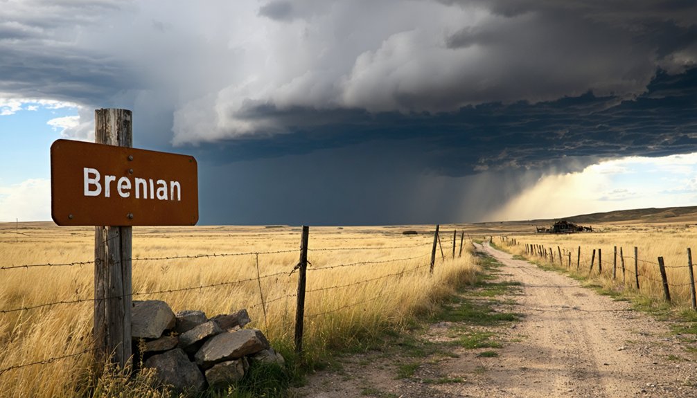
Nestled near the Black Hills region of South Dakota, Brennan is a minor community that’s easy to overlook on a map — but its ties to the area’s deeper history make it a compelling stop for ghost town enthusiasts.
Brennan history connects directly to John R. Brennan, who arrived in 1875 and shaped the founding of Rapid City nearby. The Black Hills drew waves of settlers chasing mining wealth, and small communities like Brennan emerged from that restless energy.
Today, you’ll find it sitting quietly on the edge of a landscape that once buzzed with ambition and opportunity. If you’re mapping out a road trip through South Dakota’s forgotten places, Brennan deserves a spot on your itinerary.
Where Brennan Fits in Black Hills Ghost Town History
When you explore the Black Hills, you’ll find that Brennan sits among over 150 documented ghost town locations scattered across South Dakota.
The region’s mining boom of the late 19th century gave rise to camps like Tinton, Spokane, and Trojan, each sharing a similar story of resource depletion and economic collapse.
Understanding Brennan’s place in this history helps you appreciate how interconnected these forgotten communities once were across the Black Hills landscape.
Brennan’s Black Hills Origins
Though it’s easy to overlook a minor community like Brennan, its roots run deep into the Black Hills’ turbulent 19th-century mining era—the same era that shaped dozens of now-forgotten settlements across South Dakota.
Understanding Brennan history means recognizing its mining significance within a broader landscape of boom-and-bust communities.
Picture yourself standing where early settlers once staked their futures:
- Dusty trails cutting through pine-covered ridgelines
- Makeshift camps buzzing with prospectors chasing fortune
- Abandoned shaft entrances disappearing into hillsides
- Hand-built structures weathered by decades of harsh winters
- Silence now replacing what was once relentless activity
Brennan emerged from this same restless energy.
It represents the freedom-driven spirit that pulled thousands westward—and the harsh reality that most mining dreams didn’t survive resource depletion.
Regional Ghost Town Context
Brennan doesn’t stand alone in South Dakota’s ghost town landscape—it shares company with over 150 documented abandoned settlements scattered across the state, many of them clustered within the Black Hills region.
Places like Tinton, Spokane, and Trojan each carry their own ghost town legends rooted in the same turbulent mining history that shaped Brennan. You’ll find these sites spread across rugged terrain, each telling a distinct story of boom, bust, and abandonment.
Ardmore sits at 43.02° N, 103.81° W, while Trojan rests further north near 44.33° N, 103.82° W—coordinates that turn a paper map into a genuine adventure route.
Understanding Brennan means recognizing this broader pattern: resource depletion, economic collapse, and forgotten ambitions that once pushed settlers deep into untamed Black Hills country.
Land Access Rules Before You Drive to Brennan
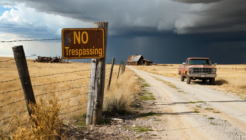
Before you load up the car and head toward Brennan, you’ll want to sort out the land access rules—because getting this wrong can turn an exciting ghost town adventure into an unwelcome confrontation.
Land permissions vary widely here, so follow these access guidelines carefully:
- Check county records to confirm whether your destination sits on public or private land.
- Respect every posted sign you encounter along rural roads and fence lines.
- Contact landowners directly before stepping onto private ranches or town lots.
- Stay on federal public land where no permission is required.
- Never assume open terrain means open access—fences exist for real reasons.
Freedom means respecting boundaries.
A quick phone call or records check keeps your road trip moving forward without unnecessary detours or legal trouble.
Getting to Brennan: Routes and Road Conditions
Getting to Brennan takes you through some of South Dakota’s most rugged and rewarding terrain, so you’ll want to plan your route carefully before you leave pavement behind.
Nestled near the Black Hills, Brennan sits along scenic routes that reward drivers with sweeping grasslands and pine-covered ridgelines.
From Rapid City, head south on Highway 79, then cut west on county roads toward the Black Hills fringe. Expect gravel and dirt surfaces that turn slick after rain, so a high-clearance vehicle gives you a real advantage.
Check road conditions with the county before you go.
Along the way, you’ll pass local attractions including historic markers and open ranchland that tell their own stories.
Give yourself extra time — this drive deserves it.
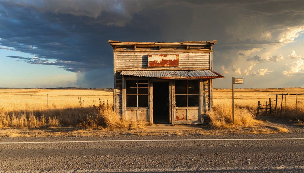
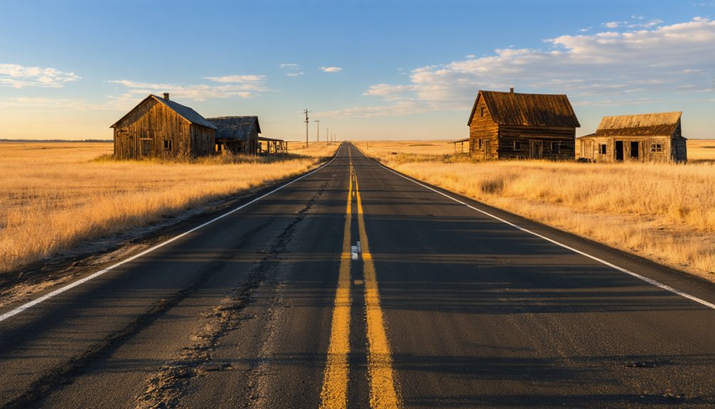
What You’ll Actually Find at Brennan Today
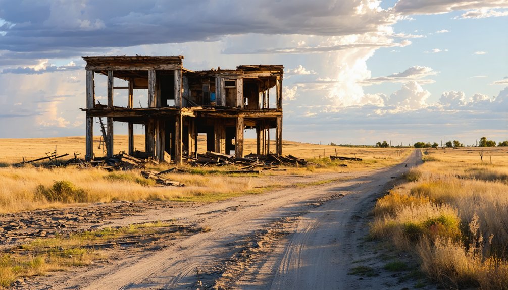
When you arrive at Brennan, don’t expect a bustling streetscape or dramatic ruins — what you’ll find is a quiet, scattered remnant of a community that time gradually left behind.
Brennan history lives in subtle details, and its mining heritage whispers through the landscape if you know where to look.
Here’s what you’ll likely encounter on the ground:
- Weathered foundation outlines barely visible beneath prairie grass
- Rusted metal fragments hinting at former structures and tools
- Open sky stretching endlessly over abandoned lot boundaries
- Faded tire tracks marking informal paths locals still occasionally use
- Silence broken only by wind cutting across the Black Hills terrain
Walk slowly, observe carefully, and respect any posted signs or private land boundaries you encounter.
The Best Nearby Ghost Towns to Pair With Brennan
If you’re already making the trek to Brennan, you’d be smart to build a longer route that hits several nearby ghost towns in one sweep.
Ardmore, sitting at 43.02° N, 103.81° W in Fall River County, pairs naturally with Brennan as a southern anchor, while Spokane in Custer County adds another stop along the way.
Trojan, recorded at 44.33° N, 103.82° W, rounds out a northern loop that keeps your road trip moving through the Black Hills‘ richest ghost town territory.
Nearby Ghost Town Locations
Since you’re already making the drive out to Brennan, pairing it with a few neighboring ghost towns turns a single stop into a full day of exploration.
The Black Hills region holds countless forgotten tales rooted in mining heritage, and these nearby coordinates put history within easy reach:
- Tinton – a former mining camp tucked deep within the Black Hills
- Ardmore – a quiet remnant sitting at 43.02° N, 103.81° W in Fall River County
- Spokane – a vanished Custer County settlement at 43.80° N, 103.41° W
- Trojan – ruins resting at 44.33° N, 103.82° W amid rugged terrain
- Gordon Stockade – a historic traveler’s stop connecting regional exploration routes
Always check land ownership beforehand and respect posted signs before stepping onto any site.
Pairing Routes With Brennan
Knowing where these ghost towns sit is one thing—plotting a smart route between them is what separates a frustrating day of backtracking from a seamless historical tour.
Start at Trojan near the northern coordinates, work south toward Brennan, then push toward Tinton to absorb the area’s mining significance firsthand. From there, swing toward Spokane before finishing at Ardmore in Fall River County.
This loop keeps your driving efficient while letting Brennan history anchor the journey’s midpoint. You’ll move through communities that rose and collapsed for the same economic reasons, making each stop feel connected rather than isolated.
Pack water, download offline maps, and respect posted signs along the way. A well-sequenced route transforms scattered ruins into a coherent story you’ll actually remember.
When Is the Best Time to Visit Brennan?
When should you plan your road trip to Brennan, South Dakota? Timing matters when you’re chasing open roads and ghost town history. The best seasons for visiting are late spring through early fall, when ideal weather keeps mountain passes clear and daylight stretches long.
Picture your journey unfolding like this:
- May and June bring wildflowers blooming across the Black Hills landscape.
- July and August offer warm, dry days perfect for outdoor exploration.
- September delivers crisp air and golden foliage framing abandoned structures.
- October provides dramatic skies and quieter roads with fewer travelers.
- Winter months create isolation and hazardous conditions best avoided.
You’ll want maximum daylight for traversing rural terrain and photographing historic remnants.
Plan your departure early, pack layers, and embrace the freedom of the open road.
What to Pack for a Brennan Ghost Town Road Trip
Packing smart makes the difference between a memorable adventure and a frustrating detour. Before you hit the road toward Brennan, gather your packing essentials with intention. Bring plenty of water, trail snacks, a first aid kit, and a paper map since cell service gets unreliable near the Black Hills.
Layer your clothing for shifting temperatures, and wear sturdy boots for uneven terrain. A camera captures the raw beauty of abandoned structures you’ll encounter along the way.
For safety tips, always tell someone your route before departing. Carry a flashlight, a charged portable battery pack, and basic tools in your vehicle.
Respect posted signs and never enter unstable structures. Freedom on the road means staying prepared so nothing slows you down.
Where to Stay When Visiting Brennan and Nearby Sites
Once your gear is loaded and your route is set, you’ll want a solid base camp lined up before you roll out toward Brennan and the surrounding Black Hills ghost town circuit.
Local accommodations and camping options range widely, giving you real flexibility:
Local accommodations and camping options range widely across the Black Hills, giving every type of traveler real flexibility.
- Rustic tent sites tucked inside Black Hills National Forest
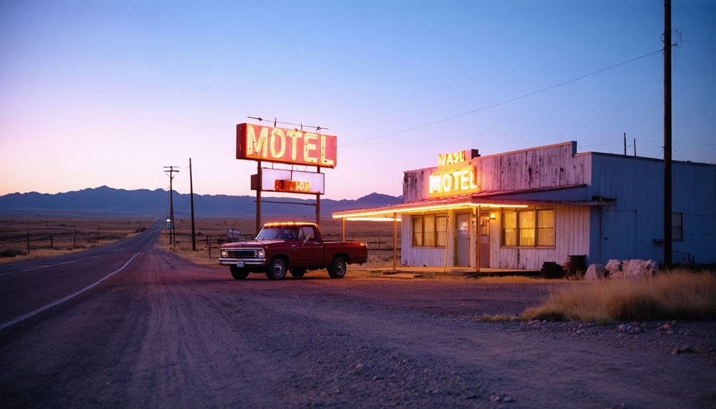
- Budget motels along Highway 16 near Rapid City
- Primitive dispersed camping on federal land close to historic coordinates
- Ranch-style bed and breakfasts offering authentic high-plains atmosphere
- Established campgrounds near Custer State Park with full hookups
Choose based on how deep you’re pushing into the backcountry. Staying closer to the sites cuts drive time and keeps your mornings free for exploration rather than road miles.
How to Build Your Full Brennan Multi-Day Route
Start your multi-day route by mapping the key ghost towns—Ardmore, Spokane, and Trojan—using their recorded coordinates to plot a logical driving sequence that minimizes backtracking.
You’ll want to plan each daily stop around travel distance and site accessibility, keeping in mind that some locations sit on private land requiring advance permission.
Lock in your overnight lodging early, since options near the Black Hills region fill quickly, especially during peak travel seasons.
Planning Your Daily Stops
How you sequence your daily stops can make or break a multi-day ghost town route through the Brennan area.
Prioritize ghost town photography during golden hour, and group stops by proximity to avoid backtracking across rugged terrain.
Consider anchoring each day around these five landmarks:
- Tinton: A former mining camp rich with Black Hills mining history
- Ardmore: Quiet ruins sitting at 43.02° N in Fall River County
- Spokane: A weathered Custer County remnant worth a full morning
- Trojan: Isolated coordinates at 44.33° N offering dramatic landscape shots
- Brennan: Your central hub connecting the surrounding ghost town corridor
You’ll move more freely when you respect posted signs, secure landowner permission early, and keep your itinerary flexible enough to chase the light.
Mapping Key Ghost Towns
Building your full Brennan multi-day route starts with laying out a reliable map that anchors each ghost town by its recorded coordinates. Pin Ardmore at 43.02° N, 103.81° W, Spokane at 43.80° N, 103.41° W, and Trojan at 44.33° N, 103.82° W.
These fixed points let you sequence stops efficiently, cutting unnecessary backtracking.
Once you’ve plotted coordinates, research each site’s preservation status. Some abandoned structures stand on public land, giving you open access, while others sit on private ranches requiring landowner permission.
Always respect posted signs.
Look for historical markers near each location — they’ll confirm you’ve found the right site and provide essential context about the mining-era communities that once thrived there.
A well-mapped route keeps your freedom intact while maximizing every mile you drive.
Overnight Lodging Options
Where you sleep each night shapes the entire rhythm of your Brennan multi-day route. Lodging options near the Black Hills range from rustic to comfortable, giving you flexibility to roam freely each day.
Pair your stay with local eateries, and you’ve got a grounded base for serious exploration.
Consider these lodging options along your route:
- Rapid City hotels offer modern amenities after long days on dusty roads
- Custer State Park cabins put you deep inside ghost town territory
- Hot Springs bed-and-breakfasts blend history with cozy overnight stays
- Dispersed camping on public land keeps costs low and skies wide open
- Private ranch stays connect you directly with the region’s living heritage
Each option positions you closer to the next forgotten town on your map.
Frequently Asked Questions
Are Photography Permits Required at South Dakota Ghost Town Sites?
You don’t always need permits, but you’ll want to follow ghost town etiquette. Respect posted signs, get landowner permission on private land, and use these photography tips: stay aware, shoot freely on public grounds!
Can Children Safely Explore Abandoned Structures at Brennan?
You shouldn’t let children freely explore abandoned structures at Brennan. Follow strict abandoned safety measures and children’s exploration guidelines: keep kids close, avoid unstable buildings, and always supervise their curiosity while embracing the freedom this historic site offers.
What Wildlife Hazards Exist Near Black Hills Ghost Town Locations?
You’ll encounter rattlesnakes, mountain lions, and black bears near Black Hills ghost town locations. Take wildlife encounters seriously by packing safety precautions like bear spray, watching your step, and staying alert while exploring these thrillingly remote, untamed landscapes.
Are Metal Detectors Allowed at South Dakota Ghost Town Sites?
You’ll need to check metal detector regulations before exploring, as rules vary by land ownership. Practice good ghost town etiquette—always get landowner permission on private grounds and respect federal agency guidelines on public sites.
Does Cell Service Exist Along Remote Black Hills Ghost Town Routes?
Communication can get “digitally sparse” in remote areas! You’ll find cell coverage plays hide-and-seek along Black Hills ghost town routes. Download offline maps before you venture out, ensuring your freedom to explore without losing your way.
References
- https://en.wikipedia.org/wiki/List_of_ghost_towns_in_South_Dakota
- https://en.wikipedia.org/wiki/Okobojo
- https://deutsch.wikibrief.org/wiki/List_of_ghost_towns_in_South_Dakota
- https://www.ghosttowns.com/states/sd/sd.html
- https://history.sd.gov/archives/docs/Brennan.pdf
- https://www.youtube.com/watch?v=_0WNYsFLSLA
- https://en.wikipedia.org/wiki/Category:Ghost_towns_in_South_Dakota
- https://core.ac.uk/download/pdf/345016075.pdf
- https://commons.wikimedia.org/wiki/Category:Ghost_towns_in_South_Dakota
- https://www.facebook.com/SoDakPB/videos/vanished-south-dakota-tinton/2392783747615624/


