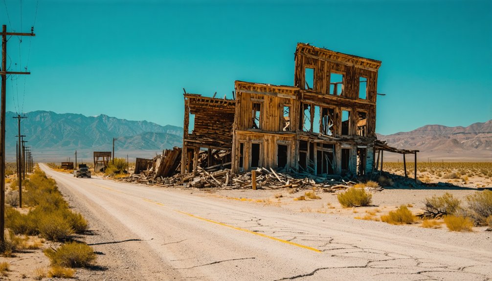
Eberhardt sits above 9,000 feet in Nevada’s White Pine Range, where silver fever once drew hundreds and left behind only stone foundations and silence. To get there, head to U.S. Highway 50, about 37 miles west of Ely, then climb into terrain that demands a high-clearance 4WD vehicle. Summer offers the safest access, but any season carries its own risks. There’s far more to this forgotten boomtown than a quick glance reveals.
Key Takeaways
- Eberhardt is located in the White Pine Range, Nevada, accessible via U.S. Highway 50, approximately 37 miles west of Ely.
- High-clearance 4WD vehicles with all-terrain tires are essential, as rocky switchbacks and steep grades exceed 9,000 feet elevation.
- Summer months offer the best road conditions, while winter visits risk closures; always verify conditions before departing.
- Pack layered clothing, sturdy boots, a topographic map, and a whistle, as cell service is likely unavailable on-site.
- Stay at least 10 feet from mine shaft openings, avoid unsupported tunnels, and supervise children and pets at all times.
What Makes Eberhardt Nevada’s Most Overlooked Ghost Town
While Nevada’s ghost towns like Bodie and Virginia City draw steady crowds, Eberhardt sits quietly forgotten in the White Pine Range, its silver-laden past buried beneath windswept stone foundations and scattered debris. Founded in December 1867 after striking remarkably rich silver ore, this remote settlement once housed 200 residents chasing fortune on Treasure Hill.
Eberhardt history reveals a town that burned bright and vanished fast. By 1897, only two souls remained. That arc of rise and ruin makes ghost town exploration here feel raw and unfiltered.
You won’t fight tour buses or pay admission fees. Instead, you’ll pick through broken china shards, photograph massive mill foundations, and peer into hazardous mine shafts on your own terms. Eberhardt rewards the curious traveler who prefers discovery over convenience.
The Silver Boom That Built: and Buried: Eberhardt
Eberhardt’s story begins with greed and geology colliding on Treasure Hill in December 1867. The silver discovery ignited a frenzy that built an entire world at 9,000 feet — then quietly erased it.
Greed and geology met on Treasure Hill in 1867 — and built a world that vanished just as fast.
The mining legacy unfolded in brutal stages:
- 1867 — Miners strike silver so rich the cave walls shimmer
- 1870–1871 — Stanford and International Mills rise, processing ore at full throttle
- 1880s — Population crumbles from 170 residents to near zero
- 1904 — The last lessee walks away, and silence reclaims the hill
You’re not just visiting ruins when you come here. You’re standing inside a cautionary tale — where fortune arrived overnight and vanished just as fast, leaving only stone outlines and wind.
Do You Have the Right Vehicle for the Eberhardt Road?
Before you chase Eberhardt’s ghost, make sure your vehicle can handle the challenge — only high-clearance trucks or SUVs should attempt the rough, rocky dirt road that climbs toward Treasure Hill.
The terrain is unforgiving, with loose stone, steep grades, and ruts that’ll punish anything riding low to the ground.
Add the unpredictable weather that sweeps across elevations pushing well above 9,000 feet, and you’re reminded that this forgotten silver camp doesn’t give itself up easily.
High-Clearance Vehicles Only
Getting to Eberhardt isn’t a casual Sunday drive—you’ll need a high-clearance vehicle to handle the rough dirt road that climbs steeply through the White Pine Range. The high clearance advantages become clear once the terrain turns unforgiving.
These vehicle recommendations will keep your journey moving:
- 4WD trucks power through rocky switchbacks without losing traction.
- lifted SUVs clear protruding boulders that would destroy a standard undercarriage.
- all-terrain tires grip loose gravel on the steep 11-mile climb toward the summit.
- skid plates protect essential components from hidden rocks scattered across the road.
Don’t gamble with a sedan or low-clearance crossover. The road demands respect, and the reward—a windswept hilltop frozen in 1880—belongs only to those who arrive prepared.
Rough Terrain Challenges
Once you leave the pavement behind near Illipah Reservoir, the road to Eberhardt tests your vehicle with every mile it climbs through the White Pine Range.
This rough road demands serious vehicle preparation before you ever turn the wheel toward Treasure Hill. You’re maneuvering rocky switchbacks, loose gravel, and steep grades that punish low-clearance cars without mercy.
The same rugged terrain that isolated these silver miners in the 1860s still guards the site today. Check your tires, suspension, and fuel before you go — there’s no help waiting at 9,000 feet.
Bring recovery gear if you have it. The freedom to roam this remote ghost town belongs to those who respect what the land requires and arrive ready for the climb.
Elevation and Weather Risks
Climbing past 9,000 feet into the White Pine Range means the weather can shift on you faster than the silver market crashed on Eberhardt’s miners.
Elevation challenges here aren’t suggestions — they’re the mountain’s terms. Before you roll out, prepare for what the summit demands.
- Check forecasts for White Pine County specifically, not just Ely.
- Pack layers — temperatures drop sharply even in summer.
- Watch for afternoon thunderstorms that materialize without warning.
- Never start the climb if skies are already threatening.
Weather precautions separate smart explorers from stranded ones.
The same harsh conditions that stripped Eberhardt’s buildings down to rock outlines will strip your plans bare just as fast.
Respect the elevation, and the mountain rewards you with unfiltered freedom.
How to Get to Eberhardt, Nevada
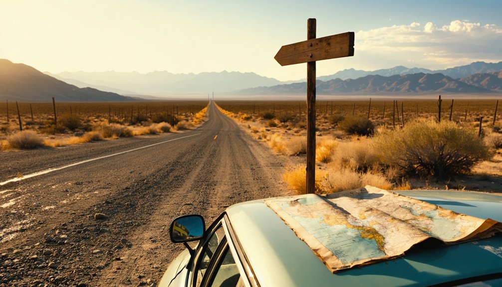
Reaching Eberhardt starts on U.S. Highway 50, approximately 37 miles west of Ely near Illipah Reservoir. Turn south onto a rough dirt road and prepare for serious terrain.
You’ll climb nearly 11 miles through the rugged White Pine Range toward Hamilton, then push onward to the windswept hilltop summit.
High-clearance vehicles aren’t optional here — they’re essential. The road demands respect, rewarding only those willing to earn the journey.
Come prepared or don’t come at all — Eberhardt’s roads demand high clearance and an unshakeable willingness to earn the view.
Once you arrive, Eberhardt history unfolds beneath your feet — crumbling mill foundations, scattered stone outlines, and hazardous mine shafts mark what was once a booming silver camp.
Ghost town exploration here feels raw and unfiltered, far removed from curated tourist trails. This is open land, quiet history, and complete freedom to roam.
When Can You Actually Access Eberhardt?
Timing your visit to Eberhardt matters more than most ghost town runs. High elevation and harsh winters make seasonal considerations critical for best visiting results.
Plan around these realities:
- Summer (June–August): Peak access window — roads dry, skies open, ruins fully explorable.
- Spring (April–May): Snow lingers at elevation; verify conditions before committing to that dirt road.
- Fall (September–October): Crisp air, dramatic light, and thinner crowds reward the prepared traveler.
- Winter (November–March): Road closures likely — the mountain doesn’t negotiate.
You’re chasing a place that outlasted its people but won’t forgive poor planning.
Check current road conditions through White Pine County before you roll out. Eberhardt rewards the ready and humbles the careless.
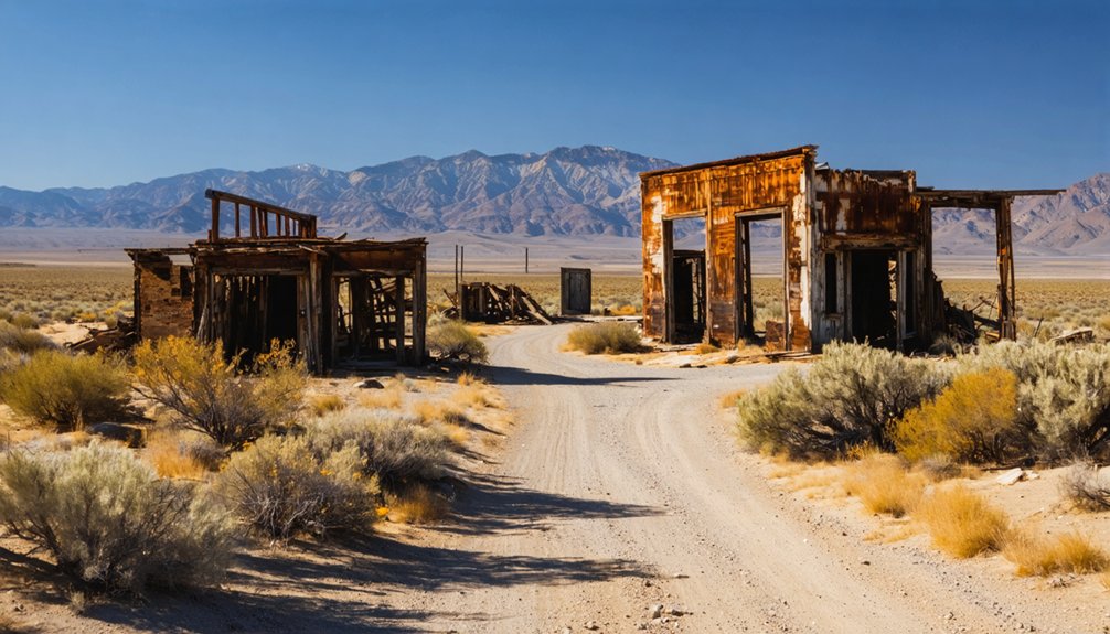
What’s Still Standing at the Eberhardt Site?
When you arrive at Eberhardt, the massive mill foundations hit you first — hulking stone remnants of the Stanford and International Mills that once processed some of the richest silver ore in the American West.
You’ll also trace the low rock outlines of former homes scattered across the windswept summit, ghostly footprints of the 200 souls who once called this harsh hilltop home.
Watch your step, though, because hazardous mine shafts and debris fields littered with rusted cans, broken glass, and fine china shards remind you that the ground here holds as many dangers as it does stories.
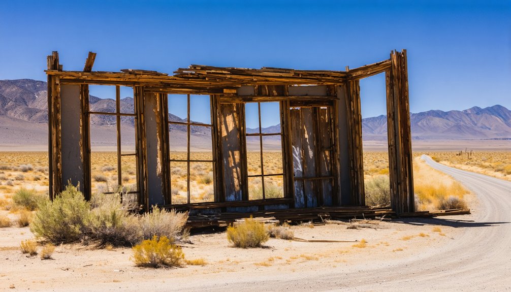
Mill Foundations Dominate Landscape
Massive mill foundations rise from Eberhardt’s windswept summit like the bones of an industry that once shook the American West.
Two giants defined this site’s mill history — and their stone remnants still command the landscape today.
Here’s what you’ll encounter during ghost town exploration:
- Stanford Mill foundations — completed fall 1870, now reduced to weathered stone outlines
- International Mill ruins — operational May 1871, rebuilt after an 1872 fire, finally closed in 1885
- Scattered building debris — rusted cans, broken glass, and fine china fragments frozen in time
- Hazardous mine shafts — open wounds in the earth demanding cautious, aware exploration
You’re walking through Silver Nevada’s industrial skeleton.
No ropes, no guided tours — just raw history beneath your boots.
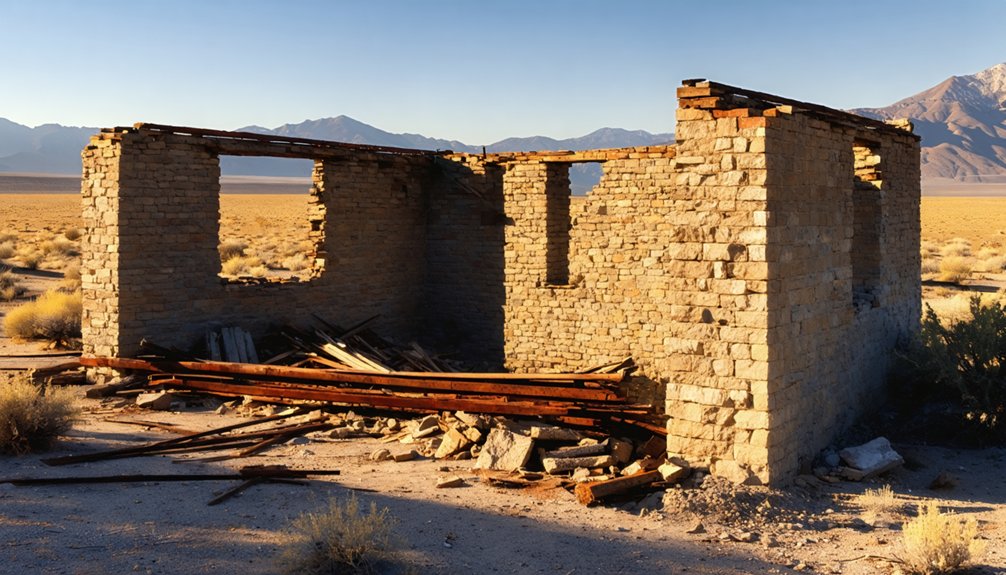
Stone Foundations Of Homes
Beyond the mill ruins, the summit opens into something quieter — the ghost of a neighborhood. Low rock outlines trace where families once lived, cooked meals, and weathered brutal winters at elevation.
You’ll walk between stone foundations that once anchored real homes during Eberhardt’s silver-rush peak, when roughly 200 residents called this windswept hilltop home.
The harsh climate has claimed every wall, every roof — but the footprints remain. For anyone serious about ghost town exploration, these foundations carry undeniable historical significance.
They’re not dramatic, but they’re honest. Each outline tells you exactly how small and deliberate life was up here.
Crouch down, trace the stonework with your eyes, and let yourself reckon with what people were willing to build — and abandon — in pursuit of silver.
Debris Fields And Shafts
Scattered across the summit, three types of hazards will stop you mid-step: open mine shafts, rusted debris, and broken glass hiding beneath the scrub. Debris exploration here rewards the careful and punishes the careless.
Before you wander freely, follow these shaft safety essentials:
- Never approach unfenced shaft openings — edges crumble without warning.
- Watch for rusted cans and metal fragments concealed beneath dry grass.
- Step deliberately around fine china shards and broken glass littering the ground.
- Keep children and pets close — hazards aren’t always visible until you’re too close.
These remnants aren’t random trash. They’re artifacts of 170 people who once called this windswept summit home.
Respect the ground beneath you, and it’ll reveal its stories honestly.
Hamilton, Treasure City, and the Ghost Towns Around Eberhardt
Eberhardt didn’t rise in isolation — it was one of several silver-boom towns that exploded across Treasure Hill in the late 1860s, and exploring the surrounding area reveals just how dramatic that short-lived frenzy truly was.
Hamilton History tells a familiar story: rapid growth, frantic wealth, then silence. Hamilton itself once served as the county seat, bustling with merchants and miners chasing fortunes just miles from Eberhardt.
Nearby Treasure City perched above 9,000 feet, where thin air and rich ore drew hundreds willing to endure brutal winters. Shermantown processed the district’s ore, completing a tight network of interdependent communities.
Today, you can wander between these scattered remnants, tracing ghost town clusters across the White Pine Range and piecing together one of Nevada’s most electrifying — and fleeting — silver rushes.
What to Pack for Eberhardt’s High-Elevation Terrain
Wandering those windswept ruins between Hamilton and Treasure City is thrilling, but the same high elevation and harsh conditions that emptied these towns can catch modern visitors off guard just as fast.
Smart packing essentials and terrain navigation gear separate a memorable adventure from a dangerous one.
Pack these four items before you leave:
- High-clearance vehicle — that rough 11-mile climb demands it.
- Layered clothing — summit temperatures drop without warning at 9,000 feet.
- Sturdy boots — hazardous mine shafts and debris fields punish casual footwear.
- Detailed topographic map — cell service won’t save you out here.
The miners who built Eberhardt respected this unforgiving landscape. You should too.
How to Stay Safe Around Abandoned Mine Shafts
Those hazardous mine shafts cutting into Treasure Hill’s silver-rich earth claimed lives during Eberhardt’s boom years, and they’ll do the same today if you’re careless.
Smart ghost town exploration means treating every dark opening in the ground as a genuine threat.
Smart ghost town exploration means treating every shadow, every silence, every dark opening as a genuine, life-threatening danger.
Never approach a shaft edge—the surrounding soil has weakened over a century of freeze-thaw cycles at this brutal elevation. Vertical drops here offer no second chances.
Follow these mine shaft safety essentials:
- Stay back at least 10 feet from any opening
- Never enter unsupported tunnels or adits
- Watch children and dogs constantly on the windswept summit
- Carry a whistle in case you stumble into unstable terrain
Eberhardt rewards the bold but punishes the reckless. Respect the mountain’s dangers, and you’ll leave with incredible stories intact.
Frequently Asked Questions
Is Camping Allowed Overnight at the Eberhardt Ghost Town Site?
The knowledge doesn’t confirm camping regulations or overnight permits for Eberhardt. You’ll want to contact Humboldt-Toiyabe National Forest directly before you chase those silver-dusted horizons and bed down among the ghost town’s windswept stone ruins.
Are There Any Guided Tours Available for Visiting Eberhardt Nevada?
Like a lone prospector charting unknown trails, you’ll find no formal guided tour options here. Eberhardt’s ghost town history is yours to freely discover, explore, and interpret entirely on your own adventurous terms.
Can You Find Silver Ore Specimens to Collect at Eberhardt?
You won’t find collectible silver ore specimens today, but geology enthusiasts can still walk grounds steeped in silver mining history, discovering scattered shards, stone ruins, and mine shafts that whisper of Eberhardt’s extraordinarily rich, once-glittering past.
Is Cell Phone Service Available Near the Eberhardt Ghost Town Site?
Don’t count on cell phone coverage out here — network reliability fades like the silver boom itself. You’re venturing into raw, untamed White Pine Range wilderness, where freedom means disconnecting from the modern world entirely.
Are Pets Allowed When Visiting Eberhardt Within Humboldt-Toiyabe National Forest?
By 1897, only two souls remained here. The knowledge base doesn’t specify pet safety rules or trail regulations for Eberhardt, so you’ll want to check directly with Humboldt-Toiyabe National Forest before bringing your adventurous companion.
References
- http://www.expeditionutah.com/forum/index.php?threads/ghost-town-eberhardt-white-pine-county-nevada.8148/
- https://forgottennevada.org/sites/eberhardt.html
- https://www.ghosttowns.com/states/nv/eberhardt.htm
- https://nvtami.com/2022/08/29/camping-with-the-godfather-of-ghost-towns/
- https://nevadamagazine.com/issue/july-august-2016/3558/
- https://www.ghosttowns.com/states/nv/nvwhitepine.html
- https://www.instagram.com/p/DMauyRyIRyP/
- https://nvtami.com/white-pine-county-nevada-ghost-towns/
- https://thecoinminer.com/Mining/NevadaMining/nevada_ghost_towns.htm
- https://www.nevadaghosttownsandmininghistory.com/copy-of-lincoln-county


