Plan your ghost town road trip to Independence, Colorado, by heading southeast from Aspen along Highway 82, part of the stunning Top of the Rockies Scenic Byway. You’ll find this once-thriving boomtown sitting at nearly 11,000 feet, where 1,500 residents struck gold on July 4, 1879. Visit between Memorial Day and October before the pass closes for winter. Pack layers, water, and sturdy shoes — there’s far more to this forgotten mountain town than first meets the eye.
Key Takeaways
- Independence, Colorado sits at nearly 11,000 feet elevation, located 16 miles southeast of Aspen along Highway 82’s scenic byway.
- Visit between Memorial Day and October, as Independence Pass closes during winter due to heavy snowfall.
- The townsite features log cabins, a general store, a stable, and the historic Farwell Stamp Mill with interpretive signs.
- Admission operates on an honor system, costing $5 per adult, with children admitted free of charge.
- Pack layers, water, sturdy shoes, and sun protection, and download offline maps due to unreliable cell service.
What Makes Independence, Colorado Worth the Drive?
When you make the climb up Highway 82 toward Independence Pass, you’re not just gaining elevation — you’re closing in on one of Colorado’s most compelling ghost towns, frozen at nearly 11,000 feet.
Independence boomed fast after a gold strike on July 4, 1879, swelling to 1,500 residents and 40 businesses before collapsing just as quickly. That raw rise-and-fall story hits differently when you’re standing among the actual ruins.
The mining heritage here isn’t behind glass — it’s underfoot, in the collapsed cabins and the weathered stamp mill still holding its ground.
The history here isn’t preserved behind glass — it’s crumbling beautifully beneath your feet.
Add in the surrounding scenic views of the Rockies at their most dramatic, and you’ve got a stop that delivers both history and pure mountain freedom in a single, unforgettable stretch of road.
When to Visit Independence and How to Get There
Getting to Independence is half the adventure, but timing your trip is what makes it possible at all. Independence Pass closes every winter under heavy snow, so your window runs from roughly Memorial Day through October.
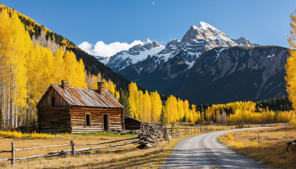
That’s your best season — aim for summer or early fall when the high-altitude air is crisp and the aspen trees begin turning gold.
Your route follows Highway 82, one of Colorado’s most breathtaking scenic routes, winding between Aspen and Leadville along the Top of the Rockies Scenic Byway.
The townsite sits about 16 miles southeast of Aspen near 11,000 feet. Park at the trailhead and walk the short dirt path into what remains of a boomtown that once held 1,500 souls.
Always check road conditions before you leave — the pass doesn’t forgive poor planning.
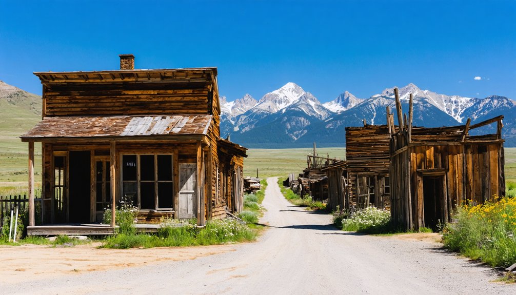
What’s Left of the Town Today?
A handful of log cabins and ruins are all that remain of Independence today, but they carry the weight of the town’s brief, turbulent life remarkably well.
You’ll walk a short dirt trail past town remnants including a general store, stable, and several weathered houses. The Farwell Stamp Mill stands as one of the most striking survivors, a raw reminder of the machinery that once processed gold ore at nearly 11,000 feet.
Interpretive signs throughout the site connect you to the historical significance of each structure, helping you picture a boomtown of 1,500 people and 40 businesses.
Interpretive signs bring each crumbling structure to life, conjuring a once-thriving boomtown of 1,500 souls.
Admission runs on an honor system — just $5 per adult, kids free. Leave dogs behind, stay on marked trails, and let the ruins speak for themselves.
What It Costs, What’s Allowed, and What to Pack
Visiting Independence costs next to nothing — $5 per adult, kids 18 and under free — collected through an honor-system donation box at the trail entrance.
That cost breakdown won’t strain any travel budget, leaving more room for adventure elsewhere on the pass.
Leave your dog behind; they’re not permitted on the townsite. Respect the ruins, stay on marked trails, and treat this archaeological preserve the way it deserves.
For packing essentials, think layers — elevation hovers near 11,000 feet, and mountain weather shifts fast.
Bring water, sturdy shoes, and sun protection. A light rain jacket earns its weight.
Cell service is unreliable, so download offline maps beforehand. Arrive prepared, and Independence rewards you with raw history and high-country freedom.
How to Make Independence the Centerpiece of an Independence Pass Road Trip
Once you’ve got the practical details sorted, building a road trip around Independence Pass becomes the easy part.
Drive Highway 82 between Aspen and Leadville, and you’re already on the Top of the Rockies Scenic Byway, one of Colorado’s most rewarding mountain routes.
Highway 82 between Aspen and Leadville isn’t just a road — it’s one of Colorado’s most rewarding mountain drives.
Stop at the summit for scenic viewpoints that stretch across the Sawatch Range, then descend to the townsite where the historical significance of an 1879 gold strike still lingers in every collapsed cabin wall.
You’re moving through a landscape that swallowed ambition whole.
Plan your visit for summer or early fall, check pass conditions before you leave, and give yourself at least an hour at the townsite.
The road rewards the curious traveler who refuses to rush.
Frequently Asked Questions
Was Independence, Colorado Originally Called Something Else Before Its Renaming?
Like a pioneer staking fresh claim, you’ll find Independence’s Historical Origins rooted in “Belden tent camp.” Name Changes followed fast — after gold struck July 4, 1879, freedom-seekers renamed it Independence, forever marking that bold discovery.
How Many People Lived in Independence at Its Peak Population?
At its peak, you’d have found roughly 1,500 souls thriving there! Independence’s mining history powered explosive growth, transforming wilderness into a bustling hub. Today, ghost town tourism lets you walk those same legendary streets freely.
What Specific Event Caused the Last Residents to Finally Leave Independence?
A brutal 1899 storm sealed Independence’s fate — you can almost feel the ghost stories it left behind. When food ran dry after the mining boom faded, the last survivors finally abandoned their frozen, wind-battered homes forever.
What Year Did Independence Become Completely Vacant and Abandoned?
By 1912, Independence’s ghost town history was complete — you’d find nothing but silence where 1,500 souls once thrived. Its mining legacy faded fast, leaving abandoned ruins that still call to your adventurous spirit today.
Is Independence, Colorado Listed on the National Register of Historic Places?
Independence’s historic significance earned it a spot on the National Register of Historic Places. You’ll explore this remarkable ghost town knowing it’s officially recognized as a treasured piece of Colorado’s wild, gold-rush past.
References
- https://www.uncovercolorado.com/ghost-towns/independence/
- https://en.wikipedia.org/wiki/Independence
- https://theclio.com/entry/48572
- https://www.youtube.com/watch?v=PfCxyYXXCM4
- https://thegenxtravels.com/2021/02/18/independence-ghost-town-colorado/
- https://www.explore.com/1704724/get-lost-mysterious-colorado-independence-ghost-town-history-ruins/
- https://coloradostories.online/f/independence-ghost-town
- https://www.youtube.com/watch?v=wTuh_zdfM5g
- https://www.youtube.com/watch?v=I23_QiXQx4M
- https://www.tripadvisor.com/Attraction_Review-g29141-d144371-Reviews-Independence_Ghost_Town-Aspen_Colorado.html


