Planning a ghost town road trip to Mormon Island means chasing a Gold Rush boomtown that’s been sleeping beneath Folsom Lake since 1955. You’ll want to monitor the lake’s water levels carefully, since drought conditions are your only ticket to seeing the submerged ruins resurface. Start at Folsom Lake Marina and time your visit for late summer or early fall. There’s far more history, mystery, and discovery waiting ahead than you’d expect.
Key Takeaways
- Mormon Island, a Gold Rush settlement founded in 1853, was submerged by Folsom Lake in 1955 after completion of Folsom Dam.
- Ruins become visible during severe drought conditions, with notable resurfacing occurring in late 2013, 2015, and 2021 due to record low water levels.
- Begin your visit at Folsom Lake Marina, approximately half a mile west of Browns Ravine boat docks, with nearby parking available.
- Plan visits during late summer or early fall for optimal chances of seeing exposed foundations, monitoring lake levels beforehand.
- Extend your trip by exploring 75 miles of shoreline trails, including Browns Ravine Area, which connects hikers directly to ghost town ruins.
What Is Mormon Island and How Did It End Up Underwater?
Mormon Island wasn’t always a ghost town — it was once a booming Gold Rush settlement that drew thousands of fortune-seekers to California’s American River. Founded in 1853 by Mormon Battalion members, the town swelled to roughly 2,500 residents at its peak, supporting four hotels, five merchandise stores, and three dry goods outlets.
Then progress swallowed it whole. When Folsom Dam‘s construction completed in 1955, rising waters buried Mormon Island entirely beneath what became Folsom Lake.
Today, its underwater history rests at depths reaching 381 feet during normal water levels.
You won’t find it on any active map, but Mormon Island still exists — quietly waiting beneath the surface, its foundations and forgotten streets occasionally re-emerging during severe droughts to remind you that some stories refuse to stay buried.
How Mormon Island Became a Gold Rush Boomtown
Before the waters rose and silence took over, Mormon Island was alive with ambition, gold dust, and the kind of restless energy that defined California’s earliest days.
Members of the Mormon Battalion first struck gold near the south fork of the American River in March 1848, igniting a rush that transformed a simple riverbank into a thriving settlement.
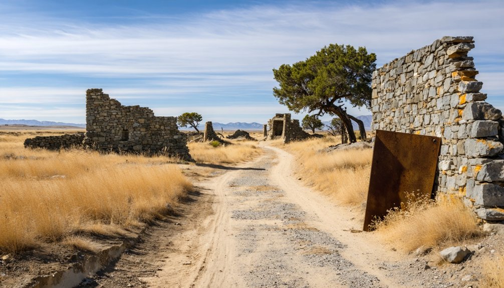
What Can You Actually See at Mormon Island’s Ruins?
When the lake recedes far enough, you’ll find yourself walking through what feels like a dream—ruins of building foundations etched into the earth, arched bridge sections emerging from the mud, and scattered fragments of broken pottery and rusty nails that once belonged to real lives.
The ghost town artifacts here carry genuine historical significance, connecting you directly to the 2,500 souls who once built hotels, stores, and homes on this very ground.
You’ll spot door hinges half-buried in silt, ceramic fragments from forgotten kitchens, and foundation outlines stretching roughly half a mile west of Browns Ravine boat docks.
When Does Mormon Island Surface During Droughts?
Seeing those artifacts scattered across the lakebed naturally raises a question—how often does Mormon Island actually break the surface? The answer depends entirely on drought conditions gripping California.
The ruins first resurfaced in late 2013, reappeared in 2015 when lake levels hit record lows, and emerged again in 2021. These windows aren’t guaranteed—they’re rare gifts that drought reluctantly offers.
When Folsom Lake drops considerably, the outskirts of this Gold Rush settlement slowly rise from the waterline, its historical significance suddenly tangible rather than theoretical. You’re fundamentally watching time reverse itself.
Your best strategy is monitoring Folsom Lake’s water levels before planning your visit. California drought cycles are unpredictable, so when levels plummet, move fast—Mormon Island won’t stay exposed forever.
How Do You Get to the Mormon Island Ruins?
You’ll want to head to Folsom Lake Marina, where a 2WD-accessible road grid puts you within striking distance of the ruins, roughly half a mile west of Browns Ravine boat docks.
Timing your visit around severe drought periods gives you the best chance of seeing exposed foundations, bricks, and artifacts that normally rest beneath 381 feet of water.
Once you’re on site, stick to photographing what you find — preservation guidelines prohibit removing anything from this hauntingly preserved slice of Gold Rush history.
Finding The Entry Point
Getting to Mormon Island isn’t complicated, but it does require knowing where to look. Your entry access begins at Folsom Lake Marina, where a 2WD-accessible road grid leads you toward the ruins sitting roughly half a mile west of Browns Ravine boat docks.
Plug these coordinates directly into your GPS: 38°42’12.60″N, 121°7’2.64″W. That’ll put you exactly where you need to be without second-guessing yourself on unmarked roads.
Parking options are available near the marina, giving you a straightforward starting point before you set off on foot toward the exposed foundations.
Just remember — lake levels dictate what you’ll actually find. Come during severe drought conditions, and those submerged streets from 1853 reveal themselves like an old secret finally surfacing for air.
Best Time To Visit
Knowing where to go only gets you halfway there — timing is everything with Mormon Island. The ghost town only reveals itself when Folsom Lake drops to critically low levels during severe drought periods.
You can’t schedule this trip like an ordinary vacation — you’ll need to monitor lake levels and watch drought reports closely before committing.
Your best visiting window typically falls during late summer or early fall when water levels naturally dip. Drought years like 2013, 2015, and 2021 offered the clearest access to foundations, brickwork, and artifacts.
Check California’s Department of Water Resources for real-time lake elevation data before heading out. When the conditions align, don’t hesitate — the lake can rise again quickly, swallowing those weathered ruins back into silence for years.
Finding Mormon Island takes just a few key navigational anchors. Head to Folsom Lake Marina in Sacramento County, where a 2WD-accessible road grid leads you toward this submerged ghost town‘s outskirts.
From there, walk approximately half a mile west of Browns Ravine boat docks. The ruins stretch quietly along the shoreline, waiting for you to discover them.
Keep these navigational details close:
- Coordinates: 38°42’12.60″N, 121°7’2.64″W pinpoints the heart of this Mormon history site
- Landmark: Browns Ravine boat docks serve as your most reliable reference point
- Access road: Standard 2WD vehicles handle the entry grid without difficulty
Once you’re there, let the exposed foundations, broken pottery, and arched bridge sections speak for themselves.
This ghost town rewards the curious and the free-spirited equally.
What Else Is Worth Doing After You Visit Mormon Island?

After you’ve walked the ghostly outlines of Mormon Island, don’t rush off — Folsom Lake’s 75 miles of shoreline offer hiking, swimming, and fishing that’ll keep you exploring for hours.
History buffs won’t want to miss the nearby prison, where a legendary musician once recorded a famous live album, turning those stone walls into something almost mythic.
You’ll find the whole area rewards slow travel, whether you’re lacing up boots for a trail or simply sitting with the strange, layered weight of what this landscape has swallowed and occasionally gives back.
Explore Folsom Lake Shoreline
Folsom Lake’s 75 miles of shoreline offer far more than a backdrop to Mormon Island’s sunken ruins. Shoreline exploration here means genuine freedom — open trails, shifting landscapes, and unfiltered California sky.
Wildlife observation rewards patient visitors with herons, ospreys, and deer moving through oak-studded hills.
Make the most of your time along the water:
- Hike the exposed lakeside trails where drought-revealed terrain creates constantly changing scenery
- Fish or swim from uncrowded coves tucked between the lake’s quieter northern reaches
- Watch for seasonal wildlife concentrated near shoreline vegetation, especially during early morning hours
This lake carries history beneath its surface and wildness along its edges. You don’t just visit Folsom Lake — you feel it pulling you toward something older and freer.
Visit The Historic Prison
Just a short drive from Mormon Island’s sunken past sits Folsom State Prison — the legendary institution where Johnny Cash recorded his iconic 1968 live album, cementing both the man and the place in American cultural memory.
The prison’s history runs deep, stretching back to 1880, making it one of California’s oldest correctional facilities. You won’t tour the active prison itself, but standing outside those granite walls carries its own quiet weight.
Cash sang to men who’d lost their freedom, and his words still echo across this landscape. After wandering Mormon Island’s drowned ruins, this stop completes something profound — a road trip threading together Gold Rush ambition, submerged history, and the haunting reminder of what freedom truly means when it’s gone.
Hike Nearby Recreational Trails
Stretching 75 miles around Folsom Lake, the shoreline hiking trails offer something Mormon Island itself can’t — solid ground beneath your feet and a living landscape to walk through.
Nature exploration here feels earned, especially knowing what lies beneath the water’s surface.
Pack light and roam freely along routes that reward curiosity:
- Granite Bay Trail – Wide, open paths ideal for reflective walks with sweeping lake views
- Browns Ravine Area – Positioned near the ghost town ruins, connecting history to wilderness
- Peninsula Campground Loop – Quieter stretches perfect for those craving solitude and space
You’re not just hiking — you’re moving through layers of California history.
The trails remind you that while Mormon Island sleeps underwater, the land surrounding it still breathes.
Frequently Asked Questions
Are Visitors Allowed to Take Artifacts Found at Mormon Island Ruins Home?
You can’t take artifacts home — preservation guidelines require you to photograph only. Respect artifact preservation and historical significance; these remnants of Mormon Island’s Gold Rush legacy don’t belong to one person — they’re everyone’s shared, timeless heritage.
How Much Gold Remains Undiscovered Beneath Mormon Island Today?
You’d be amazed — experts estimate miners only extracted 10% of available deposits, meaning 90% of hidden treasures still lie waiting. Gold prospecting dreams live on beneath those waters, where untold wealth remains forever submerged.
Who Were the Earliest Known Settlers to Arrive at Mormon Island?
Among 2,500 peak settlers, you’ll find the earliest known early settlers were W. Sidney, S. Willis, and Wilford Hudson, arriving from Sutter’s Fort—their historical significance shaping Mormon Island’s bold, freedom-seeking Gold Rush legacy forever.
How Many Hotels and Stores Did Mormon Island Have at Peak?
At its peak, you’d have found four hotels and eight stores showcasing Mormon Island’s historical significance. These thriving establishments fueled the town’s vibrant mining techniques culture, evoking a nostalgic era of freedom and golden opportunity.
What Exact Coordinates Pinpoint the Mormon Island Ruins Location?
Forget your treasure map! You’ll find Mormon Island’s historical significance pinpointed at exactly 38°42’12.60″N, 121°7’2.64″W — where California’s submerged ghost town awaits your free-spirited exploration beneath Folsom Lake’s waters.
References
- https://www.deseret.com/2022/10/8/23393357/mormon-island-ghost-town/
- https://www.ldsliving.com/ghost-town-mormon-island-ruins-exposed-in-california-due-to-drought/s/94539
- https://www.ghosttowns.com/states/ca/mormonisland.html
- https://en.wikipedia.org/wiki/Mormon_Island
- https://myfamilytravels.com/the-california-recreation-area-named-for-a-drowned-gold-rush-town-and-a-main-street-lost-to-the-deep/
- https://www.ldsliving.com/3-underwater-mormon-ghost-towns-you-can-see-today/s/82896
- https://www.youtube.com/watch?v=_HzKTSRR7IQ
- https://www.hcn.org/issues/46-7/a-long-submerged-town-becomes-visible/
- https://www.onlyinyourstate.com/state-pride/california/underwater-city-in-norcal
- https://raisethestakeseditions.com/mormon-island/


