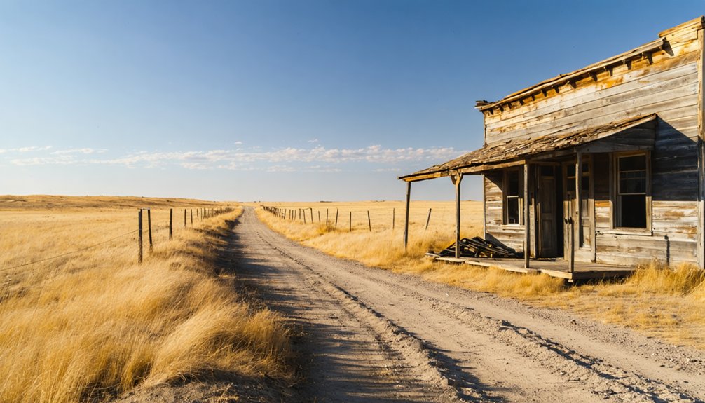
Planning a ghost town road trip to Preston, South Dakota means heading into the Black Hills just north of Lead, where the ruins of a gold rush still cling to the slopes of Ragged Top Mountain. You’ll find crumbling structures, scattered mining artifacts, and the quiet weight of a town that once boomed on $2,000-per-ton ore. Spring through fall offers the best access on standard 2WD roads. There’s far more to this forgotten place than first meets the eye.
Key Takeaways
- Preston, South Dakota, was a gold mining settlement near Ragged Top Mountain that thrived in the late 1800s before being abandoned.
- Key remnants include the Ragged Top School, a three-story hillside house, mining artifacts, and eroded tailings from the gold rush era.
- Stay safe by keeping 200 feet from mine shafts, avoiding soft ground, and keeping children and pets close while exploring.
- Preston is accessible via standard 2WD vehicles in dry conditions; avoid winter visits due to snow-blocked roads.
- Pair your Preston visit with nearby Deadwood and Lead, and explore ghost towns like Balmoral, Cyanide, Dacy, and Victoria.
What Made Preston, South Dakota a Ghost Town
Preston didn’t die quietly—it burned out fast, like most Black Hills mining towns built on boom-era gold fever. Settled around 1897 near Ragged Top Mountain, it thrived while the Spearfish Mine pulled gold from the earth and the Spearfish Gold Mining and Milling Company kept operations running.
The Ulster Mine, just a mile north, produced ore assaying up to $2,000 per ton—serious money that drew serious ambition. But mining decline hit hard once the shallow deposits played out. No ore meant no workers, no workers meant no town.
That’s the brutal logic behind ghost town evolution in the Black Hills. Preston followed that same trajectory, leaving behind a scattered handful of structures and the quiet weight of a community that once believed it had found something permanent.
The Gold Mining History Behind Preston’s Rise and Collapse
Gold built Preston, and gold buried it. When miners discovered rich ore near Ragged Top Mountain around 1897, an economic boom pulled settlers, workers, and capital into the Black Hills fast.
The Spearfish Mine alone produced over 48,000 ounces of gold between 1899 and 1906, and the Ulster Mine, just a mile north, reportedly yielded ore assaying up to $2,000 per ton.
That kind of output shaped the settlement patterns of the entire district, creating a mining community with real infrastructure — mills, roads, and neighboring towns like Cyanide and Balmoral.
But ore extraction eventually slowed, the ground gave less, and Preston emptied out.
Today, its historical significance lies in what it shows you: how quickly a ghost town rises, and how quietly it falls.
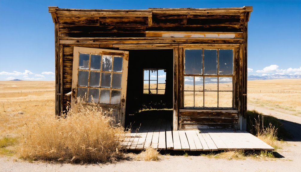
What Still Stands at the Preston Townsite Today
What’s left at the Preston townsite isn’t much, but it’s enough to anchor your imagination to the boom years. Historic preservation here is minimal, yet the remnants speak clearly if you slow down and look.
You’ll find:
- Ragged Top School, one of the few standing structures with documented history
- A deserted three-story house, weathered but still upright against the hillside
- Mining artifacts scattered across the landscape, connecting you directly to the extraction era
- Mine waste and eroded tailings, raw evidence of the frantic gold rush activity that built and buried this place
Walk the site on your own terms. Nobody’s curating this experience for you.
Preston rewards the curious traveler who’s willing to read a landscape rather than a placard.
How to Find Preston Near Lead, South Dakota
Finding Preston takes a little local knowledge, but the landmark that’ll orient you fastest is the Wharf Mine on the north edge of Lead—Preston sits just beyond it.
Before heading out, stop in Lead and ask locals for current directions, since road conditions can shift dramatically after rain, turning accessible gravel routes into muddy obstacles.
Most sources list the approach as manageable in a standard 2WD vehicle during dry conditions, so you won’t need heavy equipment to reach a site of genuine historical significance.
Avoid winter visits entirely, as snow closes off access and obscures the remnants worth seeing. Spring, summer, and fall all work well.
Terry Peak ski area serves as another useful geographic reference point if you’re guiding from the surrounding hills.
When to Visit Preston and What the Roads Are Like?
Once you know where Preston sits on the map, timing your visit becomes the next thing that shapes the whole experience.
Knowing where Preston sits is only half the work—when you show up shapes everything that follows.
For best visiting, skip winter entirely—snow closes the roads and buries whatever history remains above ground.
Road conditions vary depending on when you roll in:
- Spring and fall offer cooler temperatures and manageable dirt roads
- Summer keeps things warm and accessible, with longer daylight for exploring
- Winter brings snow that blocks access and complicates every mile
- Wet weather turns gravel and dirt sections slick regardless of season
Most approaches handle standard 2WD vehicles when conditions are dry.
Rain changes that quickly. Check the forecast before you head out from Lead, and you’ll stay ahead of any trouble the road throws at you.
The Ragged Top School and Structures Still Standing on Site
Stepping onto the Preston site, you’ll find the Ragged Top School standing as the most recognizable landmark still holding its shape against the surrounding decay. It’s a rare example of historic preservation in a landscape where most structures have surrendered to time and weather.
Beyond the school, a deserted three-story house rises unexpectedly from the hillside, its frame still intact despite decades of neglect. These remaining structures give you a tangible connection to the community that once thrived here during the gold rush era.
Walk the grounds carefully. You’ll notice foundations, scattered debris, and graded earth that once supported buildings long since collapsed. Each remnant tells part of Preston’s story.
The Ragged Top School anchors the site, but the full picture emerges when you take in everything still standing around it.
Abandoned Shafts and Site Hazards at the Preston Townsite
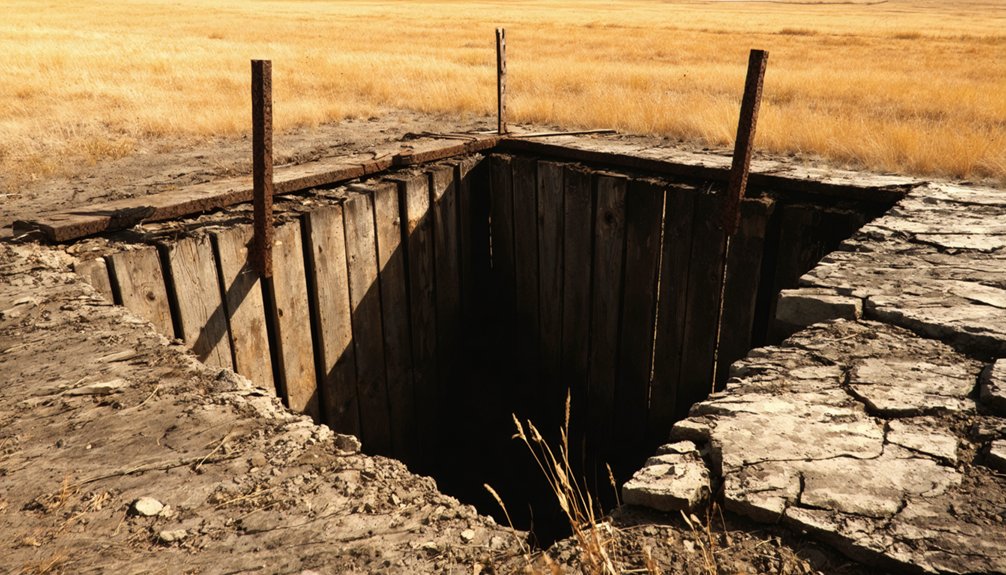
As you explore the Preston townsite, you’ll want to keep a sharp eye out for abandoned mine shafts, which can be hidden beneath overgrown vegetation or partially collapsed debris.
Unstable ground near old workings often signals danger before your eyes can spot an opening, so watch for sunken soil, crumbling edges, and unnatural depressions in the earth.
Stay at least 200 feet from any shaft opening or suspect ground, and resist the pull to peer over the edge, since decades of weathering have left many of these openings structurally unreliable.
Recognizing Dangerous Mine Shafts
Beyond the weathered buildings and rusted equipment, Preston’s real dangers hide in plain sight. Ghost town legends and mining folklore romanticize these sites, but abandoned shafts demand serious respect. You won’t always see warning signs before the ground disappears beneath you.
Watch for these hazards as you explore:
- Collapsed portals disguised by overgrown vegetation and loose soil
- Vertical shafts hidden beneath decades of accumulated debris and leaf cover
- Unstable tailings piles that shift without warning under foot pressure
- Sunken depressions marking underground voids ready to give way
Stay on established paths, never explore solo, and trust your instincts when terrain feels soft or hollow.
Preston rewards careful explorers who move deliberately and keep their eyes down as much as forward.
Unstable Ground Warning Signs
The ground at Preston doesn’t announce its weaknesses. Unstable terrain here hides beneath decades of erosion, overgrown brush, and deceptive surface crust. You’re walking over a landscape riddled with old workings, and the warning signals aren’t always obvious.
Watch for subtle depressions in the soil — circular or elongated hollows that suggest a collapsed shaft beneath. Discolored vegetation, dead patches, or sparse grass can indicate disturbed ground. Avoid areas where the earth feels hollow underfoot or where water has pooled unnaturally.
Tailings piles carry their own risks. Loose material shifts without warning, especially after rain. Rusted hardware partially buried in soil marks spots where machinery once anchored to the ground — and where shafts likely follow.
Step carefully, stay alert, and keep moving if something feels wrong.
Safe Exploration Distance Tips
How close is too close when you’re standing at the edge of an old mining shaft? Exploration safety means keeping at least ten feet back from any opening you spot at Preston.
Follow these ghost town etiquette guidelines before stepping forward:
- Stay on visible, firm ground and avoid soft or sunken soil.
- Never lean over a shaft opening, regardless of how shallow it looks.
- Keep children and pets within arm’s reach at all times.
- If the ground sounds hollow underfoot, back away immediately.
Preston’s terrain hides decades of excavation beneath its surface.
You’re free to roam, but the land sets the boundaries here.
Respect those limits, and you’ll walk away with memories instead of a dangerous close call.
Nearby Black Hills Ghost Towns to Add to Your Route
Preston fits naturally into a broader Black Hills ghost-town circuit, and you’d be shortchanging yourself by stopping there alone.
Lead and Deadwood sit just minutes away, offering deep mining heritage and living history you can walk through.
Former settlements like Balmoral, Dacy, Cyanide, and Victoria once clustered around Ragged Top Mountain alongside Preston, and traces of that world still scatter across the landscape.
Ghost town exploration here rewards the curious — each site reveals another layer of the same hard-rock gold rush story.
With over six hundred ghost towns documented across the Black Hills, South Dakota hands you an embarrassment of abandoned riches.
Build your route deliberately, connect the dots between sites, and you’ll leave with a clear, visceral picture of what this region once was.
Combine Preston With Deadwood and Lead in One Day
Deadwood, Lead, and Preston sit close enough together that you can cover all three in a single well-planned day without feeling rushed.
Start in Deadwood for its storied past, move through Lead’s active mining legacy, then push north toward Preston history and serious ghost town exploration.
Start in Deadwood, drift through Lead, and lose yourself somewhere in Preston’s forgotten past.
A smart one-day loop might include:
- Morning coffee and a walk through Deadwood’s historic Main Street
- A stop at Lead’s Homestake Mine Visitor Center for underground context
- An afternoon drive to Preston’s abandoned structures and mining remnants
- A final pass near Terry Peak before heading back at sunset
You’ll move between preserved boomtown legend and genuine forgotten wilderness within miles.
Keep your tank full, pack water, and give yourself permission to linger wherever the road pulls you.
Frequently Asked Questions
Is There an Entry Fee or Permit Required to Visit Preston?
You don’t need permits or fees to explore Preston’s entry requirements are minimal, letting you roam freely. Soak in its historical significance, wander the remnants, and experience South Dakota’s untamed ghost town heritage on your own terms.
Are Pets Allowed When Exploring the Preston Ghost Town Site?
“Where there’s a will, there’s a way” — but pet-friendly policies aren’t confirmed for Preston. You’ll want to practice ghost town etiquette, keep your pet leashed, and check with local authorities before exploring this historic site.
Can You Camp Overnight Near the Preston Townsite in the Black Hills?
You’ll find camping options near Preston in the Black Hills National Forest, putting you close to nearby attractions like Terry Peak and Deadwood, where freedom-seekers can sleep under stars and explore historic mining country.
Is Cell Phone Service Available Near Preston and Ragged Top Mountain?
Don’t count on strong cell connectivity near Preston and Ragged Top Mountain. Network coverage thins dramatically in these rugged Black Hills hollows, so download your maps, notify someone of your plans, and embrace the untethered freedom.
Are Guided Tours of Preston or Nearby Ghost Towns Available Locally?
No formal guided tours exist, but you’ll find passionate locals in Lead and Deadwood who’ll share ghost town history and local folklore, giving you the freedom to explore Preston’s mysteries on your own unforgettable terms.
References
- https://www.youtube.com/watch?v=CZsnA7GJ1Co
- https://www.sdpb.org/rural-life-and-history/2023-08-21/some-black-hills-ghost-towns-and-their-origins
- https://www.ghosttowns.com/states/sd/preston.html
- https://en.wikipedia.org/wiki/List_of_ghost_towns_in_South_Dakota
- https://www.bhpioneer.com/black_hills_fun/deadwood/area-ghost-towns-offer-a-glimpse-into-mining-past-settlers-spirit/article_e1e59444-f9f4-11e2-940f-0019bb2963f4.html
- https://openprairie.sdstate.edu/etd/4061/
- https://www.sdhspress.com/journal/south-dakota-history-2-2/some-black-hills-ghost-towns-and-their-origins/vol-02-no-2-some-black-hills-ghost-towns-and-their-origins.pdf
- https://explore.digitalsd.org/digital/collection/WPGhosttown/id/5779/
- https://www.facebook.com/groups/1375914112551966/posts/2448406695302697/
- https://mad-peak.com/blog-posts-and-info/f/black-hills-ghost-towns-are-real—and-you-can-ride-through-them


