When you visit Rockport State Park near Wanship, Utah, you’re standing above an entire submerged pioneer town. Founded in 1860 and flooded by 1957, Rockport’s foundations emerge during droughts, turning the shoreline into an open-air history lesson. Wear waterproof boots, check current reservoir levels, and time your trip during dry seasons for the best views. There’s far more to this sunken town’s story than you’d expect.
Key Takeaways
- Rockport, Utah, is a ghost town submerged beneath Rockport Reservoir, best explored during droughts when foundations become visible.
- Visit during 2021 or 2023-style drought conditions; November offers striking photography opportunities with exposed ruins along muddy shorelines.
- Wear waterproof boots and check reservoir levels before visiting to determine how much of the submerged town is accessible.
- The site is accessible via paved roads near Wanship, Summit County, suitable for standard 2WD vehicles.
- A preserved chapel at Rockport State Park campgrounds and relocated structures at Lagoon Amusement Park offer additional historical stops.
What Is the Ghost Town of Rockport, Utah?
Tucked beneath the waters of Rockport Reservoir in Summit County, Utah, lies a town that’s been frozen in time since 1957.
Rockport’s story begins in 1860, when European-American settlers first staked their claim in this rugged Utah valley. Through Black Hawk War evacuations, frontier hardships, and decades of quiet perseverance, roughly 200 residents called this place home before the federal government purchased the land in the early 1950s to build Wanship Dam.
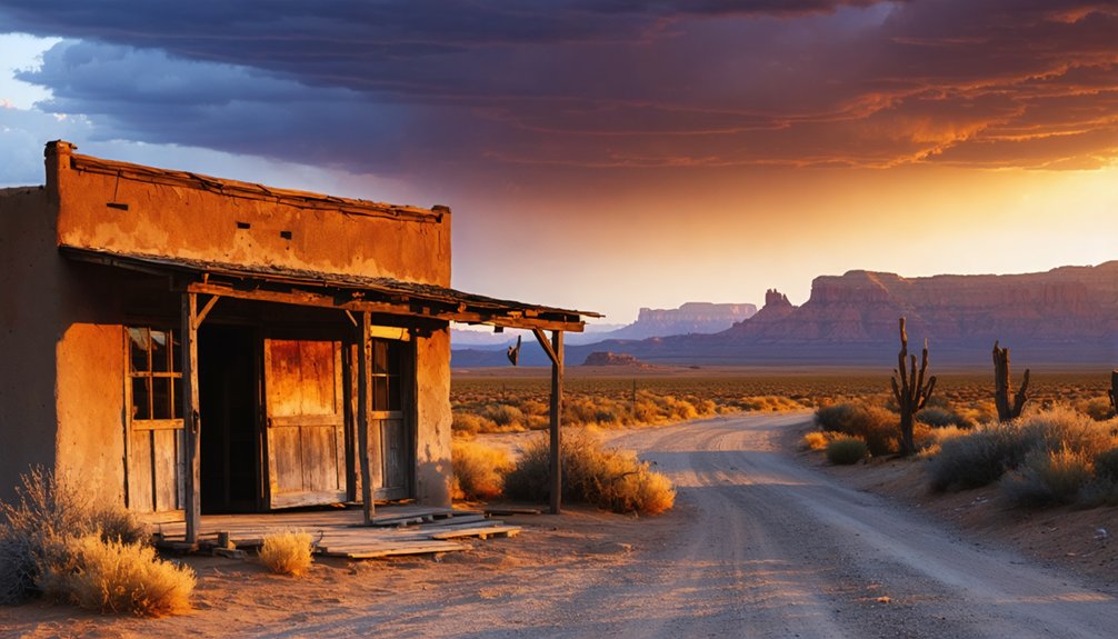
Today, Rockport sits submerged, one of America’s most compelling historical landmarks. When drought drops the reservoir low enough, foundations and roads resurface, turning ghost stories into tangible history you can witness firsthand.
Beneath the surface, history waits — rising with the drought to remind us the past never truly disappears.
It’s a rare opportunity to explore a town that traded its streets for silence — and occasionally rises again to tell its story.
Why the Town of Rockport Was Abandoned and Flooded
When the federal government announced plans for Wanship Dam in the early 1950s, Rockport’s fate was sealed. The abandonment reasons were straightforward but devastating: the government purchased the land around 1952, forcing roughly 27 families — nearly 200 residents — to surrender homes their ancestors had built since 1860.
By 1957, everyone had left. The dam rose, the reservoir filled, and an entire community disappeared beneath the water. The historical significance of this loss can’t be overstated — generations of sacrifice, a Black Hawk War survival story, and nearly a century of resilience simply vanished.
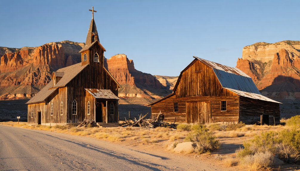
Before flooding, a few structures were saved. The Rockport Coop, School House, and chapel were relocated, preserving fragments of what the government’s decision erased forever.
Freedom, it turns out, has always carried a price.
Which Rockport Buildings Were Saved Before It Flooded
Before Rockport slipped beneath the reservoir’s surface, a handful of survivors escaped the flood. These saved structures carry profound historical significance, offering tangible connections to the town’s pioneer past.
Workers carefully relocated the Rockport Cooperative and the schoolhouse to Pioneer Village at Lagoon Amusement Park, where you can still walk through them today.
The old town chapel found new life at Rockport State Park’s campgrounds, standing as a quiet symbol of the community that once thrived here.
Sadly, most buildings weren’t preserved — they simply drowned alongside the town’s streets and foundations.
But these rescued structures remind you that history doesn’t have to vanish completely. Seek them out, touch their weathered walls, and let yourself feel the weight of what Rockport’s residents left behind.
How to Get to Rockport State Park
Reaching Rockport State Park is straightforward — the roads leading there are paved and accessible by standard 2WD vehicles, so you won’t need a rugged off-road setup to walk where Rockport’s pioneers once lived.
Located in Summit County, Utah, the park sits near Wanship, giving you access to scenic routes through Utah’s mountain terrain. You’re driving through the same landscape those 27 families once called home before the federal government purchased their land in the early 1950s.
Nestled in Summit County near Wanship, Rockport State Park winds through the same mountain terrain 27 families once called home.
Along the way, local attractions like the preserved chapel at the campgrounds connect you directly to that history.
Pack for the season — winters bring snow, summers run warm — and prepare for muddy conditions near the reservoir’s edge when drought exposes the submerged foundations below.
Best Time to Visit the Rockport Ghost Town
Once you’ve sorted the logistics of getting there, timing your visit determines what Rockport actually shows you. For best visiting conditions, aim for drought periods when reservoir levels drop considerably, exposing foundations, walls, and ghostly road remnants beneath the waterline.
The 2021 drought dropped water to 29% capacity, revealing structures submerged since 1957 for the first time in 64 years. Low water returned again by 2023.
Summer offers warm, accessible conditions, though the site’s historical significance resonates powerfully in quieter seasons too. November visits have yielded remarkable photographs of emerging ruins.
Whenever you go, wear boots you don’t mind muddying. The exposed foundations aren’t guaranteed, but when drought pulls that water back, Rockport stops being history and becomes something you can actually walk through.
What You Can Still See at Rockport’s Submerged Town?
When drought pulls the reservoir back, what emerges isn’t rubble—it’s a readable town.
You’ll trace foundation outlines where families once cooked meals and raised children. Roads reappear, cutting familiar paths through the lakebed. Stone walls still hold their shape after decades underwater.
These ghost town remnants carry real historical significance—each exposed structure represents one of the roughly 27 families displaced when the federal government flooded their world in 1957.
You can walk where a community stood for nearly a century.
Watch for thick mud along the exposed shoreline; it’ll slow you down if you’re not careful.
Bring good boots, a camera, and curiosity. What the water temporarily claims, it occasionally returns—and what it returns is worth seeing.
What to Bring and Know Before You Visit Rockport

Seeing those foundations and roads up close demands a little preparation. You’re stepping onto terrain that carries real historical significance — a town swallowed by federal decision-making, not time.
Pack your packing essentials: waterproof boots for muddy shorelines, layers for Summit County’s unpredictable temperatures, and a camera for capturing what drought reveals. Bring water, since you’re exploring open terrain without amenities nearby.
Check reservoir levels before heading out, because low water determines what’s actually visible. The boat ramp occasionally closes, but the park itself stays open.
Watch your footing near exposed foundations — the mud’s deceptive. Rangers and park historians can offer deeper context about Rockport’s settler roots and 1957 abandonment. You’re not just sightseeing; you’re witnessing a buried community reclaim its voice from the water.
Frequently Asked Questions
What Was Rockport’s Original Name Before It Became a Ghost Town?
Rockport’s original name was Crandall, later renamed Enoch City — its Original Settlement roots carry deep Historical Significance. You’re tracing a pioneer legacy that evolved through war, resilience, and ultimately, a submerged ghost town waiting to be rediscovered.
How Many Families Were Living in Rockport When It Was Abandoned?
When Rockport faced town abandonment in 1957, you’d have found approximately 27 families — nearly 200 resilient souls — calling it home. These family demographics paint a vivid picture of a tight-knit community surrendering their freedom to rising waters.
Did the Black Hawk War Play a Role in Rockport’s Early History?
Yes, you’ll find Black Hawk’s legacy woven deeply into Rockport’s story. The War’s impact forced settlers to flee north in 1866, and upon returning, they’d built a defining stone fort, shaping the town’s resilient identity forever.
How Does Rockport’s Story Compare to Lake Mead’s St. Thomas Ghost Town?
Like buried treasure rising from the deep, both ghost towns share hauntingly similar historical comparisons — drought exposes their submerged secrets. You’ll find Rockport’s foundations eerily mirror St. Thomas, as receding waters resurrect forgotten communities for you to explore.
Has the Submerged Ghost Town of Rockport Been Revealed More Than Once?
Yes, you’ve witnessed Rockport’s submerged history resurface more than once! Drought revealed its town legends in 2021, dropping the reservoir to 29% capacity, and low water levels exposed the ghostly foundations again by 2023.
References
- https://www.businessinsider.com/forgotten-town-utah-resurfaced-after-it-was-submerged-in-water-2021-9
- https://www.ksl.com/article/news/features/historic/utah-ghost-town-reappears-as-a-result-of-drought/50243431
- https://www.ghosttowns.com/states/ut/rockport.html
- https://www.deseret.com/utah/2023/3/11/23629503/lake-mead-water-level-utah-drought/


