San Carlos, California sits in Owens Valley, Inyo County, about three miles west of Bend City. Founded in 1863 during the gold rush, it was abandoned by 1866 when mining prospects collapsed. You’ll find low stone walls and melted adobe that’s been softening into the desert floor for over 160 years. Access is manageable via 2WD grid roads off major highways. There’s more to this forgotten place than first meets the eye.
Key Takeaways
- San Carlos, founded in 1863 during California’s gold rush, was abandoned by 1866 and sits in Owens Valley, Inyo County.
- The site is accessible via 2WD grid roads, located three miles west of Bend City, off major Inyo County highways.
- Visit in spring or summer, with early mornings ideal for cooler temperatures and optimal photography of the ruins.
- Pack water, sturdy footwear, sunscreen, a camera, and a paper map, as cell service in the area is unreliable.
- Nearby ghost towns, including Bend City, Cerro Gordo, and Ballarat, offer additional stops to enrich your road trip experience.
What Was San Carlos, California?
San Carlos was a brief flash of ambition in California’s Owens Valley, born in 1863 when gold fever swept east of the Sierra Nevada and drew settlers, cattle herds, and competing dreams of prosperity to the high desert.
Its historical significance stretched beyond mining prospects — it briefly contended for the Kosko County seat, suggesting real permanence.
But Indigenous conflicts, triggered by encroaching populations, destabilized the region, and when Kosko County dissolved into Inyo County in 1866, San Carlos lost its political footing entirely.
You’d find no residents there today, just faint stone and melted adobe ruins scattered across open terrain.
Among California’s ghost towns, San Carlos stands as a quiet reminder of how quickly ambition can vanish when the gold and the politics disappear simultaneously.
Where Exactly Is the San Carlos Ghost Town?
You’ll find San Carlos tucked into California’s Owens Valley, cradled between the Eastern Sierra and the high desert expanse of Inyo County.
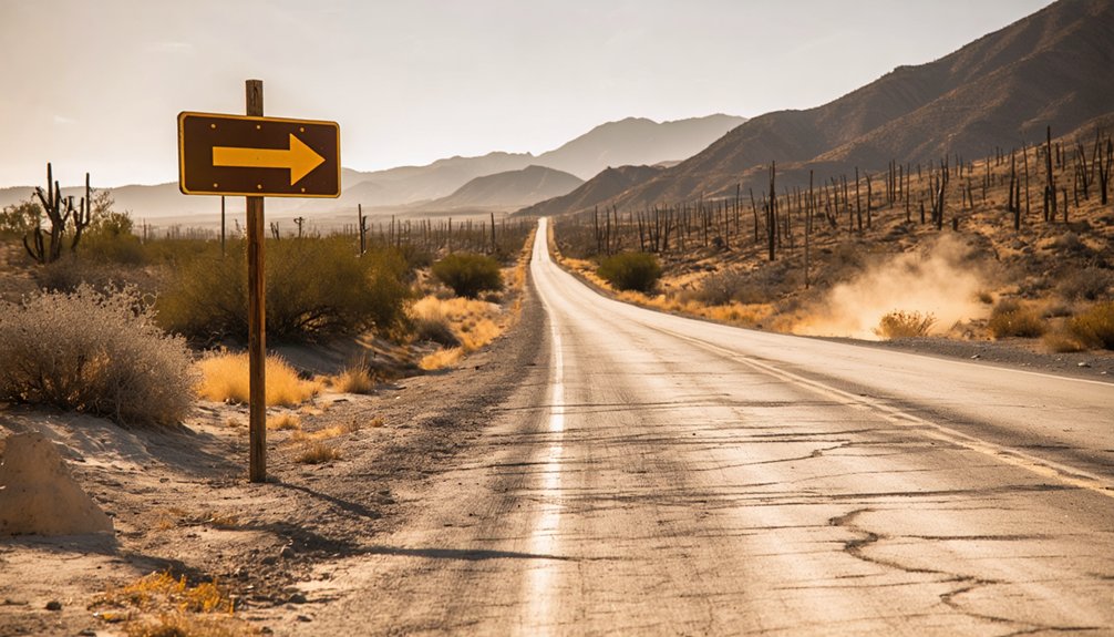
To reach the site, you’ll navigate 2WD-accessible grid roads branching off the major highways that cut through this stark, sun-bleached landscape.
Once there, you’ll need a sharp eye, since the scattered stone and melted adobe ruins blend quietly into the surrounding terrain as if the earth itself is slowly reclaiming what history left behind.
Owens Valley Eastern Sierra
Tucked within the vast Owens Valley, east of the rugged Sierra Nevada, the San Carlos ghost town sits quietly in Inyo County, California — a fragment of the Eastern Sierra’s gold rush past.
You’ll find it resting where ambition once burned bright and then faded just as quickly, leaving only stone and melted adobe behind.
The Eastern Sierra frames this landscape dramatically, its peaks looming over a valley that once buzzed with miners, cattle herds, and competing town founders.
The Owens Valley stretches wide and open around you, carrying a silence that feels almost earned.
Getting here is straightforward — 2WD roads connect the site to major highways — but you’ll want a sharp eye once you arrive.
The ruins don’t announce themselves.
Inyo County Exact Location
Three miles west of Bend City, the San Carlos ghost town anchors itself along the floor of the Owens Valley in Inyo County, California — a coordinate on the map that feels almost too quiet for the ambitions it once held.
You’ll find it tucked within the Eastern Sierra’s shadow, accessible via 2WD grid roads. Its California History runs deep here:
- Founded in 1863 during the gold rush era
- Once competed for Kosko County seat status
- Abandoned by 1866 after mining prospects collapsed
- Replaced administratively when Inyo County absorbed the region
That Ghost Town Significance hits differently when you’re standing among faint stone and melted adobe ruins.
No services. No crowds. Just open land carrying the memory of something that almost became something great.
Accessing The Site
Finding San Carlos demands a little intention — it won’t announce itself from the highway. You’ll reach it via 2WD grid roads branching off major routes through Inyo County, threading you into a landscape that still carries the quiet weight of ghost town history.
No signs celebrate the mining impact that briefly made this valley pulse with ambition. You’re maneuvering on instinct and preparation.
Pull up a reliable map before you leave. The roads are manageable, but the ruins themselves — scattered stone, melted adobe — blend stubbornly into the desert floor.
Summer offers the most forgiving conditions, with warmth softening the raw terrain. Arrive with sharp eyes and patience. San Carlos won’t meet you halfway, but that resistance is exactly what makes finding it feel earned.
The Best Time to Visit San Carlos Ghost Town
Most visitors find that the warm summer months offer the most rewarding conditions for exploring San Carlos ghost town. You’ll navigate the 2WD grid roads easily and spend more daylight hours uncovering the site’s historical significance among scattered adobe ruins.
Follow these best visiting tips before you go:
- Summer months deliver pleasant temperatures ideal for unhurried exploration.
- Spring offers mild conditions before intense desert heat arrives.
- Avoid winter — raw, unpredictable conditions make access challenging.
- Early mornings grant cooler temperatures and softer light perfect for photography.
You’re stepping into an 1863 gold rush memory, where silence replaced ambition almost overnight.
Come prepared, stay curious, and let the melted adobe walls tell their story on your terms.
How to Reach the San Carlos Ghost Town Site
To reach San Carlos, you’ll want to start by pulling up a detailed map of Inyo County and pinpointing the Eastern Sierra region east of the Sierra Nevada.
From there, you’ll navigate a network of 2WD grid roads branching off the major highways, so your standard vehicle will handle the terrain just fine.
Plan your drive during the warmer months, when the roads are dry and the ruins of stone and melted adobe emerge clearly from the valley floor, waiting like forgotten whispers from 1863.
Starting Your Route Planning
Reaching San Carlos ghost town takes just a few key decisions before you ever leave the pavement.
You’ll want to map your approach through Inyo County’s Eastern Sierra region, where route highlights include dramatic valley views and stark desert terrain carrying deep historical significance.
Before you roll out, lock in these essentials:
- Access point: Use major highways connecting to 2WD-friendly grid roads
- Season: Target warm summer months for reliable road conditions
- Navigation: Download offline maps since cell service gets sparse fast
- Supplies: Pack water, food, and fuel — there’s nothing commercial out there
You’re chasing remnants of 1863, when San Carlos briefly rivaled neighboring towns for county seat status.
Plan lean, drive deliberate, and let the open road deliver you straight into California’s forgotten past.
Once you leave the pavement, two things take over: the grid roads and your instincts. These unpaved corridors stretch across Inyo County in quiet, deliberate lines, connecting forgotten places that maps barely acknowledge.
For grid road navigation, you don’t need a high-clearance vehicle — 2WD handles the terrain well — but you do need attention. Distances feel deceptive out here, and landmarks blur into sagebrush.
Your ghost town exploration begins before you ever step out of the car. Watch the landscape shift. The Eastern Sierra rises hard to the west, and the valley floor flattens toward something older, quieter.
San Carlos won’t announce itself. You’ll earn it — scanning the scrub for faint stone outlines, melted adobe shapes, remnants of a world that moved on without saying goodbye.
Best Access Conditions
Timing matters when you’re heading to San Carlos. The Eastern Sierra’s raw winters can turn grid roads into muddy traps, burying the site’s geological features under unforgiving conditions.
Summer offers your best shot at reaching this forgotten corner of California history.
Plan your visit around these conditions:
- Season: Late spring through early fall delivers dry, navigable roads
- Temperature: Warm days keep the terrain firm and the ruins accessible
- Daylight: Longer summer days give you time to study the historical significance of scattered adobe remnants
- Vehicle: Standard 2WD handles the grid roads comfortably in dry conditions
You’re chasing echoes of 1863 out here. Don’t let poor timing steal that experience before you’ve even stepped foot on the ground.
What the San Carlos Ghost Town Ruins Actually Look Like
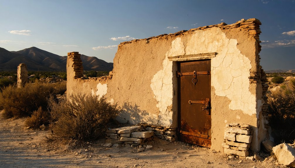
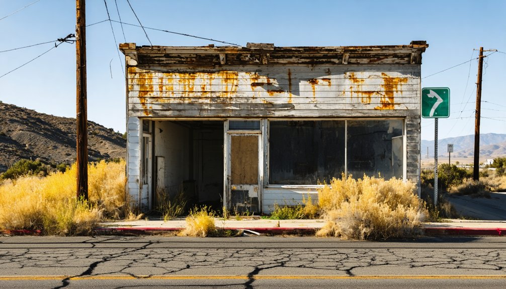
The ruins at San Carlos don’t announce themselves — you’ll scan the landscape before the fragments finally resolve into something recognizable. What remains are low stone walls and melted adobe, softened by 160 years of desert weather into organic, almost geological shapes. The adobe has literally dissolved downward, pooling at foundations like wax. Stone fragments scatter unpredictably across the scrub.
For ruin photography, the late afternoon light rewards patience, casting shadows that restore dimension to nearly flat walls. You won’t find historical artifacts lying exposed — those disappeared long ago — but the structural bones still communicate something honest about impermanence.
These aren’t dramatic Hollywood ruins. They’re modest, quiet, and somehow more affecting for it. Crouch low, look carefully, and let the site speak on its own terms.
Bend City, Chrysopolis, and Other Ghost Towns Near San Carlos
San Carlos didn’t rise alone — just three miles east, Bend City staked its own claim along the Owens River banks, and Chrysopolis emerged that same restless year of 1863.
All three towns briefly convincing themselves they’d outlast the desert. Indigenous conflicts scarred all three settlements equally, and none survived long enough to matter politically.
When you’re road-tripping this stretch, consider expanding your ghost town comparisons beyond San Carlos:
- Bend City — three miles east, same mining legacy, same quiet erasure
- Chrysopolis — founded simultaneously, significance fading faster than its name suggests
- Cerro Gordo — richer preservation efforts, darker local myths
- Ballarat — rawer visitor experiences, deeper Mojave isolation
Each site whispers a different version of the same broken promise.
What to Bring to the San Carlos Ghost Town Site
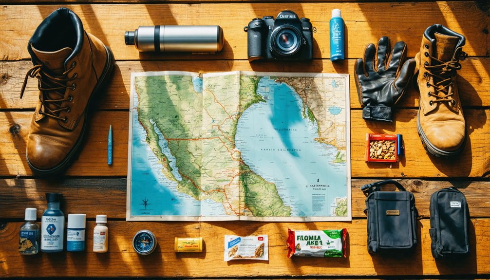
Visiting a site with no commercial services, no shade structures, and ruins that demand a sharp eye means you’ll want to pack deliberately.
Bring more water than you think you’ll need — the Eastern Sierra sun is unforgiving during summer visits. Sturdy footwear protects you across uneven terrain where melted adobe and stone fragments hide beneath scrub.
Carry a camera to document the historical significance of faint structural remains that won’t stand forever. Binoculars serve double duty, helping you spot distant ruins and observe local wildlife moving through the open valley.
Pack sunscreen, a wide-brimmed hat, and a paper map — cell service here is unreliable.
Most importantly, bring patience. San Carlos rewards the curious traveler who moves slowly, looks carefully, and lets the silence speak.
How to Explore the San Carlos Site Safely
Exploring San Carlos safely starts with a single rule: don’t rush. These ruins reward patience, not haste. Scattered stone and melted adobe hide easily underfoot, and the high desert heat demands respect.
Follow these exploration tips to stay safe while soaking in every ghostly detail:
- Watch your step — crumbling adobe blends seamlessly into the dusty ground
- Carry extra water — summer heat in the Eastern Sierra hits hard and fast
- Tell someone your plans — cell service is unreliable along these remote grid roads
- Wear sturdy footwear — uneven terrain and sharp stone fragments demand ankle support
Smart safety precautions let you move freely through San Carlos’s haunted silence without cutting your adventure short. Respect the land, and it’ll give you everything.
Frequently Asked Questions
Can I Camp Overnight at the San Carlos Ghost Town Site?
The knowledge doesn’t confirm camping regulations or overnight accommodations at San Carlos. You’ll want to check with Inyo County authorities before you unroll your bedroll beneath those star-filled skies among the ghostly adobe ruins.
Are There Any Guided Tours Available for San Carlos Ghost Town?
No guided tours exist, yet that’s the beauty — you’ll chart your own path through ghost town history. Embrace the freedom of self-guided exploration, where crumbling adobe whispers forgotten stories only your curious eyes can truly uncover.
Is the San Carlos Site on Public or Private Land?
The knowledge doesn’t confirm San Carlos’s land ownership, but you’re free to explore its historical significance independently. Those faint adobe ruins whisper of a forgotten era, inviting your adventurous spirit to wander and discover California’s raw, untamed ghost town heritage.
Have Any Artifacts Been Recovered From the San Carlos Ruins?
The knowledge base doesn’t spill the beans on recovered artifacts, but you’d uncover rich artifact significance and historical context exploring San Carlos’s faint stone and melted adobe ruins yourself — history’s waiting for your free-spirited discovery.
Are Pets Allowed When Visiting the San Carlos Ghost Town?
The knowledge doesn’t specify pet friendly policies for San Carlos. When visiting, you’ll want to check local regulations beforehand. These visiting tips guarantee you and your companions explore those hauntingly beautiful, freedom-calling ruins responsibly and memorably.
References
- https://www.barbaranusselphotography.com/blog/2017/4/20/wildflowers-and-ghost-towns-a-road-trip-through-central-california
- https://www.ghosttowns.com/states/ca/sancarlos.html
- https://www.visitcalifornia.com/road-trips/ghost-towns/
- https://www.visitcalifornia.com/now/california-ghost-towns-road-trip/
- https://www.tripadvisor.com/Attractions-g659472-Activities-c47-t14-California_Desert_California.html
- https://www.youtube.com/watch?v=FEiWdlOSoiw
- https://www.visitcalifornia.com/kr/road-trips/goseuteu-taun/
- https://www.explore.com/1709921/how-to-visit-best-california-ghost-towns-in-one-trip/
- https://www.hertz.com/p/american-road-trip-planner/west-coast/ghost-towns-of-the-west
- https://myfamilytravels.com/explore-californias-forgotten-towns-with-these-eerie-road-adventures/


