Planning a ghost town road trip to Slick Lizard, Kentucky starts in Barbourville, just 2 miles away, where you’ll fuel up, stock supplies, and grab a hot meal before heading into Knox County’s back roads. GPS gets unreliable fast, so download the Fount, KY topo map offline. Fall’s your best window — cooler temps, stunning foliage, and drivable roads. Former cemeteries, creek trails, and railroad remnants all tell the story of a vanished coal camp worth chasing down. There’s much more to uncover ahead.
Key Takeaways
- Slick Lizard is a ghost town in Knox County, Kentucky, once a thriving coal mining hub now frozen in Appalachian history.
- Start your trip from Barbourville, just 2 miles away, to stock up on supplies, fuel, and a hot meal before venturing out.
- GPS is unreliable near Slick Lizard; download the Fount, KY topo map offline before leaving Barbourville’s basecamp.
- Fall (September–October) is the best time to visit, offering cooler temperatures, stunning foliage, and ideal photography conditions.
- Nearby attractions include the Pennsy Store, Heidrick Railroad Station, and Daniel Boone’s Old Camp, all within 2.5 miles.
What Is Slick Lizard Coal Camp?
Tucked away in Knox County, Kentucky, Slick Lizard Coal Camp was once a bustling hub of coal mining activity that’s since faded into history.
This unincorporated community sits at roughly 1,033 feet elevation, quietly holding onto its coal history while the world moved on. You won’t find a thriving settlement here today — Slick Lizard now stands as a ghost town, a relic of an era when coal camps shaped entire communities across Appalachia.
Workers once lived, labored, and built lives within this tight-knit camp, making it far more than just a mining operation.
Today, it’s a compelling destination for anyone who craves open roads, forgotten places, and authentic American history waiting to be rediscovered on their own terms.
A Knox County Coal Town That Became a Ghost Town
Knox County, Kentucky has a way of holding onto its past, and Slick Lizard Coal Camp is proof of that. This unincorporated community once thrived on coal mining, drawing workers and families into its tight-knit settlement.
When the coal dried up, so did the life that sustained it. Today, it sits among Kentucky’s ghost towns — abandoned, quiet, and completely free from the noise of modern development.
When the coal ran out, so did everything else. What remains is silence, stillness, and land that time forgot.
You won’t find crowds here. What you’ll find is raw history, untouched landscape, and the kind of solitude that lets you think clearly.
The old camp’s story isn’t unusual for Appalachian Kentucky, but standing on that ground makes it feel personal. It’s a reminder that boom towns don’t last forever — and that’s exactly what makes them worth visiting.
How to Get to Slick Lizard, Kentucky
Getting to Slick Lizard means committing to the kind of back-road Kentucky that GPS doesn’t always handle well. Start in Barbourville, just 2 miles out, and stock up on supplies before heading into terrain that rewards the prepared traveler.
The Fount, KY US Topo quadrant is your most reliable navigation tool here — download it before you lose signal.
Accessibility challenges are real on these winding Knox County roads, so check weather conditions through the BARBOURVI station beforehand. Elevation shifts near 1,033 feet can make routes unpredictable after rain.
The historical significance of this former coal camp makes the effort worthwhile. You’ll pass railroad stations and century-old landmarks en route, each one pulling you deeper into a landscape that most travelers never bother to find.
What’s Left of the Coal Camp Today
What remains of Slick Lizard Coal Camp today is less a town than a ghost impression pressed into the landscape. You won’t find standing structures or marked streets — the coal mining heritage here survives in subtler ways.
Walk the terrain and you’ll notice the flattened ground where camp buildings once stood, the old hollow where miners lived and worked beneath Knox County’s ridge lines.
The ground here is flat where it shouldn’t be — buildings once stood, then didn’t.
The ghost town history lives in two nearby cemeteries — Warren and Fisher — both within walking distance and quietly holding the names of those who called this coal camp home.
Trace Branch still runs nearby, indifferent to the decades. Slick Lizard didn’t survive, but the land remembers. You’re free to read those traces however you choose.
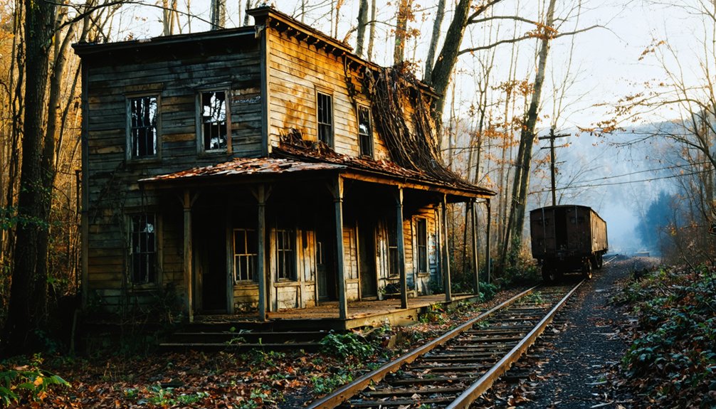
The Railroad Stops You’ll Pass on the Way In

Heading toward Slick Lizard, you’ll pass two railroad stations that hint at the industrial past that once made this corner of Knox County hum.
Just 1.5 miles out, the Heidrick Railroad Station stands as a quiet monument to railroad history that once moved coal out of these hills.
Push another tenth of a mile and you’ll reach Cannon Railroad Station, another relic of the coal mining network that connected remote camps like Slick Lizard to the wider world.
These stops weren’t just transit points — they were economic lifelines. Trains carried raw coal out and brought workers and supplies in.
Pulling over at both sites gives you real context before you reach the camp itself, grounding the ghost town experience in something tangible and powerful.
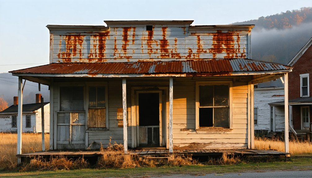
Pennsy Store, Logan Old Ford, and Daniel Boone’s Old Camp Nearby
Beyond the railroad stations, three more stops deserve a place on your itinerary.
Just 0.4 miles from Slick Lizard, the Pennsy Store historical site connects you directly to the coal camp era when company stores defined daily life for mining families. It’s a raw, honest glimpse into how workers lived and spent their wages.
Push a little further to Logan Old Ford, 2.3 miles out, where travelers once crossed water long before modern roads existed.
Then, at 2.4 miles, Daniel Boone’s Old Camp marks ground where one of America’s most celebrated frontier explorers actually rested. You’re not reading about history here — you’re standing inside it.
Few road trips offer this kind of layered, unfiltered access to America’s past.
Trace Branch, Tulley Branch, and the Creek Walks Around the Site
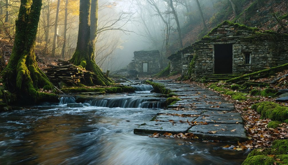
Just steps from the old coal camp, you’ll find Trace Branch at 0.3 miles and Tulley Branch at 0.4 miles, both offering natural walking paths that wind through the hollow.
These creek corridors give you a quiet, grounded way to explore the landscape that once supported the Slick Lizard Coal Camp‘s daily life.
As you walk the banks, watch for rocky shoals, overhanging hemlocks, and the kind of raw Appalachian terrain that makes these creek walks as memorable as the ghost town itself.
Trace Branch Walking Paths
Two creeks frame the ghost town site at Slick Lizard, giving road trippers a natural trail system that’s as rewarding as the ruins themselves.
Trace Branch runs just 0.3 miles from the coal camp, making it your closest entry point for walking paths along the water. Follow the creek bed and you’ll find terrain that’s raw, quiet, and entirely off the tourist radar.
Tulley Branch joins the picture at 0.4 miles out, adding another corridor worth exploring on foot. Together, these waterways carve through the Kentucky hills and give you a sense of how miners once moved through this landscape daily.
Lace up sturdy boots, pack light, and let the creek systems guide your exploration of this forgotten corner of Knox County.
Tulley Branch Water Features
Tulley Branch sits a stone’s throw from the old coal camp, and once you’ve walked the Trace Branch corridor, it pulls you naturally to the next creek over.
At just 0.4 miles from Slick Lizard, you’ll reach Tulley Branch without breaking much of a sweat.
The tulley branch history connects directly to the coal camp era, when miners and their families relied on these waterways for daily life.
Today, the creek runs quieter, and tulley branch wildlife thrives where industry once dominated.
Watch for herons picking through shallow riffles, box turtles sunning on mossy banks, and deer trails cutting down to the water’s edge.
These two creeks together give you a genuine backcountry feel without straying far from the ghost town’s core.
Creek Walk Exploration Tips
Walking the creek corridors around Slick Lizard rewards you with some of the most accessible backcountry exploration in Knox County.
Trace Branch runs just 0.3 miles from the old coal camp, while Tulley Branch sits 0.4 miles out, giving you two distinct creek walks within easy striking distance.
Move slowly along the banks and you’ll maximize your wildlife spotting opportunities — herons, turtles, and river otters frequent these hollows.
Creek safety matters here, so wear grippy footwear, watch for slippery limestone ledges, and never cross moving water above knee depth after rainfall.
The narrow creek corridors also funnel your view toward the surrounding ridgelines, connecting you visually to the same landscape that Slick Lizard’s coal miners once navigated daily.
Bring trekking poles for stability.
Where to Stock Up in Barbourville Before You Hit the Trail

Before heading out to Slick Lizard, you’ll want to make a quick stop in Barbourville, just two miles away, where you can grab groceries and fuel up for the trail.
A handful of local diners line the main strip, giving you a hot meal and a strong cup of coffee before you tackle the back roads.
Stock your pack with water, snacks, and any gear you’re missing, because once you leave town, you’re on your own.
Local Grocery Store Options
Stocking up in Barbourville — just 2 miles from Slick Lizard — is your smartest move before heading into Knox County’s backcountry. You won’t find convenience stores near an abandoned coal camp, so plan ahead.
Barbourville’s grocery store options give you everything you’ll need: water, snacks, camp fuel, and road food that won’t weigh you down.
Hit the local markets early, especially if you’re rolling out at dawn. Smaller local shops often carry regional staples you won’t find at chain stores — think locally made jerky, fresh cornbread, and regional hot sauces worth tossing in your pack.
You’re exploring ghost town territory, so treat your supply run seriously. A well-stocked cooler means fewer interruptions and more time wandering Slick Lizard’s forgotten history on your own terms.
Fuel And Supply Stops
Barbourville sits just 2 miles from Slick Lizard, making it your last real chance to fuel up before the pavement gives way to backcountry Knox County roads.
Prioritize fuel efficiency by topping off your tank here — mountain terrain burns more than you’d expect.
Stock up on these supply essentials before heading out:
- Fuel – Fill your tank completely; no stations exist near the ghost town
- Water – Carry more than you think you’ll need for the trail
- Snacks and food – Grab enough for a full day of exploration
- Navigation tools – Download the Fount, KY topo map offline
Don’t assume you can double back easily. Barbourville is your basecamp — use it wisely.
Dining Before Departing
A solid meal and a stocked pack can make or break a ghost town run, so take full advantage of Barbourville’s dining scene before you leave civilization behind.
Sitting just two miles from Slick Lizard, this small Kentucky town punches above its weight with genuine local cuisine that’ll fuel your exploration.
You’ll find dining options ranging from hearty Southern comfort food to quick grab-and-go spots perfect for loading up before hitting the trail.
Grab a hot breakfast, fill your thermos, and pack extra snacks because once you’re moving through Knox County’s back roads toward that old coal camp, convenience disappears fast.
Eat well, eat local, and treat the meal as part of the adventure itself.
The Best Time of Year to Visit Slick Lizard
When you’re planning a ghost town road trip to Slick Lizard, Kentucky, timing can make or break the experience. Weather considerations are critical since this elevated coal camp sits near 1,033 feet. Choosing the best season guarantees safer roads and better exploration conditions.
Here’s when to go:
- Spring (April–May) – Mild temperatures, blooming surroundings, and accessible trails make exploration rewarding.
- Summer (June–August) – Long daylight hours maximize exploration time, though humidity can be heavy.
- Fall (September–October) – Cooler temps and stunning foliage create dramatic, atmospheric conditions perfect for ghost town photography.
- Winter (November–March) – Avoid if possible; icy mountain roads near Barbourville create dangerous driving conditions.
Fall remains the undisputed champion for visiting Slick Lizard’s haunting landscape.
Day Trip or Overnight: How Long You Need to See It All
Once you’ve picked your season, the next decision is figuring out how much time Slick Lizard actually deserves on your itinerary.
For most travelers, a half-day covers the ghost town exploration itself, leaving time to hit nearby landmarks like the Pennsy Store and Heidrick Railroad Station.
A half-day handles the ghost town, with time left for the Pennsy Store and Heidrick Railroad Station.
If historical significance drives your curiosity, a full day lets you absorb Daniel Boone’s Old Camp and Logan Old Ford without rushing.
Barbourville sits just two miles away, offering food, fuel, and lodging if you’d rather stretch things into an overnight stay.
That extra time opens the door to nearby cemeteries, branch trails, and railroad ruins that a quick visit misses entirely.
You’ve got the freedom — use it wisely and plan the experience you actually want.
Frequently Asked Questions
Are There Any Entry Fees or Permits Required to Visit Slick Lizard?
You don’t need entry fees or permit requirements to visit Slick Lizard! It’s an unincorporated community, so you’re free to explore this fascinating ghost town and soak up its rich coal mining history.
Is Slick Lizard Accessible by Wheelchair or Mobility-Assisted Devices?
Coincidentally, Slick Lizard’s rugged, uneven terrain makes wheelchair accessibility and mobility assistance challenging. You’ll find unpaved paths and natural landscapes that don’t accommodate devices easily, so plan accordingly and bring supportive companions for your adventurous ghost town exploration.
Can You Legally Metal Detect or Artifact Hunt at the Coal Camp?
You’ll need to research local metal detecting regulations before hunting at Slick Lizard’s coal camp. Always respect artifact preservation ethics, get landowner permission, and follow Kentucky state laws to guarantee you’re legally and responsibly exploring this historic site.
Are There Any Guided Tours Available Specifically for Slick Lizard?
You won’t find guided tours specifically for Slick Lizard, but you can explore its rich local history independently. Nearby Barbourville offers guided experiences that’ll deepen your understanding of the region’s coal mining heritage.
Is Cell Phone Service Reliable Near the Slick Lizard Site?
Cell service near Slick Lizard is practically nonexistent! You’ll likely face serious connectivity issues in this remote Kentucky hollow, so download your maps offline before you go and embrace the freedom of being completely off-grid.
References
- https://en.wikipedia.org/wiki/Slick_Lizard_Coal_Camp
- https://www.anyplaceamerica.com/directory/ky/knox-county-21121/locales/slick-lizard-coal-camp-historical–2543344/
- https://www.youtube.com/watch?v=cmkLLK5o4-U
- https://www.onlyinyourstate.com/nature/colorado/top-secret-nature-spot-co-2
- https://www.towindustryweek.com/13-tow-illustrated/7697-lizard-lickin-good