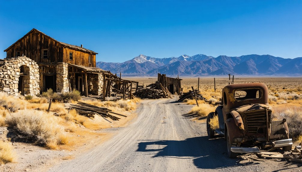
Beveridge Ghost Town sits deep in Inyo County’s Beveridge Canyon at 5,587 feet, and you won’t reach it by car. You’ll launch from Panamint Springs Resort, tackle a grueling 20-mile round trip with nearly 9,000 feet of elevation gain, and emerge at a site where $500,000 in gold once changed everything. It’s remote, legally protected, and completely untouched by tourism. Everything you need to plan your journey and know what awaits you is covered ahead.
Key Takeaways
- Beveridge Ghost Town sits at 5,587 feet in Inyo County, California, near Panamint Springs Resort, which serves as your last basecamp with fuel and cabins.
- Plan your visit between mid-March and May or mid-September and November to avoid dangerous summer heat exceeding 110°F.
- The demanding 20-mile round-trip hike gains nearly 9,000 feet of elevation, requiring an early 5–6am alpine start from Panamint Springs.
- Pack at least three liters of water, topographic maps, a satellite communicator, and calorie-dense foods like jerky, nuts, and energy bars.
- Federal law prohibits removing artifacts or disturbing structures at Beveridge, ensuring the site’s authentic, untouched historical character remains preserved.
Where Is Beveridge Ghost Town and How Do You Get There?
Tucked into the eastern slope of the Inyo Mountains within Beveridge Canyon, this remote ghost town sits at an elevation of 5,587 feet in unincorporated Inyo County, California.
Its Beveridge history and mining significance trace back to 1877, when William Lyle Hunter discovered gold here, extracting roughly $500,000 worth before operations ceased.
To reach it, you’ll start near Panamint Springs Resort, aiming for a 5–6am alpine start. From Saline Valley, you’ll climb from 1,000 feet to 7,000 feet, then descend to around 3,000 feet — nearly 9,000 feet of elevation gain across a grueling 20-mile round trip.
Trails from 1975 maps have washed out, so expect serious bushwhacking. This isn’t a casual detour; it’s a demanding journey rewarding only the most self-reliant explorers.
The Best and Worst Months to Hike Into Beveridge Canyon
Spring (April–May) and fall (September–October) give you the most forgiving conditions for the brutal 20-mile round trip into Beveridge Canyon, when desert heat stays below triple digits and high-elevation snow has either melted or hasn’t yet arrived.
You’ll want to avoid summer at nearly all costs—temperatures on the Saline Valley floor routinely exceed 110°F, turning the 1,000-to-7,000-foot ascent into a genuine survival scenario.
Winter closes the high passes with snow and ice, making an already-unforgiving trail potentially impassable without technical gear.
Ideal Hiking Season Windows
Because Beveridge Canyon climbs from a scorching desert floor to elevations above 6,000 feet, the hiking season here is narrower than most California ghost town routes.
Timing your visit protects both your safety and your experience.
Your best windows are:
- Mid-March through May — Moderate desert temps, manageable snowmelt, and wildflowers marking the old miners’ trails.
- Mid-September through November — Cooling canyon air, reduced rattlesnake activity, and clearer skies after summer monsoons.
- Full moons in shoulder seasons — Extended navigable hours reward those craving genuine freedom from crowded trails.
Summer bakes the lower canyon past survivable limits.
Winter buries the upper route in snow.
Wildlife encounters peak in spring, demanding extra hiking safety awareness.
Plan accordingly, and Beveridge rewards you.
Months To Avoid
Summer and winter don’t just inconvenience you on the trail to Beveridge — they can kill you.
June through August bakes the desert floor near Saline Valley past 110°F, turning your 9,000-foot elevation climb into a dangerous gamble against heat exhaustion before you’ve even entered the canyon. Weather patterns shift brutally fast at elevation, offering zero shelter on exposed ridgelines.
December through February buries the upper trail in snow and ice, making that same ridgeline treacherous without technical gear.
Miners who worked this site understood these seasonal rhythms — historical significance aside, they abandoned operations during brutal weather windows, not out of weakness, but survival wisdom.
Respect that same logic. Your freedom to explore this remote canyon depends entirely on choosing the right months.
Panamint Springs and Lone Pine: Your Last Stops Before Beveridge
Before you commit to the brutal push into Beveridge Canyon, two outposts demand your attention: Panamint Springs Resort, your ideal staging ground for that critical 5-6am alpine start, and Lone Pine, sitting just 11 miles southwest on Route 395.
Stock up in Lone Pine on water, food, and emergency supplies, because once you leave its streets behind, you’re trading civilization for a 20-mile round trip with 9,000 feet of elevation change and no safety net.
Panamint Springs gives you a closer launching point near Death Valley’s border, so use it wisely—your legs will thank you when you’re not burning energy on extra pre-dawn miles before the real climb even begins.
Panamint Springs Resort Overview
Nestled along Highway 190 at the edge of Death Valley National Park, Panamint Springs Resort serves as your last real basecamp before committing to Beveridge’s brutal approach. This remote outpost carries genuine Panamint Springs history, operating since the 1930s amid raw desert isolation.
Its Panamint Springs amenities give you exactly what a serious desert traveler needs:
- Fuel your vehicle before tackling unpaved roads toward Saline Valley
- Secure a cabin or campsite for your pre-dawn alpine start
- Stock up on water and food at the on-site restaurant and store
You’ll want that 5-6am departure locked in before leaving here. The desert doesn’t negotiate, and Beveridge’s 9,000-foot elevation gain punishes anyone who underestimates the approach.
Lone Pine Proximity Benefits
Eleven miles southwest of Beveridge along Route 395, Lone Pine anchors your final urban foothold before the Inyo Mountains swallow the trail.
Stock up on Lone Pine amenities — fuel, water, food, and emergency supplies — before the landscape strips away every convenience you’ve taken for granted.
The Alabama Hills frame the town’s western edge, delivering scenic views of jagged Sierra peaks that remind you exactly what kind of terrain you’re walking into.
Hardware stores, gas stations, and a handful of diners give you one last chance to patch gaps in your gear list.
Don’t waste it. Beveridge doesn’t offer second chances, and the desert separating you from that canyon rewards preparation ruthlessly.
Lone Pine isn’t just a waypoint — it’s your final negotiation with civilization.
Essential Pre-Hike Supplies
Two stops define your logistics before Beveridge claims you: Panamint Springs Resort and Lone Pine. Both settlements anchor your hydration strategies and trail safety preparations before the canyon swallows you whole.
Stock up deliberately:
- Water and electrolytes — you’ll climb from 1,000 feet to 7,000 feet; dehydration accelerates dangerously in desert heat.
- Topographic maps — pre-1975 trails have washed out entirely, demanding navigation tools beyond a smartphone signal.
- Emergency supplies — first aid, emergency bivouac gear, and a satellite communicator, because helicopter rescues here have nearly turned fatal.
Leave Panamint Springs by 5:00 or 6:00 a.m. The alpine start isn’t optional — it’s survival arithmetic.
Lone Pine offers your final resupply window, eleven miles southwest on Route 395, before wilderness replaces convenience entirely.
What to Pack for a 20-Mile Desert-to-Mountain Hike With No Resupply
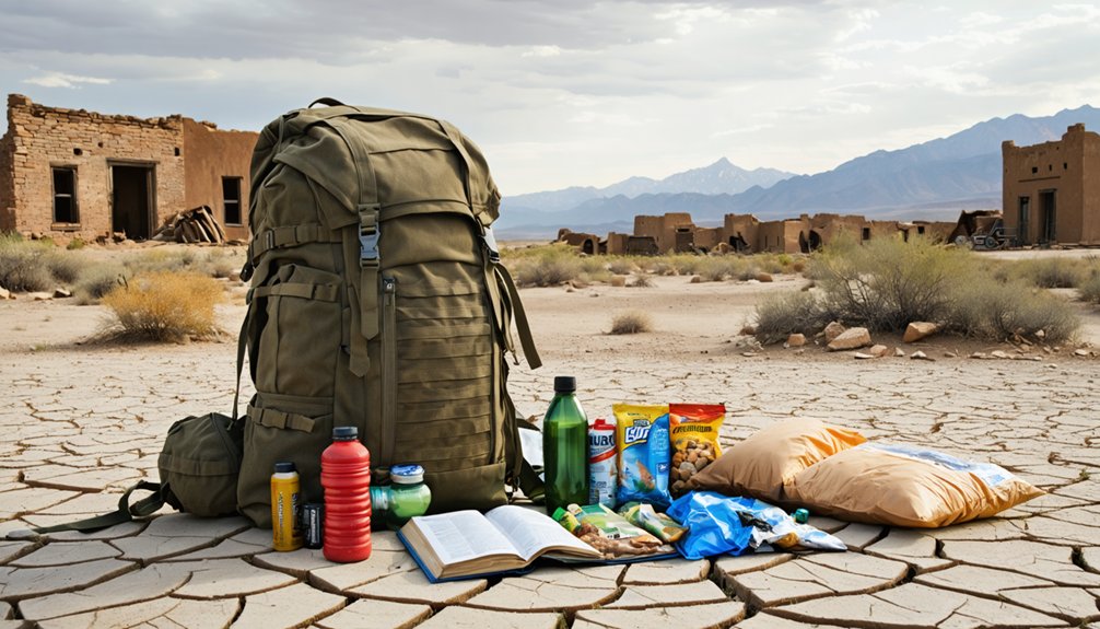
What you carry into Beveridge’s canyon could mean the difference between a grueling adventure and a genuine emergency. This 20-mile round trip demands serious hiking gear — trekking poles, layered clothing for dramatic weather considerations, and broken-in boots for 9,000 feet of elevation gain.
Water sources are scarce, so carry three liters minimum. Navigation tips matter here: pre-download onXmaps because cell service vanishes. Pack a first aid kit that handles blisters, sprains, and desert survival scenarios.
Food options should prioritize calorie-dense, lightweight choices — jerky, nuts, energy bars.
Wildlife encounters with rattlesnakes and bighorn sheep are real possibilities, so stay alert. Save weight by selecting dual-purpose photography spots along the trail.
Trail safety means leaving a detailed itinerary with someone reliable before you disappear into this forgotten canyon.
The Brutal Hike Into Beveridge Canyon: What to Expect
Few hikes in California’s desert interior demand as much raw commitment as the climb into Beveridge Canyon — a route that strips away any romantic notion of ghost town exploration within the first mile.
Approaching from Saline Valley, you’ll climb 6,000 feet before descending sharply into a canyon sheltering remnants of an 1880s gold rush. Beveridge history rewards only those who earn it.
Six thousand feet of relentless climbing separates the curious from those who truly deserve Beveridge’s secrets.
Expect these realities before you commit:
- Elevation swings from 1,000 to 7,000 feet, then back to 3,000 feet
- Pre-1975 trails are washed out, demanding constant bushwhacking
- A 5–6am alpine start is non-negotiable for safety
Essential hiking tips: carry redundant navigation tools and never underestimate desert heat at lower elevations.
What You’ll Actually Find When You Reach Beveridge
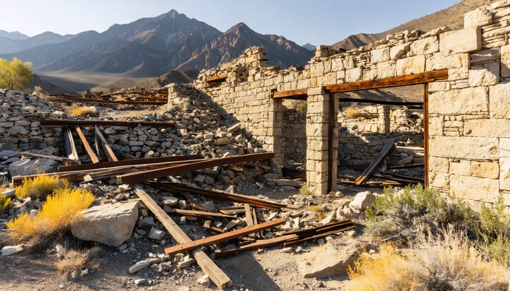
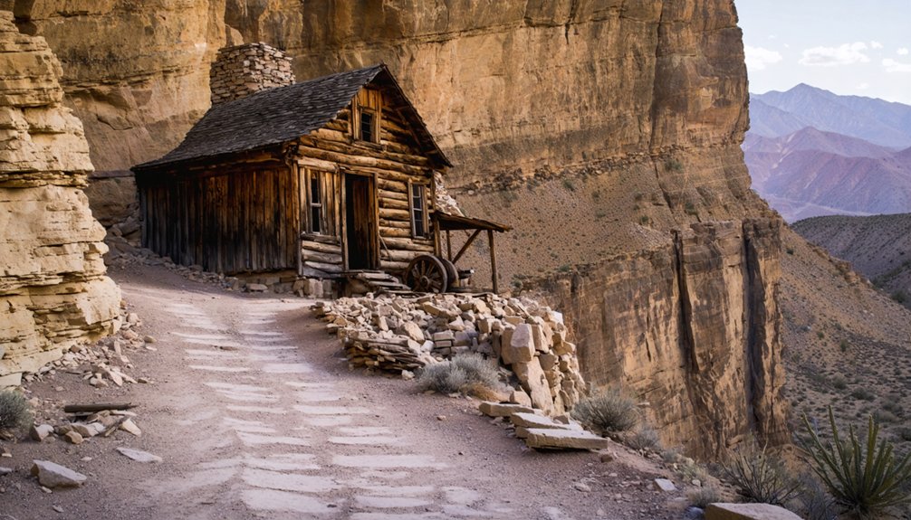
After earning every foot of elevation, you’ll arrive at a canyon settlement frozen somewhere between ruin and memory — rock shelters with walls but no roofs, cabins reduced to timber and stone, and mining equipment slowly surrendering to the Inyo Mountains climate.
Walls extend naturally from overhanging rock faces, revealing how miners used the canyon itself as a building partner. A yellow BLM sign references the Antiquities Act, reminding you that Beveridge history carries legal protection.
Artifacts are scarce — reportedly looted by helicopter in earlier decades — so don’t expect a treasure hunt. What remains is the mining legacy itself: the geography, the silence, and the faint structural bones of a community that pulled $500,000 in gold from this remote canyon before disappearing entirely.
Why You Can Look but Not Touch Anything at Beveridge
That yellow BLM sign isn’t just a formality — it’s the clearest signal that Beveridge operates under a specific legal framework that governs everything you can do once you arrive. The Antiquities Act protects this site’s historical significance, meaning preservation practices aren’t optional.
You can explore freely, but the rules are firm:
- Don’t remove artifacts, equipment, or structural materials
- Don’t disturb rock-built structures, cabin remnants, or canyon walls
- Don’t deface or reposition anything the miners left behind
Helicopter looters already stripped much of what once made Beveridge extraordinary. What remains is irreplaceable.
Your freedom here means experiencing history exactly as it survived — untouched, raw, and honest. Respect that, and the site stays accessible for every adventurer who follows your footsteps.
How a Single Gold Strike in 1877 Built a Town No Road Could Reach
When William Lyle Hunter struck gold in November 1877, he didn’t just find ore — he triggered a chain of events that would carve a functioning town into one of California’s most hostile mountain flanks. That single discovery ignited a gold rush that drew miners, equipment, and ambition into Beveridge Canyon‘s rugged terrain.
Hunter eventually sold his claims to Mortimer Belshaw of Cerro Gordo fame, accelerating development fast. A five-stamp mill followed, and the Big Horn mine sparked what locals called the Beveridge Bonanza.
Isolation, Gold Rush Ruins, and Zero Crowds: Why Beveridge Delivers
Few ghost towns earn their reputation the way Beveridge does — not through accessibility or notoriety, but through the brutal arithmetic of getting there. You’ll gain 9,000 feet over 20 miles, earning every fragment of mining history you encounter. What waits rewards the effort:
- Rock shelters with walls extending from canyon overhangs, silent reminders of 1880s survival
- Scattered cabin remnants and mining equipment frozen mid-abandonment
- A BLM Antiquities Act sign marking ground that helicopter looters have already raided
Ghost town lore rarely delivers this honestly. No tour buses. No gift shops. Just $500,000 worth of extracted gold’s echo and structures that predate your great-grandparents.
Beveridge doesn’t perform history — it simply remains it, unchanged and uncompromising, waiting for travelers serious enough to arrive.
Frequently Asked Questions
Was Beveridge Ever Connected to Other California Gold Mining Towns?
By sheer coincidence of gold mining fate, you’ll find Beveridge’s historical connections run deep — William Hunter sold claims to Cerro Gordo’s Mortimer Belshaw, weaving this ghost town into California’s broader mining heritage tapestry.
How Much Gold Was Extracted From Beveridge in Today’s Dollars?
Beveridge’s gold extraction totaled $500,000 in late 1800s value—after inflation adjustment, that’s roughly $17–18 million today. You’re standing where miners clawed that fortune from unforgiving canyon rock with nothing but grit and ambition.
Who Was John Beveridge, and Why Was the Town Named After Him?
Like a name etched in canyon stone, John Beveridge’s legacy endures—he was an early Owens Valley resident whose Inyo Mountains discoveries shaped Beveridge history, earning him the honor of having this wild, forgotten gold town named after him.
What Happened During the Nearly Fatal Helicopter Access Attempt at Beveridge?
The details of the helicopter rescue aren’t fully documented, but you’d know the emergency response nearly ended in disaster. That harrowing attempt reminds you why Beveridge’s rugged isolation demands respect — it’s always guarded its secrets fiercely.
Is Beveridge Canyon Listed in Any Official Geological or Mineral Databases?
Yes, you’ll find Beveridge Canyon’s geological significance officially recognized — it’s listed as Beveridge Canyon Mn No. 12 in the USGS Mineral Resources Data System, confirming its documented mineral resources and enduring legacy in America’s wild, untamed frontier history.
References
- https://www.ghosttowns.com/states/ca/beveridge.html
- https://en.wikipedia.org/wiki/Beveridge
- https://theancientsouthwest.com/2016/06/08/the-great-white-wall/
- https://www.youtube.com/watch?v=iYCAwk5oxFE
- https://www.youtube.com/watch?v=NnRacV_p5Ig
- https://www.bricepollock.com/the-beverage-lesson-in-humility/
- https://www.onxmaps.com/hiking/d7861xmd7qlm/beveridge-ghost-town


