
Planning a ghost town road trip to Calcite, South Dakota means venturing deep into Black Hills backcountry via rugged dirt roads four miles west of Maitland, so you’ll need a high-clearance 4WD vehicle. Late spring through early fall offers the best conditions. Once there, you’ll find standing structures, an abandoned bus, and open mine shafts from an 1880s carbonate silver-lead rush. Keep exploring to uncover everything this remarkably intact ghost town still holds.
Key Takeaways
- Use GPS coordinates 44°24′00″N, 103°52′07″W and bring offline maps, as limited cell coverage makes navigation challenging near Calcite.
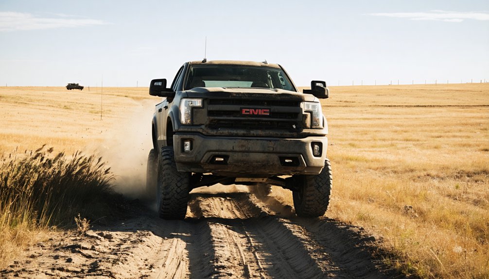
- A high-clearance 4WD vehicle is essential for accessing Calcite via degraded dirt roads four miles west of Maitland.
- Visit between late spring and early fall for optimal road conditions, longer daylight hours, and safer exploration opportunities.
- Stay away from open mine shafts and unstable structures, as unmarked hazards throughout the site pose serious safety risks.
- Extend your road trip by including nearby ghost towns like Rochford, Mystic, Deadwood, and Lead for a comprehensive historical experience.
Why Calcite Remains One of the Black Hills’ Most Intact Ghost Towns
When most ghost towns crumble into memory, Calcite stubbornly holds its ground.
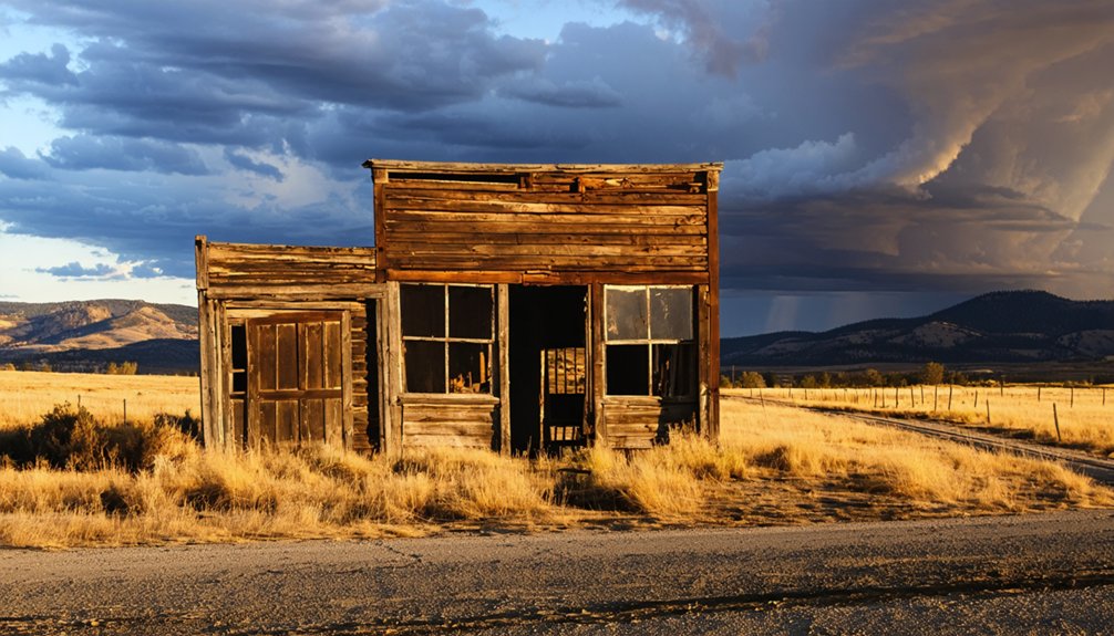
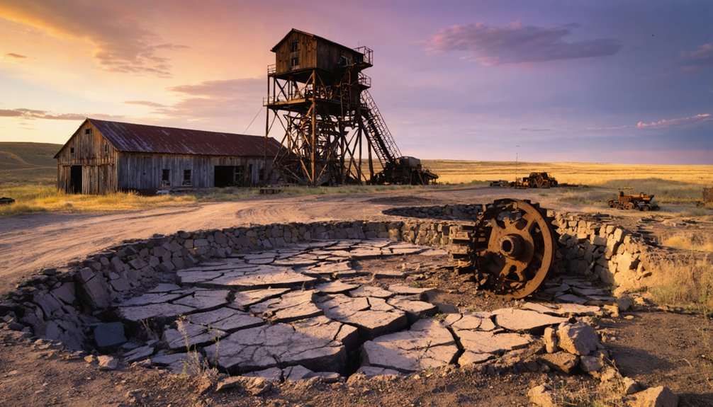
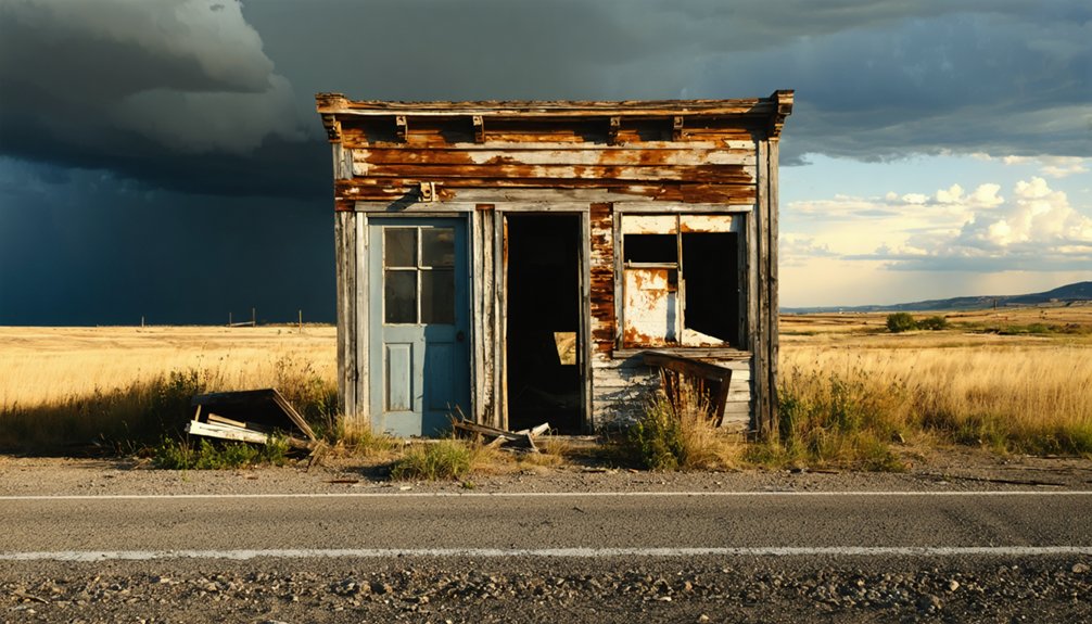
You’ll find a standing house, an abandoned bus, intact mining structures, and gaping shafts that hard rock mining techniques carved deep into the earth. The cemetery still watches over the hillside, and waste piles mark where miners once chased carbonate ore through the 1880s.
Calcite history explains this preservation well. Because no railroad ever reached this remote Lawrence County settlement, outside development never followed. Roads degraded early, tourism never arrived, and the town simply froze in place.
No railroad ever reached Calcite — and that absence alone is what kept it frozen in time.
Its isolation, once its economic downfall, became its greatest protector.
You’re not visiting a reconstructed attraction here. You’re walking through an authentic Black Hills mining camp that time largely forgot — and that makes every step worth taking.
How a Silver-Lead Strike Turned Calcite Into a Boomtown
When you trace Calcite’s origins, you find a single July 1881 newspaper article in the *Black Hills Daily Times* that ignited everything — a report on carbonate ore, a silver-lead mixture, that drew settlers hungry for fortune.
James Ridpath had already staked his claim around 1880, founding the West Virginia Mine and giving the camp its first identity, initially called Virginia or West Virginia after the settlers’ home state.
That one discovery set off a chain reaction, pulling miners and fortune-seekers into the Black Hills and transforming a remote hillside into a bustling carbonate camp almost overnight.
Carbonate Ore Discovery
Before the town had a name, it had a strike. When prospectors cracked open the hillside and pulled out carbonate ore — a dense silver-lead mixture — word spread fast. The Black Hills Daily Times ran the story in July 1881, and suddenly everyone wanted a claim.
Carbonate ore’s significance wasn’t just geological. Silver and lead together meant real money, and miners knew it. They drove shafts deep into the hard rock using hand-drilling and blasting techniques common to the era, carving tunnels that still gape open today.
James Ridpath had already staked the West Virginia Mine around 1880, setting the template. Others followed his lead, adopting the same hard-rock mining techniques to chase the same seams.
The rush was on, and the hills would never look the same.
Mining Settlement Growth
Once the Black Hills Daily Times published that July 1881 article, the carbonate strike at Calcite stopped being a quiet secret. Prospectors, laborers, and opportunists flooded in, transforming James Ridpath’s solitary West Virginia Mine claim into a full-blown boomtown culture almost overnight.
By 1886, multiple mines were operating simultaneously. The Iron Hill Mine broke ground in 1885, pulling gold and galena from the earth using hard rock mining techniques that defined the era.
The Seabury-Calkins Mine ran parallel tunnels nearby, the two operations intersecting underground during a fire — that accidental connection saved lives.
You’d have witnessed a community built entirely on extraction and ambition. Six additional local mines kept the momentum surging, making Calcite one of the Black Hills’ most productive and overlooked silver-lead camps.
Best Time of Year to Visit Calcite, South Dakota?
Timing your visit to Calcite, South Dakota, can make the difference between an adventurous exploration and a frustrating dead end.
Late spring through early fall offers the best conditions for traversing the degraded, off-beaten-path roads leading to this remote Black Hills ghost town. Summer’s longer daylight hours give you more time to explore the cemetery, remaining structures, and mine shafts while appreciating Calcite’s historical significance as a once-thriving carbonate ore camp.
Avoid winter entirely — snow and ice make high-clearance vehicle travel nearly impossible.
Fall brings stunning foliage and cooler temperatures, perfect for seasonal activities like photography and hiking between abandoned mining sites.
Whatever season you choose, always check road conditions before departing.
How to Find Calcite Using GPS Coordinates and Back Roads
Finding Calcite means leaving paved roads behind and trusting a mix of GPS precision and old-fashioned backcountry instinct. Punch these coordinates into your GPS Navigation app: 44°24′00″N, 103°52′07″W. You’ll approach from four miles west of Maitland through Black Hills back roads that reward patience.
Before you roll out, lock in these essentials:
- Vehicle requirements: High-clearance 4WD handles the degraded dirt roads confidently
- Scenic Routes: Black Hills offers breathtaking ridge lines and dense ponderosa pines en route
- Backup navigation: Download offline maps since cell coverage disappears fast out here
The roads mirror Calcite’s history — rough, unforgiving, and utterly worth it.
No railroads ever reached this camp, meaning every visitor earns the destination, just like the miners once did hauling ore by wagon toward Lead.
What Vehicle You Actually Need to Reach Calcite
Punching in those coordinates gets you pointed in the right direction, but your vehicle determines whether you actually make it.
Calcite sits four miles west of Maitland along roads that haven’t improved much since ore wagons churned through them. Road conditions out here range from rutted dirt tracks to washed-out switchbacks cutting through Black Hills terrain.
You’ll need a high-clearance vehicle — think truck or capable SUV — not a sedan or low-riding crossover. Four-wheel drive gives you an extra safety margin when slopes turn loose or wet.
Check conditions before heading out since seasonal weather can transform passable trails into muddy traps overnight. The right vehicle types open up this forgotten corner of Lawrence County; the wrong one leaves you stranded miles from anywhere.
What’s Still Standing in Calcite Today?
Once you pull into Calcite, the remnants scattered across the site tell a story that official histories often skip. Abandoned structures still interrupt the tree line, and cemetery exploration reveals weathered markers from miners who never left.
Here’s what you’ll actually find:
- The cemetery, where headstones stand unevenly among overgrowth, marking those who lived through the boom and bust
- A lone house and abandoned bus, frozen in time, offering raw glimpses into Calcite’s final decades
- Mining infrastructure, including intact shafts, waste rock piles, and equipment from hard rock operations that once drove the economy
Nothing here is manicured or curated. You’re walking through an unfiltered slice of Black Hills history, completely on your own terms.
The Mines That Shaped Calcite’s Rise and Fall
Calcite’s mining economy didn’t build itself on a single lucky strike—it grew from a cluster of operations that fed off each other’s discoveries and disasters alike.
James Ridpath’s West Virginia Mine sparked the initial rush, but it was the Iron Hill Mine that diversified the economic impact by pulling gold and galena from the earth starting in 1885.
Hard rock mining techniques dominated the landscape, leaving behind the gaping shafts and waste piles you’ll still see today.
The Seabury-Calkins Mine even intersected Iron Hill during a fire, accidentally creating an escape route for trapped miners.
Six additional local mines kept the camp alive through its peak in 1886, though degraded roads and the silver panic of 1891 ultimately strangled every operation into silence.
Permits, Safety Hazards, and Rules for Visiting Calcite
Those mines left more than economic history behind—they carved the ground into a maze of hazards that demand respect before you ever set foot on the site.
The mines didn’t just extract ore—they left behind a landscape that demands caution before curiosity.
No permits required for general access, but you’re entering unstable terrain with real consequences. Take these safety precautions seriously:
- Stay back from open shafts—hard rock mining left gaping holes that aren’t fenced or marked
- Skip the abandoned structures—the remaining house and bus are structurally unpredictable
- Bring navigation tools—degraded off-road trails don’t forgive the unprepared
You’re free to explore Calcite’s cemetery and surface remains, but the ground beneath you tells a different story.
Respect the site, watch your footing, and let the history speak without putting yourself in danger.
Which Black Hills Ghost Towns Pair Well With a Calcite Road Trip?
Why stop at one ghost town when the Black Hills hides an entire circuit of abandoned communities within striking distance of Calcite?
You’ll find that stringing several stops together transforms a single-site visit into a full immersion in ghost town history across one of America’s richest mining corridors.
Lead and Deadwood anchor the circuit with their well-documented mining legacy, offering museums and preserved structures that contextualize what you’ve just witnessed at Calcite.
Rochford and Mystic add quieter, rawer experiences — collapsed cabins, overgrown foundations, and the unmistakable silence of places time forgot.
Plan your route using Calcite’s GPS coordinates as a starting point, then work outward.
A high-clearance vehicle handles the rugged terrain connecting these sites, keeping your circuit practical and genuinely adventurous.
Frequently Asked Questions
What Time Zone Does Calcite, South Dakota Observe for Trip Planning?
You’ll observe Mountain Standard Time (UTC-7) in Calcite, South Dakota. During daylight saving, the time zone shifts to UTC-6 (MDT), so adjust your schedule accordingly and embrace every free, adventurous moment exploring this remote ghost town!
Was Calcite Ever Serviced by a Railroad for Ore Transport?
Calcite never enjoyed the iron horse’s embrace in its railroad history. You’ll discover ore transport relied solely on wagons hauling loads to Lead, keeping your adventurous spirit free from crowded rail corridors entirely.
Who Was the Very Last Known Resident of Calcite Ghost Town?
You’d want to know that “Raspberry” Brown was the last resident of this ghost town. He died in 1939, marking the end of Calcite’s living history and leaving behind only silent, abandoned structures.
What Were the Alternative Names Used for Calcite Historically?
“What’s in a name?” Calcite’s carried a few! You’ll find it’s held Historical Significance under “Virginia,” “West Virginia,” “Carbonate Camp,” and “Carbonate City” — all reflecting its Mining Operations rooted in rich silver-lead carbonate ore discovery.
What Was Calcite’s Approximate Population Before It Was Fully Abandoned?
By 1900, you’ll find Calcite’s population had dwindled to just 380 residents. Calcite history reveals that abandonment reasons, including the devastating 1891 silver panic and terrible road conditions, drove nearly everyone away from this once-thriving mining camp.
References
- https://blackhillsvisitor.com/learn/carbonate/
- https://en.wikipedia.org/wiki/Carbonate
- https://www.sdhspress.com/journal/south-dakota-history-2-2/some-black-hills-ghost-towns-and-their-origins/vol-02-no-2-some-black-hills-ghost-towns-and-their-origins.pdf
- https://kids.kiddle.co/Carbonate
- https://www.youtube.com/shorts/zCQOa7W9iXg
- https://westernmininghistory.com/towns/south-dakota/carbonate/
- https://hikearizona.com/decoder.php?ZTN=21614


