Planning a ghost town road trip to Canebrake, California means heading to a hauntingly beautiful spot in Kern County’s Scodie Mountains, perched at 3,031 feet along scenic State Route 178. This forgotten gold rush boomtown sits just 5.3 miles east-northeast of Onyx. You’ll want to stock up on fuel and supplies in Lake Isabella before arriving, since services are scarce. There’s far more to uncover about Canebrake’s wild history, trails, and nearby ghost towns ahead.
Key Takeaways
- Canebrake is an unincorporated ghost town in Kern County, accessible via State Route 178, located 5.3 miles east-northeast of Onyx.
- Top off fuel in Lake Isabella before departing, as gas stations are scarce along Route 178 toward Canebrake.
- Pack offline navigation apps, a physical Kern County map, and safety tools including a first aid kit and tire repair kit.
- Stock up on food, water, and supplies in Lake Isabella or Onyx, as no restaurants or convenience stores exist along Route 178.
- Explore the 6,700-acre Canebrake Ecological Reserve for hiking trails, wildlife observation, and scenic mountain vistas along the drive.
What Is Canebrake and Where Is It Located in Kern County?
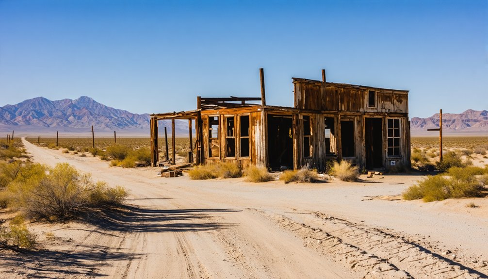
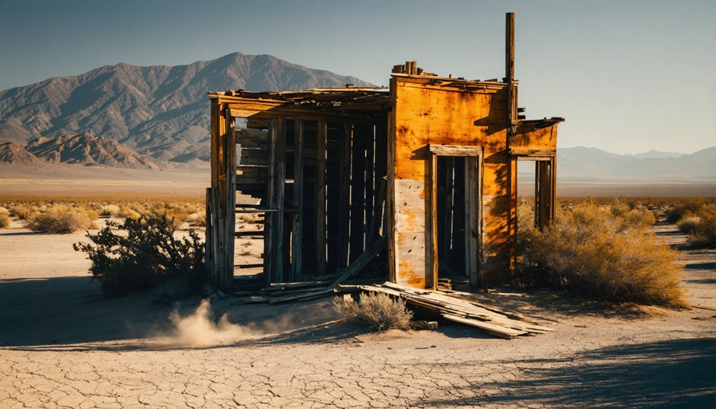
Tucked into the South Fork Valley of the Scodie Mountains, Canebrake is an unincorporated ghost town community sitting at 3,031 feet elevation along California State Route 178 in Kern County.
You’ll find it roughly 5.3 miles east-northeast of Onyx, positioned within the Southern Sierra Nevada’s rugged terrain.
Canebrake history traces back to a late 19th-century gold and silver rush that drew ambitious miners and entrepreneurs chasing wealth through the region’s precious metal veins.
A late 19th-century gold and silver rush sparked Canebrake’s origins, luring miners chasing precious metal wealth.
That mining legacy defined the settlement’s rise and, ultimately, its abandonment once resources ran dry.
Today, no formal municipal government exists here, and the population remains minimal.
What remains draws freedom-seeking travelers enthusiastic to explore California’s boom-and-bust past against a backdrop of sweeping mountain valleys and untamed wilderness.
How the Gold Rush Turned Canebrake Into a South Fork Valley Boomtown
When you stand in Canebrake today, it’s hard to imagine the frenzy that once gripped this quiet South Fork Valley hollow after prospectors struck gold and silver in the surrounding hills during the late 19th century.
Word spread fast, and fortune-seekers flooded in, transforming a remote stretch of the Scodie Mountains into a bustling settlement of miners, entrepreneurs, and opportunists chasing precious metal veins.
The economic pulse of the community quickened almost overnight, with commerce, labor, and ambition driving rapid growth that few isolated California valleys had ever seen.
Gold Discovery Sparks Settlement
Deep in the South Fork Valley, gold and silver discoveries in the late 19th century transformed Canebrake from a quiet stretch of California wilderness into a bustling boomtown.
Fortune-seekers flooded the region when precious metal veins surfaced, igniting a gold rush that drew miners, entrepreneurs, and prospectors hungry for opportunity. You can almost feel that raw energy today as you walk terrain once crowded with ambition and sweat.
Searles’ ventures strengthened the local economy, turning temporary camps into an actual settlement. The mining legacy these early settlers built didn’t last forever — dwindling resources eventually emptied the streets — but their impact remains embedded in the landscape.
Canebrake’s rise and fall tells a distinctly American story of chasing freedom, striking it rich, and facing the inevitable bust.
Mining Boom Draws Prospectors
As word of gold and silver strikes spread through California, Canebrake exploded into a full-fledged boomtown practically overnight.
Ambitious prospectors flooded the South Fork Valley, hauling prospecting tools like picks, pans, and sluice boxes into the rugged Scodie Mountains. They came chasing freedom, fortune, and the thrill of striking it rich on their own terms.
Miners employed diverse mining techniques, from placer panning in streambeds to hard-rock excavation targeting precious metal veins deep underground.
Entrepreneurs followed closely, establishing supply operations that kept the settlement economically alive. Figures like Searles played pivotal roles in sustaining local commerce during peak production years.
You’d have witnessed a raw, energetic community built entirely on grit and opportunity — a defining snapshot of California’s legendary boom-and-bust mining heritage.
Boomtown’s Rapid Economic Growth
Once gold and silver strikes confirmed Canebrake’s mineral wealth, money moved fast through the South Fork Valley. Merchants set up supply stores, entrepreneurs built infrastructure, and workers flooded in seeking wages and opportunity.
That economic transformation reshaped a quiet valley corridor into a bustling hub practically overnight. You’d have witnessed saloons, assay offices, and trading posts competing for space along dusty roads.
Every pick swung underground rippled outward into commerce above it. Searles and other ambitious figures drove ventures that kept capital circulating and ambitions alive.
That mining legacy didn’t last forever, but its intensity defined Canebrake’s character. The boom burned bright, fast, and unapologetically — exactly the kind of raw, self-made energy that still draws freedom-seekers to these forgotten California landscapes today.
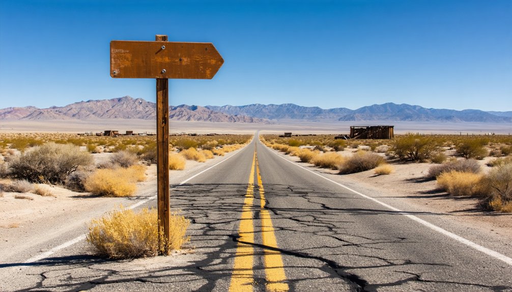
How to Reach Canebrake via California State Route 178
Reaching Canebrake takes you along one of California’s most scenic drives — State Route 178, a winding ribbon of asphalt cutting through the rugged South Fork Valley in the heart of the Southern Sierra Nevada.
You’ll find the community roughly 5.3 miles east-northeast of Onyx, making both towns natural stopping points for supplies and lodging.
Among the best road trip tips: top off your gas tank in Lake Isabella, about 20 miles west, before heading out.
Cell service gets spotty, so download offline maps beforehand.
Roadside scenic viewpoints reward you with sweeping mountain vistas and valley panoramas that feel genuinely untamed.
Parking sits conveniently near the community entrance and trailheads, letting you step out and immediately absorb the raw, unhurried landscape surrounding this forgotten California settlement.
Where to Stay Near Canebrake: Onyx and Lake Isabella

Two towns anchor your Canebrake road trip when it comes to finding a place to sleep: Onyx and Lake Isabella.
Onyx sits just 5.3 miles west, making Onyx accommodations a convenient base for early morning explorations before crowds arrive. It’s small, quiet, and perfectly positioned for a no-fuss overnight stay.
Lake Isabella, roughly 20 miles away, gives you more options. Lake Isabella dining ranges from casual diners to lakeside spots where you can unwind after a dusty day on the trail.
Lake Isabella offers everything from casual diners to lakeside retreats, perfect for unwinding after a dusty trail day.
You’ll also find motels, vacation rentals, and campgrounds that suit travelers who prefer flexibility over formality.
Stock up on supplies in Lake Isabella before heading east on Route 178. Once you leave town, services disappear fast, and Canebrake rewards those who come prepared.
What to Pack for a High-Desert Canebrake Road Trip
Pack layers for Canebrake’s unpredictable high-desert temperatures, sturdy hiking boots for uneven terrain, and sun protection for exposed trails.
You’ll want to carry at least two liters of water per person since no reliable water sources exist along the route, plus trail snacks and emergency rations.
Don’t leave without a downloaded offline map, a paper backup, and a basic first-aid kit, as cell service in the South Fork Valley is notoriously unreliable.
Essential Clothing And Gear
Sitting at 3,031 feet in the high desert of Kern County, Canebrake demands a versatile packing strategy across all four seasons. Weather conditions shift dramatically here — mornings bite with cold, afternoons scorch under relentless sun.
Layer smartly with moisture-wicking base layers, a fleece mid-layer, and a windproof outer shell. Sturdy hiking boots protect your ankles on uneven terrain while keeping you ready for unexpected wildlife encounters with rattlesnakes and other desert creatures.
Pack wide-brimmed hats, UV-blocking sunglasses, and high-SPF sunscreen for daytime exposure. Lightweight gloves and thermal socks handle cool desert nights.
Carry a reliable hydration pack — at least three liters — since water sources are scarce. A basic first-aid kit, trekking poles, and a headlamp round out your essential gear for exploring Canebrake confidently and safely.
Food And Water Supplies
Because no convenience stores or restaurants exist along this remote stretch of Route 178, you’ll need to stock up in Lake Isabella or Onyx before heading out.
Both towns offer local dining options and grocery stops where you can grab everything you need. Pack enough food for your entire trip — trail mix, sandwiches, and energy bars travel well in desert heat.
Water sources don’t exist within Canebrake’s boundaries, so carry more than you think you’ll need.
At 3,031 feet elevation, dry mountain air accelerates dehydration faster than you’d expect. Plan on at least one gallon per person per day.
A quality insulated cooler keeps perishables fresh and your water cold, giving you the freedom to explore without cutting your adventure short.
Once your cooler’s packed and your water supply’s sorted, your next priority is making sure you can actually find your way around — and get help if something goes wrong.
Download offline navigation apps like Maps.me or Google Maps before you leave cell range, because signal along State Route 178 gets unreliable fast. A physical map of Kern County serves as a solid backup.
Pack a first aid kit, a multi-tool, jumper cables, and a basic tire repair kit — desert roads aren’t forgiving.
Share your itinerary with someone back home before you head out.
These safety tips aren’t about limiting your adventure; they’re about protecting it. The more prepared you are, the further and freer you can roam through Canebrake’s rugged, rewarding backcountry.
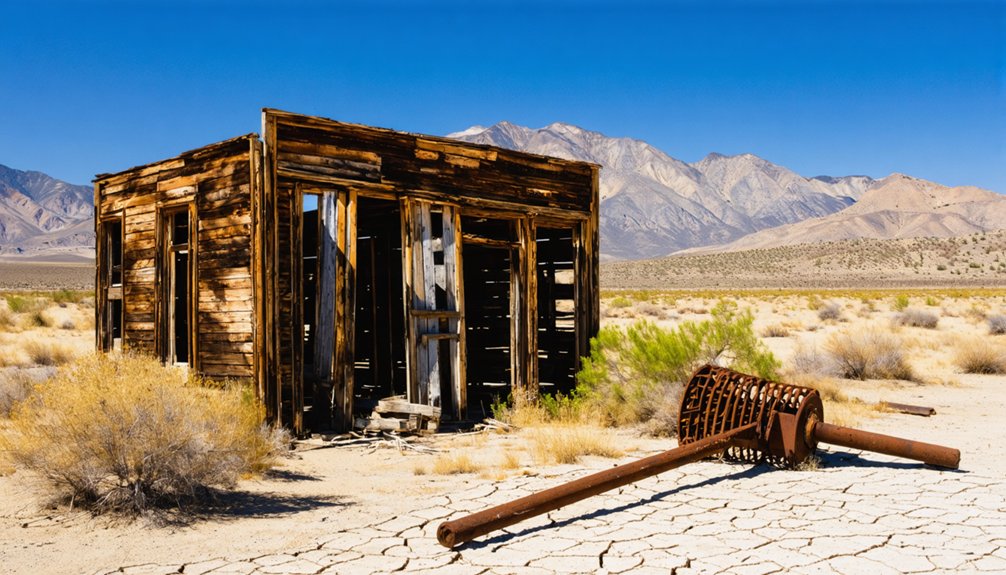
Hiking Trails and Wildlife at the Canebrake Ecological Reserve
Sprawling across 6,700 acres of Kern County terrain, the Canebrake Ecological Reserve gives outdoor enthusiasts a rare chance to explore foothill woodland, sagebrush flats, and wetland habitats all within a single destination.
You’ll find hiking trails winding through each distinct zone, rewarding you with sweeping mountain vistas and quiet valley scenery at every turn.
Wildlife observation is a genuine highlight here. Keep your eyes open for native birds, reptiles, and mammals moving freely through protected corridors.
The reserve’s commitment to ecological conservation means these species thrive in relatively undisturbed conditions, giving you an authentic encounter with California’s natural diversity.
Parking near the trailheads is straightforward, so you can move at your own pace.
After your hike, Onyx and Lake Isabella remain close by for resupply before your next ghost town stop.
Ghost Town Stops Near Canebrake Along Route 178
As you cruise along Route 178, you’ll find that Canebrake sits within reach of several compelling ghost town destinations worth adding to your itinerary.
The route itself carries deep historic weight, threading through communities that once buzzed with mining activity before time and economics emptied them out.
Bodie State Historical Park stands as the crown jewel of nearby stops, offering a remarkably preserved Wild West ghost town that brings California’s boom-and-bust era to vivid life.
Nearby Ghost Town Destinations
Route 178 doesn’t just lead you to Canebrake—it connects you to a string of ghost town destinations that make the drive worth every mile.
Head northeast and you’ll reach Bodie State Historical Park, one of California’s most celebrated ghost town experiences. Bodie’s frozen-in-time streets and weathered buildings showcase authentic historical preservation at its finest, giving you a rare glimpse into the raw energy of California’s mining era.
Closer to Canebrake, the communities of Onyx and nearby abandoned settlements dot the South Fork Valley, each carrying fragments of boom-and-bust stories.
You can move freely between these stops, piecing together a vivid picture of frontier life. Route 178 fundamentally hands you an open road and a living history lesson simultaneously.
Route 178 Historic Stops
Driving along Route 178 puts you squarely in the middle of California’s ghost town corridor, where historic stops reveal the region’s rugged mining past at nearly every turn.
You’ll pass through the South Fork Valley, where remnants of boom-era settlements line the roadside like open-air museums. Onyx sits just 5.3 miles from Canebrake and offers a glimpse into ranching and trading history that predates modern development.
Lake Isabella anchors the western end of your drive, giving you a reliable base before you push deeper into forgotten territory.
Along the way, keep your eyes open for mining artifacts scattered across the landscape and historic landmarks that mark where ambitious prospectors once staked their futures.
Route 178 connects it all without fences or restrictions holding you back.
Scenic Valleys and Mountain Views on the Canebrake Drive
The drive along California State Route 178 through the South Fork Valley rewards you with sweeping mountain vistas and lush valley floors that frame Canebrake’s rugged setting.
You’ll navigate through the Scodie Mountains of the Southern Sierra Nevada, where scenic drives reveal open skies and dramatic terrain at every turn.
Expect these standout views along the route:
- South Fork Valley floors stretching beneath layered mountain ridgelines
- Scodie Mountain peaks rising sharply against clear high-desert skies
- Foothill woodland corridors evolving into open sagebrush flats
- Wetland pockets within the Canebrake Ecological Reserve’s 6,700 acres
- Elevated highway curves offering unobstructed panoramic sightlines at 3,031 feet
You’re not just passing through — you’re experiencing raw California landscape that feels genuinely untouched and yours to discover.
Why Canebrake Belongs on a California Ghost Town Road Trip
Canebrake earns its place on any California ghost town road trip by delivering exactly what the genre promises — a raw, storied landscape shaped by ambition, boom, and eventual silence.
Canebrake history isn’t packaged behind museum glass; you’re reading it through abandoned trails and the quiet valley itself. The mining heritage here reflects California’s broader story — bold prospectors chasing gold and silver until the veins ran dry and the crowds dissolved.
History here isn’t behind glass — it’s written in abandoned trails and the silence of the valley itself.
You’re not visiting a reconstructed attraction; you’re standing where real decisions were made and real fortunes were lost.
Pair that with the ecological reserve, the mountain scenery, and the open road along Route 178, and Canebrake becomes more than a footnote — it becomes a destination worth deliberately choosing.
Other Kern County Ghost Towns Worth Visiting Near Lake Isabella
Several ghost towns scatter across Kern County within easy reach of Lake Isabella, making the area a natural hub for road trip exploration. Each site carries its own historical significance, giving you a richer picture of California’s mining past.
- Sageland – A remote outpost with crumbling foundations telling stories of early settlers.
- Claraville – Once a thriving silver camp tucked into the mountains east of Lake Isabella.
- Whiskey Flat (Kernville) – A relocated mining town preserving its Wild West character.
- Weldon – A small community with deep ranching and mining roots along the Kern River.
- Randsburg – A well-preserved gold mining town offering museums and original storefronts.
You’ll find each stop rewards curiosity and fuels your drive deeper into Kern County’s forgotten frontier.
Frequently Asked Questions
Is Canebrake Listed as an Official California Historical Landmark?
Like a forgotten whisper, Canebrake isn’t listed as an official California Historical Landmark, but you’ll still uncover rich ghost town history and fascinating Canebrake legends waiting to captivate your free-spirited adventure.
Does Canebrake Have a Formal Municipal Government or Local Authority?
You won’t find any formal municipal government or local authority here. Canebrake’s unincorporated status means it lacks structured local governance, so you’re free to explore without community resources tied to traditional administrative oversight controlling your experience.
Are There Any Active Mining Operations Still Running in Canebrake?
You won’t find any active mining operations in Canebrake today. This ghost town’s mining history has long faded, leaving behind only echoes of ambitious prospectors who once chased gold and silver dreams through these rugged, breathtaking landscapes.
What Precious Metals Were Originally Discovered in the Canebrake Area?
Like veins of fortune threading through stone, you’ll find Canebrake’s mining history rooted in gold and silver discoveries. These precious metals ignited a gold rush, drawing bold dreamers chasing wealth and freedom into California’s rugged wilderness.
How Large Is the Canebrake Ecological Reserve in Total Acreage?
You’ll explore 6,700 acres of stunning wilderness in the Canebrake Ecological Reserve, where hiking trails wind through remarkable wildlife diversity, connecting foothill woodlands, sagebrush plains, and wetland habitats that’ll ignite your adventurous spirit and love of freedom.
References
- https://www.youtube.com/watch?v=fSt6eDTslnQ
- https://dualsport-sd.com/forums/index.php?/topic/27439-canebrake-great-overland-stage-route-history/
- https://archive.org/details/ghosttownsmining0000nade
- https://en.wikipedia.org/wiki/Canebrake
- https://www.youtube.com/watch?v=2Foz-2R_mH8
- https://dornsife.usc.edu/magazine/echoes-in-the-dust/
- https://en.wikipedia.org/wiki/List_of_ghost_towns_in_California
- https://wildlife.ca.gov/Lands/Places-to-Visit/Canebrake-ER
- https://www.youtube.com/watch?v=QC3NEZsCSpQ
- https://www.youtube.com/watch?v=OD9M6MP6RRU


